Kansas Geological Survey, Bulletin 114, part 3, originally published in 1955
Originally published in 1955 as Kansas Geological Survey Bulletin 114, part 3. This is, in general, the original text as published. The information has not been updated. An Acrobat PDF version (5 MB) is also available; plates available separately.
A survey of vertical magnetic intensity was conducted in northern Wilson and southern Woodson counties, Kansas, in order to aid in determining the character and extent of the igneous rocks associated with the Rose and Silver City domes. These unique intrusives have at times aroused considerable attention as a possible source of economically useful minerals and rocks. Granite is exposed at the Rose dome and peridotite is exposed at the Silver City dome; both are intruded into sediments as young as the Missourian Series of the Pennsylvanian System.
The survey consisted of a regional magnetic study and detailed magnetic studies of the Rose and Silver City domes. These data are compared with structure maps on top of the Plattsburg limestone of Pennsylvanian age and on top of the Mississippian rocks.
Results of the survey indicate that the magnetometer may be used as a reconnaissance tool to map location and trend of geologic structures in this area, but that it was not successful in determining the character and extent of the intrusive igneous rocks because the intrusives lack magnetic contrast with the sedimentary rocks. The survey indicates also that structural highs are reflected as negative magnetic anomalies. A combination of basement characteristics and thinning or absence of Pennsylvanian sandstones over structural highs may account for this condition.
Outcrops of igneous rocks in Kansas are known only at seven localities; five of these exposures occur in Riley County where basic igneous rocks have intruded rocks of Permian age and two exposures occur in southern Woodson County where igneous rocks have intruded Pennsylvanian rocks. The area studied is in southeastern Kansas in Wilson and Woodson counties (Fig. 1) between Yates Center on the north and Benedict on the south, and includes the Rose and Silver City domes. Granite is exposed at Rose dome and peridotite at Silver City dome.
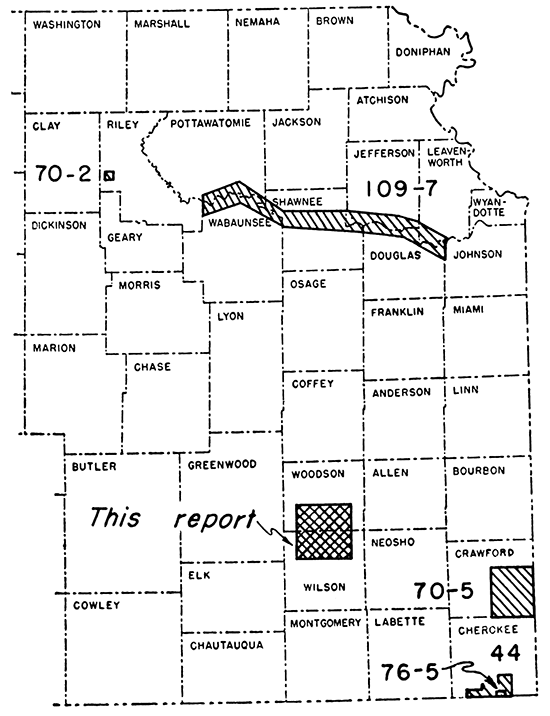
Figure 1--Index map showing location of area described in this report and other areas in which geophysical exploration has been conducted by the State Geological Survey of Kansas (numbers refer to Kansas Geological Survey bulletins).
Because of this paucity of exposures of igneous rocks in Kansas, the granitic and peridotitic intrusives of southern Woodson County have aroused considerable interest as a possible source of economically useful minerals and rocks. The area has been discussed previously by Mudge (1881), Hay (1883), Twenhofel (1917,1926), Moore and Haynes (1920), Twenhofel and Edwards (1921), Twenhofel and Bremer (1928), Knight and Landes (1932), and Weidman (1933). Recent detailed studies by Holly C. Wagner prompted this geophysical study for the purpose of obtaining additional information concerning the character and extent of the intrusive bodies.
A vertical intensity magnetic survey (Pl. 1) was carried on intermittently during the fall of 1953 and the spring of 1954. It consisted of a reconnaissance survey and detailed surveys over the domes. The reconnaissance survey was made to determine regional magnetic variations as a framework for the interpretation of the detailed surveys of the intrusives.
To our knowledge only two other geophysical studies have been made in this area: a magnetic survey and a radioactivity survey. Data concerning the magnetic survey which was made in 1935 were furnished by W. L. Stryker, geologist at Fredonia, Kansas (personal communication). Few readings were taken and the information was not published. The radioactivity survey over the Rose dome was made by R. A. Hartenberger (1948). This survey shows a high radioactivity anomaly at the center of the dome and Hartenberger concluded that the anomaly was caused by the granite.
We are indebted to Holly C. Wagner of the Federal Geological Survey, who furnished geological information, supplied data for the structural maps, and assisted during the early part of the field work. William R. Atkinson helped as field assistant during most of the study.
Paleozoic rocks about 2,500 feet thick overlie the Pre-Cambrian basement complex in northern Wilson and southern Woodson counties. These rocks have a slight northwesterly regional dip. A map showing the general configuration of the top of the Pre-Cambrian surface of eastern Kansas has been published by Jewett (1954, p. 58). The stratigraphy is treated only briefly here; the reader is referred to Moore and others (1951), Wagner and Harris (1953), and Wagner (1954) for a more complete discussion and description of the rocks.
Granite crops out in sec. 13, T. 26 S., R. 15 E. near the crest of the Rose dome. Contact zones in Pennsylvanian shale indicate that the granite intruded Pennsylvanian rocks. Knight and Landes (1932, p. 14) have suggested that this intrusive is a dike. Small outcrops of peridotite occur at several places in secs. 29 and 32, T. 26 S., R. 15 E. at the Silver City dome. There are also numerous outcrops of quartzite and other metamorphosed sedimentary rocks in the vicinity of the peridotite intrusive. A study of the altered zones around the peridotite and the metamorphosed rocks indicates that the peridotite was intruded into Pennsylvanian rocks (Wagner, personal communication).
The sedimentary rocks that crop out in the area include the Stanton limestone and Weston shale of the Missourian Series and the Stranger formation and Lawrence shale of the Virgilian Series of Pennsylvanian age. The Iatan limestone is not present in the area. The Tonganoxie sandstone member of the Stranger formation and the Ireland sandstone member of the Lawrence shale, which form prominent topographic benches in the area, are absent over the Rose and Silver City domes. The Tonganoxie has an average thickness of about 30 feet and the Ireland about 25 feet. In the vicinity of the intrusives the sandstones may be distinctly reddish rather than the common yellowish-orange color.
Igneous rocks of various descriptions have been reported in wells drilled near the intrusives. These rocks are thin and are intercalated with the normal sequence of rocks in the section.
Pennsylvanian rocks of the Lansing, Kansas City, Pleasanton, Marmaton, and "Cherokee" groups are present in the subsurface of northern Wilson and southern Woodson counties. These rocks consist of alternating shale, limestone, and sandstone. The lenticular sands in the "Cherokee" group have a high magnetite content (Dreyer, 1947, p. 109).
Mississippian rocks which underlie the Pennsylvanian rocks consist mainly of limestone and dolomite which contain large amounts of chert. The Chattanooga shale, of Mississippian or Devonian age, underlies the Mississippian rocks.
The Arbuckle group of Cambro-Ordovician age underlies the Chattanooga shale and overlies the Pre-Cambrian basement complex. These rocks consist mainly of limestone and dolomite.
Regionally, the area lies on the northern flank of the Cherokee basin. The structure consists mainly of low undulating folds and small normal faults with little displacement. Structural maps (Pl. 2) may be compared with the magnetic map (Pl. 1) to show the relation between rock structure and magnetic anomalies. The structure maps are based on information available to the State Geological Survey on January 1, 1954. Lee and Merriam (1954) discuss the structural development of eastern Kansas.
Plate 2A shows by 50-foot contours the regional structure on the base of the Plattsburg limestone of Pennsylvanian age. The map combines both surface and subsurface data. The regional dip of the beds is northwest about 25 feet to the mile.
Two prominent anticlinal trends are shown. One extends southeast-northwest through Buffalo and the Silver City dome to about 1% miles southwest of Batesville and the other southwest-northeast from southeast of Coyville through the Silver City and Rose domes to sec. 11, T. 26 S., R. 16 E. Minor synclines and anticlines paralleling these major trends are also recognizable.
Structural map on the top of Mississippian rocks.-Plate 2B shows by 50-foot contours the structure on top of the Mississippian rocks. The regional dip of the beds is northwest about 35 feet to the mile. The major structural trends are in approximately the same position and have about the same directional trend as the structures on the base of the Plattsburg limestone.
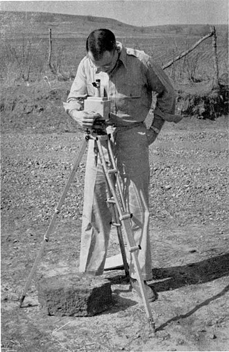
A Ruska vertical magnetometer (Pl. 3) was used in the geophysical survey. The instrument has a sensitivity of 11.3 gammas per scale division and is thermally compensated. Instrument readings for the regional magnetic investigation were taken on a 1 mile grid, usually at section corners. Readings were taken on a 40 acre or less spacing for the detailed investigations at Rose and Silver City domes. A magnetic datum of 340 gammas was assumed for a base station located at a road junction in the SW cor. SW sec. 36, T. 26 S., R. 15 E. Instrument readings were corrected for diurnal variation, latitude and longitude, and annual variation. County road maps, prepared by the Kansas Highway Department, were used for base maps in the regional survey. U. S. Department of Agriculture aerial photos were used to locate stations for the detailed surveys. Care was taken to avoid culverts, cased oil wells, steel fences, power lines, etc., which would tend to distort the natural magnetic field.
Plate 3--Field operation of a Ruska vertical magnetometer.
The magnetic irregularities at the earth's surface resulting from differences in magnetic intensity are called magnetic anomalies. These anomalies are termed "negative" or magnetic "lows" if less than the "normal" intensity and are "positive" or magnetic "highs" if more than the "normal" intensity. Such anomalies generally are produced by differences in magnetic susceptibility which in turn largely reflect the magnetite content of the rocks. For the most part, igneous and metamorphic rocks are more magnetic than sedimentary rocks. Among the sedimentary rocks, clastic deposits such as sandstone and shale are more magnetic than non clastics such as limestone and dolomite. A list of rocks and minerals and their relative magnetic susceptibilities is given by Jakosky (1950, p. 164).
Inasmuch as magnetic intensity is an inverse square function, the distance of any magnetic body from the magnetometer affects the size of the anomaly. Structures such as folds and faults in deep-seated or basement rocks usually produce anomalies since more (or less) magnetic rocks may be brought closer to the surface. Deeply buried rocks might be expected also to produce lesser anomalies than similar rocks near the surface or even be masked by near-surface irregularities.
The results of the regional magnetic survey are shown on Plate 1 by means of isogams (lines of equal vertical magnetic intensity) plotted at a 20-gamma interval. The map reveals a series of south-southeast-north-northwest trending anomalies. Prominent negative or low trends extend (1) from sec. 5, T. 27 S., R. 14 E., just east of Coyville, to sec. 2, T. 28 S., R. 14 E.; (2) from Batesville in the northwest corner of the area southeastward to about 3 miles west of Benedict; and (3) from just west of Rose through Buffalo to just east of Roper. Several local negative closures occur on these trends. The most prominent of these lies just east of Roper in sec. 25, T. 27 S., R. 15 E. and sec. 30, T. 27 S., R. 16 E. and has a closure of at least 160 gammas. Other large anomalies are located in the NW% sec. 5, T. 27 S., R. 14 E. with possibly 140 gammas of closure and in sec. 25, T. 26 S., R. 14 E. with a closure of about 100 gammas. Lesser negative anomalies are located in sec. 30, T. 27 S., R. 15 E. with a closure of 20 gammas; sec. 12, T. 26 S., R. 15 E. with a closure of 20 gammas; and secs. 2 and 3, T. 26 S., R. 16 E. with about 40 gammas closure. Most of these anomalies have a north-south elongation and trend either slightly east or west of north. The anomaly east of Roper is more ovoid in shape.
Three positive trends separate the parallel negative trends and extend (1) from southwest of Batesville to sec. 1, T. 28 S., R. 14 E.; (2) from northeast of Batesville to secs. 4 and 5, T. 28 S., R. 15 E.; and (3) from sec. 29, T. 25 S., R. 16 E. to secs. 11 and 12, T. 27 S., R. 16 E. There are several areas of positive closure along the trends. The most prominent of these is in sec. 8, T. 26 S., R. 15 E. and has an 80-gamma closure. Others of lesser magnitude are located in sec. 5, T. 28 S., R. 14 E. with a closure of about 20 gammas; sec. 10, T. 26 S., R. 14 E. with a closure of 20 gammas; sec. 3, T. 27 S., R. 15 E. with more than 20 gammas closure; and in secs. 4 and 5, T. 28 S., R. 15 E. with a possible closure of about 40 gammas. The positive anomalies all have a north-south elongation with a trend slightly west of north. In general the positive anomalies are of lesser magnitude than the negative anomalies.
Comparison of the magnetic map (Pl. 1) with the structural map on the base of the Plattsburg limestone of Pennsylvanian age (P1. 2A) shows that there is some coincidence of magnetic and structural trends. The negative anomaly trend which begins just south of Batesville coincides with the anticlinal trend in that part of the area. However, the negative anomaly continues southeasterly whereas the anticlinal trend swings east through Buffalo. The northeast-southwest anticlinal trend of the structure map is not as sharply defined as the series of magnetic anomalies. A possible coincident trend of negative anomalies and anticlinal structure begins northeast of Rose and continues southwest to just north of Coyville.
A study of structure in comparison to magnetic anomalies indicates close relation between structural highs and negative magnetic anomalies although, at most places, the magnetic lows are displaced to the northwest of the structure. Examples are Rose dome, the structure northeast of Rose, the Silver City dome, and the structure east of Roper. Reason for displacement in this area is not known. According to Jakosky (1950, p. 225) the following factors may contribute: (1) inclination of the earth's magnetic field; (2) the igneous core is not in conformity with overlying sedimentary rocks; (3) basement rocks are not of uniform magnetic properties; (4) the structural axis of the sedimentary structure shifts with depth. Inclination of the earth's field can have little contributory effect in this area since displacement should be to the south. Shift of structural axis with depth seems the most likely of the explanations.
The structural map on the top of Mississippian rocks (Pl. 2B) shows relations similar to those shown on the Plattsburg structural map although a northeast-southwest Mississippian structural trend is the most evident. The structural highs are more elongated in the direction of the trend than are the negative anomalies. Comparison of magnetic and structural data indicates that negative anomalies coincide reasonably well with structural highs but that the negative anomalies again are displaced to the northwest at the Rose and Silver City domes. The negative anomaly and the structural high northeast of Rose dome show some coincidence. However, displacement of the magnetic anomaly is southeast instead of northwest as it is on the Pennsylvanian structure map. This may be due to a control factor, because less data are available for the Mississippian map.
As the main purpose of the magnetic survey was to aid in determining the character and extent of the intrusive bodies at Rose and Silver City, detailed investigations of the anomalies at these locations were made. This work was undertaken after the conclusion of the regional study.
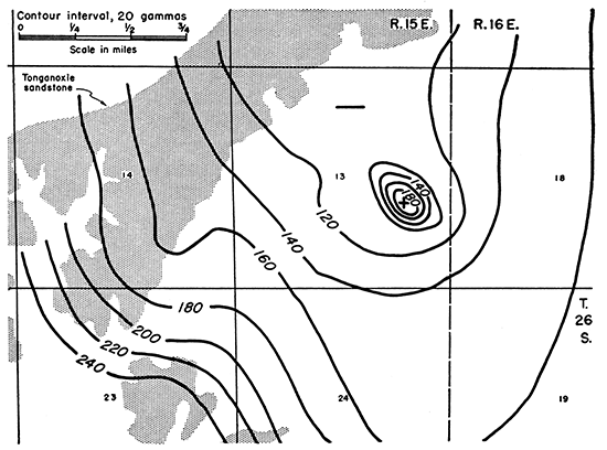
The detailed study of the Rose area (Fig. 2) shows that a positive anomaly is superposed on the regional negative anomaly. This magnetic high is in the southeastern part of sec. 13, T. 26 S., R. 15 E. and covers an area of about 40 acres where granite is exposed. The minor effect of the granite and its small sphere of influence were determined by taking magnetometer readings directly on the granite and at adjacent places where granite was not exposed. A difference of only 60 gammas was noted. The granite body probably is tabular, in form with dike or sill characteristics, as the outcrop area is narrow and metamorphic contacts show its limits and intrusive nature.
Figure 2--Detailed vertical intensity magnetic map of the Rose dome area in Woodson County. The outcrop pattern of the Tonganoxie sandstone member is also shown; +, positive anomalies; -, negative anomalies.
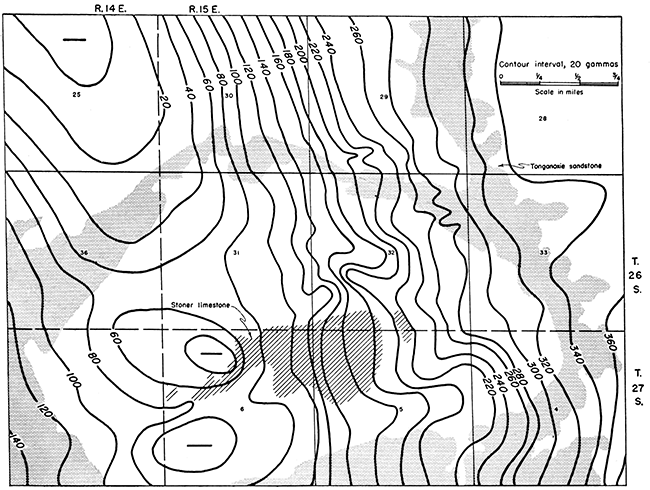
The detailed study of the Silver City area (Fig. 3) reveals that the character of the magnetic anomaly as determined on a reconnaissance basis is little changed by detailed study. The single low is resolved into two magnetic lows of about equal closure. The magnetic lows are displaced to the west of the structural high and there is no marked coincidence of magnetic and structural contours. The peridotite at the surface has little effect on the magnetic readings as indicated by the isogams cutting across igneous-sedimentary contacts. The irregularity of the contours in the southwestern part of sec. 32, T. 26 S., R. 15 E. may indicate the location of the feeder for the intrusion.
Figure 3--Detailed vertical intensity magnetic map of the Silver City dome area in Wilson and Woodson counties. The outcrop patterns of the Tonganoxie sandstone member and the Stoner limestone member are shown; +, positive anomalies; -, negative anomalies.
Conclusions resulting from the study are premised on certain basic assumptions regarding the relation between magnetic and geologic data in this area. (1) The magnetic anomalies are produced by sandstones or shales in Pennsylvanian rocks, by igneous and metamorphic rocks of the basement complex, by intrusive igneous rocks, or by a combination of these factors. Sedimentary rocks older than Pennsylvanian consist mainly of limestone and dolomite which have low magnetic susceptibility whereas shale, and especially sandstone of relatively high magnetic susceptibility is common in Pennsylvanian rocks. In addition, igneous rocks usually have a relatively high magnetic susceptibility and such rocks are known to be present in the basement complex and intercalated with sediments at places in this area. (2) Because there is coincidence of magnetic lows with known structural highs at certain places, it is assumed that all magnetic lows reflect structural highs. This concept gains validity from comparison with Dreyer's (1947) study in southeastern Crawford County, Kansas, where conditions are similar. (3) Mississippian and Pennsylvanian structures, for the most part, are a reflection of basement structure. However, it must be remembered that basement rocks have been involved in all structural deformation of the area, which has been mainly post-Mississippian, and that divergence of deep-seated and near-surface structure should be reflected in the magnetic data. The effects of structures produced by differential compaction not related to basement structure are discounted because of the marked magnetic linear trends discussed earlier. This assumption may not be justified completely. Exceptions are the Rose and Silver City domes where structure results largely from intercalation of igneous rocks (Wagner, 1954). However, location of the domes on structural trends suggests that intrusion took place along zones of weakness in the basement complex and that even these domes probably reflect basement structure.
On the basis of these assumptions, several possibilities are suggested to account for the coincidence of magnetic lows and structural highs. (A) The anomalies are caused by basement rocks alone. Thus, a structural high would produce a magnetic low if the basement rocks exhibit inverse polarity. The possibility of variation in basement rock type, hence magnetic susceptibility, must be considered but it is evident that this factor would not be reflected in Mississippian and Pennsylvanian structures. (B) Dreyer (1947, p. 111) reports that "Cherokee" sandstones have a magnetic field of sufficient magnitude to account for anomalies in Crawford County and Paul C. Franks (personal communication) reports a magnetite content as high as 8 percent for the Ireland and Tonganoxie sandstone members in this area. Thinning of such sandstones over a structural high would decrease the magnitude of the anomaly and produce, in effect, a negative anomaly. Variations in the magnetite content of these sediments could produce seeming magnetic lows. Such variations could result from the effects of "Cherokee" channel or beach sands. This is considered unlikely because the anomalies parallel distinct structural trends and no anomalies were evident at places where there is oil and gas production from known "Cherokee" sands. (C) The anomalies are caused by both basement rocks and Pennsylvanian sandstones. In this event, the near-surface sedimentary rocks would tend to modify or mask the effects of the deeper basement rocks and differentiation of causes would be difficult. Dreyer (1947, p. 111) has discussed a number of conditions and effects for a situation of this type. The presence of intrusive igneous rocks would modify further the character of an anomaly since such rocks should produce a magnetic high.
There are two distinct geologic conditions in the part of Wilson and Woodson counties studied. The first involves structural highs associated with intrusive rocks and the second, structural highs where no intrusive rocks are evident either at the surface or in the subsurface.
The granite and peridotite might be expected to produce positive magnetic anomalies where structural highs are associated with intrusives, such as at Rose and Silver City domes. However, petrographic examination of thin sections indicates that neither of these rocks has an average magnetite content higher than 2 percent. These rocks, therefore, should produce relatively low-order positive anomalies, which seems to be illustrated by the detailed study at nose dome. Alternately, an explanation of these anomalies lies in the absence of Ireland and Tonganoxie (Figs. 2, 3) sandstone members over the domes. Because these sandstones have a relatively high magnetite content, their absence would result in magnetic lows. The presence of granite or peridotite would tend to compensate for the negative anomaly produced by the absence of the sandstone and would superimpose a magnetic high on the magnetic low at places where the igneous rocks crop out, as at Rose dome. Because the peridotite has a lower susceptibility than the granite, there is no superimposed magnetic high at Silver City dome.
If no igneous rocks are involved, the anomalies may be due to the absence of magnetite-bearing sandstone. Thinning or absence in the subsurface of other Pennsylvanian rocks, such as the "Cherokee," may produce negative anomalies over structural highs. However, the anomalies probably are the product of both basement and sedimentary rock effects for negative anomalies do not always coincide with Mississippian or Pennsylvanian structural highs.
Seemingly the vertical magnetometer can be used successfully as a reconnaissance tool in Wilson and Woodson counties to map the location and trend of geologic structures. The present survey confirms the major known structural features indicated by surface and subsurface mapping and indicates the possible occurrence of additional structure.
Magnetic lows indicate structural highs and magnetic highs indicate structural lows in this area. The condition probably is caused by a combination of basement characteristics and thinning or absence of Pennsylvanian sandstones over structural highs.
The vertical magnetometer was not especially successful in the determination of the character and extent of the intrusive igneous rocks at Rose and Silver City domes owing to lack of contrast between magnetic susceptibility of igneous and sedimentary rocks.
Dreyer, R. M. (1947) Magnetic survey of southeastern Crawford County, Kansas: Kansas Geol. Survey, Bull. 70, pt. 5, pp. 105-115. [available online]
Hartenberger, R. A. (1948) Radioactivity survey over the Rose dome: Kansas Geol. Survey, open file.
Hay, Robert (1883) The igneous rocks of Kansas: Kansas Acad. Sci. Trans., vol. 8, pp. 14-18.
Jakosky, J. J. (1950) Exploration geophysics: Trija Publ. Co., Los Angeles, Calif., pp. 1-1195.
Jewett, J. M. (1954) Oil and gas in eastern Kansas: Kansas Geol. Survey, Bull. 104, pp. 1-397.
Knight, G. L., and Landes, K. K. (1932) Kansas laccoliths: Jour. Geology, vol. 40, no. 1, pp. 1-15.
Lee, Wallace, and Merriam, D. F. (1954) Cross sections in eastern Kansas: Kansas Geol. Survey, Oil and Gas Investi., No. 12, Cross Secs., pp. 1-8.
Moore, R. C., and Haynes, W. P. (1920) An outcrop of basic igneous rock in Kansas: Am Assoc. Petroleum Geologists, Bull., vol. 4, no. 2, pp.183-187.
Moore, R. C., and others (1951) The Kansas rock column: Kansas Geol. Survey, Bull. 89, pp. 1-132. [available online]
Mudge, B. F. (1881) Metamorphic deposit in Woodson County: Kansas Acad., Sci. Trans., vol. 7, pp. 11-13.
Twenhofel, W. H. (1917) Granite bowlders in (?) the Pennsylvanian strata of Kansas: Am. Jour. Sci., 4th ser., vol. 43, no. 257, pp. 363-380.
Twenhofel, W. H. (1926) Intrusive granite of the Rose dome, Woodson County, Kansas: Geol. Soc. America Bull., vol. 37, no. 2, pp. 403-412.
Twenhofel, W. H., and Bremer, Bernard (1928) An extension of the Rose dome intrusives, Kansas: Am. Assoc. Petroleum Geologists Bull., vol. 12, no. 7, pp.757-762.-
Twenhofel, W. H., and Edwards, E. C. (1921) The metamorphic rocks of Woodson County, Kansas: Am. Assoc. Petroleum Geologists Bull., vol. 5, no. 1, pp. 64-74.
Wagner, H. C. (1954) Geology of the Fredonia quadrangle, Kansas: U. S. Geol. Survey, Geologic Quadrangle Maps of the U. S., GQ 49.
Wagner, H. C., and Harris, L. D. (1953) Stratigraphy of the outcropping Pennsylvanian rocks of the Fredonia quadrangle, Kansas: U. S. Geol. Survey, Oil and Gas Investi., Chart OC 48.
Weidman, Samuel (1933) Igneous intrusives in Silver City area, Kansas: Am. Assoc. Petroleum Geologists Bull., vol. 17, no. 10, pp. 1268-1270.
Kansas Geological Survey
Placed on web Feb. 28, 2013; originally published in May 1955.
Comments to webadmin@kgs.ku.edu
The URL for this page is http://www.kgs.ku.edu/Publications/Bulletins/114_4/index.html