![]()
Prev Page--Quality || Next Page--References
Mineral Resources
Ceramic Materials
The Dakota and Kiowa Formations are the principal potential sources of ceramic materials in Rice County. The Dakota clays fire white, buff, and red, and are dominantly kaolinitic and noncalcareous. The clays of the Dakota have excellent qualities for use in the ceramic industry.
The Kiowa Formation, although largely clay, is not as desirable for use in the ceramic industry. The Kiowa clays have high shrinkage values, fire to undesirable dark colors, and tend to bloat when fired. They would be most useful in the manufacture of lightweight aggregate.
The geologic map shows the areas where the Dakota and Kiowa Formations crop out. The Dakota is poorly exposed, being overlain in much of the area by Pleistocene deposits. The Dakota and the Kiowa are not utilized in the county as ceramic material.
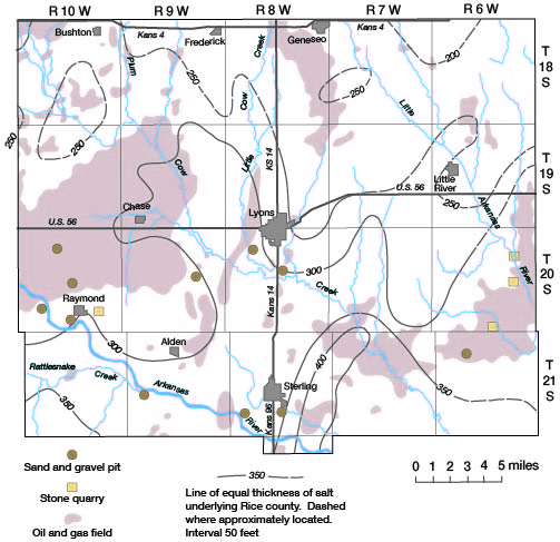
Salt
Salt underlies all of Rice County; thickness of the salt ranges from about 200 feet in the northeastern part of the county to about 400 feet in the south-central part. The salt occurs in the Hutchinson Salt Member of the Wellington Formation of Permian age. The mineral resources map (fig. 12) shows the thickness of salt in the county. The percentage of pure salt ranges from about 60 percent in the central and southwestern parts of the county to about 90 percent in the northern and eastern parts. Beds of shale and anhydrite occur throughout the salt beds. Rock salt has been mined at Little River and from two mines at Lyons. Salt has been produced by the brine process at Lyons and Sterling. Only one company produces salt in Rice County at present. The American Salt Co. at Lyons mines rock salt from a depth of about 1,000 feet and produces salt from brine.
Figure 12--Mineral resources of Rice County.
Oil and Gas
Petroleum is the principal mineral resource in Rice County. Oil was first produced in the County in 1922, and gas was produced as early as 1888. In 1969, 76 fields produced oil and 19 produced gas in the county. In 1969, 4,587 thousand barrels of oil and 713,238 thousand cubic feet of gas were produced. Cumulative production after the first discovery was 277,348 thousand barrels of oil and 42,066,582 thousand cubic feet of gas in 1969. The mineral resources map shows the location and extent of oil and gas fields in Rice County. [For current information on oil and gas production, see the Survey's oil and gas page for Rice County.]
Sand, Gravel, and Stone
In Rice County, road-surfacing material and concrete aggregate are mined from thick deposits of sand and gravel. Eleven pits have been opened for commercial production in the valleys of Arkansas River and Cow Creek; however, not all these pits are operating at present.
Sandstone has been quarried locally in limited quantities in Rice County for use as building stone. The Stone Corral Formation has been quarried along the west margin of the Little Arkansas River valley. This stone has been crushed and used as road material and concrete aggregate. The mideral resources map shows the location of sand and gravel pits and stone quarries in the county.
Prev Page--Quality || Next Page--References
Kansas Geological Survey, Geology
Placed on web Aug. 19, 2008; originally published April 1974.
Comments to webadmin@kgs.ku.edu
The URL for this page is http://www.kgs.ku.edu/General/Geology/Rice/06_mine.html