![]()
Prev Page--Introduction || Next Page--Ground Water
Geology
[Note: The classification and nomenclature of the rock units used in this report are those of the State Geological Survey of Kansas and differ somewhat from those of the U.S. Geological Survey.]
Wells drilled in the exploration for oil and gas have been the source of many data on the lithology and thickness of the rocks underlying Rice County.
Precambrian rocks consisting of granite, schist, and diabase, and clastic sedimentary rocks believed to be of Precambrian age underlie Paleozoic and younger rocks in the county (table 1) at depths ranging from 3,700 to 4,100 feet below land surface. Marine Cambrian and Ordovician rocks were deposited on the basement rocks. Silurian and Devonian rocks are absent. The pre-Mississippian uplift of the Ellis arch, which extends into the county from the northwest, caused tilting and beveling of the Cambrian and Ordovician rocks along the flanks of the uplift and caused the removal of any Silurian and Devonian rocks that may have been present. Mississippian rocks were deposited forming an angular unconformity with the rocks below. These Mississippian rocks were subsequently tilted and uplifted during the formation of the Central Kansas uplift and were eroded during Late Mississippian and Early Pennsylvanian time. Following this period of erosion, Pennsylvanian and Permian rocks were deposited.
Table 1--Generalized section of geologic formations.
| Era | System | Series | Stage | Stratigraphic Unit |
|---|---|---|---|---|
| Cenozoic | Quaternary | Pleistocene | Recent and Wisconsinan |
Alluvium |
| Terrace deposits | ||||
| Dune sand | ||||
| Bignell Formation | ||||
| Peoria Formation | ||||
| Illinoisan | Loveland Formation | |||
| Kansan | Undifferentiated fluvial deposits | |||
| Nebraskan | ||||
| Tertiary | Pliocene | Ogallala Formation | ||
| Mesozoic | Cretaceous | Lower | Dakota Formation | |
| Kiowa Formation | ||||
| Cheyenne Sandstone | ||||
| Paleozoic | Permian | Lower | Harper Sandstone | |
| Stone Corral Formation | ||||
| Ninnescah Shale | ||||
| Wellington Formation | ||||
| Pennsylvanian | Undifferentiated rocks (Includes Arbuckle Group of Late Cambrian and Early Ordovician age) |
|||
| Mississippian | ||||
| Ordovician | ||||
| Cambrian | ||||
| Precambrian | ||||
The Permian formations that crop out in Rice County are all Early Permian in age. The red and green Ninnescah Shale is exposed in the valley walls of the Little Arkansas River in eastern Rice County. The Ninnescah is overlain by the Stone Corral Formation. Where the Stone Corral crops out, it consists of limestone and dolomite, but the formation contains much anhydrite and gypsum in the subsurface. The Harper Sandstone, which consists of red siltstone and very minor amounts of fine-grained sandstone, overlies the Stone Corral Formation and represents the uppermost Permian unit in Rice County.
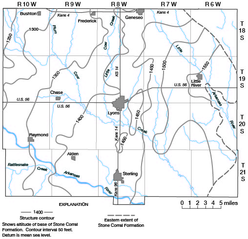
Figure 3 shows the configuration of the base of the Stone Corral Formation. Minor structures on surficial or near-surface rocks are reflected in the deeper rocks and closure on shallow structure increases with depth. As an example, the structure shown near the SE cor. sec. 35, T. 19 S., R. 8 W., has about 70 feet of closure on the Stone Corral Formation, but this structure has more than 200 feet of closure on the Ordovician rocks.
Figure 3--Configuration of the base of the Stone Corral Formation.
Rice County was subject to erosion during Triassic and Jurassic time, and Permian rocks younger than the Harper Sandstone probably were removed during this period. The erosion created a major unconformity that marks the contact of the Permian and the overlying Cretaceous rocks.
Deposition was renewed during Early Cretaceous time, and fine-grained sandstones and siltstones of the Cheyenne Sandstone were deposited in northwestern Rice County. This unit, which does not crop out in the county, is overlapped by the Kiowa Formation. The dark shales and fine-grained sandstones of the Kiowa were deposited in a nearshore marine environment. As these seas receded, silt, clay, and sand of the Dakota Formation were deposited in a lowlying nearshore nonmarine environment. Part of the material may have been deposited as offshore bars in a marine environment.
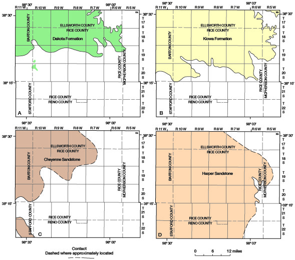
Deposition continued during Late Cretaceous time, but the many hundreds of feet of Upper Cretaceous rocks were removed by subsequent erosion. Thus, the Graneros Shale, Greenhorn Limestone, and Carlile Shale of Late Cretaceous age are not present in Rice County. The distribution of geologic units on the bedrock surface is shown on figure 4. The areal extent of four of the bedrock units above the Stone Corral Formation is shown on figure 5.
Figure 4--Approximate distribution of geologic units on the bedrock surface in and near Rice County.

Figure 5--Areal extent of four bedrock units above the Stone Corral Fomation in and near Rice County.
During the Tertiary period, little, if any, deposition occurred within Rice County. A mature caliche, believed to be a soil caliche that developed during late Pliocene time, is present locally on the bedrock surface. This caliche is considered to represent the Ogallala Formation. At the end of Pliocene time, the area was one of low relief, sloping toward the east and southeast.
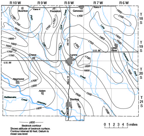
Renewed erosion during earliest Pleistocene time dissected the Pliocene erosional surface, and deep channels were eroded into the Permian and Cretaceous rocks. These channels, shown on the geologic sections (fig. 6), were partly filled with fluvial deposits during the Nebraskan Stage of the Pleistocene Series and partly re-excavated and filled during the Kansan Stage. In upland areas, the bedrock was probably exposed throughout early Pleistocene time. Figure 7 shows the configuration of the bedrock surface beneath the Pleistocene deposits.
Figure 6--Geologic sections. Traces of sections are shown on plate 1. A larger version of this figure is also available.
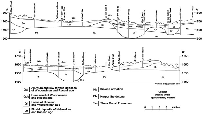
Figure 7--Configuration of the bedrock surface beneath unconsolidated deposits.
During the Illinoisan Stage, loess and some waterlaid silt were deposited. Coarse-grained fluvial deposits of this age are absent in the area. Loess and silt of Illinoisan age, which probably were deposited in most of Rice County, either were buried by Wisconsinan loess or were eroded by Wisconsinan streams.
The geohydrologic map (pl. 1) shows the distribution of the exposed geologic units in the county. Bedrock units crop out principally in the eastern and northeastern parts of the area; however, isolated outcrops of Kiowa and Dakota Formations occur throughout the area. The Ogallala Formation is represented only by isolated outcrops of soil caliche that rest directly on the bedrock.
The Pleistocene geology can be divided into many units. On the geologic map, however, units with similar water-bearing characteristics are grouped together into three main categories: loess, done sand, and alluvium and terrace deposits.
Loess shown on the geohydrologic map probably represents three different formations. The Loveland Formation of Illinoisan age is present in the basal part of the loess in much of the area. Overlying the Loveland are the Peoria Formation (middle unit) and the Bignell Formation (upper unit) of Wisconsinan age. The loess, which comprises these three formations, occurs principally in upland areas and generally rests on bedrock. In part of the area, however, the loess overlies fluvial deposits in early Pleistocene channels shown on the bedrock-configuration map (fig. 7).
Dune sand overlies principally Wisconsinan and Recent alluvium and terrace deposits in the valleys of the Arkansas River and Cow Creek. Dune sand directly overlies Cretaceous bedrock locally in the west-central part of the county, and it overlies fluvial deposits in early Pleistocene channels in the western part of the county. In southeastern Rice County dune sand overlies Permian rocks.
Recent alluvium and Wisconsinan terrace deposits occur in the valleys of Arkansas River, Cow Creek, Little Arkansas River, and their principal tributaries. In the Arkansas River valley and Cow Creek valley, these deposits contain much arkosic sand and gravel derived from a source west of Rice County. In the Little Arkansas River valley and most tributary valleys, the deposits are fine grained and are derived primarily from local materials. Locally, in the Arkansas River valley and Cow Creek valley, these deposits overlie fluvial deposits in early Pleistocene channels.
Prev Page--Introduction || Next Page--Ground Water
Kansas Geological Survey, Geology
Placed on web Aug. 19, 2008; originally published April 1974.
Comments to webadmin@kgs.ku.edu
The URL for this page is http://www.kgs.ku.edu/General/Geology/Rice/03_rock.html