![]()
Prev Page--Geology || Next Page--Quality
Ground Water
Fresh water is obtained in Rice County from wells in unconsolidated Pleistocene deposits to depths of about 100 feet and from consolidated rocks to depths of about 220 feet. The best aquifers are the unconsolidated alluvium and terrace deposits in the valleys of the Arkansas River, Cow Creek, Little Arkansas River, and tributaries to these streams. Small quantities of fresh water are obtained from loess deposits in the uplands area and from dune sand. Aquifers in consolidated rocks are the shales, siltstones, and sandstones of Permian and Cretaceous age.
Deep Paleozoic Aquifers
Little water is contained in most of the deep Paleozoic rocks in Rice County. Small quantities of highly mineralized water are contained in Lower Permian rocks to a depth of several hundred feet below the Hutchinson Salt Member of the Wellington Formation. Some horizons are capable of yielding or receiving large quantities of water. About 260,000 barrels of brine are produced each day along with the production of oil. About 80,000 barrels per day of this brine is injected into the producing zones in the secondary recovery of oil. The remaining 180,000 barrels per day is disposed into rocks of Cambrian and Ordovician age (Arbuckle Group) under gravity head at depths ranging from 3,200 to 3,500 feet.
Permian Aquifers
A little water of poor quality is obtained from shallow wells in the weathered part of the Ninnescah Shale and the Harper Sandstone in Rice County. Small supplies of poor quality water are obtained locally from the Stone Corral Formation. In the area about 1 mile northeast of Lyons, wells in the Stone Corral have maximum yields ranging from about 1/2 to 3 gpm (gallons per minute). East of this area, near the outcrop, solution of evaporites probably has increased the permeability of the unit and somewhat larger quantities of water are available. North and northwest of Lyons, where the Stone Corral is more deeply buried, little or no water can be obtained from the unit.
Cretaceous Aquifers
The principal bedrock aquifers of Rice County are sandstone beds within the Kiowa and Dakota Formations of Cretaceous age. These sandstone beds pinch and swell laterally in thickness and are lithologically dissimilar. Therefore, the yields of wells in either the Kiowa or the Dakota may differ considerably over short distances. The Kiowa Formation in Rice County is about 140 feet thick where a full section is present; however, this unit has been eroded and thins to a feather edge toward the south and east. Probably no more than 150 feet of Dakota is present; the unit thins to a feather edge toward the south and east. Generally, about 30 percent of the Dakota section is composed of sandstone, whereas the percentage of sandstone in the Kiowa section is somewhat less. Sandstone may occur throughout the Dakota, but sandstone in the Kiowa generally is more prominent in the upper part.
Maximum yields to wells that can be expected from the Kiowa in the county is about 50 gpm. In areas where the sandstones in the upper part of the Kiowa have been eroded, little or no water can be obtained from the unit.
Yields to wells in the Dakota range from only a few gallons per minute where the unit is thin or where little sandstone is present to as much as 150 gpm where the unit is thick and more sandstone is present.
Many stock and domestic wells withdraw water from the Kiowa and Dakota in the county. Little River obtains part of its municipal water from the Kiowa Formation, and the cities of Bushton and Geneseo utilize the Dakota for their municipal supplies.
The Cheyenne Sandstone is present only in the extreme western and northwestern parts of the county. Water from the Cheyenne is highly mineralized.
Pleistocene Aquifers
Loess of Illinoisan and Wisconsinan age overlies bedrock in much of the upland areas of the county and locally overlies fluvial deposits in buried-channel areas (pl. 1). The loess is relatively thin in much of the area, but may be as much as 70 feet thick locally. Locally, the loess is partly saturated and yields small supplies of water to wells. In the channel areas, wells generally penetrate the loess and obtain water from the upper part of the fluvial deposits. Large quantities of water are available from the lower part of the fluvial deposits; however, this water is not used because of its poor quality.
Dune sand, which attains a maximum thickness of about 40 feet, overlies alluvium and terrace deposits in much of the valley of the Arkansas River and Cow Creek (pl. 1). Dune sand overlying a bedrock ridge formed on the Kiowa Formation, which extends southeastward from the NW cor. T. 20 S., R. 10 W., is thin and is not saturated. Northeast of the ridge, in an area where the dune sand overlies fluvial deposits of early Pleistocene age, the saturated thickness increases rapidly. In the southeastern part of the county, another dune sand area overlies the Kiowa Formation and Permian rocks. In areas where dune sand overlies Permian rocks, the dune sand generally is the principal source of water. In areas where water of good quality is available from underlying rocks, only a few wells utilize the dune sand for a water supply. Yields to wells from dune sand are generally less than 10 gpm.
The alluvium and terrace deposits in Rice County differ areally in lithology and, therefore, differ in water-bearing characteristics. Coarse sand and gravel in the alluvium and terrace deposits of the Arkansas River and Cow Creek valleys yield as much as 2,000 gpm to wells; average yields probably are nearer to 1,000 gpm (fig. 8). In the Little Arkansas River valley, the deposits are finer grained and well yields are smaller than those in the Arkansas River valley. The alluvium and terrace deposits in the tributary valleys are thin and contain much fine material. In these valleys, well yields locally may be as much as 100 gpm, but the yields more commonly range from 10 to 20 gpm.
Figure 8--Availability of water in unconsolidated deposits and location of water rights, 1970.
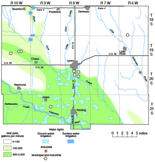
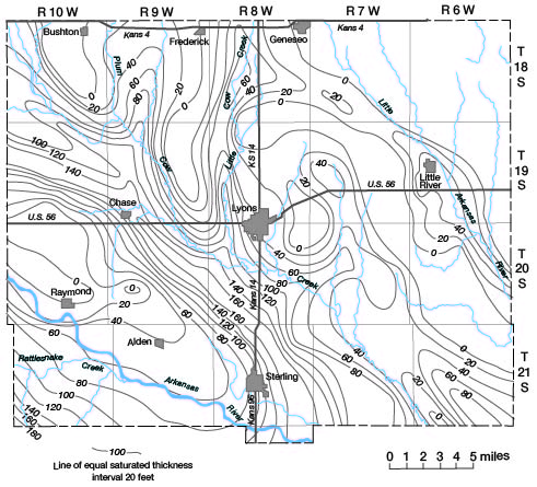
Figure 9 shows the saturated thickness of the unconsolidated deposits in Rice County. The buried early Pleistocene channel, where the saturated thickness is more than 160 feet, is clearly defined. Many irrigation wells obtain water from the saturated unconsolidated deposits in the major stream valleys. Only the upper 60 to 80 feet of these deposits generally is utilized. Water from the basal part of the deposits generally is of inferior quality where the saturated thickness exceeds 80 feet.
Figure 9--Saturated thickness of unconsolidated.
Movement of Water
Plate 1 indicates, by means of contours, the shape of the potentiometric surfaces for the Pleistocene and Cretaceous aquifers and the direction of movement of water in an area of about 70 square miles around Lyons. Each contour connects points of equal altitude of water level and, at any point along a contour, water moves downgradient at right angles to the contour. Data collected by Fent in 1946 and data collected in 1970 are shown on plate 1; however, the contours are based on the 1970 data. Depths to water in wells measured in 1946 were little different from the depths in the same or nearby wells measured in 1970. The water levels in wells in this area, which fluctuate with changing weather conditions, probably were much lower during the drought in the middle 1950's.
Water in loess in the upland areas moves generally southward except near the Little Arkansas River valley, where the direction of movement is eastward toward the valley.
Water moves outward from the center of the dune sand area in the southeastern part of the county. The slope of the water table is steep (as implied by the range in the altitudes of the water level), which indicates that considerable recharge occurs and that these deposits are somewhat less permeable than the alluvium and terrace deposits. In the dune sand tract in the west-central part of the county, the high altitudes of the water levels and the steepness of the slope of the water table are a reflection of the bedrock high in the area.
In the Pleistocene deposits of the Arkansas River and Cow Creek valleys, the slope of the water table is more uniform and is not as steep as in other areas. The water moves in an east-southeast direction except near the principal streams where it moves toward the streams.
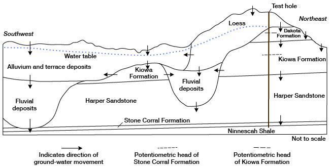
Water in the Pleistocene deposits is unconfined (water-table condition), and water in the bedrock aquifers is confined (artesian condition). When an artesian aquifer is penetrated by a drill hole, water will rise in the hole above the top of the aquifer. The generalized movement of ground water is shown on figure 10, which illustrates conditions near the city of Lyons. The potentiometric head in the bedrock units decreases with depth, allowing a slow downward movement of water through nearly impermeable confining layers. The potentiometric head in the Stone Corral Formation raises water in a well to a few feet above the base of the Kiowa Formation, and the head in the Kiowa raises water in a well above the base of the overlying aquifer. In the area north of Lyons, the head in the Kiowa Formation (determined by packer tests in wells) raises water to an altitude near that of the unconfined water table in loess overlying the Kiowa. In these tests, the potentiometric head in the Kiowa in nearly all wells was one or two feet below the water table in the overlying Pleistocene aquifer. If the head on the overlying aquifer is lowered significantly, water can move upward from a deeper aquifer with a greater head. Where the potentiometric head is sufficiently high, water can move laterally from the bedrock aquifer into adjacent Pleistocene deposits, and, conversely, if the potentiometric head is lowered sufficiently, water can move into the bedrock aquifer from the Pleistocene deposits. The normal direction of movement of water from precipitation is downward into both bedrock and Pleistocene aquifers, with subsequent lateral movement of ground water from the bedrock to the Pleistocene aquifers. Lowering the head in the Kiowa aquifer could, in time, reverse the direction of water movement in the entire aquifer system.
Figure 10--Generalized movement of ground water.
Prev Page--Geology || Next Page--Quality
Kansas Geological Survey, Geology
Placed on web Aug. 19, 2008; originally published April 1974.
Comments to webadmin@kgs.ku.edu
The URL for this page is http://www.kgs.ku.edu/General/Geology/Rice/04_gw.html