![]()
Prev Page--Contents || Next Page--Geology
Introduction
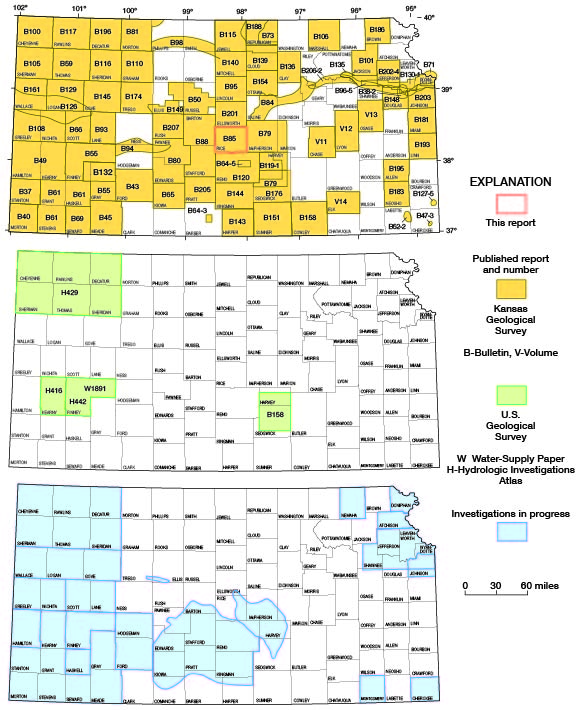
Rice County, in central Kansas (fig. 1), contains approximately 20 townships and is an area of 725 square miles. The area is in both the Dissected High Plains section of the Great Plains physiographic province and the Arkansas River Lowland section of the Central Lowlands province (Schoewe, 1949). Most of the county is drained by the Arkansas River and its tributaries, Cow Creek and Little Arkansas River. A few square miles in the northeast are drained by streams that are tributary to the Smoky Hill River.
Figure 1--Index map of Kansas showing area described in this report and areas covered by other online geologic reports, as of Aug. 2008. For additional information, please visit the KGS Geologic Maps of Kansas Page.
Rice County is on the western margin of the subhumid climatic zone. The area is characterized by a predominance of sunshine, moderate precipitation, and moderate wind velocity. At Alden the mean annual temperature is 56° F and the normal annual precipitation is 25.86 inches, based on National Weather Service (formerly U.S. Weather Bureau) records for the period 1898-1952. The station was moved to Sterling in 1953 and new normals have not been established. The average length of the growing season is 181 days.
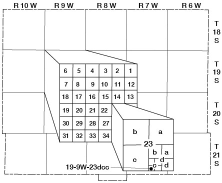
The well and test-hole numbers used in this report are given according to the U.S. Bureau of Land Management system of land division as follows: township, range, section, 160-acre tract or quarter section, 40-acre tract within the quarter section, and 10-acre tract within the quarter quarter section. As an example, well 19-9W-23dcc is in the SW SW SE sec. 23, T. 19 S., R. 9 W. (fig. 2).
Figure 2--Well-numbering system used in this report.
The area was originally studied by Fent (1950a). Many of the data in that report are used in this report. Data collected since that time, and especially data collected in the winter of 1970-71 during a study of the feasibility of using salt beds for storage of atomic wastes, are included in the present report.
Prev Page--Contents || Next Page--Geology
Kansas Geological Survey, Geology
Placed on web Aug. 19, 2008; originally published April 1974.
Comments to webadmin@kgs.ku.edu
The URL for this page is http://www.kgs.ku.edu/General/Geology/Rice/02_intro.html