![]()
Prev Page--Geology || Next Page--Ground water
Geologic Formations in Relation to Ground Water
Permian System--Sumner Group
Wellington Formation
The Wellington Formation crops out only in the southeastern part of the county but underlies younger rocks in the subsurface in the rest of the county. No test holes were drilled through the Wellington into the Chase Group, but lithologic characteristics indicate that the exposed section includes the lower part of the Wellington, and its thickness exceeds 50 feet.
The pre-Dakota erosional surface of the Wellington is irregular but exposures are few. In sec. 1, T. 12 S., R. 1 W., the surface is estimated to be 60 to 75 feet higher than nearby outcropping Dakota. The lower part of the Wellington consists mainly of bright-red and greenish-gray shale containing thin-bedded crystalline or, wavy-bedded impure limestone. The following section is typical of exposures of the Wellington Formation.
| Section of Wellington Formation on west creek bank in NE SE sec. 21, T. 12 S., R. 1 W., measured July 18, 1957. | Thickness, feet |
||
|---|---|---|---|
| Permian--Leonardian | |||
| Wellington Formation | |||
| Limestone, thin bedded, laminated; iron oxide stain | 0.2 | ||
| Shale, red and greenish gray, mottled | 8.3 | ||
| Limestone, thin bedded, light brown | 0.2 | ||
| Shale, red and green, mottled, platy | 2.8 | ||
| Shale, grayish green; thin, wavy-bedded light-brown limestone | 1.2 | ||
| Shale, dull red and grayish green, mottled, blocky to platy | 3.6 | ||
| Shale, black, blocky | 0.2 | ||
| Shale, light and dark gray, silty | 1.0 | ||
| Shale, black and dark brown, blocky, silty | 1.0 | ||
| Total thickness measured | 18.5 | ||
Water supply--No wells are known to derive water from the Wellington Formation. Its permeability is so low that it serves as a nearly impermeable boundary below water-bearing formations. Water in the upper part is strongly mineralized. Two wells that tap an overlying aquifer but penetrate or come in contact with the Wellington are in the NE NE NE sec. 18, T. 11 S., R. 1 W., and the SE NE SE sec. 10, T. 12 S., R. 3 W. Both yield water that is hard and contains much sulfate; water from the second well also contains much chloride.
Cretaceous System
Kiowa Shale
The Kiowa Shale crops out only in isolated patches in southeastern and eastern Ottawa County. It is in the subsurface in the rest of the county except in the northeastern part, where it pinches out and the Dakota lies directly on the Permian, and in the southeastern part where Permian rocks are at the surface. Test holes in the northwest part of the county penetrated 80 feet of Kiowa without reaching the Wellington. An additional 20 to 40 feet might be expected.
The Kiowa is predominantly a gray fissile marine shale containing thick zones of gray siltstone along the eastern boundary. The predominant clay mineral in the shale is illite. Thin zones of fine sand are in the subsurface to the west. Gypsum and pyrite are common. Pelecypods (Cardium, Corbula, Exogyra, Gryphaea, Mactra, Ostrea, Pecten, Trigonia) in nearby counties have been reported by Twenhofel (1924). Gastropods are represented by Turritella. Cephalopods, brachiopods, coelenterates, and annelids have also been reported by Twenhofel.
The following measured sections of Kiowa illustrate basic similarities, even though there are some differences.
| Section of Kiowa Shale on south bank of Solomon River in NE NE NW sec. 19, T. 12 S., R. 2 W., measured August 7, 1958. | Thickness, feet |
||
|---|---|---|---|
| Cretaceous | |||
| Dakota Formation | |||
| Sandstone, light brown, friable, tabular, cross bedded in part; fine to medium quartzose sand, some solution holes, linear iron oxide stain | 15.0 | ||
| Sandstone, reddish brown; fine to coarse quartzose sand, thin lignitic zones, pyrite, coarse conglomerate on uneven base | 5.0 | ||
| Disconformity | |||
| Kiowa Shale | |||
| Shale, black, fissile, weathers with white coating, not present continuously; abundant euhedral gypsum crystals; cone-in-cone near center | 3.9 | ||
| Siltstone, medium gray, blocky; much clay toward top, pyrite, iron oxide stain | 7.0 | ||
| Siltstone, medium to light gray, blocky, resistant near top; fine black laminations; pyrite | 4.5 | ||
| Siltstone, medium to light gray, resistant; surficial iron oxide stain | 0.7 | ||
| Siltstone, medium gray; localized pyrite | 2.9 | ||
| Siltstone, light gray, resistant; surficial iron oxide stain | 0.9 | ||
| Siltstone, medium gray, blocky | 4.8 | ||
| Siltstone, light gray, blocky | 5.3 | ||
| Siltstone, medium gray; locally contains fine black laminations and some small lenses of very fine sand, iron oxide stain | 11.7 | ||
| Total thickness measured | 61.7 | ||
| Section of Kiowa Shale exposed in ravine at cen. W. line, sec. 10, T. 11 S., R. 1 W., measured July 16, 1957. | Thickness, feet |
||
|---|---|---|---|
| Cretaceous | |||
| Kiowa Shale | |||
| Siltstone, light brown, variegated; iron oxide stain | 2.4 | ||
| Shale, medium gray, fissile to blocky | 4.0 | ||
| Shale, black, fissile | 1.0 | ||
| Siltstone, white; fine laminations | 0.3 | ||
| Shale, clayey, black | 1.8 | ||
| Clay; contains concretions cemented with iron oxide | 0.6 | ||
| Shale, black, fissile | 1.5 | ||
| Shale, clayey, gray | 0.5 | ||
| Siltstone, light brown, mottled with dark brown | 0.3 | ||
| Shale, black, fissile | 0.6 | ||
| Shale, medium brown, blocky | 1.8 | ||
| Shale, black, fissile | 4.8 | ||
| Siltstone, light gray, weathers white; gypsum crystals | 0.2 | ||
| Shale, black, fissile; contains iron oxide at base | 0.6 | ||
| Shale, black, fissile | 0.8 | ||
| Shale, gray, blocky | 0.4 | ||
| Shale, black, fissile; gypsum crystals | 1.1 | ||
| Shale, clayey, medium gray | 0.6 | ||
| Shale, black, blocky | 1.5 | ||
| Shale, gray, fissile; contains iron stain along fissure planes, gypsum crystals | 5.4 | ||
| Total thickness measured | 30.2 | ||
| Section of Kiowa Shale exposed on south side of ravine southeast of hill in SW NW SE sec. 11, T. 10 S., R. 1 W., measured August 10, 1958. | Thickness, feet |
||
|---|---|---|---|
| Cretaceous | |||
| Dakota Formation | |||
| Clay, light gray, blocky; red and yellow stain, irregular gypsum crystals, | 8.0 | ||
| Clay, dark to medium brown, streaked yellow, indurated; lignite and plant fossil fragments | 1.5 | ||
| Clay, light gray and brown, mottled; iron oxide stain spotted throughout, lignite near top | 2.3 | ||
| Sandstone, light brown, medium grained, quartzose, well sorted, friable; iron oxide stain, faint cross bedding near top | 5.5 | ||
| Siltstone, clayey, medium to light gray; grades to fine sandstone near top | 3.0 | ||
| Disconformity | |||
| Kiowa Shale | |||
| Shale, black, fissile, nonfossiliferous, carbonaceous; cone-in-cone at base, | 0.3 | ||
| Shale, medium gray, fissile; iron-stain streaks | 7.8 | ||
| Shale, medium gray, blocky grading to fissile, iron stained along joints; medium-gray, finely crystalline limestone 0.2 foot thick at top | 3.8 | ||
| Shale, medium gray, fissile to blocky, iron stained along joints; medium-gray, finely crystalline limestone 0.2 foot thick at top | 2.0 | ||
| Total thickness measured | 34.2 | ||
Water supply--The Kiowa Shale is not known to yield water to wells in Ottawa County, but some strongly mineralized water containing much calcium and sulfate may come from thin sandstone layers in wells in the SE NW NE sec. 9, and in the SE SE SW sec. 11, T. 12 S., R. 4 W.
Dakota Formation
The Dakota Formation is exposed in much of Ottawa County and thereby forms the basis for the topography. The Dakota unconformably overlies either Wellington Formation or Kiowa Shale in the southeastern part of the county, and it is conformably overlain by Graneros Shale in the northwest, where test holes show that the Dakota is as much as 350 feet thick. The thickness is not uniform, however, because of the basal unconformity.
In Ottawa County, the Dakota Formation consists of three intergrading units. The upper and lower hundred feet are chiefly massive lenticular sandstone interbedded with lenticular silt and clay. The middle 100 to 150 feet is lenticular silt and clay interbedded with lenticular sand. Deep test holes, numerous outcrops, and general topography provide evidence for this interpretation. Lenticularity of all beds prevents correlation of any bed for a distance greater than a few miles. Local disconformities are numerous throughout the section.
Clays of the Dakota are kaolinitic. They may be red, yellow, blue, gray, black, or white. Red and gray mottled clay is restricted to and very abundant throughout the lower two-thirds of the section. Most soft light-brown siltstone near the base and top of the section is bedded; where it is not bedded, it may grade into clay.
The Dakota is best known for its sandstone, which constitutes only 25 to 40 percent of the formation. Quartz sandstone case hardened by iron oxide cement forms a resistant cap on small mesas. Generally, the sandstones are composed of well-sorted, poorly consolidated, fine and medium quartzose sand. Cross beds are abundant and dip in an average direction of S 57° W (Franks and others, 1959).
Several sandstone samples were analyzed mechanically and statistically by Paul Franks and George Coleman. The results are summarized in Table 3.
Table 3--Summary of mechanical and statistical analyses of grab samples of sandstone in Dakota Formation, Ottawa County. Analyzed by Paul Franks and George Coleman. Averages for all samples: Median diameter--0.23 mm; quartile diameter--0.04 mm; per. centile 10/90 diameter--0.11 mm. *Retained on screen of this mesh opening.
| Sample | NE sec. 14, T. 11 S., R. 2 W. |
NW sec. 26, T. 9 S., R. 5 W. |
NE sec. 19, T. 12 S., R. 2 W. |
SE sec. 20, T. 10 S., R. 4 W. |
Sec. 34, T. 9 S., R. 2 W. |
|||||
|---|---|---|---|---|---|---|---|---|---|---|
| Size* (mm) | Percent of whole |
Cum. percent |
Percent of whole |
Cum. percent |
Percent of whole |
Cum. percent |
Percent of whole |
Cum. percent |
Percent of whole |
Cum. percent |
| 2.000 | ||||||||||
| 1.000 | 0.05 | 0.05 | 2.42 | 2.42 | ||||||
| 0.840 | 0.11 | 0.16 | 0.01 | 0.01 | 3.02 | 5.44 | ||||
| 0.710 | 0.52 | 0.68 | 0.03 | 0.04 | 6.30 | 11.74 | ||||
| 0.589 | 1.62 | 2.30 | 0.21 | 0.25 | 6.84 | 18.58 | ||||
| 0.500 | 0.02 | 0.02 | 0.01 | 0.01 | 4.42 | 6.72 | 0.29 | 0.54 | 11.57 | 30.15 |
| 0.417 | 0.01 | 0.03 | 0.01 | 0.02 | 5.49 | 12.21 | 0.37 | 0.91 | 12.86 | 43.01 |
| 0.350 | 0.03 | 0.06 | 0.01 | 0.03 | 13.08 | 25.29 | 0.66 | 1.57 | 24.20 | 67.21 |
| 0.295 | 0.25 | 0.31 | 0.04 | 0.07 | 32.19 | 57.48 | 1.03 | 2.60 | 17.34 | 84.55 |
| 0.250 | 8.48 | 8.79 | 0.12 | 0.19 | 28.11 | 85.59 | 1.69 | 4.29 | 4.07 | 88.62 |
| 0.210 | 29.62 | 38.41 | 0.24 | 0.43 | 4.73 | 90.32 | 1.69 | 5.98 | 0.36 | 88.98 |
| 0.175 | 41.08 | 79.49 | 1.80 | 2.23 | 4.26 | 94.58 | 3.80 | 9.78 | 1.28 | 90.26 |
| 0.149 | 14.69 | 94.18 | 16.63 | 18.86 | 1.97 | 96.55 | 23.59 | 33.37 | 0.99 | 91.25 |
| 0.125 | 1.86 | 96.04 | 22.64 | 41.50 | 0.80 | 97.35 | 23.22 | 56.59 | 0.68 | 91.93 |
| 0.105 | 1.09 | 97.13 | 24.04 | 65.54 | 0.66 | 98.01 | 21.08 | 77.67 | 0.94 | 92.87 |
| 0.088 | 0.50 | 97.63 | 12.52 | 78.06 | 0.28 | 98.29 | 7.62 | 85.29 | 0.60 | 93.47 |
| 0.074 | 0.63 | 98.26 | 10.93 | 88.99 | 0.34 | 98.63 | 6.33 | 91.61 | 1.18 | 94.65 |
| 0.062 | 0.30 | 98.56 | 3.74 | 92.73 | 0.18 | 98.81 | 1.63 | 93.24 | 0.69 | 95.34 |
| pan | 1.43 | 99.99 | 7.27 | 100.00 | 1.19 | 100.00 | 6.75 | 99.99 | 4.66 | 100.00 |
| Median diameter (mm) |
0.201 | 0.118 | 0.31 | 0.157 | 0.405 | |||||
| Quartile diameter (mm) |
0.024 | 0.024 | 0.046 | 0.030 | 0.047 | |||||
| Percentile 10/90 diameter (mm) |
0.060 | 0.045 | 0.117 | 0.051 | 0.280 | |||||
| Sample | Sec. 31, T. 11 S., R. 2 W. |
Sec. 33, T. 11 S., R. 3 W. |
Sec. 2 and 11, T. 11 S., R. 1 W. |
Sec. 8 and 9, T. 12 S., R. 5 W. |
Sec. 28, T. 12 S., R. 5 W. |
Sec. 19, T. 12 S., R. 5 W. |
||||||
|---|---|---|---|---|---|---|---|---|---|---|---|---|
| Size* (mm) | Percent of whole |
Cum. percent |
Percent of whole |
Cum. percent |
Percent of whole |
Cum. percent |
Percent of whole |
Cum. percent |
Percent of whole |
Cum. percent |
Percent of whole |
Cum. percent |
| 2.000 | 1.86 | 1.856 | ||||||||||
| 1.000 | 6.32 | 8.18 | 0.01 | 0.01 | ||||||||
| 0.840 | 4.23 | 12.41 | 0.01 | 0.02 | 0.01 | 0.01 | ||||||
| 0.710 | 8.23 | 20.64 | 0.13 | 0.15 | 0.01 | 0.01 | 0.01 | 0.02 | 0.01 | 0.01 | ||
| 0.589 | 10.64 | 31.28 | 0.23 | 0.38 | 0.01 | 0.02 | 0.02 | 0.04 | 0.01 | 0.01 | 0.02 | 0.03 |
| 0.500 | 25.82 | 57.10 | 0.44 | 0.82 | 0.02 | 0.04 | 0.05 | 0.09 | 0.02 | 0.03 | 0.04 | 0.07 |
| 0.417 | 22.83 | 79.93 | 0.37 | 1.19 | 0.02 | 0.06 | 0.03 | 0.12 | 0.02 | 0.05 | 0.02 | 0.09 |
| 0.350 | 9.16 | 89.09 | 1.35 | 2.54 | 0.06 | 0.12 | 0.09 | 0.21 | 0.05 | 0.10 | 0.14 | 0.23 |
| 0.295 | 1.01 | 90.10 | 3.42 | 5.96 | 0.12 | 0.24 | 0.35 | 0.56 | 0.15 | 0.25 | 1.02 | 1.25 |
| 0.250 | 0.55 | 90.65 | 11.79 | 17.75 | 0.67 | 0.91 | 6.23 | 6.79 | 1.52 | 1.77 | 10.91 | 12.16 |
| 0.210 | 0.08 | 90.73 | 15.21 | 32.96 | 6.70 | 7.61 | 21.55 | 28.34 | 4.16 | 5.93 | 23.64 | 35.80 |
| 0.175 | 0.55 | 91.28 | 22.82 | 55.78 | 42.73 | 50.34 | 40.01 | 68.35 | 11.44 | 17.37 | 42.65 | 78.45 |
| 0.149 | 0.46 | 91.84 | 22.02 | 77.80 | 33.88 | 84.22 | 19.40 | 87.75 | 24.67 | 42.04 | 15.65 | 94.10 |
| 0.125 | 0.23 | 92.07 | 11.19 | 88.99 | 8.14 | 92.36 | 4.54 | 92.29 | 24.93 | 66.97 | 1.95 | 96.05 |
| 0.105 | 0.43 | 92.50 | 5.19 | 94.18 | 2.68 | 95.04 | 2.80 | 95.09 | 16.62 | 83.59 | 1.00 | 97.05 |
| 0.088 | 0.35 | 92.85 | 1.17 | 95.35 | 1.21 | 96.25 | 1.02 | 96.11 | 6.74 | 90.33 | 0.45 | 97.50 |
| 0.074 | 0.88 | 93.74 | 1.46 | 96.81 | 1.30 | 97.55 | 0.86 | 96.97 | 4.82 | 95.15 | 0.60 | 98.10 |
| 0.062 | 0.61 | 94.34 | 0.25 | 97.06 | 0.35 | 97.90 | 0.58 | 07.55 | 1.07 | 96.22 | 0.19 | 98.29 |
| pan | 5.66 | 100.00 | 2.94 | 100.00 | 2.10 | 100.00 | 2.45 | 100.00 | 3.78 | 100.00 | 1.71 | 100.00 |
| Median diameter (mm) |
0.54 | 0.183 | 0.179 | 0.190 | 0.140 | 0.200 | ||||||
| Quartile diameter (mm) |
0.100 | 0.067 | 0.021 | 0.032 | 0.027 | 0.023 | ||||||
| Percentile 10/90 diameter (mm) |
0.29 | 0.078 | 0.035 | 0.057 | 0.053 | 0.050 | ||||||
The lithology, depositional environment, and water-bearing properties of sandstone in the Dakota Formation were studied from sections of several representative samples.
A photomicrograph of a thin section of typical iron oxide cemented cap rock that covers the mesas is shown in Plate 3A. The sample is from the SE SE SE sec. 11, T. 9 S., R. 1 W. Paul Franks, who made petrographic examinations of the sandstone samples, provided the following statements:
The rock is a light-brown to grayish-brown (5 YR 5/6 to 5 YR 3/2) and grayish red-purple (5 RP 4/2), medium-grained, iron oxide enriched sandstone that has "limonite"-walled tubular cavities measuring as much as 6 mm in diameter. The "limonite" walls of the cavities are as much as 1.5 mm thick.
In thin section, angular to well-rounded quartz grains, which constitute about 80 percent of the rock, are embedded in a matrix of "limonite" that contains birefringent goethite(?). The sections contain less than 1 percent feldspar and mica and only traces of tourmaline and staurolite in detrital grains. Most of the angular detrital grains have sutured margins; quartz overgrowths are uncommon.
Plate 3--Photomicrographs of thin sections of samples of typical sandstone in Dakota Formation in Ottawa County, plane-polarized light, x 123. [Photos enlarged for web version and magnification recalculated.] A, iron oxide-cemented cap rock from SE SE SE sec. 11, T. 9 S., R. 1 W. Black areas are opaque "limonite." B, Massive channel sandstone from SW NW NW sec. 1, T. 9 S., R. 1 W. Black areas are clay matrix, some of which is entrapped in silica overgrowths on quartz grains.
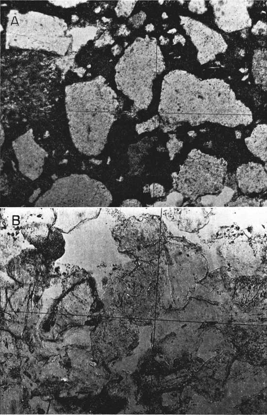
Plate 3B is a photomicrograph of thin-section cut normal to the bedding of a typical massive channel sandstone body in the SW NW NW sec. 1, T. 9 S., R. 1 W.
The rock is a light grayish-orange (10 YR 8/4), fine- to medium-fine-grained sandstone that shows only faint indication of bedding or lamination. Minute light-gray argillaceous specks may be weathered feldspar.
In thin section, the rock is seen to be composed mainly of detrital quartz grains embedded in a clay matrix that is stained by iron oxide. Bedding is indicated by slight tendency for subparallel alignment of long axes of detrital grains. The quartz grains constitute more than 90 percent of the rock, are slightly rounded, and many have overgrowths, but the overgrowths commonly do not surround the grains completely. Long diameters of the quartz grains range from 0.04 to 0.84 mm. The quartz grains locally are coated with leucoxene. In addition to quartz, the detrital grains include 1 or 2 percent feldspar, some of which is fresh; traces of muscovite as shredded books; 1 percent detrital chert and schist fragments; and traces of tourmaline, staurolite, and leucoxene. The clay matrix constitutes less than 5 percent of the rock but surrounds each detrital grain as a thin film; it fills pore spaces only locally.
The cellular sandstone (Pl. 4A), which is from a rock similar in appearance to scoria in the NW SW NW sec. 25, T. 11 S., R. 4 W., consists of silty clay pellets surrounded by iron oxide cemented sand. The clay near the surface is removed by weathering, which causes the rock to appear scoriaceous.
The rock is cellular, iron oxide enriched sandstone in which the pits measure as much as 8 mm in long diameter, are roughly ovoid, and on fresh fractures are filled with silty ferruginous clay. Color on weathered surface is reddish purple (5 RP 4/2); on fresh surface, light brown to moderate-reddish brown (5 YR 6/4 to 10 R 4/6).
In thin section, the rock is seen to be similar to the type described by Swineford (1947). Large ovoid pockets (0.5 to 8 mm in long diameter) are separated by a "limonite" and hematite matrix that includes numerous quartz grains and may contain birefringent goethite. The matrix constitutes approximately 40 percent of the rock. The included quartz grains, constituting about 40 percent of the matrix, range in long diameter from 0.02 to 0.7 mm; some are well rounded, but most have sutured margins. The matrix contains less than 1 percent detrital feldspar grains and muscovite shreds. The ovoids are filled with illitic(?) clay that is stained brown by iron oxide and with silt-size quartz grains (0.01 to 0.12 mm in long diameter). Quartz constitutes approximately 20 percent of the ovoids, which probably are clay pellets.
Plate 4--Photomicrographs of thin sections of typical sandstone in Dakota Formation, plane-polarized light, x 123. [Photos enlarged for web version and magnification recalculated.] A, cellular iron oxide-enriched sandstone in NW SW NW sec. 25, T. 11 S., R. 4 W. Black areas are mainly "limonite" and hematite. B, Calcite-cemented sandstone concretion in NW SW NW sec. 30, T. 12 S., R. 5 W.
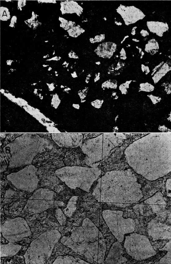
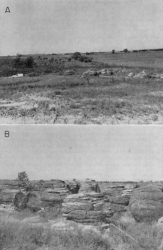
An examination of a thin section of a sample from a concretion (Pl. 4B) in the NW SW NW sec. 30, T. 12 S., R. 5 W., and similar to those in "Rock City", near Lamar, and other places in Ottawa County indicates that most of the quartz grains are separated by calcite cement. Formation of the concretions was described by Schoewe (1937). Mineralized water, flowing through well-sorted sand, supplied calcium and bicarbonate ions that precipitated as calcium carbonate (calcite) around a core, either organic or inorganic, that was compatible for its precipitation. Once the precipitation had started, it continued concentrically in the homogeneous sand as long as calcium and bicarbonate ions were available in sufficient concentration. Subsequent to their formation, the concretions have been exposed by the removal of the material around them in "Rock City" and Lamar (Pl. 5). Other concretions in the county are partly or wholly covered. According to Franks:
The rock from the NW SW NW sec. 30, T. 12 S., R. 5 W., is a light brownish-gray (5 YR 7/1) sandstone that has dark-gray (N 3) stain on fracture or bedding surfaces. It is very fine to fine grained and cemented with calcite. The calcite seemingly is in large crystalline grains as much as 1 cm in diameter. The rock breaks along the calcite cleavage directions.
In thin section, the rock is similar to those described by Swineford (1947) and is composed mainly of detrital quartz grains set in calcite cement. Bedding is indicated by subparallel alignment of the long axes of the detrital grains, which approximate 55 percent of the rock and include, in addition to quartz, chert (1 percent), feldspar (1 percent), sphene (trace), and zircon (trace). The quartz grains are much sutured and embayed by the calcite cement, show no overgrowths, and measure 0.08 to 0.60 mm along their long diameters. The calcite cement occurs as optically continuous patches that are sieved by the detrital grains, measure as much as 1 cm in diameter, and approximate 45 percent of the rock.
Plate 5--Sandstone concretions in Dakota Formation. A, "Rock City" in the SE SE SW sec. 14, T. 11 S., R. 4 W. B, "Rock City" concretions showing cross bedding.
The following measured sections give almost a complete section of the Dakota Formation in the general area along U. S. Highway 81 south of Solomon River from sec. 14 to sec. 36, T. 12 S., R. 3 W.
| Section of Dakota Formation exposed on east side of U. S. Highway 81 at base of radio tower in NW sec. 36, T. 12 S., R. 3 W. Altitude about 1,400 feet. | Thickness, feet |
||
|---|---|---|---|
| Cretaceous | |||
| Dakota Formation | |||
| Sandstone, dark brown, hard; medium to coarse well-rounded quartzose grains, iron oxide cement; rests on disconformity--a channel sandstone | 2-3.5 | ||
| Clay, silty, medium gray, more silty at top, weathers light gray; no apparent bedding | 8.0+ | ||
| Section of Dakota Formation exposed on west side U. S. Highway 81 at large road cut in SE NE SE sec. 26, T. 12 S., R. 3 W. Altitude about 1,390 feet. | Thickness, feet |
||
|---|---|---|---|
| Shale, dark red, clayey, blocky; contains light-brown clay zones | 3.0 | ||
| Silt, sandy, light brown, limonitic, hard | 0.5 | ||
| Clay, medium gray, not bedded; streaked iron oxide stains | 4.8 | ||
| Silt, clayey, yellow brown | 1.1 | ||
| Clay, dark brown; small fragments of plant fossils | 2.0 | ||
| Clay, medium to dark gray, blocky; iron oxide stains | 5.8 | ||
| Clay, dark red | 1.8 | ||
| Clay, medium to light gray; dark red and brown stains | 2.6 | ||
| Siltstone, light brown, poorly bedded, resistant | 1.8 | ||
| Clay, light to dark gray, silty; slight iron oxide stain | 4.8 | ||
| Clay, greenish gray, dark red, and brown, mottled | 6.8 | ||
| Clay, light gray; light-brown mottling, abundant selenite crystals | 5.5 | ||
| Siltstone, light brown, resistant; iron oxide cement | 0.5 | ||
| Section of Dakota Formation on east side of U. S. Highway 81 at small road cut in cen. W. line sec. 25, T. 12 S., R. 3 W. Altitude about 1,350 feet. | Thickness, feet |
||
|---|---|---|---|
| Clay, medium gray, silty; contains dark-red, brown, and gray clay | 5.0 | ||
| Sand, light brown, fine to medium grained; iron oxide stain | 1.5 | ||
| Clay, medium ,ray, silty, laminated | 2.3 | ||
| Siltstone, medium gray; contains iron-stained zones of clay; plant fragments near center | 2.3 | ||
| Clay, dark grayish brown, silty; contains numerous lignite fragments, sparser toward top | 4.3 | ||
| Clay, medium gray, blocky | 2.5 | ||
| Section of Dakota Formation on west side of U. S. Highway 81 at small road cut in SE SE NE sec. 26, T. 12 S., R. 3 W. Altitude about 1,330 feet. | Thickness, feet |
||
|---|---|---|---|
| Sandstone, light brown, tabular, resistant | 1.0 | ||
| Sandstone, very light brown, well sorted; some iron oxide stain; partly covered | 5.0 | ||
| Sandstone, light brown; hard hematite zones near top; mostly covered | 5.0 | ||
| Sandstone, light brown, fine grained, poorly consolidated, massive; cross beds at top and bottom, liesegang rings at top; variable iron oxide stain | 13.0 | ||
| Section of Dakota Formation on west side of U. S. Highway 81 at small road cut in SE NE SE sec. 23, T. 12 S., R. 3 W. Altitude about 1,300 feet. | Thickness, feet |
||
|---|---|---|---|
| Sandstone, yellowish brown, well sorted, very fine to fine grained, angular, quartzose; iron oxide stain; channel sand overlain by hard, fine conglomerate. Laterally grades into light-brownish-gray silty clay containing fragments of plant fossils (where above channel sand is absent) | 1.5 | ||
| Sandstone, variegated, massive, angular, medium grained, quartzose | 5.0 | ||
| Sandstone, medium yellowish brown, massive, very fine to fine grained, subhedral to anhedral, quartzose | 6.0+ | ||
| Section of Dakota Formation on west side of U. S. Highway 81 at road cut in NE SE NE sec. 14, T. 12 S., R. 3 W. Altitude about 1230 feet. | Thickness, feet |
||
|---|---|---|---|
| Clay, silty, light gray and yellow brown; some fine sand | 6.0+ | ||
| Silt, medium yellowish brown, platy bedding; some fine sand | 0.8 | ||
| Shale, clayey, medium gray, silty; sharp bedding planes | 5.0 | ||
| Sandstone, variegated, red, yellow, gray, brown, white, poorly consolidated to friable; 1- to 4-foot beds | 25.0 | ||
| Total thickness measured | 220.0 | ||
About 20 feet of basal Dakota is not exposed, and about 90 feet of uppermost Dakota has been eroded from the top of this section.
| Section of Dakota Formation along creek in SE SW sec. 14, T. 9 S., R. 5 W. | Thickness, feet |
||
|---|---|---|---|
| Cretaceous | |||
| Graneros Shale | |||
| Shale, dark gray, laminated | 1.0 | ||
| Dakota Formation | |||
| Clay, medium gray and yellow; mostly covered | 24.6 | ||
| Shale, clayey, medium gray, fissile, soft, weathers light gray | 8.0 | ||
| Sandstone, white, unconsolidated, fine to medium grained; capped with 0.2 foot of sandstone cemented by iron oxide | 2.0 | ||
| Covered | 3.5 | ||
| Siltstone, light yellow; gray sandy clay | 0.7 | ||
| Siltstone, light brown, laminated; iron oxide cement | 0.7 | ||
| Clay, light and dark gray, streaked yellow; mostly covered | 10.5 | ||
| Sandstone, light gray; hard iron oxide cap that is 0.2 foot thick | 0.8 | ||
| Clay, gray, stained yellow; mostly covered | 4.7 | ||
| Sandstone, light brown, medium to fine grained, poorly consolidated; iron concretions near base, cross beds near top | 7.0+ | ||
| Total thickness measured | 56.5 | ||
There are numerous small outcrops of Dakota in Ottawa County, but most of them are sandstone that is similar to that described and do not have any stratigraphic significance.
Water supply--All wells in Ottawa County that do not obtain water from Pleistocene deposits are finished in the Dakota Formation. Stock wells yield 1 to 5 gpm (gallons per minute), but one industrial well, in sec. 34, T. 11 S., R. 5 W., yields 145 gpm. The dissolved solids range from about 100 to 2,000 ppm. The water in most places is hard and contains enough iron to stain laundry and plumbing. The amount of dissolved sulfate differs considerably, but chloride content of most samples is small.
Several wells are dug, but most are drilled. The deepest known drilled water well in the county is 177 feet deep. Successful wells can be drilled most places in the Dakota Formation. In some places no sand is encountered, but this situation is rare. The hydrologic properties of the Dakota Formation are discussed [in the State Lake aquifer test].
Graneros Shale
Except for two small localities in southwestern Ottawa County, the Graneros Shale is confined to the northwest, where a cover of Greenhorn Limestone protects it from rapid erosion. Colluvial cover makes natural outcrops uncommon. The Graneros Shale is about 38 feet thick and is conformable, below and above, with the Dakota Formation and the Greenhorn Limestone, respectively. Its distinctive lithology, relatively uniform thickness, and wide distribution make the Graneros Shale a good marker bed for drillers.
The Graneros Shale is composed chiefly of black fissile shale, noncalcareous except somewhat calcareous near the top. Thin limestone beds, scattered through the section, are more abundant near the base. Thin beds of bentonite are common throughout the section.
The following exposed section was measured within a quarter of a mile from a test hole drilled for surface-subsurface correlation.
| Section of Graneros Shale along steep stream bed on east side of road in sec. 14, T. 9 S., R. 5 W., measured July 11, 1958. | Thickness, feet |
||
|---|---|---|---|
| Cretaceous | |||
| Greenhorn Limestone | |||
| Limestone, gray, dense to fine grained, fossiliferous | 0.3 | ||
| Graneros Shale | |||
| Shale, black to dark gray, calcareous; 0.2-foot yellow-stained bentonite bed near top | 3.0 | ||
| Shale, black, fissile; 0.2-foot bentonite beds at top and bottom | 1.0 | ||
| Shale, black, fissile, slightly calcareous; two 0.2-foot gray crystalline limestone beds near top; pelecypods abundant | 5.2 | ||
| Shale, black, fissile; two 0.1-foot bentonite beds 0.2 foot apart near top | 3.0 | ||
| Shale, black, fissile, noncalcareous; 0.3-foot bentonite bed at top | 1.2 | ||
| Shale, black, fissile; 0.2-foot bentonite bed at top | 1.2 | ||
| Shale, limy, and shaly limestone, dark brown, soft | 1.2 | ||
| Shale, black, fissile, weathers light gray | 1.4 | ||
| Shale, limy, dark brown, soft, carbonaceous; 0.4-foot yellow-stained white bentonite near top | 3.0 | ||
| Limestone, platy, medium grained crystalline | 1.2 | ||
| Shale, black, fissile; partly covered | 11.2 | ||
| Limestone, platy, medium grained crystalline | 0.8 | ||
| Shale, dark gray and brown, laminated, fissile | 2.8 | ||
| Limestone, platy, medium brown, medium grained crystalline | 0.7 | ||
| Bentonite, yellowish white | 0.5 | ||
| Shale, dark gray, laminated | 1.0 | ||
| Dakota Formation | |||
| Clay, gray and yellow; streaks of iron stain | 21.6 | ||
| Total thickness measured | 60.2 | ||
Water supply--The Graneros Shale is not known to yield water to wells in Ottawa County. A small amount of mineralized water seeping down from the Graneros through fissures and joints into the Dakota Formation probably affects the quality of the underlying Dakota water.
Greenhorn Limestone
The Greenhorn Limestone has almost the same distribution as the Graneros Shale--two small areas in the southwestern part of the county and the hilly area in the northwest. The Greenhorn Limestone is conformable with the Graneros Shale below and with the Carlile Shale above. The Greenhorn is about 75 feet thick where it is overlain by the Carlile Shale.
The Greenhorn Limestone is chalky except for some crystalline limestone and some bentonite beds. The chalky limestone and chalky "shale" are reported to have the same percentage of CaO (Norman Plummer, personal communication). Some of the limestone beds are composed almost entirely of fossils--mostly oysters, such as Inoceramus labiatus, and foraminifera, such as Globigerina (Stanton, 1922). The "Fencepost" Limestone bed, which is about half a foot thick and easily identified by an iron-stained zone in the middle, does not crop out commonly in Ottawa County.
The following measured section was made above the section of Graneros Shale given [previously].
| Section of Greenhorn Limestone on east side of road in sec. 14, T. 9 S., R. 5 W., measured July 11, 1958. | Thickness, feet |
||
|---|---|---|---|
| Cretaceous | |||
| Greenhorn Limestone | |||
| Limestone, light grayish brown, medium grained, wavy bedded; pelecypods | 0.3 | ||
| Limestone, shaly, light brown, chalky, papery | 1.0 | ||
| Limestone, light brown, coarse grained; fossiliferous | 0.2 | ||
| Limestone, shaly, light grayish brown, chalky, platy to tabular | 1.7 | ||
| Limestone, grayish brown, coarse grained, hard, fossiliferous | 1.1 | ||
| Limestone, shaly, light grayish brown, chalky, laminated, platy | 1.1 | ||
| Limestone, light grayish brown, laminated | 0.2 | ||
| Limestone, shaly, light brownish gray, chalky; contains crystalline limestone zones | 1.4 | ||
| Limestone, light grayish brown, hard; pelecypods | 0.4 | ||
| Limestone, shaly, light brownish white, chalky; oyster bed | 1.0 | ||
| Limestone, light grayish brown, hard; oysters on base | 0.4 | ||
| Limestone, shaly, light grayish brown, chalky, very fossiliferous | 0.8 | ||
| Limestone, light brown, hard, even bedded; contains iron oxide streak in center, abundant fossils | 0.5 | ||
| Limestone, shaly, light grayish brown, chalky, very fossiliferous | 0.5 | ||
| Limestone, light gray, chalky, fossiliferous | 0.4 | ||
| Limestone, light grayish tan, chalky, very fossiliferous | 0.7 | ||
| Limestone, light gray, chalky | 0.3 | ||
| Limestone, shaly, very light gray, chalky, finely laminated | 0.6 | ||
| Limestone, very light brownish gray, powdery, fossiliferous | 0.4 | ||
| Limestone, shaly, light gray, papery, chalky | 1.6 | ||
| Limestone, very light gray, dense to powdery, weathers light brown | 0.6 | ||
| Limestone, shaly, light gray; iron oxide stain | 1.4 | ||
| Limestone, shaly, light grayish brown, finely laminated; 0.2-foot chalky limestone at top | 1.0 | ||
| Limestone, shaly, light grayish brown; finely laminated 0.7-foot bed of light-gray, dense to chalky limestone at top | 1.4 | ||
| Limestone, light gray, chalky | 0.3 | ||
| Limestone, shaly, light gray, papery | 0.4 | ||
| Limestone, light gray, dense to chalky; iron oxide stain | 0.3 | ||
| Shale, medium gray, calcareous, papery, stained yellow, thin lenses of fissile black shale | 2.3 | ||
| Shale, light gray, calcareous, platy | 3.4 | ||
| Shale, black, fissile, carbonaceous | 0.5 | ||
| Shale, grayish brown, calcareous, papery | 0.5 | ||
| Bentonite; yellowish stain | 0.2 | ||
| Limestone, shaly, light gray, platy | 3.0 | ||
| Limestone, medium gray, fine grained, dense, fossiliferous | 0.3 | ||
| Graneros Shale | |||
| Total thickness measured | 30.2 | ||
Water supply--No wells in Ottawa County are known to obtain water from the Greenhorn Limestone. Although there is some jointing, no known water supplies are obtained from the joint system. Wells drilled in this area extend to the Dakota Formation for dependable yield.
Carlile Shale
The Carlile Shale is present only in the northwest part of the county where it is near the top of the highest hills. The Carlile is easily eroded and is mantled by loess or soil, and hence no exposures were observed. It is about 15 feet thick and is generally overlain by a thin layer of limestone not more than 0.2 foot thick, which may be the "Algal" limestone of the Ogallala Formation, of Pliocene age.
The only Carlile rocks studied are samples from a test hole in the SE SE sec. 7, T. 9 S., R. 5 W. These included a thin, yellowish-brown limestone, a bed of greenish-gray shale several feet thick containing thin beds of bentonite, and a thin white chalky limestone.
The Carlile Shale is not known to yield water to wells in Ottawa County.
Neogene System--Pleistocene Series
Nebraskan and Kansan Stages
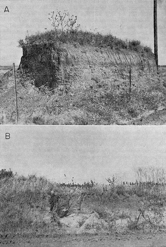
High terrace and volcanic ash deposits are the only known Lower Pleistocene deposits in Ottawa County. The volcanic ash is the Pearlette Ash of late Kansan age (Swineford and Frye, 1946). The high terrace deposits are classified as Nebraskan age. They are present only along Salt Creek, West Chapman Creek, and Coal Creek (Pl. 6A). No deposit exceeds 15 feet in thickness.
The high terrace deposits are composed of locally derived materials--mostly sand and iron nodules of the Dakota Formation, but the terrace deposit north of Ada is derived predominantly from Greenhorn Limestone. The sorting generally is very poor. No fossils were found in any terrace deposit. The Pearlette Ash is composed of slightly weathered volcanic ash, having a predominance of silt-size glass shards.
The high terrace and ash deposits lie above the water table and do not yield water to wells.
Plate 6--A, High terrace deposit of Nebraskan age south of Salt Creek composed of locally derived material. B, Typical loess deposit in the SE SE SW sec. 25, T. 10 S., R. 4 W.
Illinoisan Stage Terrace Deposits
Illinoisan terraces flank major stream valleys, and remnants flank some of the major tributaries. Depending on the size of the drainage area, Illinoisan terrace deposits may range in height from a few feet to 20 feet above the Wisconsinan terrace deposits. The thickest terrace deposit observed was 68 feet thick.
Sand and gravel are at the base of the Illinoisan terrace deposits. The sediments grade upward to silt and clay sizes. The test hole in the NW NW NE sec. 15, T. 9 S., R. 4 W., penetrated 44 feet of sand and gravel, of which 38 feet was water saturated. Ordinarily, only 5 to 15 feet of sand and gravel may be expected. The sand and gravel are derived from the Ogallala Formation, which in turn was derived from the Rocky Mountains, and are composed mainly of quartz but contain abundant feldspar and smaller amounts of magnetite, tourmaline, sphene, amphiboles, and pyroxenes.
Water supply--Where saturated, Illinoisan terrace deposits yield large quantities of water to wells. The water may be hard and may contain much bicarbonate and iron locally, but it is potable and may be used for irrigation. The towns of Delphos and Tescott and irrigation wells in sec. 3, T. 9 S., R. 4 W.; sec. 18, T. 9 S., R. 4 W.; and sec. 21, T. 11 S., R. 3 W., derive water from Illinoisan terrace deposits.
Wisconsinan Stage Terrace Deposits
Wisconsinan Stage terrace deposits, in this report, include all the terrace deposits that are younger than Illinoisan and older than material (alluvium) covered by the average annual flood. All deposits along intermittent tributaries are mapped as Wisconsinan terrace deposits because the alluvium is too insignificant to be mapped separately. The terrace deposit, including a thin strip of alluvium, is more than 2 miles wide in places along Solomon River but is not more than 70 feet thick. Along major tributaries the thickness of the terrace deposits near the confluence with Solomon River is equal to that of the Solomon, but along smaller tributaries the thickness at the confluence is less than in the Solomon Valley.
Wisconsinan terrace deposits are similar to Illinoisan terrace deposits in lithology and grading but differ in topographic position. Sand and gravel of the Wisconsinan terraces, like those of the Illinoisan, are composed chiefly of quartz, although feldspars are common, but unlike those in the Illinoisan terraces, they contain only small quantities of heavy minerals. Wisconsinan terraces are topographically lower than Illinoisan terraces except in a few places where natural levees of Wisconsinan age rise above the Illinoisan terraces.
Water supply--Moderate quantities of water having a wide range in quality are obtained from several wells in the Wisconsinan terrace deposits. Generally the quality is good, but in the southeast, where the terrace deposits come in contact with rocks of the Wellington Formation or Kiowa Shale, wells yield mineralized water. Also, in the broad floodplain area at the confluence of Solomon River and Salt Creek, the aquifer is very silty and its water contains a greater concentration of dissolved solids. No irrigation wells obtain water from the Wisconsinan terrace deposits.
Undifferentiated Deposits
Loess, colluvium, buried soils, sheet wash, and thin alluvial deposits overlie Upper Pleistocene terraces where they adjoin bedrock. They attain their greatest thickness along the north and east side of Solomon River and the north side of Salt Creek. These deposits do not exceed 70 feet in thickness. Although most of these deposits are Late Pleistocene in age, Pearlette Ash and 20 feet of material of Early Pleistocene age below it were present in one locality.
These undifferentiated deposits represent several types of sedimentation. At some places, the basal part contains a few feet of well-sorted sand, which may be saturated. Commonly the rest of the deposit is composed of silt-size particles, which may be in the form of loess, clayey ancient soils showing structure, or colluvium, or any combination of the three. A typical loess deposit is shown in Plate 6B.
Water supply--Several wells obtain small amounts of water from the coarse basal fractions of these deposits where they overlie relatively impermeable bedrock, such as the Wellington Formation and Kiowa Shale or clay of the Dakota Formation. The quality of water is likely to be very poor if the deposits are in contact with the Wellington Formation or Kiowa Shale.
Alluvium
In this report, alluvium includes that material that is covered by the river at the stage of its average flood. Rare major floods that cover the entire valley may deposit some sediment on Wisconsinan terraces, hence the terrace deposits may be concealed. Alluvium was mapped along perennial streams only. Its thickness ranges from about 20 to 40 feet.
The alluvium is composed of unconsolidated sand, gravel, silt, and clay and commonly contains organic residue.
No wells were observed in the alluvium as defined above, but moderately large yields may be expected.
Prev Page--Geology || Next Page--Ground water
Kansas Geological Survey, Geology
Placed on web March 23, 2009; originally published January, 1962.
Comments to webadmin@kgs.ku.edu
The URL for this page is http://www.kgs.ku.edu/General/Geology/Ottawa/05_form.html