![]()
Prev Page--Geography || Next Page--Formations
General Geology
[Note: The stratigraphic nomenclature used in this report is that of the State Geological Survey of Kansas and does not necessarily follow that of the U. S. Geological Survey.]
Geologic History
A study of the geologic history of north-central Kansas aids in understanding the geology of Ottawa County. The sequence of sedimentation and structural events in north-central Kansas is adapted, in part, from Lee (1956).
An uneven surface of Precambrian granite, gneiss, and schist underlies Paleozoic rocks in the county. During Late Cambrian and Early Ordovician time, a large syncline, in which the Arbuckle Group was deposited, extended northwestward across central Kansas. The Southeast Nebraska Arch, which extended into north-central and northeastern Kansas, formed the northern flank of the syncline. From Middle Ordovician until Mississippian time, the Southeast Nebraska Arch subsided, forming the North Kansas Basin, and the southwest flank of the syncline arched upward, accentuating the Central Kansas Uplift. St. Peter Sandstone, Platteville Formation, Viola Limestone, Maquoketa Shale (all of Ordovician age), Silurian dolomite, and Chattanooga Shale (Devonian and Mississippian) were deposited during this time. The Central Kansas Uplift attained its maximum development near the end of the Mississippian Period; uplift had ceased when the Wellington Formation (Permian) was deposited. Near the end of the Mississippian Period the Nemaha Anticline began to arch upward, splitting the North Kansas Basin into the Forest City Basin on the east and the Salina Basin on the west. Most of the uplift occurred during the Pennsylvanian Period, however.
Rocks of Mississippian and Pennsylvanian ages in Ottawa County include (older to younger): Upper Sedalia Dolomite, Gilmore City Limestone, Burlington Limestone, Keokuk Limestone, Warsaw Limestone, and Salem Limestone (Mississippian) and Cherokee, Marmaton, Pleasanton, Lansing, Kansas City, Douglas, Shawnee, and Wabaunsee Groups (Pennsylvanian). The abundance of Mississippian limestone indicates that an epicontinental sea prevailed during this time, whereas Pennsylvanian shale, limestone, and sandstone indicate deposition in various environments.
Permian deposits include the Wolfcampian Series (Admire, Council Grove, and Chase Groups), and the Leonardian Series (Sumner Group). Rocks of the Wolfcampian Series are principally shale, limestone, and sandstone. In general, each group is more saliferous than the older underlying group. Rocks of the Leonardian Series include thick beds of varicolored shale, redbeds, massive salt beds, gypsum beds, and thin beds of limestone. The withdrawal of Permian seas, aided by a gentle tilting of the area toward the Hugoton Embayment, was followed by a long period of erosion. Triassic and Jurassic strata are absent in north-central Kansas, although the Morrison Formation (Jurassic) is in the subsurface of western Kansas.
In most places, a cobble zone lies on the eroded surface of Permian rocks at the contact of Permian and Cretaceous rocks. This cobble zone underlies Cheyenne Sandstone, Kiowa Shale, or Dakota Formation, depending on which formation is in contact with Permian rocks (Plummer and Romary, 1942). Perhaps these cobbles are the only remnant of Triassic and Jurassic erosion. The Permian surface has relief as much as 100 feet (Green, 1909).
The advance of a Cretaceous sea began a phase of earth history that strongly affected the physiography and mineral resources of Ottawa County, for most of the rocks that crop out in the county are of Cretaceous age. The depositional environments of these Cretaceous rocks have been the object of speculation for many years. Twenhofel (1920) stated that the sea encroached from the south. Cheyenne Sandstone was a continental deposit along the margin of the sea southwest of Ottawa County and was overlain by marine Kiowa Shale as far north as Salina. During deposition of Dakota sediments, the sea advanced and retreated several times between south-central Kansas and the area near Salina, including at least one advance to southern South Dakota. Twenhofel believed the Dakota Formation to be part marine and part continental and that the Cretaceous sea retreated as far south as Texas; then it advanced and deposited the post-Dakota chalky limestones and shales of the Colorado Group. After additional study, Twenhofel (1924) suggested the possibility of a disconformity between the Kiowa and Dakota because of channel fillings that cut through the "Mentor" beds of Kiowa age, but be preferred the concept that the Kiowa and Dakota intertongue and are contemporaneous--the Dakota being the terrestrial equivalent of the Kiowa. Stanton (1922) agreed with Twenhofel that the Cheyenne and Kiowa were deposited in one transgression but thought that the Dakota represented a halt in advance of the sea rather than a retreat of the sea to Texas. He pointed out that the Kiowa and Dakota or the Dakota and the overlying Graneros Shale are not separated by distinct boundaries.
Depositional environment of the Dakota received additional explanation by Rubey and Bass (1925, P. 62) who stated,
. . . variegated and carbonaceous mudstones . . . might be interpreted as silts and fine sands deposited in the back waters of wide flood plains, the various colors possibly being due to different degrees of oxidation. . . . The evenly bedded sandstone unit at the top of the Dakota may have been deposited as beach sands, the immediately ensuing marine Graneros Shale and the general aggradation of the stream valley suggesting an encroachment of the sea.
Plummer and Romary (1942) compared the environment of Dakota time with the Mississippi delta of the present. They stated also that the sandstones have no stratigraphic significance and may be at any position in the section. Most of these theories on depositional environments during Cretaceous time seem to be satisfactory, but a more comprehensive explanation is warranted.
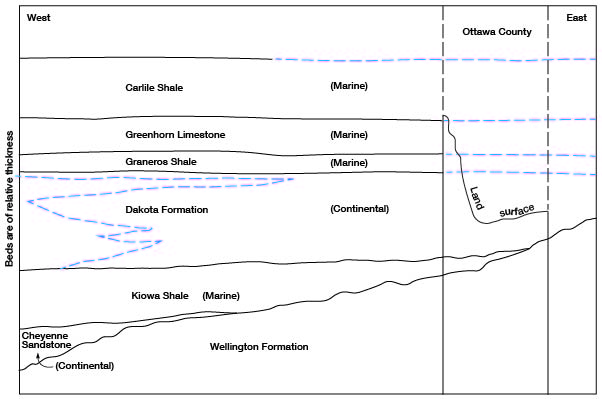
The Cretaceous sea advanced slowly from the south, sorting and reworking the continentally derived Cheyenne Sandstone on an uneven surface eroded in rocks of Permian age. The marine Kiowa Shale, which overlies the Cheyenne Sandstone conformably but extends farther northward and eastward, was deposited farther off shore during the advance of the sea (Fig. 3). The Cheyenne Sandstone is not present in Ottawa County, but it is in Russell County about 40 miles farther west, (Rubey and Bass, 1925), where it thins from 62 feet in the western part to 0 feet in the eastern part.
Figure 3--Diagrammatic cross section showing Cretaceous sedimentation in north-central Kansas through central Ottawa County. Not to scale.
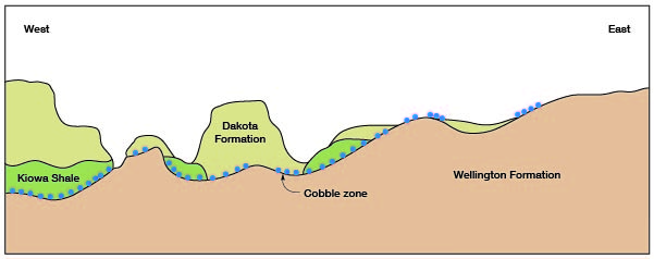
The Kiowa Shale overlies strata of Permian age unconformably and was deposited in a shallow sea at least as far east as Ottawa County but probably not much farther north on the eastern boundary of the basin. Portions of the Kiowa directly overlying Permian strata are composed of siltstone, but higher in the section the siltstone grades into fissile shale. Near the end of Kiowa time, subsidence ceased and erosion of Kiowa Shale began along its eastern border of deposition leaving several erosional remnants in Ottawa County (Fig. 4). Deposition of sand, silt, and clay of the Dakota Formation began after the erosional surface on the Kiowa was formed. Erosional channels in the Kiowa were filled with sandstone of Dakota age; a channel in sec. 14, T. 10 S., R. 1 W., is 20 to 25 feet deep. Erosion since Dakota time reveals irregular Permian-Kiowa-Dakota interrelations (Fig. 5).
Figure 4--Generalized section across southeastern Ottawa County showing the post-Kiowa pre-Dakota erosional surface.
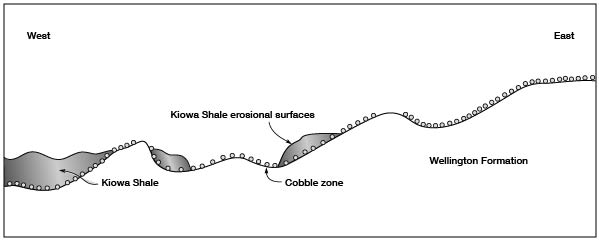
Figure 5--Generalized section across southeastern Ottawa County showing typical stratigraphic relations.
An environment under which each of the Dakota lithologies was deposited must be considered. Well-sorted, cross-bedded channel and bar-finger sandstones cut through other sediments throughout the Dakota section, and well-sorted, massive sandstones, indicating delta-front sheet or delta-margin island sands (Fisk, 1955) also are abundant. Thin-bedded to massive siltstones indicate long periods of constant settling velocity typical of estuaries or deltas. Thin to massive beds of claystone and clay are indicative of a very low settling velocity and may have been deposited in lagoons, lakes, swamps, stagnant streams, or deltas. The clay has been colored variously by chemical action since the time of deposition. Lignite and other carbonaceous matter is disseminated throughout many beds of clay. Pyrite is common in much of the section, and imperfect selenite crystals are common locally. The Dakota Formation contains numerous local unconformities.
Both continental and marine fossils have been found in the Dakota. An Ankylosaurus, resembling a heavily armored giant armadillo, estimated to have been 8 to 10 feet long, was collected in 1955 by members of the staff of the Museum of Natural History, University of Kansas. This dinosaur was found in the SW sec. 8, T. 10 S., R. 1 W., which would place it stratigraphically about 100 feet above the base of the Dakota. Leaves of Sassafras, Laurus, Magnolias, Platanus, Populus, Salix, and Menispermites have been found at various horizons in nearby counties (Lesquereux, 1874). Marine invertebrates were reported by Stanton (1922) near the top of the formation in adjoining counties to the west.
The Dakota Formation probably was deposited in a marshy coastal area of low relief. Meandering streams built overlapping flood plains and deltas. Dicotyledonous leaves indicate a temperate and subhumid to humid climate. The degree of sorting in the channel sands and silts indicates perennial streamflow. Dip of cross beds, although locally variable, indicates that streamflow generally was from the northeast. The Cretaceous sea basin was filled slowly and crustal movement was slight. This accounts for the similarity of Dakota sediments over a wide area and yet allows for a distinct faunal change between Kiowa and Graneros times.
The Dakota environment may have been comparable to that of the Texas Gulf Coast today. The Gulf Coast includes a wide area of low land extending toward and filling the Gulf of Mexico. Parts of the coast between New Jersey and Georgia also illustrate similar characteristics, such as sand bars, lagoons, estuaries, wide flood plains, extensive swamps (Dismal Swamp), and a variety of vegetation. Lesquereux (1874) described the Dakota of central Kansas and compared its deposition with deposition along the shore of the North Sea in Holland and Belgium.
In western Kansas, some of the Dakota exhibits a marine aspect; glauconite is common in well cuttings. Figure 3 illustrates the marine characteristics of the Dakota basinward.
The Dakota in Ottawa County has a distinct lithologic pattern. The lower section contains large quantities of sand intermixed with silt and clay. The middle section is composed chiefly of silt and clay containing scattered lenticular beds of sandstone. The upper section has large amounts of sand intermixed with silt and clay and is similar to the lower section. Sandstone in the upper and lower parts of the Dakota is expressed as rugged topography, and the middle Dakota is expressed as gently rolling hills. All beds are lenticular and traceable for only a few miles. The uppermost sediments of the Dakota in Ottawa County show more distinct bedding than those in the middle. Although Janssen Clay and Terra Cotta Clay members might be mappable elsewhere, subdivision of the Dakota Formation was not practicable for this study.
Transgression of the sea began, ending Dakota time. Transgression continued slowly while the Graneros Shale, a noncalcareous fissile black shale, was being deposited conformably on the Dakota until conditions became favorable for the deposition of chalky Greenhorn Limestone and Carlile Shale (Fig. 3). Perhaps the climate changed in addition to subsidence.
Post-Dakota deformation tilted the rocks northward and could have induced the Cretaceous sea to recede in this direction. Stratigraphic evidence of the sea's recession from Ottawa County has been removed by extensive erosion since the Cretaceous Period. Presumably, in north-central Kansas the Tertiary Period was a time of extensive erosion. The Ogallala Formation, of Pliocene age, composed of material derived from the Rocky Mountains, was spread over the western half of Kansas, but the only remnant of Tertiary deposits in Ottawa County is a 3- to 4-inch bed of "Algal" limestone, which is regarded as the uppermost bed of the Ogallala Formation.
Events of early Pleistocene time (Nebraskan and Kansan Stages) are indicated only vaguely. High, locally derived terrace deposits are perched 100 feet above the present floodplain and relatively near the confluence of some minor tributaries with the major drainage. These terrace deposits, lying far below the Ogallala, probably are of the Nebraskan Stage. One high terrace deposit in sec. 8, T. 10 S., R. 5 W., lies adjacent to a tributary stream 3 1/2 miles north of Salt Creek, an eastward-flowing stream that is entrenching itself southward. A bed of Pearlette Ash of Kansan age, identified by Swineford and Frye (1946), crops out only 1 mile north of Salt Creek, in sec. 29, T. 10 S., R. 5 W., near the tributary adjacent to the high terrace deposit. The terrace deposit is at an altitude of about 1,380 feet and about 40 feet above the tributary, but the ash is at 1,290 feet and about 5 feet above the tributary, which is about 10 feet above Salt Creek; hence, the terrace deposit is much older than the ash and probably is of Nebraskan age. Fossils were not found.
If the above hypothesis is correct, only those few terrace deposits remain that were protected from stream action subsequent to their deposition. The valleys were widened and deepened extensively during the Kansan Stage, but subsequent erosion has removed Kansan terrace deposits. The only identifiable Kansan bed remaining is the Pearlette Ash. This theory is in accord with conclusions of regional Pleistocene studies in Kansas (Frye and Leonard, 1952) except that the writer believes that drainage flowed eastward through the Flint Hills throughout Pleistocene time. Frye and Leonard (1952) stated that Solomon and Saline Rivers flowed southward into the McPherson Valley until captured by the ancestral Kansas River during late Kansan or early Yarmouthian time.
Pearlette Ash was found in three localities in Ottawa County. The deposit in sec. 29, T. 10 S., R. 5 W., is approximately 6 feet thick and is lenticular. A small pocket of ash occurs in the hills of northeast Ottawa County in sec. 3, T. 9 S., R. 2 W., at an altitude of about 1,390 feet. A 1-foot auger sample collected in sec. 2, T. 10 S., R. 4 W., outside of the river terraces in Solomon River valley was identified as Pearlette Ash by Swineford (personal communication). The measured altitude of this lenticular bed is 1,276 feet, which is 32 feet below land surface.
After the Pearlette Ash was deposited as a thin layer over the land surface during the Kansan Stage, it could not have remained in place long. The ash probably collected in depressions or protected places and remains as an indicator of Kansan Stage topography. Later redeposition is unlikely, as the ash is not contaminated with other materials. On these assumptions, the three Pearlette Ash deposits indicate that post-Kansan erosion has not removed much material from the uplands but has deepened the major drainage.
Erosion during the Illinoisan and Wisconsinan Stages extended and enlarged the effects of erosion started in earlier Pleistocene time. Most of the earlier terrace deposits were removed and new ones created during the Illinoisan Stage. Illinoisan terraces flank the major streams, and scattered deposits remain along the major tributaries. In many places the Illinoisan terrace deposits are as thick as the Wisconsinan terrace deposits.
Erosion early in the Wisconsinan Stage did not appreciably widen the valleys as it did during the Illinoisan Stage, but it did cut a large channel through the Illinoisan terrace deposits and in most places deepened the valleys slightly. A major factor in deepening and widening the valleys is increased water velocity, which may be caused by increased gradients or by increased stream discharge. Under the fluctuating climatic conditions of the Pleistocene Epoch, increased quantity of flow is a more logical explanation than crustal movement or headward advance of a knickpoint. Alluviation late in the Wisconsinan Stage filled the channels thus cut. The normal sequence of sediments consists of gravel at the base grading upward to silt and clay. As the particle size of suspended sediment is dependent on water velocity, it is apparent that the average velocity of streamflow has decreased considerably during and since late Wisconsinan time; aggradation continues to the present day.
A mantle of eolian silt and colluvium, which probably has been accumulating since Illinoisan time, overlies the terrace borders and adjoining bedrock. The deposits are confined mainly to the east side of Solomon River and the north side of Salt Creek.
In summary, the geologic history of Ottawa County has been varied but not complex. Paleozoic sediments were deposited in epicontinental seas or near their borders. During the Mesozoic, a long period of erosion preceded transgression of the Cretaceous sea. Dakota time marked a halt in advance of the sea while continental sediments filled the Cretaceous sea toward the center of the basin. Renewed transgression provided the depositional environment of post-Dakota rocks of the Colorado Group. Erosion was extensive during Tertiary time except for minor deposition of the Ogallala. The land surface today is a product of repeated attacks by Pleistocene water power, the impact of which has been partly disguised by alluviation.
Summary of Stratigraphy
The oldest rocks that crop out in Ottawa County are in the Wellington Formation, of the Permian System, exposed only in the southeastern part of the county. The Kiowa Shale, of the Cretaceous System, overlies the Wellington unconformably. The Kiowa pinches out on the surface in the east but attains a subsurface thickness exceeding 80 feet in the west. The Dakota Formation (Cretaceous) unconformably overlies the Wellington Formation and Kiowa Shale in the eastern part of the county, where the upper part of the Dakota is eroded, and thickens to about 350 feet in the western part, where the entire thickness remains. The Graneros Shale (Cretaceous) conformably overlies the Dakota and is about 38 feet thick. The Greenhorn Limestone (Cretaceous), about 75 feet thick, is conformable below with the Graneros Shale and above with the Carlile Shale (Cretaceous), which has been so eroded that the thickness in Ottawa County is not more than 15 feet.
Nebraskan terrace deposits, of Early Pleistocene age, are not more than 15 feet thick, but Illinoisan and Wisconsinan terrace deposits, of Late Pleistocene age, which fill the valleys, may be as thick as 70 feet. Loess and colluvial deposits have a considerable range in thickness; the maximum observed was 70 feet.
A tabular summary of the stratigraphy is given in Table 2. The surface relations of the rocks are shown on the geologic map (Pl. 1).
Table 2--Geologic formations of Ottawa County and their water-bearing properties. Stratigraphic nomenclature of the State Geological Survey of Kansas.
| System | Series | Stratigraphic unit |
Thickness, feet |
Character | Water-bearing properties |
|---|---|---|---|---|---|
| Neogene | Pleistocene | Alluvium | 0-40 | Unconsolidated sand, silt, and clay deposited in river channels of major valleys. | Where saturated, yields moderate quantities of good water to wells. |
| Upper Pleistocene rocks, undifferentiated |
0-70 | Unconsolidated sand, silt, and clay; loess, colluvium, and buried soils. | Where saturated, yield small quantities of hard water to wells. | ||
| Wisconsinan (Stage) terrace deposits |
0-70 | Unconsolidated sand, gravel, silt, and clay; graded, feldspathic. | Where saturated, yield moderate to large quantities of good to hard water to wells. | ||
| Illinoisan (Stage) terrace deposits |
0-70 | Unconsolidated sand, gravel, silt, and clay; graded, feldspathic. | Where saturated, yield moderate to large quantities of good to hard water to wells. Locally, water has high iron content. | ||
| Nebraskan and Kansan (Stage) terrace deposits |
0-15 | Locally derived sand and gravel, silt, clay, and volcanic ash. | Not known to yield water to wells in Ottawa County. | ||
| Cretaceous | Upper Cretaceous |
Carlile Shale |
0-15 | Gray calcareous shale, thin chalky limestone, thin bentonite beds. | Not known to yield water to wells in Ottawa County. |
| Greenhorn Limestone |
0-75 | Chalky light-gray limestone; crystalline limestone, thin bentonite beds near base, fossiliferous. | Not known to yield water to wells in Ottawa County. | ||
| Graneros Shale |
0-38 | Dark-gray, noncalcareous shale; thin bentonite beds, fossiliferous. | Not known to yield water to wells in Ottawa County. | ||
| Lower(?) Cretaceous |
Dakota Formation |
0-350 | Lenticular fine to medium sand, consolidated and unconsolidated, iron oxide and carbonate cement, light-brown to yellow silt; red, yellow, gray, brown, red-gray mottled clay, lignite, pyrite, gypsum. | Where saturated, yields small to moderate quantities of good to hard water to wells. Locally, water has high iron content. | |
| Lower Cretaceous |
Kiowa Shale |
0-80 | Gray siltstone, gray fissile shale; cone-in-cone, fine sandstone lenses, gypsum, pyrite. | Not known to yield water to wells in Ottawa County. | |
| Permian | Middle Permian |
Wellington Formation |
50+ | Bright red and green shale, thin fine-grained crystalline limestone. | Not known to yield water to wells in Ottawa County. |
Structure
Regionally, Ottawa County lies near the axis of the Salina Basin, and rocks of Mississippian age and older are depressed to form the basin. Rocks of Pennsylvanian age and younger dip more gently and tend to fill the Salina Basin. Three deep test holes in the northwestern part of Ottawa County indicate that the top of the Dakota dips S 80° W about 20 feet per mile.
Some local structures are present within the county. Vine Creek Dome (Folger, 1948) lies approximately 6 miles west of Lindsborg Anticline and has its apex in sec. 27, T. 10 S., R. 1 W. The dome extends generally north-south for 8 miles and has about 40 feet of closure. Wildcat wells on and near Vine Creek Dome have proved unproductive.
A high-angle normal fault extends approximately 5 miles from sec. 10, T. 12 S., R. 3 W., to sec. 19, T. 12 S., R. 2 W. The north side of the fault has dropped about 20 feet. Although the fault may be observed only in a few places, local geology indicates that the fault may extend several miles farther northwest, parallel to Solomon River. Thus, the course of the river may have been affected by the fault.
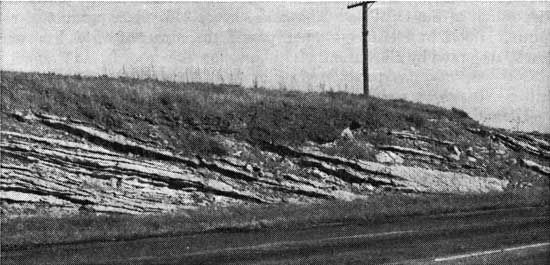
Minor flexures are common throughout the county, but their distribution has no pattern. They, and minor faults, seem to be caused by local adjustment. Depositional features (Pl. 2) may seem to be the result of structural movement but close examination shows them to be fore-set beds.
Plate 2--Fore-set beds in Dakota Formation.
Geomorphology
The course of Solomon River and its tributaries is a direct result of the regional and local structure and the lithology of the stratigraphic units. Although much of the drainage history of Solomon River is not known, some geologic factors in the county have affected its course. Where the Solomon enters the northwestern part of the county, its course changes from southeastward to southward. Test holes across the valley near Delphos indicate that a buried Illinoisan channel lies about a mile east of the present channel. General topographic expression indicates a down-dip (westward) entrenchment. From the Salt Creek-Solomon River confluence to the southeastern part of the county, the Solomon borders the southern valley wall along the downthrown side of the fault in T. 12 S., R. 2 and 3 W. A southern extension of Vine Creek Dome (or Lindsborg Arch) causes the river to veer southward where it leaves the county. Salt Creek, though relatively small in drainage area, is a mature stream with paired, inverted terrace development, but it lacks Kansan terraces. Pearlette Ash is present, however. High terraces (Nebraskan or Kansan) border the Solomon Valley west of Glasco but not in Ottawa County.
Tributaries of Solomon River in the county are controlled by variations in Dakota lithology. Indurated clay or case-hardened zones in sandstone cemented with iron oxide generally form local drainage divides. Consequently, the tributaries tend to follow unconsolidated channel or bar sandstones or silt lenses. Present stream drainage aids in understanding the Dakota environment.
Prev Page--Geography || Next Page--Formations
Kansas Geological Survey, Geology
Placed on web March 23, 2009; originally published January, 1962.
Comments to webadmin@kgs.ku.edu
The URL for this page is http://www.kgs.ku.edu/General/Geology/Ottawa/04_geol.html