![]()
Prev Page--Geology || Next Page--Ground water
Geomorphology
The events that created the present topographic features started at the close of Pliocene deposition and the beginning of Pleistocene erosion. During early Pleistocene time streams began cutting into the consolidated Cretaceous materials. No deposits of Nebraskan age have been recognized in Lincoln County; events that took place here during that time are therefore deduced only from deposits of known Nebraskan age in other areas. By Kansan time the major streams followed very nearly the same pattern as do the present streams, except for Saline River which flowed through Wilson Valley into Smoky Hill River. Deposits of Kansan age fill the Wilson Valley channel in the southwest corner of the county.
A period of erosion and downcutting followed the deposition of the Kansan channel deposits of the Meade formation. During this erosional period, a stream flowing in the lower Saline Valley cut down and captured the stream in upper Wilson Valley, causing it to flow in approximately the present Saline River Valley. This downcutting produced channels 30 to 50 feet below the bedrock surface. As the downcutting diminished during late Illinoian time, the streams were again depositing over the valley floors of this area. These deposits may have been a source of some of the material of Loveland age that occurs on the small upland areas adjacent to the valley. During the following period (Sangamonian time) there seems to have been a comparatively small amount of erosion and deposition. Thus ideal conditions for the development of Sangamon soil were present.
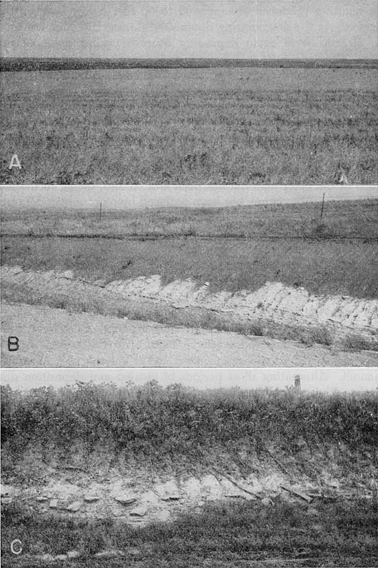
Another erosional cycle which cut channels into the older material occurred during early Wisconsinan time. In many places much of the older material has been eroded and, owing to the late Wisconsinan alluviation, has been replaced by more recent deposits. During early Wisconsinan time, while the valley floors were being covered by alluvial material, a loess mantle (Pl. 7) was deposited over much of the upland area of northwestern and north-central Kansas. This loess material has been correlated with the Peoria silt member of the Sanborn formation. The Peorian loess probably originated from the Platte and Republican River Valleys. (Swineford and Frye, 1951).
Plate 7--A, Loess-mantled upland divide area in sec. 24, T. 10 S., R. 10 W. Loess is about 8 feet thick and overlies Cretaceous Greenhorn limestone. B, Loess and colluvium on Greenhorn limestone exposed in road cut in graded pediment surface south of Sylvan Grove. C, Thin loess mantle over Carlile shale capping upland divide area; exposed in a road cut in the SW sec. 18, T. 10 S., R. 7 W. (Photos by John C. Frye.)
At the close of Wisconsinan time another period of erosion formed the gullies, canyons, and erosional features of the present upland area. Saline River was rejuvenated and it cut the present stream channel. Alternating short periods of erosion and deposition during late Pleistocene time have covered the older deposits immediately adjacent to Saline River with an alluvial veneer.
Prev Page--Geology || Next Page--Ground water
Kansas Geological Survey, Geology
Placed on web March 5, 2009; originally published July, 1952.
Comments to webadmin@kgs.ku.edu
The URL for this page is http://www.kgs.ku.edu/General/Geology/Lincoln/05_geom.html