![]()
Prev Page--Geography || Next Page--Geomorphology
Geology in Relation to Ground Water
Summary of Stratigraphy
[Note: The geologic classification and nomenclature of this report follow the usage of the State Geological Survey of Kansas and do not conform in all respects to the usage of the U. S. Geological Survey.]
The rocks that crop out or are present immediately beneath the surface in Lincoln County are sedimentary in origin. They range in age from early Cretaceous (Comanchean Series) to Quaternary (Moore and others, 1951). The areal distribution of the surficial deposits is shown on Plate 1. Although the Cheyenne sandstone and Kiowa shale of early Cretaceous age do not occur at the surface, they are referred to in this report because of their water-supply potentialities. The Cheyenne sandstone pinches out toward the east and is absent beneath much of the eastern part of the county. The Kiowa shale lies immediately below the Dakota formation which crops out in large areas adjacent to Saline River and its tributaries. The Graneros shale overlies the Dakota formation and caps the lower bills adjacent to the valley. The Graneros shale forms a gentle grade from the top of the Dakota formation to the overlying Greenhorn limestone. The resistant limestone beds of the Greenhorn form the prominent escarpments along the tributaries of Saline River and extend over large upland areas in the northern and southwestern part of the county. The Carlile shale caps the uppermost hills in the northern and southwestern parts of the county; however, it crops out only where the loess has not been deposited or where the loess has been eroded.
The Ogallala formation of Pliocene age is represented by small deposits of "Algal limestone," which cap some of the uppermost hills in the central-southwest and central parts of the county.
Deposits of the Meade formation of Pliocene age fill an abandoned stream channel (Wilson Valley) in the southwest corner of the county. Other Pleistocene deposits in the county are the loesses of the Sanborn formation, which extend over much of the uplands, and the terrace deposits adjacent to Saline River and its tributaries. Alluvium of late Pleistocene age is deposited in the present stream channels and is also found as a thin veneer over much of the bottom land.
The character and ground-water supply of the geologic formations in Lincoln County are described briefly in the generalized section (Table 2).
Table 2--Generalized section of the geologic forinations of Lincoln County.
| System | Series | Subdivisions | Thickness, feet |
Character | Water supply |
|---|---|---|---|---|---|
| Quaternary | Pleistocene | Recent alluvium Unconformable on older formations |
0-60 | Sand, gravel, clay, and silt; buff to tan. Predominantly fine sand and silt. | Yields supplies of water for domestic and stock use. Quantities are limited. |
| Sanborn formation Unconformable on older formations Meade formation |
0-35 | Loess, sand, and locally, colluvium at the base; tan to gray-buff. Sand and gravel locally cemented. | Yields little or no water to wells in this area. | ||
| 0-40 | Gravel, sand, silt, clay, volcanic ash, and caliche; gray, tan, and buff. | Yields meager supplies of water to wells. | |||
| Tertiary | Pliocene | Ogallala formation Unconformable on older formations |
0-4 | "Algal limestone," pink, gray, and tan. Fresh-water limestone and caliche. | Yields no water to wells. |
| Cretaceous | Gulfian | Carlile shale | 0-20 | Shale, chalky to black, fissile. Contains some limestone interbedded. | Yields no water to wells. |
| Greenhorn limestone | 65-90 | Shale and limestone interbedded. Shale is calcareous, tan to blue-gray; limestone is thin-bedded, fossiliferous, gray. | Weathered limestone yields some potable water to shallow wells. | ||
| Graneros shale | 20-35 | Shale, blue-gray, locally contains clay, siltstone, and sandstone. Contains selenite and pyrite. | Yields little or no water to wells. | ||
| Dakota formation | 140-200± | Clay, shale, siltstone, and sandstone interbedded and varicolored. Contains abundant siderite, hematite, limonite, and some lignite. | The sandstone yields moderate quantities of water of variable quality. Generally, shallow wells yield good water and deep wells yield poor water. | ||
| Comanchean | Kiowa shale | 75-100± | Yields little or no water to wells. | Shale, black, containing thin beds of sandstone and siltstone, and crystals of gypsum and pyrite. | |
| Cheyenne sandstone |
0-100± | Sandstone, medium to fine-grained, gray; some shale and siltstone. | Yields no water to wells. |
Cretaceous System
Comanchean Series
Cheyenne Sandstone
Character--The Cheyenne sandstone was named by Cragin (1889, p. 65) from Cheyenne Rock--an indurated mass of sandstone that forms a prominent ledge on the north side of the Medicine Lodge Valley about three-fourths of a mile west of Belvidere, Kiowa County, Kansas.
The Cheyenne sandstone does not crop out in Lincoln County; hence, little is known of its lithologic character in this area except as determined by the cuttings from a domestic well drilled in the extreme western part of the county (Table 14). The formation has been described in detail by Latta (1946) at the type locality near Belvidere. Latta (1946, p. 235) states:
The Cheyenne consists chiefly of light-colored fine- to medium-grained friable cross-bedded sandstone and lenses of sandy shale and conglomerate. Minor amounts of clay, selenite crystals, iron nodules, and pyrite occur in different parts of the formation. The bedding is extremely irregular and discontinuous so that it is impossible to trace any one bed for more than a short distance. Most of the beds are merely lenses of limited extent.
The material penetrated in the drilling of the domestic well described above consisted of fine- to medium-grained sandstone and ranged from white to gray in color.
Distribution and thickness--The Cheyenne sandstone probably underlies only parts of extreme western Lincoln County. A test hole drilled to the Permian red beds in the central part of the county did not penetrate any Cheyenne sandstone. Although large areas in the southwestern part of Kansas are underlain by the Cheyenne, it crops out in only a very few localities. The principal outcrops are in the Belvidere area of southwestern Kiowa County.
The thickness of the Cheyenne sandstone in Lincoln County has not been determined; however, it has been reported by Latta (1946) to range from 32.5 to 94 feet in the Belvidere area and to average about 45 feet.
Water supply--Only one well is believed to derive water from the Cheyenne sandstone. The material penetrated in this well was permeable enough to supply water for domestic and stock use. However the uncertainty as to the occurrence of the formation beneath the surface in Lincoln County makes it inadvisable to depend on it for a water supply.
Kiowa Shale
Character--The Kiowa shale was named by Cragin (1894, p. 49) from exposures in Kiowa County, Kansas. As used in this report, the term Kiowa shale includes the thick series of marine shale, sandstone lenses, and fossiliferous limestones between the Cheyenne sandstone or Permian rocks and the Dakota formation. In the western part of the county, the Kiowa shale conformably overlies the Cheyenne sandstone and in the remainder of the county unconformably overlies Permian rocks. The Kiowa shale, overlain conformably by the Dakota formation, does not crop out in Lincoln County. Data presented here are compiled from well logs.
The Kiowa shale consists of thinly laminated dark-gray to black shale in the lower part, grading upward into gray, tan, and brown clay and clay shale (Latta, 1946, p. 244). The shale in the lower part is generally black and has been called a "paper" shale because it is very thinly laminated. Thin beds of shell limestone--so called because they consist almost wholly of fossil shells--are a conspicuous feature of the formation, especially of the lower part. These beds are from 3 to 18 inches thick, generally light gray in color, and locally contain gypsum or pyrite. The matrix consists of shell fragments and sand or sand and clay. In some places, where oxidation of the pyrite has caused the rock to disintegrate, and the fossils are largely decomposed, the shell bed is stained with iron which gives it a red-brown or rusty color. Lenses of sandstone ranging in thickness from 1 to 18 inches and in color from light to dark gray, occur throughout the formation. Generally they are fine-grained and in many places are cemented.
Distribution and thickness--The Kiowa shale is not exposed in Lincoln County but crops out in Ellsworth County, which adjoins Lincoln County on the south. One measured section near Kanopolis has a thickness of 57 feet (Plummer and Romary, 1942, pp. 324-325). In the subsurface of Russell County, which adjoins Lincoln County on the west, the Kiowa shale attains a thickness of 105 feet in sec. 33, T. 13 S., R. 15 W. (Swineford and Williams, 1945, p. 164.)
At a test hole drilled in the NE sec. 21, T. 12 S., R. 6 W., in Lincoln County the Kiowa shale was approximately 80 feet thick. Indications are that the Kiowa shale underlies the county.
Water supply--Some wells in the county may derive water from the Kiowa shale. Wells penetrating a lens of sandstone in the Kiowa shale may produce quantities of water adequate for domestic or stock supplies. Because adequate water supplies can be obtained at shallower depths, most of the wells do not penetrate the Kiowa shale.
Gulfian Series
Dakota Formation
Character--The Dakota formation of Kansas has been referred to as or included in the "Dakota Group" (Meek and Hayden, 1862); "Dakota Sandstone" (Prosser, 1897); "Dakota formation" (Twenhofel, 1924); "Rocktown channel sandstone member" (Rubey and Bass, 1925); "Cockrum Sandstone" (Latta, 1941); and "Omadi formation" (Condra and Reed, 1943). The term "Dakota Group" (Meek and Hayden, 1862) was first applied to the sandstones, various colored clays, and lignite beds that underlie the "Benton Group" in exposures near Dakota City, Dakota County, Nebraska.
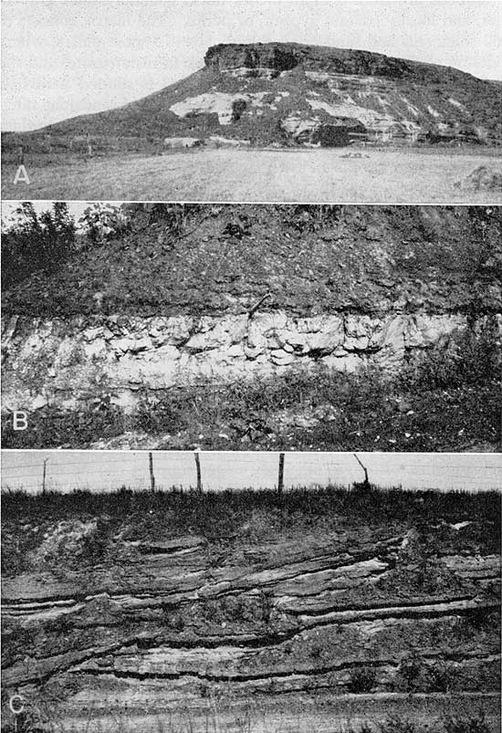
In this report, the Dakota formation includes the strata between the Kiowa shale (below) and the Graneros shale (above). The Dakota consists largely of gray to dark-gray shale, sandy shale, and varicolored clays containing lenticular beds of siltstone and sandstone. Owing to the resistant sandstone beds or lenses (Pl. 4A), it is generally believed that most of the Dakota formation is sandstone; however, investigations show that much of the formation is composed of clay and shale. Plummer and Romary (1942) describe the Dakota formation as consisting largely of clay of various colors, containing irregular lenticular beds of siltstone and sandstone. In their opinion the Dakota was deposited in a dominantly continental and near-shore environment, whereas the underlying and overlying formations were deposited under marine conditions.
Plate 4--A, Terra Cotta and Janssen Clay members of the Dakota formation in valley wall of Hell Creek, SE sec. 19, T. 13 S., R. 10 W. B, Uppermost part of the Dakota formation and lowermost part of the Graneros shale, NW ,sec. 13, T. 13 S., R. 9 W. Pick handle marks the contact. C, Fine-grained sandstone in the upper part of the Terra Cotta clay member of the Dakota formation, NW sec. 13, T. 12 S., R. 9 W. (Photos by John C. Frye.)
Surficial exposures and drill cuttings from the Dakota formation of this area contain concretions of limonite, siderite, and hematite. The Dakota also contains lignite, carbonaceous material, and calcium-cemented sandstone, or "quartzite."
The Dakota formation in Kansas consists of two members, the upper called Janssen clay member and the lower called Terra Cotta clay member.
Distribution and thickness--The Dakota formation in Lincoln County crops out over widespread areas adjacent to Saline River and its tributaries and underlies the rest of the county. Some of the best exposures are in the southern and southeastern parts of the county (Pl. 4B, 4C). Throughout much of the northern and southwestern parts of the county, the Dakota formation is overlain by Graneros shale and Greenhorn limestone, which in turn are overlain by Carlile shale or loess, or both.
The Dakota formation ranges in thickness from about 140 feet on the eastern side of the county to 200 feet at the western side. At a test hole drilled in the NE cor. sec. 21, T. 12 S., R. 6 W., the Dakota formation, because of the absence of the upper member, was only 135 feet thick.
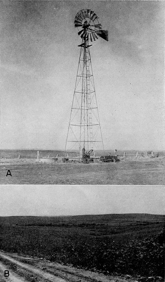
Water supply--Many wells in Lincoln County obtain their water supply from the Dakota formation. A typical well deriving water from the Dakota is shown in Plate 5A. Although much of the water from the Dakota formation is mineralized, the quantity generally is adequate for domestic and stock supplies. The water in most of the wells is under artesian pressure but flows at the surface from only a few of them. Data for determining the areas where water of good quality can be obtained are not available. Indications are that the water in the upper part of the Terra Cotta clay member of the Dakota has a high chloride concentration. Shallow wells in areas where the Janssen clay member of the Dakota formation is absent yield water with as much as 1,400 parts per million of chloride, whereas wells penetrating 100 feet of the Terra Cotta clay member yield water containing as little as 22 parts per million of chloride.
Plate 5--A, Typical well on the uplands drilled to a sandstone in the Dakota formation (total depth of well, 303 feet); on the Borman farm, SW SE sec. 22, T. 13 S., R. 9 W. B, Greenhorn limestone topography (background) and features of the Dakota formation (foreground); view (looking southwest) from sec. 9, T. 11 S., R. 6 W.
Graneros Shale
Character--The Graneros shale was named by Gilbert (1896) for Graneros Creek, Pueblo County, Colorado. The Graneros shale consists of blue-black fissile noncalcareous clay shale that is locally interbedded with sandy limestone, sandstone, and sandy shale. In Lincoln County the base is marked generally by a thin ironstone bed (Pl. 4B). A bentonite bed about 15 inches thick occurs near the top. Selenite crystals may be present throughout the formation.
The Graneros shale lies between the Dakota formation (below) and the Greenhorn limestone (above). The shale forms a gentle slope from the base of the Greenhorn limestone to the top of the Dakota formation (Pl. 5B).
Distribution and thickness--The Graneros shale ranging in thickness from 20 to 35 feet, underlies the northern and southwestern parts of the county. Most of the outcrops are in areas that have been exposed to stream erosion. These areas lie adjacent to Saline River and its major tributaries. The areal distribution of the Graneros shale is shown on Plate 1.
Water supply--No wells in Lincoln County are known to obtain water from the Graneros shale, which is impermeable. A water supply might be obtained if a sandstone lens in the shale were penetrated below the water table. As an adequate supply of water generally is obtained from either the Dakota formation or alluvial fills, no need has developed for wells in the Graneros shale.
Greenhorn Limestone
Character--Gilbert (1896, p. 564) named the Greenhorn limestone from exposures of interbedded limestone and shale near Greenhorn Station and along Greenhorn Creek about 15 miles south of Pueblo, Colorado. Tentative correlation of the Colorado section with central Kansas rocks referred to as "Benton" was made by Logan (1897, pp. 232-234). Rubey and Bass (1925) were the first to use the term Greenhorn as a mapping unit in Kansas. Working in Russell County, they subdivided the Greenhorn of Kansas into four members. They are, in ascending order, Lincoln limestone member, an unnamed shale member, Jetmore chalk member, and an unnamed upper shale member. In 1926 Bass named the lower shale member the Hartland shale and applied the term Pfeifer shale to the upper shale member. In central Kansas the top of the Greenhorn limestone is marked by the Fencepost limestone bed. The Greenhorn limestone rests on the noncalcareous shale of the Graneros shale.
The upper part of the Greenhorn limestone consists of interbedded thin chalky limestone and calcareous shale containing bentonite seams. The middle part of the formation is calcareous shale containing a few concretionary limestones and thin bentonite seams. The lower part consists of calcareous shale interbedded with thin dark crystalline limestones containing shark teeth and other vertebrate remains. These limestones are "petroliferous," giving off a strong oily odor when freshly exposed.
Distribution and thickness--The Greenhorn limestone extends over most of the upland and divide areas of Lincoln County; however, in many places it is concealed by the Carlile shale that immediately overlies it, or the loess that mantles part of the uplands and divides. Areal distribution of the Greenhorn limestone is shown on Plate 1. The Jetmore member is shown on Plate 6B. The formation ranges from 65 to 90 feet in thickness. The uppermost bed (Fencepost limestone) of the Greenhorn ranges from 8 to 10 inches in thickness and is marked by a narrow iron-stained band centrally located within the bed. Numerous quarries in the area indicate the extent of the Fencepost limestone bed.
Plate 6--A, "Algal limestone" (Ogallala formation) on Carlile shale; sec. 24, T. 13 S., R. 10 W. B, Jetmore chalk member of the Greenhorn limestone in a road cut in sec. 13, T. 10 S., R. 8 W. C, Gravel underlying Pleistocene terrace of Elkhorn Creek Valley; exposure in a pit in the SE sec. 5, T. 13 S., R. 7 W. (Photos by John C. Frye.)

Water supply--In general, the chalky limestone and shales that make up the Greenhorn limestone are impervious and do not yield much water to wells. Where the upper part of the limestone lies at shallow depths and is subject to weathering it may contain openings large enough to hold small amounts of water. A few wells in the area may obtain water from the upper part of this limestone or from weathered shale immediately overlying it. In general, adequate supplies of water are obtained from other formations and no attempts have been made to develop the Greenhorn limestone as an aquifer.
Carlile Shale
Character--The Carlile shale was named by Gilbert (1896) from exposures of gray argillaceous shale along Arkansas River near Carlile Station west of Pueblo, Colorado. Logan (1897, pp. 232-234) compared Gilbert's section with the rocks lying below the Niobrara in Kansas and suggested their correlation. Rubey and Bass (1925) used the Carlile shale as a mapping term in Russell County, where they divided the formation into two members, the Blue Hill shale member above and the Fairport chalky shale member below. Bass (1926, p. 28) applied the same units to geologic mapping in Ellis County and named and described the Codell sandstone zone from exposures in the upper part of the Blue Hill shale member along Saline River in northern Ellis County.
In Lincoln County only the lower part of the Fairport chalky shale member of the Carlile shale is present. It resembles the upper part of the Greenhorn limestone, consisting of alternating beds of thin concretionary limestone and calcareous shale. The lower 20 feet contains thin bentonite layers. In fresh exposures the shale beds are bluish gray, but they weather to a yellow clay and contain many Ostrea shells.
Distribution and thickness--Although the Carlile shale underlies much of the upland and divide areas, the shale is rarely found as a surficial exposure because it is covered generally with a loess mantle. The only outcrops are along tributaries of major streams. The Carlile shale ranges in thickness from a featheredge to about 20 feet.
Water supply--Because the Carlile shale is impervious and is situated well above the water table it does not yield water to wells in Lincoln County.
Tertiary System
Pliocene Series
The only rocks in Lincoln County that may be correlated with deposits of the Tertiary Period are the "Algal limestone" deposits (Pl. 6A), which mark the top of the Ogallala formation.
Ogallala Formation
Character--The Ogallala formation was named by Darton in 1899 (pp. 734-735, 741-742) from a locality in southwestern Nebraska. In 1920 Darton (p.,6) referred to the type locality as near Ogallala Station in western Nebraska. Elias (1931) made a detailed study of the Ogallala formation in Wallace County and adjacent areas of western Kansas and later (1937) briefly described the Ogallala in Rawlins and Decatur counties. In 1942 he described Tertiary fossil seeds and other plant remains of the central Great Plains. In Kansas Ogallala is used as a formation comprised of the Kimball, Ash Hollow, and Valentine members.
The Ogallala formation in Lincoln County is represented only by "Algal limestone" or "capping" limestone, which is the uppermost deposit of the Ogallala formation. It generally consists of pink-white or gray-green limestone containing concentrically banded structures.
Distribution and thickness--Exposures of "Algal limestone" of the Ogallala formation (Pl. 6A) have been recognized in the area at 12 locations (Pl. 1). This limestone is seen in road cuts and as "float" in plowed fields. Underlying the "Algal limestone" are weathered limestone and shale of the Greenhorn limestone or the Carlile shale. Where found as a bed, the "Algal limestone" ranges in thickness from a featheredge to 2 feet.
Water supply--As the limestone lies above the water table in Lincoln County it furnishes no water to wells in this area.
Quaternary System
Pleistocene Series
Throughout Pleistocene time alternating periods of erosion and deposition took place. In Lincoln County, Pleistocene deposits are represented by the Meade formation, the Sanborn formation, and the alluvium. The last was formed by a continuous process of deposition and redeposition of the silt, sand, and gravel along and adjacent to the present streams during late Pleistocene time.
Meade Formation
Character--The Meade formation is restricted in distribution to the southwestern corner of Lincoln County, where it overlies the Dakota formation unconformably. The Meade formation is composed of a basal gravel member and an upper silt member, which are equivalent to the Grand Island and Sappa formations of late Kansan and Yarmouthian age as classified by the Nebraska Geological Survey. The Grand Island and Sappa are classified as members by the Kansas Geological Survey. The Pearlette ash bed in the upper silt member of the Meade formation in Lincoln County facilitates correlation with deposits of late Kansan and Yarmouthian age elsewhere in Kansas and in adjacent states. The Pearlette ash bed and associated fossil zones have been traced from Texas to Iowa, constituting a marker bed for correlation of the Pleistocene deposits of the plains region with the glacial section (Frye, Swineford, and Leonard, 1948).
Distribution and thickness--The Meade formation in Lincoln County is confined to the southwest corner of the county where the ancestral Saline River flowed into the Smoky Hill Valley during Kansan time. In this channel fill, named Wilson Valley (Frye, Leonard, and Hibbard, 1943, pp. 36-37), the deposits range in thickness from a thin veneer to as much as 40 feet. In Wilson Valley the Meade formation is overlain by the younger Loveland and Peoria silt members of the Sanborn formation; thus the unconsolidated material ranges in thickness from 30 to 65 feet.
Water supply--The Meade formation in Wilson Valley may yield some water to wells. However, the thickness of the Pleistocene silt, sand, and gravel does not exceed 65 feet and the depth to the water table is about 62 feet; therefore the saturated thickness of the unconsolidated Pleistocene deposits generally is not more than 3 feet. Many wells in this area penetrate the Dakota formation in order to obtain an adequate water supply.
Because it generally lies above the water table, the Meade formation in this area yields little water to wells but it serves as a good catchment area for the underlying Dakota formation.
Sanborn Formation
Character--In 1931 Elias (pp. 163-181) described unconsolidated Pleistocene deposits consisting mostly of silt in northwestern Cheyenne County, Kansas, and named these deposits the Sanborn formation from the town of Sanborn, Nebraska, just north of the type area. In Kansas, four members are recognized in a complete section of the Sanborn formation--the Crete sand and gravel member at the base, grading upward into the Loveland silt member, which is overlain by the Peoria silt member and the Bignell silt member.
In general, the formation consists of three prominent lithologic types, which indicate three environments of deposition. The first type consists of stream deposits of sand and gravel representing the major channel fills of earliest Sanborn time; the second consists of eolian silts transported by winds from the flood plains of the major valleys during periods of alluviation; and the third consists of colluvial materials on slopes.
The first lithologic type, which is represented by sand and gravel deposited in channels of earliest Sanborn (Illinoian) time, possibly is represented in Lincoln County by sand and gravel composed of fragments of locally derived Cretaceous rocks. Locally the sand and gravel are cemented with calcium carbonate to form rocks or lenticular masses that superficially resemble the "mortar beds" of the Ogallala formation. These unconsolidated deposits occupy terrace positions along Saline River, Rattlesnake Creek, and their tributaries. Lower gravel beds on Saline River in Russell County (Rubey and Bass, 1925, p. 19) are very similar to the deposits described in Lincoln County in position and cementation; however, the deposits in Lincoln County are derived primarily from local material--limestone, sandstone, and shale--whereas those of Russell County consist chiefly of quartz. The deposits in Lincoln County possibly are of the same age as those described by Logan (1897, pp. 218219) as the "Salt Creek gravel beds." Owing to the position of these deposits above (5 to 40 feet) the flood plains of the major streams and their tributaries and the position they occupy with respect to the Meade formation in southwestern Lincoln County and northwestern Ottawa County, they are believed to be of Crete age. These deposits range in thickness from a thin veneer to 20 feet and are shown on Plate 1 as the Crete member of the Sanborn formation.
The second lithologic type is represented by eolian silts that range in age from Illinoian through Recent. In other areas where the upland loess sequence is well developed, the Loveland silt member is reddish brown and contains the well-developed Sangamon soil at the top. The Sangamon soil in central Kansas commonly contains a prominent zone of caliche accumulation. The Peoria silt member of early Wisconsinan age generally overlies the Loveland silt member and constitutes the bulk of the upland loess mantle in Lincoln County. Elsewhere the Peoria silt member is terminated upward by the Brady soil and is overlain by the Bignell silt member; however, the Bignell silt member has not been recognized in Lincoln County.
Colluvial deposits, which form the third lithologic type, are composed of a mixture of unsorted Cretaceous rock fragments and eolian silt. The rock fragments are generally large and angular because of the short distance over which they are moved. These deposits occur at many places along the steep slopes bordering Saline Valley.
Distribution and thickness--The areal distribution of the Sanborn formation is shown on Plate 1. The members of the formation are not mapped as separate units; the Loveland and Peoria silt members are mapped as one unit and the colluvium, because of its relative unimportance as a source of ground water, is mapped with the bedrock that underlies it. The deposits of silt and colluvial material are distributed over the flat upland area and on the slopes of the hills that grade into the valleys. The silt ranges in thickness from a thin veneer to 15 feet and is mapped only in areas where the thickness exceeds 3 feet. The colluvial material that mantles the long sweeping slopes between the valleys and the uplands generally does not exceed 10 feet in thickness. Throughout most of the area silt and colluvial material overlap.
Water supply--The Sanborn formation, which is generally above the water table, is not an aquifer. In areas where the earliest Sanborn deposits immediately overlie the Dakota formation, conditions are favorable for ground-water recharge to the Dakota. The wells for the city of Sylvan Grove are in such a location.
Alluvium
Character--Deposits of alluvium occur in the major and tributary valleys of this area. The alluvium consists of sand and gravel with some silt and clay (Pl. 6C). Generally the flood plain contains less sand and more silt and clay. Deposits of very compact silt and clay in the alluviated area along the major streams retard recharge and cause ponds of water to remain on the surface for long periods after rainfall.
Distribution and thickness--The alluvium in the Saline River Valley ranges in width from less than 0.5 mile to 2.5 miles and ranges in thickness from a few feet to 60 feet. Alluvial deposits along Rattlesnake Creek and its tributaries range in thickness from 5 to 20 feet. The areal distribution is shown on the geologic map (Pl. 1).
Water supply--Most of the domestic and stock water supplies in the valleys are obtained from alluvium. In areas where alluvium has a low permeability, supplies of water are obtained from the underlying Dakota formation. Wells penetrating the alluvium are reported to yield from 5 to 50 gallons of water a minute, which generally is adequate for domestic and stock use.
Prev Page--Geography || Next Page--Geomorphology
Kansas Geological Survey, Geology
Placed on web March 5, 2009; originally published July, 1952.
Comments to webadmin@kgs.ku.edu
The URL for this page is http://www.kgs.ku.edu/General/Geology/Lincoln/04_geol.html