![]()
Prev Page--Contents || Next Page--Geography
Introduction
Purpose and Scope of the Investigation
During the spring of 1947 the U. S. Geological Survey, at the request of the Bureau of Reclamation, began a study of the groundwater resources of Saline River Valley in Lincoln County, Kansas. In 1948 this investigation was expanded to include a study of the geology and ground-water resources of Lincoln County and was coordinated with the cooperative program of ground-water investigations that was started in 1937 by the Federal Geological Survey, the State Geological Survey of Kansas, the Division of Sanitation of the Kansas State Board of Health, and the Division of Water Resources of the Kansas State Board of Agriculture. This investigation was carried out under the general administration of A. N. Sayre, Chief, Ground Water Branch, Federal Geological Survey, and George H. Taylor, Regional Engineer in charge of the groundwater investigations of the Missouri Basin, and under the immediate supervision of V. C. Fishel, District Engineer in charge of groundwater investigations in Kansas. The quality-of-water studies were made under the general administration of S. K. Love, Chief, Quality of Water Branch, and under the supervision of P. C. Benedict, Regional Engineer in charge of Missouri Basin quality-of-water investigations.
The increasing demand for ground water, one of the most important natural resources of Kansas, warrants studies to determine the quality and quantity of the available supply. Farmers are becoming irrigation conscious as the demand for agricultural products increases, and the public in general is recognizing the need for developing local industry. Development in any locality depends upon a water supply; consequently, investigations relative to the character and thickness of water-bearing formations and to the quality of the water are necessary. At the present rate of withdrawal, the danger of seriously depleting the ground-water supply seems very slight, but there is definite need for an adequate understanding of the quantity and quality of the available supply, where additional supplies can be obtained, and what measures may be necessary to safeguard their continuance.
Location and Extent of Area
Lincoln County is in the Smoky Hills Upland (Adams, 1903) in the north-central part of Kansas (Fig. 1). The county is bounded on the north by Mitchell County, on the east by Ottawa County, on the south by Ellsworth County, and on the west by Russell County. The area lies between 38° 53' and 39° 13' north latitude and 97° 55' and 98° 29' west longitude. It contains 20 townships, Ts. 10, 11, 12, and 13 S., Rs. 6, 7, 8, 9, and 10 W., having an area of about 726 square miles. Lincoln County is rectangular in shape, extending about 30 miles east and west and about 24 miles north and south. The locations of this county and other areas in which cooperative ground-water investigations have been made are shown in Figure 2.Figure 1--Physiographic subdivisions of Kansas (after Adams, 1903).
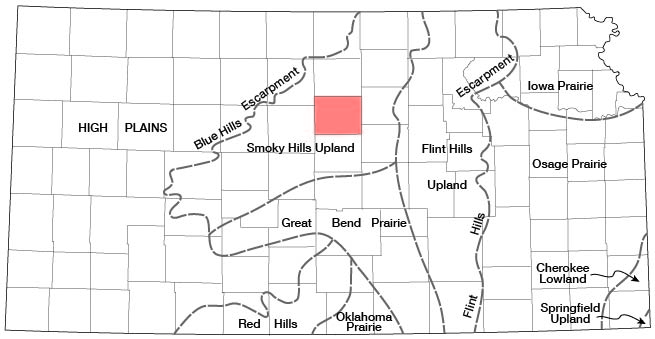
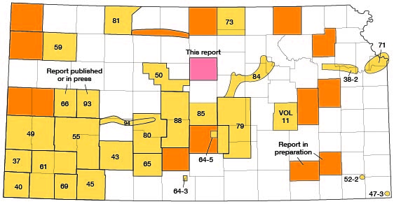
Figure 2--Index map of Kansas showing area described in this report and areas covered by other online geologic reports, as of March 2009. For additional information, please visit the KGS Geologic Maps of Kansas Page.
Methods of Investigation
Field work for this investigation was done during the years 1947 to 1950. During this time all the wells listed in Table 14 were visited and the data regarding them obtained. Water-level measurements were made with a steel tape from a fixed measuring point at the top of the well.
In 1947 John Sears collected data on 50 wells in the Saline River Valley in Lincoln County. Sixteen of these wells were selected as observation wells and periodic measurements of the water levels in them have been made since March 1947. During the field seasons of 1948 and 1949 records of 125 additional wells throughout Lincoln County were collected.
In the fall of 1947, 15 water samples for complete analysis were collected from typical domestic and stock wells and were analyzed in the Quality of Water laboratory of the U. S. Geological Survey at Stillwater, Oklahoma. During the fall of 1948 and the summer of 1949 water samples were collected from 101 additional domestic and stock wells. Of the 101 samples, 88 were analyzed to determine the chloride and nitrate contents and 13 were given complete analyses by Howard Stoltenberg, chemist in the Water and Sewage laboratory of the Kansas State Board of Health.
During the field seasons of 1948 and 1949 a geologic investigation of the county included the following types of work: determination of the thickness and extent of loess; drilling of auger holes at various locations; measurement of stratigraphic sections to determine the thickness of the exposed Cretaceous rocks; and marking all outcrops on aerial photographs and base maps. John Frye spent one week in the summer of 1948 and one week in the fall of 1949 in the field with me helping to work out the stratigraphy. From these data a geologic map (Pl. 1) was prepared. Geologic cross sections (Pl. 3) were prepared from data obtained by drilling 43 test holes through the water-bearing silt, sand, and gravel of Pleistocene age.
These test holes were drilled with the hydraulic rotary drilling machine owned by the State Geological Survey and operated by William T. Connor, Kenneth L. Walters, and Max Yazza. Logs of the test holes were prepared in the field by Walters and the samples were examined microscopically in the office. The wells and test holes shown on Plate 2 were located within the section by use of the odometer and are believed to be accurate to within 0.1 mile. The altitudes of the measuring points of the measured wells and test holes were determined with a plane table and alidade or dumpy level by level parties from the U. S. Bureau of Reclamation and a Geological Survey level party headed by Charles K. Bayne.
Field data used for preparing Plates 1 and 2 were recorded on a base map modified from a map prepared by the State Highway Commission of Kansas. The roads and drainage on these base maps were corrected by field observations and by use of aerial photographs obtained from the U. S. Department of Agriculture.
Well-numbering System
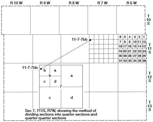
The well and test-hole numbers in this report give the location of wells according to General Land Office surveys and in the following order: township, range, section, 160-acre tract within that section, and the 40-acre tract within that quarter section. If two or more wells are in a 40-acre tract, the wells are numbered serially in the order in which they were inventoried. The 160-acre and 40-acre tracts are designated a, b, c, or d in a counterclockwise direction beginning in the northeast quarter. For example, as shown in Figure 3, well 10-7-7bb is located in the NW NW sec. 7, T. 10 S., R. 7 W.
Figure 3--Diagram of Harper County illustrating the well-numbering system used in this report.
Acknowledgments
Appreciation is extended to the many well drillers, well owners, tenants, and city officials in Lincoln County for their cooperation. This included supplying data relative to the character of materials penetrated in drilling wells, permitting measurement of wells, permitting test drilling on their lands, and supplying data on city-supply wells.
The manuscript for this report has been reviewed critically by several members of the Federal and State Geological Surveys; by Dwight Metzler, Director and Chief Engineer, and Willard O. Hilton, Geologist, Division of Sanitation, Kansas State Board of Health; and by Robert V. Smrha, Chief Engineer, and George S. Knapp, Engineer, Division of Water Resources, Kansas State Board of Agriculture.
The illustrations were drafted by W. W. Wilson of the U. S. Geological Survey. Analyses of the water samples were made by J. Crittendon, R. H. Langford, and L. R. Kister, Chemists, Federal Geological Survey, and Howard Stoltenberg, Chemist, Kansas State Board of Health.
Prev Page--Contents || Next Page--Geography
Kansas Geological Survey, Geology
Placed on web March 5, 2009; originally published July, 1952.
Comments to webadmin@kgs.ku.edu
The URL for this page is http://www.kgs.ku.edu/General/Geology/Lincoln/02_intro.html