![]()
Prev Page--Introduction || Next Page--Geology
Geography
Topography and Drainage
Lincoln County lies in the area designated by Adams (1903) as the Smoky Hills Upland of the Great Plains physiographic province. The topography of this area is related to the differential weathering characteristics of the Cretaceous clay, sandstone, shale, and limestone which account for the prominent topographic features of Lincoln County such as the broad flat alluvial valleys along the major streams, the deep, narrow channels of the tributary valleys, the bold escarpments of the deeply dissected uplands, and the long gently sloping pediments of the uplands.
The highest altitude is 1,800 feet, on the divide between Saline and Smoky Hill Rivers at the Lincoln-Ellsworth County line. The lowest altitude is 1,280 feet, where the valley of Rattlesnake Creek enters Ottawa County. This gives a county-wide relief of 520 feet but the local maximum relief is about 300 feet.
Lincoln County, except locally along the flat terrace of Saline River, is well drained by three major streams and their tributaries: Rattlesnake Creek in the northeast corner, Saline River which is centrally located west to east, and Smoky Hill River which passes through Ellsworth County to the south and drains a small area along the southwestern boundary of Lincoln County. Rattlesnake Creek heads in northwestern Lincoln County, flows in an easterly direction across the northern part of the county, and then southeast to its junction with the Solomon River in Ottawa County. Saline River heads in Thomas County, enters Lincoln County about 7 miles north of the southwest corner, flows in an easterly direction across the county, and then joins Smoky Hill River east of Salina. Smoky Hill River heads in Colorado, flows eastward to a point near Lindsborg, northward to Salina, and again eastward joining with Republican River at Junction City to form Kansas River.
Climate
Lincoln County has moderate precipitation, a wide temperature range, moderately high average wind velocity, and comparatively rapid evaporation. The summer, especially during July and August, is generally hot. The winters are moderately cold, but generally free from excessive snowfall. Climatic data presented below are based on records of the U. S. Weather Bureau.
The normal annual mean temperature is 55.3° F. at Lincoln. January, with a normal mean temperature of 29.2° F., generally has the lowest temperature of the year; July, with a normal mean temperature of 80.5° F., generally has the highest temperature. The highest recorded temperature at this station is 119° F., recorded in July 1934, and the lowest temperature is -25° F., recorded in January and December 1912. The average date of the last killing frost in the spring is April 27, but killing frosts have been recorded as late as May 24. The average date of the first killing frost in the fall is October 14, although killing frosts have been recorded as early as September 20. The average length of the growing season is 170 days.
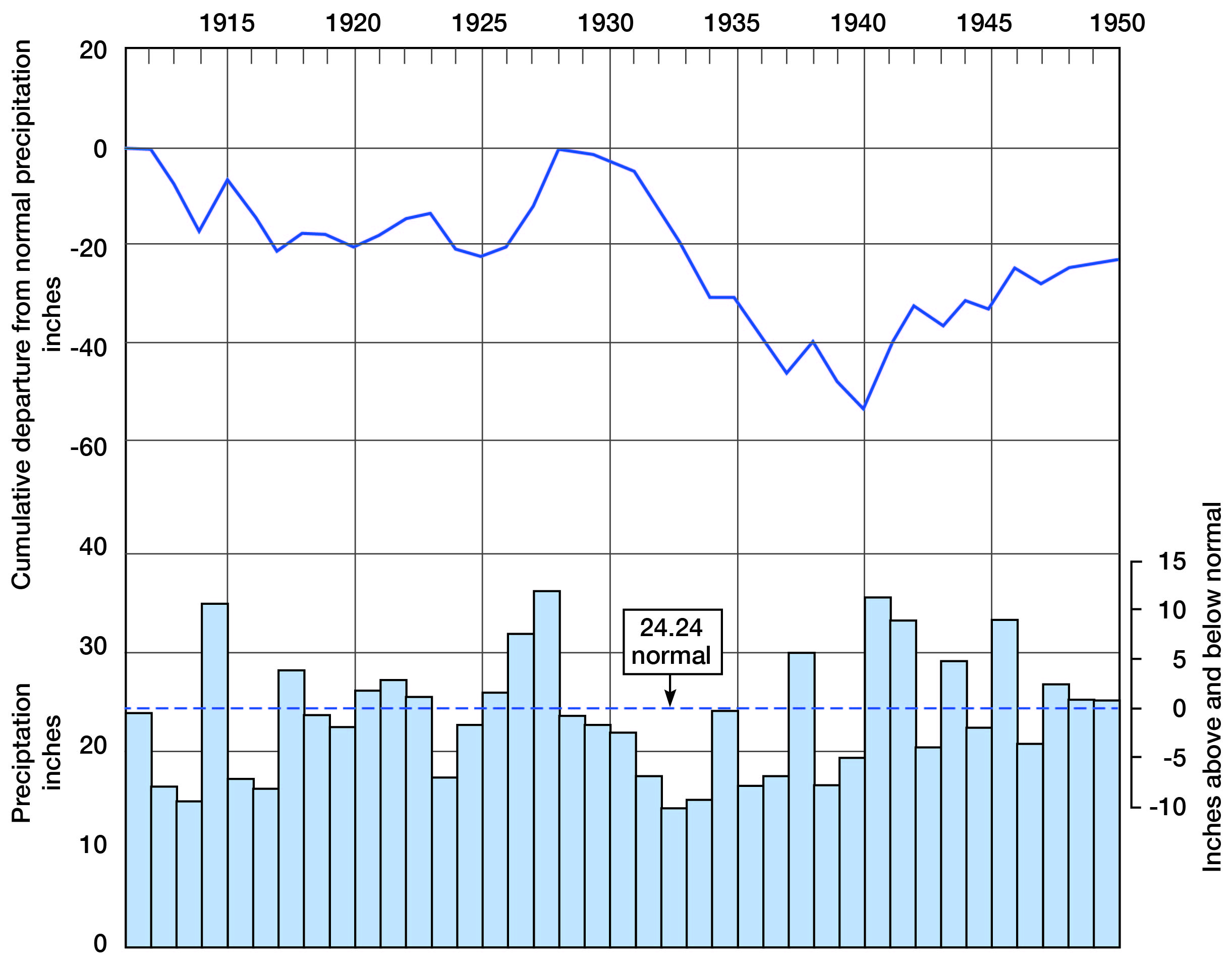
The normal annual precipitation is 24.24 inches; the lowest recorded annual precipitation at Lincoln was 16.37 inches in 1936, and the highest was 35.02 inches in 1915. The annual precipitation and the cumulative departure from normal precipitation at Lincoln are shown graphically in Figure 4. As indicated, deviations from the normal are frequent, and precipitation in the area seems to follow irregular cycles in which periods of excessive precipitation alternate with periods of deficient precipitation or drought. Much of the precipitation falls as heavy rains which are followed by periods of scanty rainfall. Approximately 74 percent of the total annual precipitation falls during the crop-growing season from April through September.
In this area the prevailing wind is from the south, but north winds prevail during January and February. The greatest wind velocity is in March and April after which it decreases until August, which is the least windy month of the year.
Figure 4--Annual precipitation and cumulative departure from normal precipitation at Lincoln.
Population
According to the 1951 county assessors report to the Kansas State Board of Agriculture, the population of Lincoln County is 7,258, an average of 9.9 people per square mile in comparison with 23.6 for the State. [Note: Lincoln County population was listed as 3,578 in 2000 U.S. census, with a density of 5.0 (32.9 for the state) (KU Institute for Policy & Social Research).] In 1951 approximately one-half of the residents of the county lived in four cities. Lincoln, the county seat and largest city, has a population of 1,893 [1,349 in 2000]. The three other cities, Sylvan Grove [324 in 2000], Beverly [199 in 2000], and Barnard [123 in 2000], have populations of 547, 305, and 298, respectively.
Transportation
The railroad network in Lincoln County consists of two branch lines of the Atchison, Topeka, & Santa Fe Railway Co. and one branch line of the Union Pacific Railroad. One branch of the Santa Fe extends from Abilene across the northeast corner of the county to Barnard; the other branch takes a northwest coarse from Salina through Lincoln to Osborne. A branch of the Union Pacific enters the county at Beverly, passes westward through Lincoln, and extends northwestward to Colby in Thomas County, where it joins the main line of the Chicago, Rock Island, & Pacific Railroad Co.
Two hard-surfaced State highways pass through Lincoln County, State Highway 14 through the central part from north to south, and State Highway 18 from east to west through the central part (through Beverly, Shady Bend, Lincoln, Vesper, and Sylvan Grove). The rest of the county is served by improved county and township roads.
Agriculture
Agriculture is the chief industry in Lincoln County. Wheat, sorghum, corn, oats, and hay are the principal crops; the acreage of each for the years 1939, 1944, and 1946 is given in Table 1.
Table 1--Acreage of principal crops grown in Lincoln County.
| Crop | 1939 | 1944 | 1946 |
|---|---|---|---|
| Wheat | 67,000 | 164,000 | 170,000 |
| Sorghum | 37,890 | 38,670 | 30,370 |
| Corn | 13,400 | 17,700 | 12,200 |
| Oats | 7,030 | 5,630 | 6,470 |
| Hay | 3,740 | 6,220 | 5,030 |
| All other crops | 7,686 | 1,832 | 2,607 |
| Totals | 136,746 | 234,052 | 226,677 |
Lincoln County, which has 1,239 farms, comprises 464,640 acres, of which 35 percent is pasture land. Cattle are the predominant livestock; during 1946, 34,000 cattle were raised in or marketed from the county.
The distribution of cultivated and grazing land is controlled by the topography and stratigraphy. Nearly all the crop land lies on the flat loess-mantled uplands and in the alluvial valleys. The grazing land is generally the rolling areas underlain by shale, sandstone, and limestone of Cretaceous age.
Natural Resources
Mineral resources of Lincoln County include clay, construction materials, volcanic ash, and sand and gravel. These resources are fairly extensive, but they are not being developed as fully as is possible.
Clay resources
The clay resources of this area are restricted primarily to the Dakota formation. Plummer and Romary (1947, p. 38) indicate that these clays are important ceramicly because they differ mineralogically from the majority of the clays in Kansas in that they are composed dominantly of the clay mineral kaolinite. Common clay products are bricks, floor, wall, roofing, and sewer tile, refractories, pottery, and whiteware.
The Kiowa shale, which underlies the Dakota formation, and the Graneros shale, which overlies the Dakota, are not desirable for standard structural clay products but are satisfactory for the production of lightweight aggregate. Lincoln County has large quantities of clay and shale suitable for these products.
Construction materials
Besides clay, Lincoln County has several other native materials suitable for construction purposes. Three principal materials are Greenhorn limestone, Dakota quartzite, and sand and gravel.
The Fencepost limestone, an 8- to 10-inch bed at the top of the Greenhorn limestone, is easily recognized by the iron-stained band at the center of the bed. In many parts of Lincoln County quarries have been opened in the Fencepost to obtain material for fence posts and building blocks. The durability of this limestone is demonstrated by the numerous stone buildings throughout the county constructed during pioneer days. This limestone is also crushed and used as road metal.
The Dakota formation contains many thick lenticular channel sandstones. Locally many of these channel sandstones are cemented by calcite, iron oxide, or dolomite (Swineford, 1947). At some localities in Lincoln County sandstones cemented with each of these minerals are found. The calcite-cemented sandstone is known locally as "Lincoln quartzite" because of its abundance near the town of Lincoln. It has been used extensively for road metal, railroad ballast, and high-quality concrete aggregate. The iron oxide-cemented sandstone, which has a tendency to case-harden upon exposure to the atmosphere, has been used for building stone, road metal, and riprap on stock-pond dams. Another type, dolomitic calcite-cemented sandstone, has essentially the same occurrence and use.
At the present time quartzite is produced from two quarries, one 1 mile south of Lincoln and the other 5 miles west of Sylvan Grove. The county has large reserves of this material.
Both quartz gravel and locally derived gravel are produced in the county. The principal source of the quartz sand and gravel is the channel fill of Meade age in southwestern Lincoln County. This sand and gravel is also used as road-surfacing material and for concrete aggregate.
The locally derived gravel contains more silt and clay than the quartz gravel and is more common throughout the county. It occurs in terraces along the major streams and tributaries. This type of gravel is satisfactory only for road surfacing; many of the county and township roads have been surfaced with it.
Volcanic ash
The only extensive deposits of volcanic ash in Lincoln County are in sec. 27, T. 13 S., R. 10 W. (Carey and others, 1952). Surface exposures indicate that the deposit extends under a large part of this section and ranges from 3 to 12 feet in thickness. Two pits have been opened and a small quantity of ash is mined for ceramic uses.
Volcanic ash has been used as an abrasive, particularly in scouring compounds and soaps; as an important ingredient of ceramic glazes and in ceramic bodies; as an additive to cement; as a raw material for manufacture of several types of lightweight aggregates; as a sweeping compound; as a dressing for some types of bituminous-mat highways; and it may be usable as a raw ingredient in glass, as a filler, and for many potential future uses.
The uncertainty with which an explorer may find deposits of volcanic ash may be explained by the theory explaining the source and distribution of volcanic dust. Volcanic dust was thrown explosively into the air somewhere in the Rocky Mountain belt, perhaps in north-central New Mexico (Swineford, 1949), and was carried by winds over Kansas and adjacent areas. The ash shards settled to the ground, or were carried down by rains, resulting in a thin layer of fine-textured ash spread extensively over the surface. This thin surface layer of material served to overload the streamlets leading into ponds or depressions on aggrading valley flats and rarely in upland situations. These small tributaries were able to carry material which was predominantly ash into the depressions until they had cleared at least a part of their drainage areas. Thus deposits of volcanic ash are found in or adjacent to abandoned streamlets or valley fills.
Prev Page--Introduction || Next Page--Geology
Kansas Geological Survey, Geology
Placed on web March 5, 2009; originally published July, 1952.
Comments to webadmin@kgs.ku.edu
The URL for this page is http://www.kgs.ku.edu/General/Geology/Lincoln/03_geog.html