![]()
Prev Page--Subsurface rocks || Next Page--Structure
Geology and Ground-water Characteristics of Outcropping Rock Units
The previously described Pennsylvanian rocks crop out in Kansas east of Cowley County. Mississippian rocks of the Osagian Series crop out in extreme southeast Kansas; younger Mississippian rocks are absent at the surface, owing to post-Mississippian erosion. Rocks that crop out in Cowley County are listed in Table 3 and are discussed on the following pages.
Table 3--Generalized section of outcropping rock units in Cowley County and their water-bearing characteristics. The stratigraphic nomenclature is that of the State Geological Survey of Kansas.
| System | Series | Subseries | Stage | Formation or rock unit |
Thickness (feet) |
Character | Water supply |
|---|---|---|---|---|---|---|---|
| Quaternary | Pleistocene | Upper Pleistocene |
Recent | Alluvium | Silt, clay, and arkosic sand and gravel in Arkansas River valley. Silt, clay, sand and chert gravel in other stream valleys. | Large quantities of water of good to poor quality available in Arkansas River valley. Moderate to small quantities of water in other stream valleys. | |
| Wisconsinan | Eolian Silts |
0-30 | Wind-deposited silt generally in upland position. Locally may contain silt older than Wisconsinan age. | Lies above water table and yields no water to wells. | |||
| Terrace Deposits |
0-55 | Silt, clay, and arkosic sand and gravel in Arkansas River valley. Silt, clay, sand, and chert gravel in other major stream valleys. | Large quantities of water of good to poor quality available in Arkansas River valley. Small to moderate supplies of hard water available in other major stream valleys. | ||||
| Sangamonian and Illinoisan |
Crete and Loveland Formations |
0-55 | Upper part principally silt and sandy silt. Lower part silt, clay, and arkosic sand, and some gravel in Arkansas River valley. Locally in Walnut River valley these deposits contain chert gravel. | In Walnut River valley these deposits are above the water table and yield no water. In Arkansas River valley moderate supplies of water of good quality are available. | |||
| Lower Pleistocene |
Yarmouthian and Kansan |
Sappa and Grand Island Formations |
0-40 | Upper part silt and sandy silt. Lower part silt, clay, and arkosic sand and gravel in deposits associated with Arkansas River valley. In Walnut River valley and other major streams these deposits contain silt, clay, and chert gravel. | Chert gravel deposits lie above water table. Arkosic deposits yield small to moderate quantities of water of good quality. Locally these deposits are above the water table and yield no water to wells. | ||
| System | Series | Group | Formation | Member | Thickness (feet) |
Character | Water supply |
| Permian | Middle Permian |
Sumner | Wellington | Hollenberg Limestone |
0-80 | Light-gray, green, and some red silty calcareous shale. Contains a few discontinuous limestone beds of which the Hollenberg Limestone seems to be fairly persistent. Locally, thin seams of gypsum occur in lower part. | Generally a poor aquifer, but some hard water may be obtained from the upper, weathered part near the outcrop. Locally, some water is obtained from the Hollenberg bed and from solution channels in gypsum. |
| Lower Permian |
Chase | Nolans Limestone |
Herington Limestone |
10-15 | Light-buff limestone and dolomite in upper part. Dolomitic and sandy in appearance; contains calcite geodes. Locally, limestone contains chert. | Locally yields small to large quantities of water of good to poor quality from the upper part, which locally contains solution channels. Little, if any. water is obtained from the middle and lower members. | |
| Paddock Shale |
7-10 | Blue and gray calcareous shale; contains some impure limestone. | |||||
| Krider Limestone |
4-9 | An upper and a lower, thinner, more dense limestone separated by gray and buff calcareous shale. | |||||
| Odell Shale |
30-38 | Chiefly gray and green calcareous shale. Locally, dolomitic zones occur in upper and middle parts. | Yields little water to wells in the area. | ||||
| Winfield Limestone |
Cresswell Limestone |
30± | Upper part light-blue limestone, thin bedded, weathers white; shaly in part. Lower part of Cresswell Member massive light-buff limestone generally in two beds with very thin shale parting, but may be one massive bed 12-15 feet thick; weathers light gray to gray. Locally may contain some chert. | Locally yields small to moderate quantities of water to wells from weathered upper part. | |||
| Doyle Shale |
Gage Shale |
40-50 | Gray, green, and maroon clay shale, limy and concretionary in upper few feet. | Locally, in subsurface, large to moderate supplies of water of good to poor quality are available from solution channels in uppermost few feet. Some water is available from limestone beds near base and from the Towanda. Quality of water ranges from good to poor. | |||
| Towanda Limestone |
2-15 | Buff to gray limestone, in part platy to slabby. Resistant bed near base. Locally forms bench on Doyle slope. Not well exposed. | |||||
| Holmesville Shale |
25-35 | Light-gray to green shale containing thin limestone beds in lower part. | |||||
| Barneston Limestone |
Fort Riley Limestone |
45-55 | Light-buff limestone weathering light gray, thin bedded in upper part, shaly near middle part, and thick bedded in lower part. A few thick beds occur just above shaly middle part. | Upper weathered zone of Fort Riley yields small to moderate supplies of hard water to wells. Middle and lower zones yield small to large quantities of water to wells and springs from solution channels in local areas. Florence yields small to large supplies of water to wells and springs unless drained near outcrop area. | |||
| Florence Limestone |
12-35 | Thick-bedded buff limestone interbedded with gray and blue chert. Lower part contains more limestone and some limy shale. Chert is nodular and occurs in bands separated by limestone containing little chert. | |||||
| Matfield Shale |
Blue Springs Shale |
20-30 | Buff limy shale containing thin limestone bed in upper part. | Yields small supplies of water to wells from Kinney Limestone Member in local area. | |||
| Kinney Limestone |
13-18 | Two limestones separated by 8 to 10 feet of gray limy shale. Upper limestone variable in thickness; lower limestone hard, massive, and almost uniform in thickness. | |||||
| Wymore Shale |
10-15 | Gray and maroon shale, in part limy. | |||||
| Wreford Limestone |
Schroyer Limestone |
6 | Limestone: an upper algal zone, which weathers to a pitted surface, a shaly limestone zone, and a lower cherty limestone. | Yields small to moderate quantities of hard water to wells in and west of outcrop area. Water principally from weathered and fractured zones. | |||
| Wreford Limestone |
Havensville Shale |
5-8 | Limy shale, including a persistent cherty limestone near the middle, which weathers to a pitted surface. | Yields small to moderate quantities of hard water to wells in and west of outcrop area. Water principally from weathered and fractured zones. | |||
| Threemile Limestone |
17-19 | An upper algal limestone weathering to a pitted surface, cherty limestone, shaly limestone, and a lower cherty limestone. | |||||
| Council Grove |
Speiser Shale |
25-35 | Shale, red and green in lower part and gray in upper part; uppermost few feet contains thin limestone beds. Locally a sandstone is present in the lower middle part. | Sandstones may yield small quantities of water to wells locally. Little or no water is obtained from shales. | |||
| Funston Limestone |
9-12 | Limestone at top, bluish gray; shale and limestone in middle part; and dense gray limestone at base. This basal bed breaks into large blocks on the outcrop. | Yields little or no water to wells. | ||||
| Blue Rapids Shale |
17-22 | Shale, gray, containing a red zone in upper part, in part limy: a thin limestone below the red zone; a gray clay shale below. | Yields little or no water to wells. | ||||
| Crouse Limestone |
8-12 | An upper and a lower limestone bed separated by a thin shaly limestone bed. Upper and lower beds contain some chert. | Not a good aquifer but locally yields small quantities of hard water to wells. | ||||
| Easly Creek Shale |
10-15 | Mostly red shale but some gray shale in uppermost part and in lower part. | Yields no water to wells in the area. | ||||
| Bader Limestone |
Middleburg Limestone |
5-8 | Limestone; upper part thin bedded to platy, containing some shale, lower part slabby to massive. | Locally yields small quantities of hard water to wells and springs. | |||
| Hooser Shale |
3-9 | Shale, gray, green, buff, and locally some red. | |||||
| Eiss Limestone |
8-10 | Two limestones separated by shale. Upper limestone is dense and massive. Shale is gray and limy. Lower limestone is earthy and dense. | |||||
| Stearns Shale |
6-10 | Gray and green shale, in part limy. Locally contains some red shale. | Yields no water to wells in the area. | ||||
| Beattie Limestone |
Morrill Limestone |
3-9 | Limestone, thin bedded or slabby to massive, upper part algal. | Yields very small quantities of hard water to a few wells and springs. Supplies are generally inadequate. | |||
| Florena Shale |
2.5-11 | Limy shale, gray brown and bluish gray, very fossiliferous. | |||||
| Cottonwood Limestone |
5-6 | An upper white massive to slabby limestone and a gray shale or shaly limestone. A lower massive limestone, locally siliceous. | |||||
| Eskridge Shale |
21-35 | Shale, gray and green in upper part and red in lower part. Limy and very fossiliferous in upper part. | Yields little or no water to wells in the area. | ||||
| Grenola Limestone |
Neva Limestone |
17-25 | Limestone interbedded with thin shale layers, weathers gray to buff, contains some chert in upper part. | Yields small to moderate quantities of hard water to wells and springs locally, principally from Neva Member. | |||
| Salem Point Shale |
6-10 | Gray to brown shale, in part limy. | |||||
| Burr Limestone |
4-7 | Blue-gray, dense limestone; generally two beds separated by a thin shale. | |||||
| Legion Shale |
3-8 | Buff, limy shale. | |||||
| Sallyards Limestone |
3-4 | Bluish-gray, massive to platy limestone, massive in tipper part, thin bedded in lower part. | |||||
| Roca Shale |
10-15 | Shale, gray in upper part and red and green in lower part; in part, limy. | Yields no water to wells in the area. | ||||
| Red Eagle Limestone |
Howe Limestone |
20 | Limestone, upper part massive; middle part thin-bedded limestone layers separated by very thin shale partings; lower part very thin limestone, which may be absent locally. | Locally may yield small quantities of hard water to wells front weathered upper part of unit near the outcrop. | |||
| Bennett Shale |
|||||||
| Glenrock Limestone |
|||||||
| Johnson Shale |
20-30 | Varicolored shale, limy to very limy in lower part. | Yields no water to wells in the area. | ||||
| Foraker Limestone |
Long Creek Limestone |
8-12 | Gray to tan linestone, weathering to nearly white; massive to flaggy lower part contains chert. | Locally yields small to moderate quantities of hard water to wells and springs, principally from the Hughes Creek Shale Member. | |||
| Hughes Creek Shale |
25-35 | Limestone and cherty limestone. Upper bed forms bench and breaks off in great slabs. Lower part contains shale. | |||||
| Americus Limestone |
9 | Two dense blue cherty limestones separated by shale. | |||||
| Admire | Janesville Shale |
Hamlin Shale |
40-47 | Two shale units separated by an earthy limestone. Upper shale is brown grading to dark gray, lower is green and red. | Generally a poor aquifer; locally may yield small quantities of hard water from channel sandstones and from the Falls City and Aspinwall. locally, seeps may occur in the Towle. | ||
| Five Point Limestone |
2-4 | Massive dark-brownish-gray limestone weathering yellow orange. | |||||
| West Branch Shale |
12-14 | Greenish-gray to bluish-gray shale; locally contains limestone stringers. | |||||
| Falls City Limestone |
3-5 | Earthy, dense, dark-blue to gray limestone, weathering yellow orange. Massive in lower part and slabby in upper part. | |||||
| Onaga Shale |
Hawxby Shale |
35-45 | Shale, gray in upper part, varicolored in lower part. Locally contains a channel sandstone. | ||||
| Aspinwall Limestone |
1-3 | Gray to blue-gray limestone weathering yellow orange. Dense but somewhat slabby, locally containing shale streaks. | |||||
| Towle Shale |
13-20 | Yellow and gray shale, locally sandy and limy. | |||||
| Pennsylvanian | Upper Pennsylvanian |
Wabaunsee | Wood Siding |
Brownville Limestone |
1-2 | Dense blue-gray limestone, weathering yellow orange or yellow brown. | Generally a poor aquifer, but locally may yield small quantities of water of poor quality from sandy zones. |
| Pony Creek Shale |
15-20 | Shale, gray brown in upper part, grading downward to yellow gray. May contain a thin coal seam locally. | |||||
| Grayhorse Limestone |
2-4 | Massive buff limestone, weathering yellow brown. | |||||
| Plumb Shale |
20 | Blue-gray to yellow-gray shale, locally sandy and limy. | |||||
| Nebraska City Limestone |
1-2 | Blue-gray dense limestone, weathering buff orange. | |||||
| Root Shale |
French Creek Shale |
30-35 | Gray and blue-gray shale; locally contains sandstone. | Generally a poor aquifer. Locally small quantities of water of poor quality are obtained from sandstone in upper part. | |||
| Jim Creek Limestone |
1-2 | Dark-blue to blue-gray massive, dense limestone. | |||||
| Friedrich Shale |
18-35 | Gray to blue-gray shale, sandy at top; contains sandstone locally in upper part. Coal occurs locally near top. | |||||
| Stotler Limestone |
Grandhaven Limestone |
4-6 | Several limestone beds separated by shale. Blue-gray limestone weathering to rusty brown. | Generally a poor aquifer, but in places small quantities of water of poor quality may be obtained from weathered part of lower unit. | |||
| Dry Shale | 5-7 | Gray and brown clay shale, locally limy. | |||||
| Dover Limestone |
8-10 | Blue-gray limestone beds separated by shale. Locally, coal occurs in shale below upper limestone. | |||||
| Pillsbury and Willard Shales |
10-15 | Varicolored shale, commonly blue gray. A persistent impure limestone occurs below the middle part; coal commonly occurs near top and bottom of the formation. | Locally yields small quantities of water of poor quality to shallow wells. | ||||
| Emporia Limestone |
Elmont Limestone |
2-5 | Blue-gray limestone, locally massive. | Small quantities of water of good to poor quality available, principally from the sandstone in the shale member. | |||
| Harveyville Shale |
10-14 | Gray shale, commonly contains coal in upper part. Locally, sandstone occurs in middle part. | |||||
| Reading Limestone |
6-10 | Several thin limestones separated by shale layers. | |||||
| Auburn Shale |
5-10 | Green-gray to gray shale, locally containing thin limestone beds. | Yields little or no water to wells in the area. |
Pennsylvanian System--Upper Pennsylvanian Series
Wabaunsee Group
The rocks of the Wabaunsee Group constitute the uppermost rocks of Pennsylvanian age in Kansas. The lower boundary of this group is placed at the, top of the Topeka Limestone, and the upper boundary is placed at the unconformity at the base of the Indian Cave Sandstone where this unconformity is observable, or, in areas where the Indian Cave is absent, as in Cowley County, at the top of the Brownville Limestone Member of the Wood Siding Formation.
Total thickness of the Wabaunsee Group in Cowley County is about 500 feet, but only the upper 200 feet crops out within the county. These deposits are characterized by alternating thin limestone beds and relatively thick shale units containing some sandstone and coal. The Wabaunsee Group includes six limestone formations and six shale formations (Moore and Mudge, 1956), but only three limestone units (Emporia, Stotler, and Wood Siding) and three shale units (Auburn, Pillsbury-Willard, and Root) crop out in Cowley County, where they can be seen in only a part of Townships 33, 34, and 35 in Range 8. Because they are poorly exposed, the units were not shown separately on the geologic map (Pl. 1). The oldest rocks exposed in the county are assigned to the Auburn Shale. The Auburn is exposed only in cuts adjacent to streams along the county line near Cedarvale, where it is composed chiefly of gray shale containing sandstone in the upper part. Outcrops of the overlying units of the Wabaunsee Group are poorly exposed and most of them consist of small, more resistant limestone ledges adjacent to streams. These exposures generally extend only short distances laterally, and rarely are they complete sections of the units. Coal is present in some of these exposures and has been mined for local use in three localities adjoining Cedar Creek valley; it is found in the Willard and Pillsbury Shales and in the Harveyville Shale Member of the Emporia Limestone.
Small quantities of hard water are obtained from shallow wells in sandstones in the upper part of the Wabaunsee. Two wells in and near sec. 30, T. 34 S., R. 8 E., obtain fresh water (Table 11) from a sandstone in the Willard and Pillsbury Shales at a depth of about 360 feet, but water from this sandstone in nearby areas is too mineralized for use.
Permian System--Lower Permian Series
Admire Group
The Admire Group consists chiefly of clastic deposits but contains thin beds, of limestone and some sandstone. Shale predominates in this group of rocks, and the relative softness of the rock is evident in the steep soil-covered slopes, on which the limestone units are evident only as small soil-covered benches. The Admire occupies the steeply inclined slope beneath the scarp-forming Foraker Limestone. The Admire Group has been divided by Moore and Mudge (1956) into three formational units, which in ascending order are the Onaga Shale, Falls City Limestone, and Janesville Shale. In Cowley County the Admire Group has an almost uniform thickness of about 130 feet.
The scale of the map and the discontinuity of the exposures of the Admire Group necessitated mapping the entire group as a unit; it is shown by the symbol Pa1 on Plate 1.
Onaga Shale
The Onaga Shale is composed of three members: The Towle Shale at the base, the Aspinwall Limestone, and the Hawxby Shale at the top. Thickness of the Onaga ranges from 50 to 70 feet in the county.
The Towle Shale Member is composed chiefly of red and gray shale, which is sandy in some places. The thickness of the unit ranges from about 13 to 20 feet.
The Aspinwall Limestone Member commonly forms the lowest bench on the steep slope of the Admire outcrop. This unit is composed of limestone in the upper part and shaly limestone in the lower part. Mollusks and productid brachiopods are common in the upper part. In Cowley County the thickness of this unit ranges from 1 to 3 feet or slightly more.
The Hawxby Shale Member is chiefly a gray shale, but it contains some red shale in the lower part and a lenticular sandstone in the upper part. Its thickness in the county ranges from 35 to 45 feet.
Natural gas is produced from sandstone in the Admire Group, and although the sandstone in the Hawxby Shale Member has not been definitely correlated with the gas-producing sandstone, it is believed to be the principal producer of natural gas in the area. The helium content of the gas from some wells in the Admire is relatively large (as much as 2 percent) compared to the natural gas from other wells, which may contain only a trace of helium.
A few springs issue from the sandstone in the Hawxby, but no wells are known to obtain water from this sandstone. Small yields of good water probably could be obtained from it near the outcrop, but owing to the topographic location of the outcrop and to the small demand for water in this area, which is principally grassland, this source of water has not been utilized.
Falls City Limestone
The Falls City Limestone is composed of an upper thin slabby unit, a middle massive unit, and a lower slabby to platy unit. The limestone is gray to blue gray and weathers yellow orange. The upper two units are hard, brittle limestone, which breaks into conchoidal chips and contains fragments of crinoid stems and sparse mollusks and brachiopods. The thickness of the formation ranges from about 3 to 5 feet in exposures in the county.
Little if any water is available to wells from the Falls City Limestone.
Janesville Shale
The Janesville Shale is composed chiefly of clastic deposits. Two shale members and one limestone member having an aggregate thickness of about 54 to 64 feet make up this unit.
The lowermost member, the West Branch Shale, is about 20 feet thick and is composed of greenish-gray to bluish-gray and red shale containing some sandy shale and, locally, sandstone in the upper part.
The Five Point Limestone Member, which overlies the West Branch, is a massive to slabby limestone, which is dark brownish gray to blue gray on fresh breaks and yellow orange on weathered exposures. Mollusks and brachiopods are common throughout the bed. The Five Point generally forms the first bench below the Foraker Limestone on the slope of the Admire outcrop, but exposures of the limestone are rare. The thickness of this member ranges from 2 to 4 feet in the few exposures in the county.
The Hamlin Shale Member, the uppermost member of the Admire Group, is chiefly dark-gray clastic material, though it contains some red shale, and in some places it contains sandstone in the lower part. An impure yellow-brown porous limestone (Houchen Creek bed) lies 10 to 20 feet below the top of the Hamlin. In some places this bed forms a bench on the Admire slope, but rarely, except in fresh cuts, is it exposed.
Part of the gas produced from the Admire in Cowley County is probably obtained from the sandstone lenses in the Janesville Shale, but these sandstone bodies are not as continuous as those in the Hawxby Member of the Onaga and are not as productive.
Water in small quantities is probably available near the outcrop of the sandstone bodies in the Janesville, but none of the Wells visited utilized this source of supply. Logs of deep wells in the upland area west of the outcrop of the Foraker Limestone do not record water from these sandstone bodies.
Council Grove Group
The Council Grove Group comprises seven shale formations and seven limestone formations having a total thickness in Cowley County of about 300 feet. The rocks that make up this group have a much different appearance on the outcrop than those of the underlying Admire and Wabaunsee Groups. The limestone formations are generally much thicker than those of the underlying groups, and the limestones of the Council Grove weather gray to nearly white instead of the characteristic tan brown of the Admire limestones. Most limestone units in the Council Grove Group contain chert, whereas those of the underlying groups contain little if any chert. The rock units of the Council Grove Group are discussed in ascending order.
Foraker Limestone
The three members that compose the Foraker Limestone are, in ascending, order, the Americus Limestone, Hughes Creek Shale, and Long Creek Limestone. The thickness of the Foraker in Cowley County is about 50 feet. The formation is characterized by thick-bedded limestones containing much chert and minor amounts of shale and shaly limestone. The chert is interstratified with the limestone beds and commonly appears as nodular and lenticular masses parallel with the bedding planes. The chert is blue gray on fresh breaks but tan where weathered. An outstanding characteristic of the Foraker is the presence of many large fusulinids in both the chert and the limestone. In some places the thin beds are composed almost entirely of fusulinids. The presence of these fossils in the chert and the topographic position of the Foraker as the capping rock above the steep slope formed on the Admire and Wabaunsee rocks serve to identify it in southern Kansas.
The Foraker Limestone and the overlying Johnson Shale are shown on Plate 1 by the symbol Pcg1.
A representative section through the Foraker Limestone, measured along the railroad cut about a quarter of a mile east of the east line of Cowley County, in sec. 3, T. 31 S., R. 8 E., is given below:
| Permian System--Lower Permian Series | Thickness (feet) |
||||
|---|---|---|---|---|---|
| Council Grove Group | |||||
| Johnson Shale | |||||
| Shale, gray; contains thin limestone streaks and many fossils | 26± | ||||
| Foraker Limestone | |||||
| Long Creek Limestone Member | |||||
| Limestone, thin bedded to slabby in upper part; some massive limestone in lower part; contains many small fusulinids | 10.1 | ||||
| Hughes Creek Shale Member | |||||
| Limy shale to shaly limestone, thin bedded, soft | 5.0 | ||||
| Limestone, cherty, massive, thick bedded in part; contains many large fusulinids | 15.0 | ||||
| Shale, gray; contains thin beds of limestone | 9.6 | ||||
| Americus Limestone Member | |||||
| Limestone, dark blue gray, dense; fusulinids in upper part, a few small chert nodules in middle part | 4.3 | ||||
| Shale, dark gray to nearly black | 1.8 | ||||
| Limestone, blue gray; fusulinids abundant near top, small rounded pebbles in lower part | 2.5 | ||||
| Total thickness of Foraker Limestone | 48.3 | ||||
| Admire Group | |||||
| Janesville Shale | |||||
| Hamlin Shale Member | |||||
| Shale, dark gray | 4+ | ||||
In Cowley County the Americus Limestone Member of the Foraker Limestone is composed of dense blue-gray limestone, 4 to 9 feet thick. The unit generally consists of two limestone layers separated by gray to very dark gray shale. Chert nodules are common in the upper limestone, and fusulinids are present in both limestone layers.
The Hughes Creek Shale Member overlies the Americus. In northern Kansas this unit is a gray to dark-gray shale, but in southern Kansas it contains much limestone and chert. In Cowley County the Hughes Creek is composed of shaly limestone, limestone and chert ' and gray shale. The upper part of the unit is composed of massive to thin-bedded light-gray limestone containing much chert in the thick-bedded units. Fusulinids are present in both the limestone and the chert. In Cowley County the Hughes Creek ranges in thickness from 25 to 35 feet.
The Long Creek Limestone, the uppermost member of the Foraker Limestone, is composed of gray to tan limestone, which weathers light gray to nearly white. The Long Creek is generally more slabby and thin bedded than the underlying members of the Foraker. This unit contains sparse chert and is less resistant to weathering than the Hughes Creek or Americus; hence its outcrop may be a considerable distance back from the escarpment formed by the Hughes Creek and Americus. Small fusulinids are present throughout the Long Creek. A massive bed about 1 foot thick, which lies near the base of the Long Creek, characteristically breaks into huge slabs that form a conspicuous belt along the outcrop. In Cowley County, the Long Creek ranges in thickness from about 8 to 12 feet.
A few wells obtain water from the Foraker in northeastern Cowley County. Yields are generally small and the water is hard but otherwise good. Springs along the outcrop in northern and central Cowley County yield water from the Foraker, but inasmuch as yields from these springs are dependent on weather conditions, they fluctuate greatly with the wet and dry seasons; many of the springs cease flowing in late summer. A spring in the NW cor. sec. 29, T. 32 S., R. 8 E. (32-8-29bbb, Table 11) flowed at an estimated rate of 50 gpm (gallons per minute) in early June 1958, but flow had diminished to about 5 gpm in late August 1958. Logs of holes drilled for oil in southeast Cowley County do not record water in the Foraker.
Johnson Shale
In Cowley County the Johnson Shale ranges in thickness from about 20 to 30 feet and is composed of shale containing thin beds of limestone. The formation is poorly exposed in the county, occupying the grassy slope between the Foraker Limestone below and the Red Eagle Limestone above. The upper few feet of the Johnson is composed of dark-gray shale overlying about 10 feet of gray shale containing thin nodular beds of limestone; the lower part is composed of very limy shale. Fossils are generally abundant in the upper part of the formation, pelecypods and productid brachiopods being the most abundant.
Red Eagle Limestone
The Red Eagle Limestone is about 20 feet thick in Cowley County. In northern Kansas two limestone members and an intervening shale member are recognized, but in Cowley County the formation is almost entirely limestone; the members are separable in the county, however, according to their faunal and lithologic character.
The Red Eagle Limestone and the overlying Roca Shale are shown on Plate 1 by the symbol Pcg2.
A section measured by O'Connor and Jewett (1952) in a road cut along Kansas Highway 38 in sec. 21, T. 32 S., R. 8 E., is given below:
| Permian System--Lower Permian Series | Thickness (feet) |
||||
|---|---|---|---|---|---|
| Council Grove Group | |||||
| Red Eagle Limestone | |||||
| Howe Limestone Member | |||||
| Limestone, speckled gray, tan, and brown; spergenite of shell fragments, ostracodes, bryozoans, gastropods, echinoid fragments, and fusulinids (exposed) | 2.8 | ||||
| Bennett Shale Member | |||||
| Limestone, tan gray, fine grained | 6.4 | ||||
| Limestone, massive, hard, part brecciated; light to medium gray; dark-brown fossil molds; contains sparse bryozoans, fusulinids, ostracodes, foraminifers, brachiopods, and echinoderm fragments | 5.1 | ||||
| Shale, gray | 0.1 | ||||
| Limestone, gray, hard, fine to medium crystalline; sparse bryozoans, abundant brachiopod and echinoderm fragments | 3.8 | ||||
| Shale, tan to gray | 0.2 | ||||
| Limestone, medium gray; brachiopods | 1.0 | ||||
| Limestone, medium gray, hard, crystalline | 0.6 | ||||
| Shale, gray to nearly black, very thin bedded; small fusulinids and fragments of Orbiculoidea | 0.2 | ||||
| Glenrock Limestone Member | |||||
| Limestone, grades laterally into limestone nodules interbedded with shale; contains sparse echinoderm fragments, small fusulinids, ostracodes, gastropods, and brachiopods | 0.5 | ||||
| Total thickness of Red Eagle Limestone | 20.7 | ||||
| Johnson Shale | |||||
| Shale, light gray and tan | 0.4 | ||||
| Shale, gray, thin bedded; nodular to limy siltstone and tan-gray to dark-gray thin-bedded shale; upper part contains bryozoans, crinoid fragments, Nucula and other clams, Ambocoelia, Chonetes, abundant Linoproductus, and Juresania | 4.6 | ||||
The Glenrock Limestone is the lowermost member of the Red Eagle Limestone. In Cowley County the Glenrock is probably not more than 1 foot thick and is composed of nodular gray limestone containing fusulinids, brachiopods, bryozoans, gastropods, and ostracodes.
The Bennett Shale member of the Red Eagle Limestone is about 18 feet thick and is almost entirely limestone. The only shale present is in the partings in the limestone and at the base of the member and is generally not more than 0.2 foot thick. The limestone of the Bennett is massive, crystalline, and medium gray, and contains chiefly fusulinids, gastropods, ostracodes, brachiopods, and bryozoans. The lowermost bed of the Bennett contains a persistent Orbiculoidea fauna, which is not found in beds above nor in the underlying Glenrock, hence serves as an aid in identifying the Bennett and Glenrock.
The uppermost member of the Red Eagle is the Howe Limestone. In Cowley County this member is about 2.5 to 3 feet thick in most exposures but may be thicker in the southern part of the outcrop area and in the subsurface. The Howe is a massive, hard, gray-brown to buff limestone. The weathered surface has a granular texture, owing to uneven weathering of the calcareous fossils and the calcite matrix. Tiny gastropods, ostracodes, and fusulinids and fragments of brachiopods are the principal fossils. The buff color and the weathering characteristics aid in the identification of the Howe.
Little if any water is available to wells from the Red Eagle Limestone. Shallow, large-diameter wells in the proper topographic position may yield small quantities of water from the formation, but such wells probably would not provide a dependable supply. Nearly the entire area of outcrop of the Red Eagle is used for grazing, and surface water is generally used.
Roca Shale
The Roca Shale is about 15 feet thick in Cowley County. The formation occupies the grassy slope between the Red Eagle Limestone below and the Grenola Limestone above and is poorly exposed except in road cuts and in small ravines. The Roca is composed of gray to brownish-gray shale containing very thin nodular limestone beds in the upper part and red shale in the lower 10 feet. In some areas the lowermost beds are green.
The Roca is of little or no importance as a source of ground water.
Grenola Limestone
The Grenola Limestone comprises three limestone members and two shale members. The thickness of the formation in the county ranges from about 33 feet in the northern part of the outcrop area to about 54 feet in southern Cowley County. The increase in thickness is due principally to an increase in thickness of the upper member of the formation.
The Grenola Limestone and the rock units above it to the base of the Crouse Limestone are shown on Plate 1 by the symbol Pcg3.
A section measured by N. Gary Lane (1958) along the Santa Fe Railroad and an adjacent small stream in the SE,14 sec. 4, T. 31 S., R. 8 E., is given below:
| Grenola Limestone (35.9 feet) | Thickness (feet) |
|||
|---|---|---|---|---|
| Neva Limestone Member (17.3 feet) | ||||
| 28. | Limestone, massive, wavy bedded, gray chert layer in center; top of limestone contains small Osagia, sparse fusulinids throughout | 2.2 | ||
| 27. | Shale, calcareous, light brown; echinoid spines, fenestrate bryozoans, | 0.7 | ||
| 26. | Limestone, medium bedded, gray, weathers light yellow gray; robust fusulinids, fenestrate bryozoans | 2.1 | ||
| 25. | Limestone, thin bedded, flaggy, light gray; echinoid spines, calcareous foraminifers, fenestrate bryozoans | 1.4 | ||
| 24. | Shale, blocky, very calcareous, light yellow brown; fusulinids, crinoid stems, calcareous foraminifers | 0.5 | ||
| 23. | Limestone, thin bedded, shaly to platy, light gray to whitish brown; abundant fusulinids near base | 1.0 | ||
| 22. | Limestone, thin bedded to medium bedded, gray to light brown; gray chert nodules 1.3 feet below top; fusulinids, ramose bryozoans, large shell fragments, sparse ostracodes | 5.1 | ||
| 21. | Shale, platy, dark gray, two thin, nodular limestone beds at base. Shale contains Composita, Meekella, Dictyoclostus, Hustedia, Chonetina, fusulinids, ramose and fenestrate bryozoans, echinoid spines and plates, sparse conodonts, selacian remains, and Ditomopyge? | 2.2 | ||
| 20. | Limestone, thin bedded, nodular, blue gray; small fusulinids, ramose bryozoans, sparse ostracodes | 2.1 | ||
| Salem Point Shale Member (6.1 feet) | ||||
| 19. | Shale, platy, calcareous, dark gray; a thin, nodular, blue-gray limestone in center containing abundant small high-spired gastropods | 2.4 | ||
| 18. | Limestone, argillaceous, blue gray to dark gray, irregular tubelike nodules on lower bedding plane; contains sparse small well-rounded, light-gray limestone fragments, small gastropods, sparse crinoid stems | 0.2 | ||
| 17. | Shale, platy, dark gray; charophytes, very sparse selacian remains | 0.3 | ||
| 16. | Limestone, nodular, argillaceous, dark gray brown to light yellow brown; numerous small Ammovertella | 0.8 | ||
| 15. | Shale, platy, gray, nonfossiliferous; includes two thin earthy limestone beds containing Aviculopecten, Septimyalina, Pleurophorus, and small gastropods | 1.5 | ||
| 14. | Limestone, wavy bedded, light brownish gray; numerous pectinoid fragments, small high-spired gastropods | 0.2 | ||
| 13. | Shale, blocky, dark gray, brown, nonfossiliferous | 0.7 | ||
| Burr Limestone Member (4.1 feet) | ||||
| 12. | Limestone, dense, limonitic, blue gray; abundant Osagia and small high-spired gastropods; separated from bed 11 by 0.1-foot brown shale parting | 2.6 | ||
| 11. | Limestone, dense, blue gray; abundant Osagia, crinoid stems, small gastropods, ostracodes | 1.3 | ||
| 10. | Limestone, shaly, flaggy, limonitic, brownish gray; large pectinoid fragments, sparse crinoid stems, echinoid spines | 0.2 | ||
| Legion Shale Member (3.8 feet, upper 2.7 feet exposed) | ||||
| 9. | Shale, blocky, slightly silty, hard, light brown to yellow brown; productid spines, abundant Cavellina; two 2-inch limestone beds, dense, earthy, nonfossiliferous, in center | 3.8 | ||
| Sallyards Limestone Member (4.6 feet) | ||||
| 8. | Limestone, medium bedded, limonitic, light gray; very abundant Osagia, small high- and low-spired gastropods | 2.9 | ||
| 7. | Limestone, thin bedded, wavy bedded, argillaceous, grayish brown; sparse large pectinoid fragments | 0.9 | ||
| 6. | Limestone, medium bedded, light gray; small gastropods, ostracodes, small shell fragments | 0.5 | ||
| 5. | Limestone, wavy bedded, yellowish gray to gray, weathers light brown; long pectinoid fragments, sparse small gastropods | 0.3 | ||
| Roca Shale (8.6 feet exposed) | ||||
| 4. | Shale, clayey, blocky, light yellow gray to brown, green mottling at base, nonfossiliferous | 2.1 | ||
| 3. | Shale, clayey, blocky, light maroon | 2.7 | ||
| 2. | Shale, light green, deeply weathered | 0.8 | ||
| 1. | Shale, silty, calcareous, red to light maroon | 3.0 | ||
The Sallyards Limestone is the lowermost member of the Grenola Limestone. This member is a relatively thin limestone composed of bluish-gray, massive to thin-bedded limestone about 3 to 5 feet thick. The Sallyards weathers to a rough, dark-gray surface as a result of differential weathering of the contained fossils and the matrix. Pelecypods, bryozoans, and crinoid fragments are common, and the alga Osagia is common in the upper part.
The Legion Shale Member, which overlies the Sallyards, is about 3 to 8 feet thick. It is composed of gray to buff shale, and in some areas it contains beds of limestone. It is sparsely fossiliferous but contains Osagia in the upper part, and the beds of limestone contain a sparse molluskan fauna. Pelecypods and the brachiopod Juresania are the most common fossils.
The Burr Limestone Member, overlying the Legion, is about 4 feet thick and consists of two massive blue-gray to dark-gray dense limestone beds containing Osagia, separated by a very thin shale. In some places a third limestone, thin and somewhat flaggy, is present in the base.
The Salem Point Shale Member, which overlies the Burr Limestone, consists of gray to dark-gray shale containing thin limestone beds. A "box-work" limestone near the middle of the unit is fairly persistent. The Salem Point contains small gastropods, and pelecypods are present iii the lower part.
The uppermost and most conspicuous member of the Grenola is the Neva Limestone Member. It is buff on fresh breaks, but gray where weathered, and characteristically forms a ledge of very rough limestone on the outcrop. The Neva forms a pronounced bench on the surface between the escarpment formed by the Wreford Limestone and the escarpment formed by the Foraker Limestone (Pl. 7). The Neva thickens southward from about 17 feet in the northern part of the outcrop to about 25 feet in the southern part of the county. The member contains chert in the upper part, and the amount of chert increases to the south. Fusulinids are plentiful throughout the member.
A few wells obtain water from the Grenola in the vicinity of Grand Summit. Yields are generally small and the water is hard but otherwise good (Table 6). Small springs issue from the Grenola, principally from the Neva Member, in the northern part of the area of outcrop. Flow from these springs is dependent on weather conditions; many of the springs cease flowing in periods of prolonged drought. No wells or springs were observed that obtain water from the Grenola in the southern part of the county.
Eskridge Shale
The Eskridge Shale is composed principally of gray, red, and green shale but also contains some limestone. The formation is poorly exposed, as it occupies the lower part of the grassy slope between the Grenola Limestone and the Crouse Limestone. A persistent limestone about 1 foot thick, in the lower middle part of the formation, in some places forms the lowest small bench on the slope between the Grenola and the Crouse. The Eskridge ranges in thickness from about 21 feet in the northern part of the county to about 35 feet in the southern part. Locally the upper part is very fossiliferous. The Eskridge is of little importance as an aquifer.
Beattie Limestone
The Beattie Limestone is composed of two limestone members and one shale member. Its total thickness ranges from about 22 feet in the northern part of the county to about 11 feet near the south boundary. The Beattie forms a small bench near the middle of the grassy slope between the Grenola and the Crouse (Pl. 7). The formation is poorly exposed, in road cuts and small ravines, for only short distances laterally.
The lowermost member of the Beattie Limestone is the Cottonwood Limestone Member, which maintains a uniform thickness of about 5 or 6 feet across most of the state. In northern and central Kansas the Cottonwood is a light-buff to nearly white massive limestone containing abundant fusulinids, but in the southern part it becomes shaly. Generally, exposures in Cowley County are composed of thin limestone layers and interbedded thin calcareous shale layers containing a large variety of fossils. This fauna is similar to that of the overlying Florena Shale Member. Thickness of the Cottonwood ranges from about 6 feet in northern Cowley County to about 5 feet in the southern part. The Cottonwood maintains a thickness of 5 feet for about 20 miles into Oklahoma and there thins to only a few inches.
The Florena Shale Member, overlying the Cottonwood, is composed of gray to dark-gray shale containing a rich fauna. Chonetes granulifer is abundant in the outcrop area, and other brachiopods, pelecypods, bryozoans, and small trilobites are common. The Florena thins from about 11 feet in northern Cowley County to about 2.5 feet near the southern border.
The uppermost member of the Beattie Limestone is the Morrill Limestone, which commonly is about 3.5 feet thick in the southern part of Cowley County but may be as much as 9 feet thick in the northern part, where it may be divided into three units. The upper of these three units is a whitish irregular-bedded limestone containing algae. The middle unit is composed of massive bluish-gray limestone, which weathers to a light-gray, deeply pitted surface. The outcrop of this bed has a very rough appearance caused by the weathering out of softer material filling vertical borings in the rock. The lower unit of the Morrill is a buff thin-bedded nodular limestone interbedded with fossiliferous shale. Only the lowermost two beds were observed in the southern part of the county.
A few wells obtain small quantities of water from the Beattie Limestone in Cowley County, but the formation is of little importance as an aquifer. On some exposures small seeps issue above the Florena Shale Member. These seeps support a line of shrubs or brush along parts of the outcrop of the Beattie.
Stearns Shale
The Stearns Shale is principally gray shale but it contains some red shale near the middle and some nodular limestone in the upper and lower parts. The thickness of the formation ranges from about 6 to 10 feet in the county. Brachiopods and pelecypods are present in the nodular limestone of the upper part. The formation is poorly exposed and occupies the slope between the underlying Beattie Limestone and the overlying Bader Limestone. The Stearns is of no importance as an aquifer in the county.
Bader Limestone
The Bader Limestone is composed of two limestone members and one shale member having a total thickness of about 26 feet in Cowley County. The Bader forms a small bench on the upper part of the slope between the Crouse Limestone and the Grenola Limestone. The Bader is poorly exposed, mainly in small ravines and fresh road cuts.
The Eiss Limestone Member, the lowermost member of the Bader Limestone, is about 10 feet thick. It may be divided into two limestone units separated by a thin shale. The lowest unit is composed of buff to gray thin-bedded limestone and is rarely exposed. The upper unit is composed of about 2 feet of blue-gray massive hard limestone, which weathers to a gray pitted surface much like the upper bed in the Morrill Limestone Member of the Beattie. This upper 2-foot bed of limestone is the most commonly exposed part of the Bader Limestone.
The Hooser Shale Member, which overlies the Eiss, is about 9 feet thick in the county. It is composed of buff to yellow shale in the upper part and gray to green shale in the lower part. Thin beds of limestone are present in the middle part of the Hooser.
The Middleburg Limestone is the upper member of the Bader. This member is about 5 to 8 feet thick and is composed of gray thin-bedded limestone containing thin shale partings throughout. The limestone weathers whitish and is sparsely fossiliferous. Although exposed in only a few places, this limestone forms a bench on the slope between the Crouse Limestone and the Grenola Limestone. Where the massive bed in the Eiss crops out, it is below this bench.
The Bader Limestone yields small quantities of water to a few wells, but it is not an important aquifer in the county.
Easly Creek Shale
The Easly Creek Shale overlies the Bader Limestone and is composed of 10 to 15 feet of red and gray shale. In some places the formation is somewhat limy and is sparsely fossiliferous. The unit has very few exposures and is of no importance as an aquifer.
Crouse Limestone
The Crouse Limestone is about 8 to 12 feet thick in Cowley County. Although the formation is not divided into named members, three separate units consisting of limestone and small amounts of shale can be recognized. The upper unit consists of yellowish to buff flaggy limestone about 3 to 4 feet thick, which weathers readily and crops out in very few places. The middle unit is composed of about 4 to 5 feet of dense bluish-gray limestone, which contains some chert locally. In southern Cowley County this unit contains vertical pits or borings similar to those in the Wreford Limestone higher in the section or in the Morrill Limestone Member of the Beattie Limestone; however, the pits in the Crouse are larger and more widely spaced and have nearly vertical sides, thus giving the outcrop a smoother appearance than that of the Wreford or the Morrill. The lower unit of the Crouse is composed of about 2 or 3 feet of nodular thin-bedded shaly limestone containing many algal colonies. Locally these Ottonosia or "biscuit algae" compose most of the unit. This unit of the Crouse Limestone is softer than the overlying beds and weathers faster, tending to undercut the overlying massive middle unit, allowing it to break into large slabs on the outcrop in central Cowley County. The middle unit thus forms a distinctive outcrop, and it is the base of this unit that is mapped on Plate 1 and forms the lower boundary of the area shown by the symbol Pcg4. This area includes also the overlying beds to the base of the Wreford Limestone. The outcrop as mapped is practically the same as the base of the Crouse Limestone, inasmuch as the softer, lower unit undercuts the massive beds, and the outcrop is nearly vertical to the base of the Crouse. Southward from about the center of T. 34 S. the Crouse Limestone thins and does not crop out as prominently as in the central part of the county. A section through the Crouse Limestone measured along the road east of Dexter in the SE NW sec. 18, T. 33 S., R. 7 E., is given below.
| Blue Rapids Shale (16 feet) | Thickness (feet) |
|
|---|---|---|
| Shale, gray at top, red in lower part | 8.5 | |
| Shale, gray, clayey and sandy | 7.5 | |
| Crouse Limestone (11.8 feet) | ||
| Limestone, yellowish gray, flaggy to massive; contains some chert | 3.1 | |
| Shale, gray, very limy | 0.8 | |
| Limestone, massive, pitted; contains chert | 4.6 | |
| Limestone, shaly, soft; contains many algal colonies; weathers more readily than overlying limestone | 2.0 | |
| Limestone, massive, gray | 1.3 | |
| Easly Creek Shale (8.5 feet exposed) | ||
| Shale, gray at top, red in lower part | 8.5 | |
The Crouse Limestone yields small quantities of water to wells near the outcrop but is not an important aquifer in the county.
Blue Rapids Shale
The Blue Rapids Shale is composed of gray and red shale and a minor amount of limestone; aggregate thickness ranges from about 17 feet in southern Cowley County to about 22 feet in the northeastern part of the county. The uppermost part of the formation is composed of gray shale underlain by red shale. Next below the red shale is a persistent limy zone, which may contain one or more thin limestone beds. The lowest unit of the Blue Rapids is a gray clay shale, which is sandy locally. The Blue Rapids is of little importance as an aquifer in the county.
Funston Limestone
The Funston Limestone is composed of two limestone layers separated by a limy shale bed, the total thickness in the county ranging from 9 to 12 feet. The lowest unit is a dense blue-grey limestone 1 to 2 feet thick, which breaks into large blocks on the outcrop. Above the lower limestone is about 5 to 8 feet of light-gray limy shale, which is fossiliferous in some places. The uppermost part of the Funston is composed of 2 to 4 feet of flaggy to massive limestone, which in some areas is very fossiliferous. It weathers readily, and generally only a thin massive bed at the base of this upper unit is observed on the outcrop. The Funston is well exposed in northeastern Cowley County, where it is marked by almost continuous exposures on the slope between the Crouse Limestone and the Wreford Limestone, but farther southward the formation is not well exposed, and in many places only a small bench is observed at its position between the Crouse and Wreford.
The Funston is not an important aquifer in the county. A few wells obtain water from the formation in local areas of favorable topographic and structural conditions.
Speiser Shale
The Speiser Shale consists of gray, green, and red shale and small amounts of limestone and sandstone. Its thickness in Cowley County ranges from about 29 feet in the northeastern part to about 35 feet in the southern part. The upper 10 feet of the Speiser is composed of gray shale containing thin limestone beds. This bed is abundantly fossiliferous. Derbyia, Juresania, and Septimyalina are the most common fossils in this unit. The upper gray limy shale beds are underlain by about 25 feet of red and green shale, which in some parts of southern Cowley County contains a channel sandstone. This sandstone was observed in several outcrops south of Dexter but was not observed in northern Cowley County. The sandstone is, in general, fine grained and light tan on a fresh break and rusty brown where weathered. In some places the sandstone is cross bedded and discontinuous on the outcrop, grading from 10 or 12 feet of sandstone to red or maroon shale in short distances laterally.
No wells were observed that yielded water from the sandstone in the Speiser, but some water should be available in the sandstone.
Chase Group
The Chase Group in Cowley County is composed of interbedded limestone, in part cherty, and shale, having a total thickness of about 350 feet, of which about half is limestone and half is shale. The limestone beds weather to a light-buff, gray, or nearly white surface, and the shale units are gray, chocolate brown, and red. Chert is found chiefly in the two lower limestone formations and is probably the most noticeable characteristic feature of the group. The Wreford Limestone is the lowermost formation in the group and it forms a prominent escarpment along the outcrop. The uppermost formation of the Chase Group is the Nolans Limestone, which is not as well exposed as the other limestone formations of the group because the rocks composing it are not as resistant to weathering as the underlying rocks. The formations composing the Chase Group are, in ascending order, the Wreford Limestone, Matfield Shale, Barneston Limestone, Doyle Shale, Winfield Limestone, Odell Shale, and Nolans Limestone. More than half the surface area of the county is occupied by rocks of the Chase Group, which extend from the Flint Hills escarpment on the east to the divide between Arkansas and Walnut Rivers on the west.
Wreford Limestone
The Wreford Limestone, composed of limestone, chert, and a small amount of shale, is the lowermost formation of the Chase Group. Having a total thickness of about 33 feet in the county, the formation is divided into three members which, in ascending order, are the Threemile Limestone, the Havensville Shale, and the Schroyer Limestone. The Wreford is the capping ledge at the top of the second prominent eastward-facing escarpment in eastern Cowley County. Between this escarpment and the escarpment capped by the younger Barneston Limestone, the Wreford crops out on the relatively flat upland, which has a gentle westward slope about equal to the regional dip in the area. Relatively narrow steep valleys cut into or through the Wreford result in many good exposures of the formation. Small outliers of the Wreford cap hills in the major valleys and east of the main Wreford escarpment (Pl. 1). The most striking features of the formation are the chert beds and the several massive limestone beds, which weather to a deeply pitted surface. These pits are believed to be developed in borings of clams that burrowed into the soft, limy muds before consolidation. These pits are similar to those in the upper part of the Crouse Limestone, but they are more closely spaced and are much rougher on the weathered outcrop. The depositional environment of the Wreford Limestone has been described by Hattin (1957). A section through the Wreford, measured by Bass (1929) and located near the center of the north line of sec. 10, T. 34 S., R. 6 E., is given below.
| Matfield Shale | Thickness (feet) |
||
|---|---|---|---|
| Wreford Limestone | |||
| Schroyer Limestone and Havensville Shale Members | |||
| Limestone, massive, deeply pitted, dingy white, capping a covered slope | 5.5 | ||
| Limestone, deeply pitted, light gray, capping covered slope strewn with chert; no chert above | 6.0 | ||
| Limestone, massive, light gray; contains chert; weathers to a relatively smooth surface | 5.0 | ||
| Threemile Limestone Member | |||
| Limestone, thick bedded, light gray; contains no chert here, though locally this bed contains scattered chert and is pitted | 5.5 | ||
| Limestone, light buff, and interbedded chert | 9.0 | ||
| Limestone, weathered, light buff to brown; contains no chert | 2.0 | ||
| Speiser Shale | |||
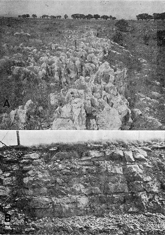
The Threemile Limestone Member of the Wreford Limestone is composed of limestone and chert having a total thickness of 17 to 19 feet. The chert is in the lower two-thirds of the member and is interbedded with thin beds of limestone; it appears in layers and as scattered nodules. The upper third of the Threemile is composed of limestone that in some places weathers to a deeply pitted surface (Pl. 8A). Small nodules of chert are scattered throughout this member. The contact of the Speiser Shale and the Threemile was mapped in the field and is shown on Plate 1 as the lower boundary of the area designated by the symbol Pc1.
Plate 8--A, Typical weathering of Threemile Limestone Member of Wreford Limestone. Cylindrical openings are clam borings enlarged by weathering. Photograph by D.E. Hattin. B, Outcrop of Florence Limestone Member of Barneston Limestone, at SW cor. sec. 28, T. 34 S., R. 5 E. The Florence here is about 16 feet thick.
The Havensville Shale Member overlies the Threemile, and in Cowley County it is composed principally of limestone and interbedded chert containing shale at the top and bottom of the member. Generally the shale is less than 1 foot thick, and more chert is present in the lower part of the limestone. Because the shale is thin and the slopes are heavily strewn with chert, the shale is not generally exposed except in fresh cuts. The shale in exposures is yellowish gray, silty, and calcareous. Total thickness of the Havensville Member is about 5 to 8 feet in Cowley County.
The Schroyer Limestone Member is the upper unit of the Wreford Limestone and is about 6 feet thick in Cowley County. This member is not as resistant to weathering as the Havensville Shale and the Threemile Limestone Members, and generally its outcrop is some distance back from the escarpment capped by the lower members. Chert occurs in layers and as nodules in the lower part of the unit. The upper part of the Schroyer is composed of limestone that is deeply pitted on the weathered surface.
Osagia-like algae, bryozoans, productids, crinoids, and echinoids are common in the fossiliferous zones in the Wreford, and the clams Aviculopinna and Allorisma are found in the pitted limestones, generally in the base of the borings.
The Wreford is an important aquifer in Cowley County, and many wells obtain water from it. Water seems to be transmitted through fractures in the chert. Yields, which range from a few gallons an hour to about 20 gpm, are not as large as from the Barneston Limestone, but they generally are adequate for domestic and stock use. Near the outcrop the rocks are almost drained, and the yields of wells may be very small. Water from the Wreford is generally hard but otherwise good. In some areas, however, the water may be polluted and in the deeper parts of the formation it may be mineralized.
Matfield Shale
The Matfield Shale, having a thickness ranging from about 55 to 60 feet, consists of varicolored shale interbedded with gray limestone. The Matfield is divided into the Wymore Shale Member, Kinney Limestone Member, and Blue Springs Shale Member. The upper boundary of the Matfield is not well marked, and the contact with the Florence Limestone Member of the Barneston Limestone is placed at the base of the lowest bed that contains chert. The uppermost few feet of the Matfield contain much shaly limestone and limy shale. The lower boundary of the Matfield is generally well marked and the contact is placed at the top of the uppermost massive bed in the Wreford Limestone.
The outcrop of the Matfield is generally narrow, occupying the steep slope beneath the escarpment made by the Barneston Limestone, but it is wider in areas where a thin remnant of the lower part of the Matfield overlies wide benches of the Wreford on long dip slopes. The Matfield is shown on Plate 1 as the upper part of the area designated by the symbol Pc1. A section measured in the center of sec. 3, T. 35 S., R. 5 E., above and below cuts in the railroad and the road, is given below.
| Barneston Limestone | Thickness (feet) |
||
|---|---|---|---|
| Florence Limestone Member (5.5 feet exposed) | |||
| Limestone and chert, thin interbedded layers | 4.0 | ||
| Limestone, massive, buff, weathers gray; contains some chert | 1.5 | ||
| Matfield Shale | |||
| Blue Springs Shale Member (34.2 feet) | |||
| Shale, gray, limy | 4.0 | ||
| Covered, mostly shale, some red shale | 25.0 | ||
| Shale, gray, limy; thin limestones near base | 5.2 | ||
| Kinney Limestone Member (14.3 feet) | |||
| Limestone, gray, weathers dark gray; has sandy rough appearance; contains fusulinids | 2.3 | ||
| Shale, gray | 1.0 | ||
| Limestone, upper part is yellow gray, slabby; lower 1.3 feet is massive | 2.3 | ||
| Shale, gray to yellow gray, limy | 6.2 | ||
| Limestone, gray, weathers gray brown; contains silicified fossils | 2.5 | ||
| Wymore Shale Member (12.5 feet) | |||
| Shale, gray to yellow buff, limy | 4.0 | ||
| Covered, mostly shale | 8.5 | ||
| Wreford Limestone | |||
| Schroyer Limestone Member (4 feet exposed) | |||
| Limestone, massive, white to buff; contains brachiopods | 2.5 | ||
| Shale, gray buff, limy | 0.5 | ||
| Limestone, massive, white | 1.0 | ||
The Wymore Shale is the lowermost member of the Matfield Shale and in Cowley County is composed of about 10 to 15 feet of maroon and gray shale. It is generally poorly exposed except in small draws and fresh road cuts.
The Kinney Limestone Member, overlying the Wymore, is composed of gray to buff limestone and interbedded gray limy shale and has a total thickness ranging from about 13 to 18 feet in the county. The fauna is composed principally of brachiopods, and in the southern part of the county these fossils are silicified. The uppermost limestone contains fusulinids and many small crinoid fragments. The fossils are partly silicified and upon weathering give a rough, sandy appearance to the outcrop.
The uppermost member of the Matfield is the Blue Springs Shale. This member is composed of red shale, gray limy shale, and limestone. The red shale is restricted to the lower part; much limestone and limy shale is found in the upper part. In northern Cowley County a limestone about 6 feet below the top of the Blue Springs is very persistent, but in southern Cowley County it was not observed. Brachiopods are common in the limy shales of the upper part of the Blue Springs. Fusulinids are present although not common.
The Matfield Shale is not an important aquifer in the county. In areas where the overlying Barneston Limestone does not yield an adequate supply, however, wells have been drilled into the underlying Kinney Limestone Member. Yields from the Kinney range from about 0.5 to 4 gpm. The water is hard but otherwise good.
Barneston Limestone
In northern Kansas the Barneston Limestone comprises the Florence Limestone Member, the Oketo Shale Member, and the Fort Riley Limestone Member. In Cowley County only the Florence Limestone and Fort Riley Limestone Members are present. The thickness of the Barneston in Cowley County ranges from about 80 feet in the northern part to about 65 feet in the southern part. The southward thinning of the formation is due principally to thinning of the Florence Limestone Member, which in northern Cowley County is about 35 feet thick and on the southern border is about 12 feet thick. The Fort Riley Limestone Member thickens somewhat to the south.
The Barneston Limestone occupies the largest area of any of the geologic units mapped in the county. Most of Range 5, all of Range 6, and parts of Ranges 4 and 7 are underlain by the Barneston. The base of the formation is placed at the base of the lowest limestone containing chert in the Florence Member and is mapped on Plate 1 as the lower limit of the area designated by the symbol Pc2. The upper limit of the Barneston is not easily identified. The contact between the Barneston and the overlying Doyle Shale is transitional, the flaggy limestone in the upper part of the Barneston grading into limy shale in the Doyle. This contact, although not sharp, is made evident in the field by a change in soil types formed on the two units and is shown on Plate 1 as a dashed line roughly dividing the area designated by the symbol Pc2. A section including the upper part of the Matfield Shale, the Florence Limestone Member of the Barneston, and all but about 10 feet of the Fort Riley Limestone Member was measured in road cuts from the creek northward to the top of the hill, beginning near the SW cor. sec. 28, T. 34 S., R. 5 E., and is described below.
| Barneston Limestone | Thickness (feet) |
||
|---|---|---|---|
| Fort Riley Limestone Member (56.6 feet) | |||
| Limestone, slabby to thin bedded, covered at this locality but exposed across valley to west | 10.0± | ||
| Limestone, thin bedded to slabby, white | 8.0 | ||
| Limestone, massive, gray to dark gray, surface pitted; contains crinoid fragments | 3.0 | ||
| Shale, limy, platy to flaggy | 1.0 | ||
| Limestone, massive to blocky, gray, weathers dark gray; contains many small crinoid fragments | 4.0 | ||
| Limestone, very thin bedded to platy, light gray; contains many small crinoids and a few productids | 6.3 | ||
| Limestone, dark gray to buff, in 2 beds 18 in. thick; contains echinoid spines | 3.0 | ||
| Limestone, massive to blocky, light gray, weathers dark gray | 1.5 | ||
| Limestone, three massive beds, white, weathers rusty brown; top bed 3 feet thick, middle bed 4.1 feet, and bottom bed 1.5 feet; contains sparse productids (Silverdale Quarry zone) | 8.6 | ||
| Limestone, slabby, light gray, weathers rusty brown | 2.5 | ||
| Limestone, massive to blocky, light gray, weathers dark gray | 2.0 | ||
| Limestone, massive, light gray, weathers rusty brown; contains a few productids and echinoid spines | 6.7 | ||
| Florence Limestone Member (16 feet) | |||
| Limestone and interbedded chert; a series of limestone beds 12 to 16 in. thick, interbedded with chert beds 3 to 6 in. thick; some chert nodules interspersed in the limestone. Chert increases in quantity downward to about two-thirds the distance through the member and then decreases in lower one-third. Echinoid spines, crinoids, and productids occur throughout the limestones; fusulinids in lower 6 or 7 feet. Base of Florence placed at lowest chert-bearing bed | 16.0 | ||
| Matfield Shale | |||
| Blue Springs Shale Member | |||
| Shale, gray, limy; contains Derbyia | 1.0 | ||
| Limestone, dense; contains productids, echinoid spines and plates, crinoids, and fusulinids | 1.2 | ||
| Shale, limy; contains many crushed brachiopods | 1.1 | ||
| Limestone, two layers separated by shale; contains Derbyia | 1.5 | ||
| Shale, brown to buff, blocky | 2.0 | ||
| Limestone, gray, buff | 0.5 | ||
| Shale, brown to buff and gray | 10.0 | ||
| Covered slope to creek; upper part mostly shale, lower part may contain some limestone | 20.0± | ||
Thick-bedded limestone interbedded with chert, having an aggregate thickness of 12 to 35 feet, constitutes the Florence Limestone Member. The limestone beds are relatively soft and have a massive to slabby appearance on the outcrop; they are light buff on fresh breaks but are light gray or white where weathered. The chert, in layers about 3 to 6 inches thick, is interbedded with limestone 12 to 16 inches thick. The chert is nodular, but the nodules are so closely spaced in some places that they seem to be a solid layer of chert (Pl. 8B). Isolated nodules of chert also are interspersed in the limestone. Freshly broken surfaces of the chert are blue gray but weathered surfaces are tan or dark rusty brown. The quantity of chert increases from the top toward the middle of the member, because of a thinning of the intervening beds of limestone, and decreases again toward the bottom. Echinoid spines and plates, crinoid fragments, and productids are common throughout the beds of limestone. Fusulinids are present in the lower half of the member, and the fossils increase in the basal beds. The Florence thins from about 35 feet in the northern part of the county to about 12 feet at the south line. Both the overlying Fort Riley Limestone Member and the underlying Matfield Shale thicken in the south, but it is not clear whether this has had any effect on the thinning of the Florence. The Blue Springs Shale Member of the Matfield Shale has a uniform thickness across the county, and the massive beds in the lower part of the Fort Riley seem to be continuous across the area. It would seem, therefore, that the thickness of the containing beds has little effect on the thickness of the Florence. The upper part of the Florence weathers more readily than the lower part and forms gentle slopes strewn with the residual chert. The lowermost part of the member is more resistant and forms exposures that can be traced over considerable distances.
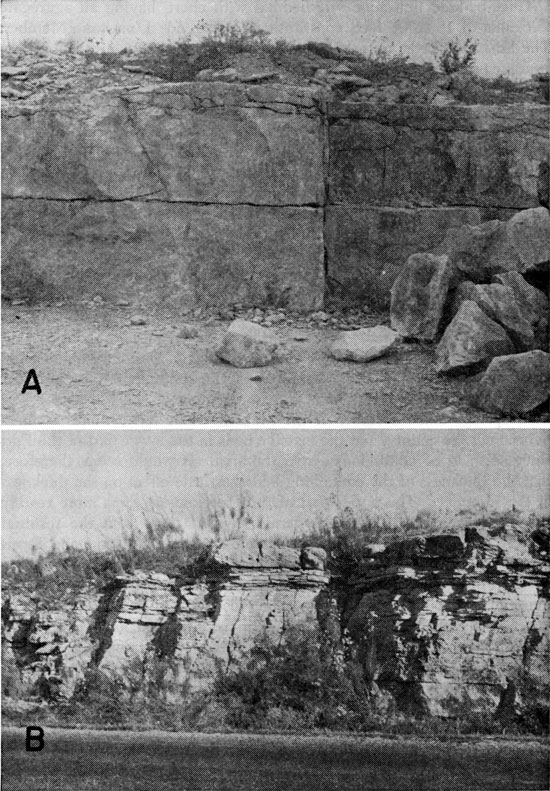
The Fort Riley Limestone Member is composed almost entirely of limestone, although the upper part contains a few thin shale zones. The lower 25 feet is composed principally of thick-bedded limestone, which is quarried extensively in the southern part of the county for building stone (Pl. 9A). The thickness of the Fort Riley ranges from about 45 feet in northern Cowley County to about 55 feet in the southern part. The contact of the Fort Riley and the Florence is placed at the top of the highest limestone bed that contains chert. In parts of southern Cowley County a thin stylolitic zone separates two beds of limestone, the upper of which contains no chert whereas the lower contains chert. This stylolitic zone may be indicative of a weak zone in the depositional sequence in which there has been solution and redeposition. Individual beds in the lower 25 feet of the Fort Riley can be traced over considerable distances and may be continuous across the entire county. Above the massive beds, thin-bedded to platy limestone predominates although a few massive beds and also some thin shale beds are present in this part of the member. In northern Cowley County and northward into Butler County the uppermost beds of the Fort Riley are thick-bedded limestone in which shallow sinks or depressions are common. These sinkholes are caused by solution and probably are related to the joint pattern in the area, as some of the depressions seem to line up with a particular joint when viewed on areal photographs. These sinkholes are especially well developed in the northern part of T. 30 S., R. 5 E. In central Cowley County, principally in the south half of T. 33 S., R. 6 E., there is a fairly thick bedded limestone having a cross-bedded appearance. This bed (Plate 9B) was observed at some outcrops in an area of about 10 square miles but was not observed elsewhere in the county. It lies a short distance below the upper third of the Fort Riley. In the southeastern part of T. 32 S., R. 5 E., and the northeastern part of T. 33 S., R. 5 E., shallow sinkholes have developed in a bed that may be just above the middle of the formation. These sinkholes also are related to the joint pattern in the area, but are not as well developed as those in the northern part of the county.
Plate 9--A, Fort Riley Limestone Member of the Barneston Limestone near SW cor. sec. 28, T. 34 S., R. 5 E. Beds shown are in Silverdale Quarry zone and are about 12 feet above the base of the member. B, Fort Riley Limestone Member near SE cor. sec. 19, T. 32 S., R. 6 E. Section shown is near middle of Fort Riley. Uppermost bed is cross bedded limestone.
The Barneston Limestone is the most important bedrock aquifer in the county. It is the most widely used aquifer, principally because of its wide areal extent. Yields of wells and springs in the Barneston depend on topography and structure and may range from only a few gallons an hour to more than 100. The largest yields are obtained in the synclinal area east of the Winfield Anticline and in an area in northern Cowley County where the Florence Limestone Member thickens. Water is transmitted through the formation through solution channels developed along bedding planes and joints in the Fort Riley and through joints and fractures in the chert beds in the Florence. The water is hard but unless locally contaminated is suitable for most uses. Wells more than 200 feet deep may yield water excessive in sulfates.
Doyle Shale
The steep slopes below the Winfield Limestone and the gently rolling slopes above the Barneston Limestone are formed by the Doyle Shale. The Doyle is composed principally of soft rocks that weather readily and, except the uppermost few feet of the formation, are poorly exposed in the county. The Doyle comprises three members, which in ascending order are the Holmesville Shale, Towanda Limestone, and Gage Shale. The thickness of the formation ranges from 75 to 90 feet, and changes considerably over relatively short distances, but generally an entire section of the formation is not exposed in the outcrops. A section measured by Bass (1929), near the middle of the east side of sec. 1, T. 35 S., R. 4 E., is described below.
| Winfield Limestone | Thickness (feet) |
||
|---|---|---|---|
| Cresswell Limestone Member (capping hill) | |||
| Doyle Shale | |||
| Gage Shale Member | |||
| Shale, limy, grayish tan, green in lower part, containing thin-bedded, shaly limestone; limestone increases upward; fossiliferous, upper 4 feet contains many limy concretions, which may be algal in origin | 11.0 | ||
| Shale, clayey, maroon, green in lower part | 27.0 | ||
| Shale, clayey, green, chiefly noncalcareous; a bed of limestone composed almost entirely of shells lies about 4 feet above base | 19.0 | ||
| Covered slope, probably mostly shale | 10.0 | ||
| Towanda Limestone Member | |||
| Limestone, light buff to light gray, cherty; contains abundant Pleurophorus subcostatus; locally forms a ledge | 2.0 | ||
| Holmesville Shale Member | |||
| Covered slope; shale and limy shale | 23.0 | ||
| Total thickness of Doyle Shale | 92.0 | ||
| Barneston Limestone | |||
The Holmesville Shale Member is composed of about 25 feet of limy, gray and buff shale and locally some red shale. The contact with the underlying Fort Riley Limestone Member of the Barneston is not sharp but is a gradational change from limestone to limy shale. Variation in thickness and composition of this gradational zone may account in part for the difference in thickness of the Doyle through the county.
A limestone approximately 2 feet thick that is about 25 to 30 feet above the base of the Doyle Shale is believed to be the Towanda Limestone Member of the Doyle Shale. This limestone is fairly persistent in southern Cowley County and is composed of light-buff or gray limestone, which in some areas contains scattered chert and is very resistant to weathering. North from about T. 34 S. this limestone does not crop out, but in some areas a slight bench is observed at about this position on the slope between the Winfield and Barneston Limestones. Pleurophorus subcostatus is common in most outcrops of the Towanda in southern Cowley County.
The uppermost member of the Doyle Shale is the Gage Shale. It ranges in thickness from about 55 to 65 feet in the county and is composed of gray-green shale in the lower part, red or maroon shale in the middle part, and gray-buff limy shale in the upper part. The lime content of the upper part of the Gage increases toward the top, and in places the member contains several thin-bedded shaly limestones. The upper part of the Gage is very fossiliferous, Derbyia, Allorisma, Deltopecten and Pleurophorus being common. In nearly every exposure observed, the uppermost few feet of the Gage contain small concretions, as much as half an inch in diameter but more commonly a fourth of an inch, which may be of algal origin. This concretionary zone marks the contact with the overlying Winfield Limestone. The logs of some wells north of T. 33 S. indicate the presence of a limestone near the middle or in the lower part of the Gage. This limestone is not persistent and generally is not exposed, but may be the limestone at about the same stratigraphic position that crops out in a small area adjacent to Rock Creek near the county line in T. 30 S., R. 4 E. That limestone is thin bedded to platy and somewhat nodular and is buff on fresh breaks but light gray where weathered.
The Doyle Shale is not an important aquifer in the county but it yields some water to wells from the upper limy zone and from the Towanda Limestone Member. Yields of wells from the upper zone are small, but yields from the Towanda are generally larger, ranging from a few gallons an hour to as much as 50 gpm. In northern Kansas the Towanda is a platy, impure limestone containing many calcite veinlets and it seems to be very permeable. A similar zone may be present in the Towanda in parts of Cowley County where the larger yields of water are obtained.
Winfield Limestone
The Winfield Limestone is the uppermost prominent scarp-forming rock unit in Cowley County. In northern and central Kansas this formation is composed of the Stovall Limestone Member at the base, the Grant Shale Member, and the Cresswell Limestone Member at the top. In Cowley County only the Cresswell Member is recognized. The Winfield Limestone is shown on Plate 1 as the lower part of the area designated by the symbol Pc3. The Cresswell Limestone Member in Cowley County ranges in thickness from about 20 feet to as much as 30 feet. It may be divided into two units, a lower massive unit 10 to 12 feet thick, which forms the conspicuous outcrop, and an upper unit composed of thin-bedded to shaly limestone ranging in thickness from 15 to 20 feet. This upper unit, formerly named the Luta Limestone, is well defined at the base, where the rock changes from thin-bedded limestone to the massive, scarp-forming limestone below. The upper boundary is not well defined, as the rock grades into the overlying Odell Shale. This upper unit was formerly classed as a part of the shale unit overlying the Winfield Limestone, and for mapping, such a classification would be desirable.
Plate 10--A, Cresswell Limestone Member of Winfield Limestone along highway west of Walnut River in NW sec. 29, T. 32 S., R. 4 E. Upper and lower resistant beds are separated by more easily weathered bed. B, Cresswell Limestone Member in SE NE sec. 20, T. 34 S., R. 4 E., near Arkansas City Country Club, showing massive nature of Cresswell in southern Cowley County.
The lower unit of the Cresswell Limestone Member is composed of massive, gray-weathering, buff limestone, which in the northern and central parts of the county may be divided, on its weathering characteristics, into three beds. The upper bed, 3 or 4 feet thick, has a rough, sandpaper appearance and the surface is pitted. The rough appearance is caused by many fragments of fossils, partly silicified, which are more resistant to weathering than the surrounding matrix. The middle bed, which ranges in thickness from only a few inches to about 1 1/2 feet, is much less resistant to weathering than the beds above and below and makes a deep indentation in the face of weathered exposures. The lower bed is a massive limestone similar to the top bed and is about 6 feet thick. This bed seems to be more resistant to weathering than the upper bed (Pl. 10A). Southward from the southern part of T. 34 S. the deeply weathered bed is absent, and exposures along the outcrop are composed of one massive ledge 10 to 12 feet thick (Pl. 10B). The most common fossils in the lower, massive part of the Cresswell are Archaeocidaris spines and plates, and the brachiopods Derbyia, Composita, and productids. The upper thin-bedded unit (formerly called Luta) is very fossiliferous. Bryozoans, Composita, Derbyia, and Chonetes are the most common fossils. Parts of a small trilobite also are common, and rare specimens of a larger, coiled trilobite, as much as three-fourths of an inch across, were found. Large specimens (as much as 6 inches in diameter) of a cephalopod are found in these beds, but they are rare. A section through the Nolans and Winfield Limestones along the road on "140-foot hill" just south of Arkansas River in the SE SW SE sec. 5, T. 35 S., R. 4 E., is described below.
| Thickness (feet) |
|||
|---|---|---|---|
| Soil cover | 3± | ||
| Nolans Limestone (10.9 feet) | |||
| Herington Limestone Member | |||
| Limestone, massive, white; contains small chert nodules; nonfossiliferous | 5.3 | ||
| Limestone, white, thin bedded to slabby; contains no chert; small geodes present in lower part; contains Archaeocidaris spines | 5.6 | ||
| Paddock Shale Member (7.3 feet) | |||
| Shale, platy, gray to blue gray; contains crinoids, Deltopecten, and many fragments of other fossils | 7.3 | ||
| Krider Limestone Member (9.8 feet) | |||
| Limestone, dark blue gray, weathers buff, hard | 1.6 | ||
| Shale, gray, platy | 1.0 | ||
| Limestone, shaly, very fossiliferous; contains small crinoids, Composita, and biscuit algae | 2.0 | ||
| Limestone, blue gray; contains crinoids and bryozoans | 1.0 | ||
| Limestone, very fossiliferous; contains crinoids, Myalina, Composita, and many minute gastropods adhering to Composita shells; contains biscuit algae in lower 1 foot | 3.1 | ||
| Limestone, gray, hard; contains fossil fragments | 1.1 | ||
| Odell Shale (38.1 feet) | |||
| Shale, gray, platy | 4.0 | ||
| Shale, gray, clayey; contains many secondary calcareous fillings in joints and bedding planes (boxwork appearance) | 5.2 | ||
| Shale, gray to very dark gray | 2.0 | ||
| Shale, gray, clayey; contains secondary calcite in joints and bedding planes | 6.1 | ||
| Limestone, shaly; has breccia appearance owing to filling of joints and seams by calcite | 2.2 | ||
| Limestone, vuggy; contains concretions as much as 2 inches in diameter 1.1 | |||
| Shale, gray, clayey; contains secondary calcite in joints and seams | 6.0 | ||
| Limestone, white, thin bedded; contains a few concretions | 2.5 | ||
| Shale, limy, platy | 9.0 | ||
| Winfield Limestone (30.5 feet) | |||
| Cresswell Limestone Member | |||
| Limestone, thin bedded to platy, white | 9.5 | ||
| Limestone, same as above but contains Archaeocidaris spines and crinoid fragments | 1.5 | ||
| Limestone, thin bedded; contains Composita, Derbyia, crinoids, Archaeocidaris spines, and small trilobites | 1.2 | ||
| Limestone, thin bedded to shaly, nonfossiliferous | 6.0 | ||
| Limestone, white to gray, one massive bed; has rough appearance; contains productids and a few Archaeocidaris plates | 12.3 | ||
| Doyle Shale (8.0 feet exposed) | |||
| Gage Shale Member | |||
| Shale, gray to tan gray, poorly exposed, limy | 8.0+ | ||
The Winfield Limestone yields water to wells in northwest Cowley County. Yields of the wells visited were not large, although they were generally adequate for stock and domestic supplies. West of Winfield, in sec. 25, T. 32 S., R. 3 E., test holes indicate that the Winfield Limestone is cavernous, and probably wells 32-3-24bdc and 32-3-25bdc obtain part of their water from it. East of Walnut River, the Winfield caps isolated hills or buttes and is almost drained, although a few shallow wells probably obtain some water from it. In southern Cowley County little if any water is obtained from the formation.
Odell Shale
The rocks between the top of the Winfield Limestone and the base of the Nolans Limestone are included in the Odell Shale. The Odell is composed principally of calcareous shale, but the material ranges from clayey shale to impure shaly limestone. Gray is the dominant color. A thin very dark gray or dark-blue-gray zone about 10 feet below the top of the formation seems to be persistent in the southern part of the county. Small calcareous geodes are present in a zone composed of very limy shale and impure limestones just below the middle of the formation. The Odell occupies the greater part of a gently graded slope between the scarp-forming part of the Winfield Limestone and the Herington Limestone Member of the Nolans Limestone. The outcrop belt is relatively narrow, and lies principally west of Walnut River. It becomes even narrower in southern Cowley County, where the Nolans Limestone is more resistant to weathering and forms a steeper scarp than in the north. The formation is nonfossiliferous. A description of a measured section of the Odell accompanies that of the Winfield.
The Odell Shale is not known to yield water to wells in Cowley County.
Nolans Limestone
The Nolans Limestone is the uppermost formation of the Chase Group. This formation, having a total thickness in Cowley County of about 40 feet, is composed of three members: in ascending order, the Krider Limestone, Paddock Shale, and Herington Limestone. The lower part of the Herington is the most resistant part of the formation and forms the only conspicuous bench or scarp in the outcrop area. Even this part of the Herington weathers in most areas, however, and over much of the outcrop area produces no apparent break in the slope rising from the Winfield Limestone. The Nolans forms the upper part of the area shown on Plate 1 by the symbol Pc3. A section from the resistant part of the Herington Limestone Member down through the Krider Limestone Member has been described in connection with the Winfield.
The Krider Limestone Member is composed of an upper, thin, blue-gray limestone that weathers buff, and a lower limestone, separated by about 3 feet of gray shale. The Krider ranges in thickness from about 4 to 9 feet; its maximum thickness is attained in the southern part of the county. The upper limestone is hard and brittle and is seemingly nonfossiliferous; the lower limestone consists of alternating hard and soft beds and some shaly limestone. The shale separating the two limestone beds is limy in the lower part and contains many fossils, the most common being crinoids, Composita, and biscuit algae. The lower limestone is also very fossiliferous; almost the entire middle part of the bed is composed of the brachiopod Composita and biscuit algae. The Composita shells in this bed are covered by specimens of a very small gastropod ranging from 1/16 to 1/8 inch across.
The Paddock Shale Member is composed of about 7 feet of gray, calcareous shale, the lower part being very calcareous. Fragments of crinoids and of many other fossils are in the lower part.
The Herington Limestone Member is composed of a lower limestone unit, about 10 feet thick, and an upper dolomitic unit. The contact between them is not sharp but gradational. The total thickness of the Herington may be as much as 30 feet, but the upper part weathers readily, and good exposures are rare; where observed, this part of the Herington has a sandy or granular appearance, and contains calcite geodes in the lower part. The limestone unit in the lower part of the Herington is the ledge-forming part, and it varies considerably in lithology and appearance across the outcrop area in the county. In the south, the Herington is composed of a fairly pure massive limestone containing chert nodules in the upper part and geodes in the lower part. In the north-central part of the outcrop in an exposure near the center of the south line of sec. 34, T. 30 S., R. 3 E., the lower part of the Herington is massive and has a blocky rectangular structure. In the NE sec. 4, T. 30 S., R. 3 E., an exposure in a creek bed on the county line shows the same blocky limestone, but here the upper part contains chert nodules and the lower part contains geodes.
The Nolans Limestone yields water to wells in Cowley County, principally from the Herington Limestone Member. The quantity ranges widely, however. In southern Cowley County little if any water is obtained from the Nolans Limestone. In northwestern Cowley County, principally in T. 30 S., R. 3 E., domestic supplies are obtained from the Nolans. The city of Udall formerly obtained its municipal supply from this formation through large-diameter wells near the city, but it abandoned the wells because of insufficient supply and poor quality of the water. West of Winfield, in sec. 24 and 25, T. 32 S., R. 3 E., the Herington is cavernous, probably from solution of gypsum, and wells in this area yield as much as 1,000 gpm. The city of Winfield uses water from this area as a supplementary supply to blend with water from the Arkansas River valley. Water from the cavernous limestone is low in chlorides but almost always high in sulfates. South from T. 32 S. the cavernous limestone thins or is absent, and it is difficult to obtain an adequate supply of water for domestic and stock use.
Permian System--Middle Permian Series
Sumner Group
In Kansas the Sumner Group comprises the Stone Corral Dolomite, the Ninnescah Shale, and the Wellington Formation and has a total thickness of about 1,000 feet. Gray silty shale is predominant, but there are also red and green shale, dolomite, limestone, anhydrite, gypsum, and salt. In Cowley County only the lower part of the Wellington Formation is present.
Wellington Formation
Although in other parts of Kansas the total thickness of the Wellington may be as much as 700 feet, only about 80 feet of rock, composed principally of soft gray shale, constitutes the Wellington Formation in Cowley County. This portion of the Wellington contains a few thin limestone beds, which are exposed only in small areas and, except for one gypsiferous limestone about 50 feet above the Herington Limestone Member, have not been correlated elsewhere. The gypsiferous limestone is exposed in a few small areas in the county but is reported in many drill holes, and it may correlate with the Hollenberg Limestone. The Wellington is composed mainly of soft materials that weather readily, hence good exposures of the formation are rare. Generally, the formation occupies the gentle soil-covered slope rising above the Herington Limestone. In some places the Wellington is overlain by silts of Pleistocene age, and as the soil types and topographic expression of the two units are similar, the contact of the two is difficult to define. The Wellington Formation is shown on Plate 1 by the symbol Pw.
The Wellington Formation yields water to a few wells in the upland area of western Cowley County. The water is obtained principally from the thin limestones or limy zones within the formation. Yields of the wells are generally inadequate for domestic needs, and the water is generally of poor quality. The city of Geuda Springs formerly obtained water from a well dug in the Wellington, but the supply was inadequate, and the well was abandoned.
Quaternary System--Pleistocene Series
Quaternary deposits in Kansas are of continental origin and are assigned to the Pleistocene Series. They are composed of silt, clay, sand and gravel, and small amounts of volcanic ash. The Pleistocene Epoch as defined by the State Geological Survey of Kansas is the last of the major divisions of geologic time and has been called the "Ice Age," owing to the presence of continental glaciers in North America and elsewhere. The Pleistocene Series in Kansas has been divided into the Nebraskan, Kansan, Illinoisan, and Wisconsinan glacial stages, and the Aftonian, Yarmouthian, and Sangamonian interglacial stages. Events in each of the periods of continental glaciation followed a cyclic repetition. Each cycle consists of a glacial and an interglacial interval or stage. The cycle in a marginal belt around a glaciated area is characterized by a period of downcutting in the valleys and some local deposition of sediment, followed by a period of deposition of coarse material beyond the glacial limit, deposition of progressively finer material as the glacier retreated, and finally the development of a soil profile over a large area where surface conditions were relatively stable.
During the Nebraskan and Kansan times, continental glaciers covered northeastern Kansas with glacial drift. During the Illinoisan and Wisconsinan advances the continental glaciers did not reach Kansas, but the climatic changes accompanying their approach had a direct effect on the Pleistocene deposits over Kansas.
Cowley County is about 175 miles beyond the southernmost advance of any of the ice sheets and did not receive outwash material from the glaciated area. The principal effect of the glaciers in Cowley County, therefore, was climatic. The trunk stream draining Cowley County in Early Pleistocene time headed in western Kansas and had no direct connection with the Rocky Mountains until late Kansan time. During Illinoisan time the present drainage pattern of most of the large streams of the state was established. Arkansas River established its present course during Illinoisan time, and drainage from the mountains was carried through south-central Kansas, including Cowley County. Throughout Pleistocene time the major streams draining central and eastern Cowley County were cutting their channels near their present courses. Sediments deposited by these streams were composed of locally derived material, chiefly pebbles of limestone and chert, whereas sediments deposited by Arkansas River were principally arkosic and were derived mainly from the Ogallala Formation (Pliocene) in the western part of the state.
The State Geological Survey divides the Pleistocene Series into a Lower Pleistocene Subseries and an Upper Pleistocene Subseries. The Nebraskan, Aftonian, Kansan, and Yarmouthian Stages are included in the Lower Pleistocene Subseries, and the Illinoisan, Sangamonian, Wisconsinan, and Recent Stages are included in the Upper Pleistocene Subseries.
Lower Pleistocene Subseries
Deposits of Nebraskan and Aftonian age have not been recognized in Cowley County. Deposits of this age probably were laid down in western Cowley County by an ancestral Arkansas River but were later removed by erosion. High-level chert gravel observed in a few small areas in north-central and eastern Cowley County may be of this age. These deposits are very thin and are not shown on Plate 1.
Kansan and Yarmouthian Stages
Grand Island and Sappa Formations--Some deposits in western and southwestern Cowley County that are associated with the Arkansas River drainage compose the Grand Island and Sappa Formations of Kansan and Yarmouthian age. These deposits, which are derived from the west, consist principally of silt, clay, and arkosic sand and gravel. Deposits adjacent to Walnut River and Grouse Creek, consisting of chert and limestone gravel and small amounts of sand, silt, and clay, also are included in the Grand Island and Sappa Formations. These deposits are of local origin and indicate drainage during Kansan and Yarmouthian time closely paralleling present drainage.
The Grand Island and Sappa deposits associated with the Arkansas River drainage are as much as 40 feet thick and are overlain almost everywhere by eolian silts ranging in thickness from a few feet to as much as 30 feet; they are shown on Plate 1 by the symbol Qs/Qka. Coarse material in the basal part, becoming progressively finer upward through sandy silt to a compact silt in the upper part, is recorded in logs of test holes penetrating these deposits. The coarse basal material consisting of sand and gravel is not present everywhere, and logs may indicate only the finer material commonly found in the upper part of the formation.
The surface of the area underlain by the Grand Island and Sappa Formations between Walnut and Arkansas Rivers is topographically higher than adjacent deposits of Illinoisan and Sangamonian age, and bedrock incision is not so deep under the deposits of Kansan and Yarmouthian age. Locally a bedrock bench is present beneath Grand Island and Sappa Formations adjacent to the Crete and Loveland Formations, of Illinoisan and Sangamonian age (Pl. 4). The former probably were much more extensive originally but large parts have been removed. In T. 32 S. the Grand Island and Sappa Formations occupy a narrow belt just west of the divide between Walnut and Arkansas Rivers and probably were continuous westward for about 10 miles, as similar deposits are present in Sumner County. Southward, in T. 34 S., R. 4 E., these deposits may not have been laid down over the high upland area north of Walnut River; remnants in sec. 36, T. 33 S., R. 4 E., lie at a lower altitude than either the Winfield Limestone or the upland area to the south and west. Between extreme western Cowley County and a point near the southeastern comer of T. 33 S., R. 4 E., these deposits seem to be entirely arkosic. In the area just east of Walnut River east of Arkansas City, deposits of Kansan and Yarmouthian age occupy a high upland position. Here the deposits, although chiefly arkosic, contain a small percentage of chert gravel, and southward into Oklahoma in deposits of equivalent age the ratio of locally derived material to arkosic material increases.
Deposits of chert gravel occupy a high terrace position along the valley walls of Walnut River and Grouse Creek and are present locally along other streams draining the area of Permian exposures in north-central and eastern Cowley County. These deposits, which are probably Kansan and Yarmouthian in age, are generally thin and are not continuous. A projection of the profile through these deposits seems to merge with the Grand Island and Sappa Formations associated with the Arkansas River drainage. The chert gravel deposits of Kansan and Yarmouthian age are shown on Plate 1 by the symbol Qs/Qkc. Only the thicker and more extensive deposits were mapped, but in many areas thin deposits of chert gravel were observed at about the same level as those mapped.
The Grand Island and Sappa Formations yield moderate amounts of water to wells in Cowley County. Domestic and stock supplies are obtained from these formations over much of the area of outcrop. In some areas these deposits are principally silt, and the yields of wells are very low, and in other areas thin deposits associated with the Arkansas River drainage are above the water table and yield no water to wells. The Grand Island and Sappa Formations just east of Walnut River east of Arkansas City are composed of coarse gravel in the lower part, and large yields of water can be obtained, but these gravels are very limited in areal extent and their water supply depends entirely on local recharge. In part of the area southwest of Arkansas River west of Arkansas City, the Grand Island and Sappa Formations contain gravels in the basal part that are thick enough to yield relatively large quantities of water, but these gravels are present only in the deepest part of the buried channel underlying this area (Pl. 3A).
Chert gravel deposits of Kansan and Yarmouthian age are above the water table except during periods of very heavy precipitation.
Water from the Kansan deposits is somewhat hard but is generally usable.
Upper Pleistocene Subseries
The Upper Pleistocene Subseries includes all units of the Pleistocene Series younger than Yarmouthian. Deposits representing all major subdivisions of the Upper Pleistocene are present in Cowley County.
Illinoisan and Sangamonian Stages
Crete and Loveland Formations--Climatic changes immediately preceding and during early Illinoisan time reactivated Arkansas River; much of the Grand Island and Sappa Formations was removed, and the channel was cut below the base of these deposits (Pl. 4). Arkansas River drainage during this time roughly paralleled the present Arkansas River in west-central Cowley County and then flowed eastward to a point near the southeast corner of T. 33 S., R. 4 E., where the stream was joined by Walnut River. From this junction the stream followed the present Walnut River to a point near its present junction with Arkansas River. That part of the present Arkansas River between Arkansas City and a point near the southwest corner of T. 33 S., R. 3 E., does not seem to have been a part of the through-flowing stream but, rather, a tributary that joined the old Arkansas River near Arkansas City. This part of the Arkansas River valley is narrow, and deposits older than Wisconsinan age were not observed.
Chert gravel deposits in terrace position to other major streams, which drain north-central and eastern Cowley County, indicate that these streams were deepening their channels during this period. These deposits were observed in only a few localities, and in only one area were they thick enough to map. These deposits are shown on Plate 1 by the symbol Qic. Chert gravel about 10 feet thick is present near the middle of the north line of sec. 4, T. 33 S., R. 4 E., in an intermediate position about 80 feet below the projected level of Kansan deposits and about 30 feet above the level of Wisconsinan terrace deposits.
Major drainage changes or adjustments affected the Arkansas River drainage during Illinoisan time. "Wilson Valley," which drained Saline River into Smoky Hill River, and "McPherson Channel," which drained Smoky Hill River into Arkansas River, were abandoned, and a large part of the former drainage into Arkansas River was diverted into Kansas River. These diversions were upstream from Cowley County and presumably affected the lithologic character of the Crete and Loveland Formations in the county. In the area related to the Arkansas River drainage, the Illinoisan and Sangamonian deposits, shown on Plate 1 by the symbol Qia, are composed of a basal arkosic sand and gravel overlain by sandy silt, which is overlain by a reddish silt. The basal gravels in this part of the formation are generally relatively thin, and the predominance of silts may reflect the loss of drainage through the diversions mentioned above. The upper surface of these deposits lies about 35 feet above the surface of the younger Wisconsinan terrace deposits, and a pronounced terrace scarp marks the boundary between them (Pl. 11A). Southward from a point near the southeast comer of T. 33 S., R. 4 E., where the old Arkansas River in Illinoisan time was joined by Walnut River, both arkosic and chert gravel are present in these deposits, indicating a western and an eastern source of the materials. The Crete and Loveland Formations in western Cowley County range in thickness from about 40 to 55 feet. Southward from the junction of Walnut and Arkansas Rivers, resistant Permian limestone underlies the surface; incision by the stream during Illinoisan time was not great, and the deposits are thin.
Plate 11--A, Illinoisan terrace scarp east of Arkansas River in NE sec. 20, T. 32 S., R. 3 E. Wisconsinan terrace level in foreground. B, Wisconsinan terrace cut through by Walnut River in NE SE sec. 23, T. 33 S., R. 4 E.
The Crete and Loveland Formations are important sources of ground water in western Cowley County. In the area designated by the symbol Qia on Plate 1, yields of most wells range from about 50 to 200 gpm, and those of some wells are as much as 300 gpm. Many domestic and stock wells and four irrigation wells obtain water from these deposits. Formerly the Army air base midway between Arkansas City and Winfield obtained water from wells drilled in these deposits. Hydraulic connection with adjacent aquifers is poor or absent, and recharge is entirely from precipitation on the area. Southward from the point where Walnut River joined Arkansas River during Illinoisan time, the Crete and Loveland Formations are almost drained, and water is obtained from them only locally. Chert gravel deposits associated with Walnut River and Grouse Creek are above the water table.
The water from these deposits is hard (carbonate), but chloride concentration is low except in parts of sec. 26, 27, and 34, T. 32 S., R. 3 E., where some domestic supplies and one irrigation well have been polluted. The source of the chloride in this area is a small abandoned oil field near the northeast corner of sec. 26, T. 32 S., R. 3 E., and the northwest corner of sec. 27, T. 32 S., R. 3 E.
Wisconsinan Stage
Terrace deposits--Climatic changes at the beginning of the Wisconsinan Stage rejuvenated Arkansas River and caused it to remove much of the material deposited in Illinoisan and Sangamonian time. The new channel was incised below the level of the base of the Crete and Loveland Formations and was partly filled with silt, clay, sand, and gravel. The surface of these deposits lies a few feet above the Recent alluvium in a terrace position to the present Arkansas River. The surface of this terrace has about the same altitude as the base of the Crete and Loveland Formations that border the terrace on the east (Pl. 4). The Wisconsinan terrace deposits are composed of arkosic sand and gravel in the basal part and silt and clay in the upper part. The thickness ranges from about 40 feet to about 55 feet in the Arkansas River valley. These deposits are shown on Plate 1 by the symbol Qtwa.
Terrace deposits equivalent in age to the Wisconsinan terrace deposits in the Arkansas River valley are present in all the major stream valleys that drain northern and eastern Cowley County. Generally these deposits are much thinner than those in the Arkansas River valley and are composed of lithologically different materials from different sources. These terrace deposits are composed of limestone, chert gravel, and sand, intermixed with different amounts of silt and clay. The deposits contain beds of silt, beds of gravel containing almost no silt, and much gravel interspersed with silt. These terrace deposits are shown on Plate 1 by the symbol Qtwc. Plate 11B shows Wisconsinan terrace deposits that have been cut by Walnut River.
The Wisconsinan terrace deposits are the most important source of ground water in the county. In the Arkansas River valley, yields as great as 1,000 gpm are common. Arkansas City, Winfield, and Oxford obtain their supplies from these deposits. Many domestic and stock supplies and several irrigation wells also utilize this aquifer.
The quality of the water from this aquifer is not uniform throughout the area. In much of the area the concentrations of mineral constituents in the water exceed recommended standards of the Public Health Service but are within the range of standards for usable water. Although large quantities of water are available from these deposits, irrigation is not practiced extensively in the county, owing in part to the quality of the water. Oil has been produced in this area for about 35 years, and for many years brine produced from oil wells recharged the aquifer from "evaporation" ponds. The salt water entering the aquifer, although diluted to some extent, settles to the bottom of the aquifer as a salt-water body or unit. This salt-water body then moves downgradient at a very slow rate, although its rate of movement may be increased by the pumping of nearby wells or by the pumping operations in active gravel pits. The salt content of the ground water in parts of the area is very large, chloride concentration ranging to about 60,000 ppm. The cities of Winfield and Oxford and many domestic users have bad to abandon wells because the water became salty. In areas of no pollution, the water is hard but is suitable for most uses.
Water containing chloride is discharged from Permian rocks into the alluvium and Wisconsinan terrace deposits in the vicinity of Belle Plaine in Sumner County. As this water moves downgradient, it is diluted with water of better quality and, except for the local area of discharge near Belle Plaine, is of usable quality. Near Geuda Springs, salt water is discharged from the Permian rocks as springs and by seepage into the alluvium and Wisconsinan terrace deposits. Local concentrations of chloride are probably from this source.
Some of the water in the Wisconsinan terrace deposits bordering the streams that drain northern and eastern Cowley County also has been polluted. These deposits are thin and contain much silt, but large yields can be obtained from wells locally. The Dexter water supply is obtained from these deposits.
The chloride concentration in the water from Walnut River terrace deposits is excessive in some areas. In past years the surface water has been polluted, and probably some of this water has entered the aquifer from the river, but most of the pollution in the aquifer has resulted from seepage from disposal ponds, which were formerly permitted in the valley. The partial analyses of samples of water from these deposits, given in Table 7, indicate that the water contains less chloride than many of the samples collected from the Arkansas River valley.
Eolian silt deposits--Wind-deposited silts overlie older deposits in much of western Cowley County. Deposits of Kansan and Yarmouthian age are overlain nearly everywhere by these silts, which may have a thickness of as much as 30 feet. These silts occupy a high upland position and are of similar origin, and they could not be differentiated from the older deposits by study of logs of drill holes. The uppermost silts are almost certainly Late Pleistocene in age and in this report are assumed to be Wisconsinan. They are shown on Plate 1 by the symbol Qs. Silts of eolian origin are present in surface exposures and drill holes in the south valley wall of Arkansas River. They extend well down into the valley and seem to be continuous with the silts overlying the deposits of Kansan and Yarmouthian age. Late Pleistocene origin is indicated by the low position of the silts in the valley. Silts that seem to be of eolian origin are present also in part of the area underlain by deposits of Illinoisan and Sangamonian age. These silts were observed in some drill cuttings. They are relatively thin and on the geologic map they are not distinguished from the underlying deposits. The eolian silts probably were deposited over a much larger area but have been altered by weathering or have been removed.
The eolian silts are above the water table in much of the area, hence yield no water to wells, but they have a considerable effect on recharge of the underlying deposits.
Recent Stage
Alluvium--Recent alluvium occupies the valleys of all the major streams in Cowley County, but all streams except Arkansas River are deepening their channels over most of their courses and, consequently, alluvium is present only in the narrow, active channels of the streams. The deposits are thin and are not mapped separately on Plate 1. They are composed of silt, sand, chert, and limestone gravel, but because of their small areal extent they are not important sources of ground water.
In the Arkansas River valley the Recent alluvium adjacent to the stream is as much as a mile wide. Lithologically these deposits are similar to the Wisconsinan terrace deposits, and it is difficult to differentiate the two by use of subsurface data. The alluvium in the Arkansas River valley was distinguished from the terrace deposits on the basis of surface position and topographic expression. The surface of the alluvium is a few feet below the terrace surface, and in some places a terrace scarp of a few feet separates the two deposits. The surface of the alluvium is rough and hummocky, and old meander scars are common, whereas the surface of the Wisconsinan terrace is relatively flat and exhibits a more mature stage of development. The Recent alluvium, which is as much as 50 feet thick in the Arkansas River valley, is shown on Plate 1 by the symbol Qal.
Ground-water conditions in the alluvium are very similar to those in the terrace deposits. Much ground water is available, but much of it is unsuitable for use. The alluvium has received pollution from oil-field brines and by water of poor quality entering the aquifer from the river; most of the time, however, the stream gains water from the aquifer. The salt content of the water in Arkansas River increases considerably at its junction with Salt Creek in the NE sec. 7, T. 33 S., R. 3 E. Salt Creek heads in Permian shales in eastern Sumner County and is fed by mineral springs.
Prev Page--Subsurface rocks || Next Page--Structure
Kansas Geological Survey, Geology
Placed on web May 21, 2009; originally published August 1962.
Comments to webadmin@kgs.ku.edu
The URL for this page is http://www.kgs.ku.edu/General/Geology/Cowley/05_outc.html