![]()
Prev Page--Introduction || Next Page--Subsurface rocks
Geography
Physiography and Topography
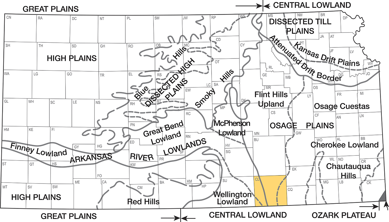
Cowley County is in the Osage Plains and the Arkansas River Lowland sections of the Central Lowland physiographic province (Fig 3). Cowley County includes parts of the Flint Hills Upland and Osage Cuestas divisions of the Osage Plains section and part of the Great Bend and Wellington Lowlands divisions of the Arkansas River Lowland section (Schoewe, 1949).
Figure 3--Physiographic map of Kansas (after Schoewe, 1949).
The surface features that make up the physiographic divisions in Cowley County are directly related to the types of outcropping rocks. With the exception of the west tier of townships, almost the entire county is underlain by alternating layers of limestone and shale, which crop out in belts extending across the county in a nearly north-south direction. The limestone layers, being more resistant to weathering, form benches or escarpments, and the softer shale layers, weathering more readily, form steep eastward-facing slopes between the limestone ledges. The part of the county lying west of the outcrop of the Herington Limestone Member of the Nolans Limestone is almost covered by terrace deposits of Pleistocene age, which form a smooth, gently-sloping surface.
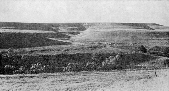
The principal physiographic division in Cowley County is the Flint Hills Upland division. In the southeastern part of the county the east boundary of this division is marked by the thick, chert-bearing Foraker Limestone. In this area the Foraker forms a pronounced escarpment, and succeeding younger limestones form widely spaced benches on the upland surface to the west. In northeastern Cowley County the east boundary of the Flint Hills Upland division is formed by the escarpment of the Wreford Limestone. The underlying limestones down to the base of the Foraker form benches, but they are not so widely spaced laterally as those in the southern part of the outcrop (Pl. 7). Below the base of the Foraker Limestone the thin limestone beds in the Admire and Wabaunsee Groups form only low benches in the Osage Cuesta division. Relief along the east border of the Flint Hills Upland may be as much as 300 feet, but in the area adjacent to the Foraker Limestone it is commonly 150 feet. Westward from the eastern edge of the Flint Hills Upland division are a series of step-like escarpments or benches formed by the younger limestones. The surface of each bench slopes gently westward at a rate about equal to the regional dip of the strata. The underlying shale weathers to form steep slopes adjacent to the escarpment of the overlying, limestone. The relief of these benches may be as much as 100 feet locally. The west border of the Flint Hills Upland division is marked by the bench formed by the Herington Limestone Member of the Nolans Limestone. This bench is much more pronounced in the southern part of the outcrop area than in the north.
Plate 7--Typical Flint Hills topography at Elk-Cowley county line in sec. 4, T. 31 S., T. 8 E. Bench in foreground formed by Grenola Limestone, middle bench formed by Beattie Limestone, and nearby hill capped by Crouse Limestoe. In far distance Wreford Limestone caps upland surface.
The relatively flat area of low relief west of the Herington outcrop is included in the Great Bend Lowlands physiographic division. This area is underlain by the thick Wellington Formation, which is almost covered by terrace deposits of Pleistocene age associated with the ancestral Arkansas River.
A small area in extreme southwestern Cowley County lies in the Wellington Lowlands physiographic division. This area lies south and west of Arkansas River and at a higher altitude than the area included in the Great Bend Lowlands. This area also is underlain by the Wellington Formation, which is almost covered by Pleistocene deposits older than those in the Great Bend Lowlands. Topographic relief in the Wellington Lowlands is greater than in the Great Bend Lowlands.
The surface altitude of Cowley County ranges from about 900 feet in the valley of Rock Creek in the southeastern part of the county to about 1,500 feet in the northeastern part. In most of the county, the surface altitude ranges from 1,150 to 1,350 feet above sea level.
Drainage
Arkansas and Walnut Rivers are the principal streams in the county. Walnut River joins Arkansas River from the east at Arkansas City in southern Cowley County. The Walnut flows almost due south through the county. Its eastward-flowing tributaries are short and drain relatively small areas. The westward-flowing tributaries are much longer and, therefore, drain much larger areas. Timber Creek, which rises near the north county line in R. 7 E., is the principal tributary to Walnut River in the county. Grouse Creek, an east tributary to Arkansas River, joins the river about a mile above the Kansas-Oklahoma line and, with its tributaries, drains about a third of the county. The area east of the Foraker outcrop is drained by south- and east-flowing streams tributary to Caney River. The valleys of all the streams, except Arkansas River in western Cowley County, are relatively narrow. These valleys are steep walled and rimmed with resistant limestone. Arkansas River in western Cowley County flows in a very broad valley on Pleistocene deposits. The valley is walled by older Pleistocene deposits and the Wellington Formation. In this area the valley walls lack the resistant limestone cap; hence they are not so steep or high as the valley walls of the other streams. Below Arkansas City, Arkansas River flows through a narrower valley whose walls are capped by thick limestone beds and which here resembles, excepting in size, the valleys of other streams in the county.
Climate
The climate of Cowley County is characterized by wide variations in temperature and precipitation. The winters are usually mild except for periodic cold periods. The summers are generally hot, but because of the relatively low humidity, they are not uncomfortable.
The U. S. Weather Bureau has maintained precipitation and temperature gages at Winfield since 1895 and a precipitation gage at Arkansas City since 1916. The mean annual precipitation at Winfield is 31.27 inches. The highest annual precipitation of record, 48.91 inches, was in 1922; the lowest, 19.36 inches, was in 1910. The annual precipitation and the cumulative departure from mean annual precipitation are shown in Figure 4. About 70 percent of the precipitation falls during the growing season, from April through September. Table 1 gives the monthly mean precipitation at Winfield.
Figure 4--Annual precipitation and cumulative departure from mean annual precipitation at Winfield.
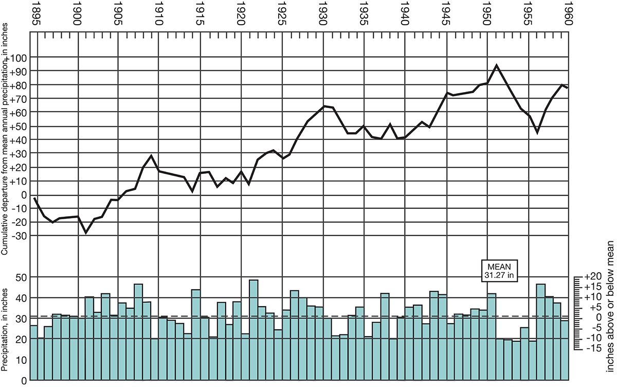
Table 1--Monthly mean precipitation at Winfield.
| Month | Precipitation (inches) |
|---|---|
| January | 1.03 |
| February | 1.33 |
| March | 1.89 |
| April | 3.52 |
| May | 4.25 |
| June | 4.19 |
| July | 3.44 |
| August | 2.74 |
| September | 3.65 |
| October | 2.13 |
| November | 1.77 |
| December | 1.33 |
At Arkansas City the mean annual precipitation is 32.18 inches. The highest annual precipitation of record, 48.20 inches, was in 1957; the lowest, 18.38 inches, was only one year earlier, in 1956.
The annual mean temperature at Winfield is 57.8° F. The lowest temperature of record, -27° F, was on February 13, 1905, and the highest temperature, 118° F, was on August 12, 1936. The minimum temperature is 32° F or below for an average of about 100 days a year, and the maximum temperature is 100° F or above for about 15 days a year. The average wind velocity at the Wichita weather station, which is the nearest station to Cowley County equipped to record wind data, is 12.1 miles per hour. The wind movement is generally strong during the afternoon hours in March and April, but the winds almost always diminish in the early evening. The highest average wind velocity is in April and is about 14 miles per hour. The prevailing winds are southerly except during February, when they are northerly.
The growing season has an average length of 188 days but it has been as long as 213 days and as short as 141 days.
Population
According to the 1959 census, the population of Cowley County was 37,040. The average density was 32.6 persons per square mile compared with 23.2 persons per square mile in the state as a whole. [Note: Cowley County population was listed as 36,291 in 2000 U.S. census, ranking 13th, with a density of 32.2 (32.9 for the state) (KU Institute for Policy & Social Research).] The population of the county has decreased at an average yearly rate of about 133 persons since it reached a peak of 40,903 in 1930. Rural population decreased about 2,000 in the period 1940 to 1950. During this same period the urban population increased about 1,000.
Arkansas City, population 14,606 in 1959 [12,762 in 2000], and Winfield, population 10,848 in 1959 [11,931 in 2000], are the largest cities in the county. Winfield has had a steady growth in population since the city was founded; Arkansas City also has had a steady growth except during the 10-year periods prior to the 1900 and 1940 censuses. All other towns in the county except Burden and Udall have decreased in population since 1930. The populations of the smaller towns in 1959 were as follows: Atlanta, 260 [255 in 2000]; Burden, 670 [564 in 2000]; Cambridge, 161 [103 in 2000]; Dexter, 310 [364 in 2000]; and Udall, 644 [794 in 2000].
Transportation
Cowley County has good transportation facilities. All the cities are served by one or more railroads. Arkansas City, Winfield, and Udall are on a main line of the Atchison, Topeka & Santa Fe Railway. A branch line of the Atchison, Topeka & Santa Fe extends from Winfield through Burden and Cambridge. Arkansas City, Winfield, and Dexter are on a branch line of the Missouri Pacific Railroad. A branch line of the St. Louis-San Francisco Railway passes through Atlanta, Winfield, and Arkansas City. Arkansas City is served also by the Midland Valley Railroad.
Atlanta is the only city in the county that is not on a state or federal highway. U. S. Highway 160 crosses the county from west to east and passes through Winfield, Burden, and Cambridge. U. S. Highway 166 crosses the southern part of the county from east to west and passes through Arkansas City. U. S. Highway 77 traverses the county from north to south and passes through Winfield and Arkansas City. Kansas Highway 15 crosses the county from northwest to southeast and passes through Udall, Winfield, and Dexter. Kansas Highway 55 is a connecting highway from Udall west to U. S. Highway 81 in Sumner County.
County highways are all hard surfaced and give access to the entire county either by direct connection or by connecting to the federal and state highways. Most of the township roads are graded and many are all-weather roads.
Agriculture
Agriculture is one of the principal occupations in Cowley County. About 30 percent (210,000 acres) of the land is cultivated; in addition, about 50,000 acres is used for alfalfa or wild hay production. The total value of the field crops in 1955 was $4,665,000; wheat accounted for about 50 percent of this amount. The principal crops and the acres harvested in 1955 are listed below:
| Crop | Acres |
|---|---|
| Wheat | 96,000 |
| Sorghums | 39,600 |
| Oats | 34,900 |
| Barley | 28,300 |
| Rye | 5,650 |
| Corn | 4,300 |
The value of livestock and livestock products in the county in 1955 was $7,200,000, considerably greater than the value of other agricultural products. Beef cattle accounted for about $5,100,000 of this total. About 60 percent of the land area is pasture or grazing land, and because so much of the land is devoted to this use, the value of beef cattle produced is high. In the order of value, the livestock and livestock products of the county are beef cattle, milk products, poultry and eggs, hogs, and sheep.
Mineral Resources
Oil and Gas
Cowley County has been an important producer of oil and gas for many years. The first discovery of gas in the county was in 1902 in a well drilled just east of Winfield. Natural gas discovered near Dexter in 1903 attracted wide attention because of its helium content. A plant for the extraction of helium was constructed at Dexter in 1927 and operated for a few years. Oil was discovered near Dexter in 1914, but the first important discovery of oil was in 1916. Extensive development began in the early 1920's and production reached a peak in 1925. The annual production of oil since the first discovery is given in Table 2. [Cumulative production as of the end of 2009 was 181,071,245 barrels of oil and 41,383,635 MCF of gas. Additional information can be found at the oil and gas page of the Kansas Geological Survey.]
Table 2--Annual production of oil in Cowley County.
| Year | Production, thousands of barrels |
|---|---|
| 1914 | 15 |
| 1915 | 14 |
| 1916 | 18 |
| 1917 | 29 |
| 1918 | 26 |
| 1919 | 22 |
| 1920 | 60 |
| 1921 | 70 |
| 1922 | 243 |
| 1923 | 629 |
| 1924 | 2,266 |
| 1925 | 7,039 |
| 1926 | 3,943 |
| 1927 | 3,304 |
| 1928 | 2,284 |
| 1929 | 2,065 |
| 1930 | 2,015 |
| 1931 | 1,885 |
| 1932 | 2,743 |
| 1933 | 1,147 |
| 1934 | 1,681 |
| 1935 | 1,622 |
| 1936 | 1,804 |
| 1937 | 1,963 |
| 1938 | 2,318 |
| 1939 | 2,131 |
| 1940 | 2,720 |
| 1941 | 2,816 |
| 1942 | 2,865 |
| 1943 | 2,738 |
| 1944 | 2,614 |
| 1945 | 2,583 |
| 1946 | 2,717 |
| 1947 | 2,813 |
| 1948 | 2,593 |
| 1949 | 2,115 |
| 1950 | 1,908 |
| 1951 | 1,725 |
| 1952 | 2,166 |
| 1953 | 3,197 |
| 1954 | 4,364 |
| 1955 | 4,713 |
| 1956 | 4,595 |
| 1957 | 4,182 |
| 1958 | 4,172 |
| 1959 | 3,858 |
| 1960 | 3,672 |
The 1960 production from 1,648 wells was 3,672,300 barrels. Secondary recovery projects accounted for about one-fourth of this production. Cumulative production to the end of 1960 was about 106,462,000 barrels. Gas production in 1960 was 1,413,000 thousand cubic feet as compared with 1,320,000 thousand cubic feet in 1959.
Most of the oil is produced from the following, informally designated units: the "Layton sand," "Bartlesville sand," "Mississippi lime," and "Arbuckle lime," but a total of 15 zones produce oil in the county. Some gas is produced from the oil-producing zones, but most of the gas is produced from shallow zones in the Admire and Douglas Groups.
Construction Materials
Raw materials in Cowley County that would be useful in construction projects include alluvial deposits in the major stream valleys, chert gravel deposits, and limestones of Permian and Pennsylvanian age. For discussion, these materials are classified as to use.
Concrete Aggregate
Aggregate for concrete consists of fragments of hard, durable minerals or rocks of sand and gravel grain size. The constituent particles should be free from adherent coatings or particles that would interfere with the bonding of the cement and aggregate. An almost unlimited supply of sand and gravel is available from the alluvial deposits in the Arkansas River valley. Crushed aggregate can be produced in large quantities from the Permian limestones in the eastern three-fourths of the county. Material for the manufacture of light-weight aggregate is available, but as most of the Permian shale from which this aggregate would be made is calcareous shale, special manufacturing processes would be necessary. In general the chert gravel deposits and alluvial materials from streams other than Arkansas River are not suitable for aggregate, as these deposits contain much clay and silt that would interfere with the cement bond.
Road Metal
Road-surfacing material is available in large quantities from the alluvial materials in Arkansas River valley and also in smaller supply from the other major streams in the county. Crushed limestone from almost all the Permian limestones is available and has been used without binder on many of the secondary roads in the county. This crushed stone tends to powder and become very dusty in dry weather. Silt deposits in the Arkansas River valley and loess deposits adjacent to the river are suitable as a binder for road-surfacing material. Sand and gravel, crushed limestone, and silt binder are used extensively to build asphalt or macadam roads. Terrace deposits composed of chert gravel formerly were used extensively for road metal and are used on many secondary roads. These deposits contain much clay and silt, which form a good binder but also tend to become very soft and sticky after hard rains. In dry weather this type of road metal does not become as dusty as crushed limestone.
Structural Stone
Structural stone is any hard, dense rock that can be quarried and cut to a desired size and shape. Materials that meet these requirements are found in the Cresswell Limestone Member of the Winfield Limestone and in the Fort Riley Limestone Member of the Barneston Limestone. The Cresswell has been used extensively in the past but little of this stone is being used for structural stone at present. The Fort Riley is widely used for cut stone. Two companies produce cut stone from this rock unit from quarries near Silverdale, about 8 miles east of Arkansas City. Small quarries have been opened in nearly all the thicker Permian limestone units that crop, out in the county. Most quarries from which stone was used principally for local building projects have been abandoned.
Agricultural Limestone
Limestone having a calcium carbonate content equivalent of 80 percent or more and occurring in ledges sufficiently thick for economical quarrying is regarded as a potential source of agricultural limestone. In Cowley County the Fort Riley Member meets the first requirement, its calcium carbonate content being about 95 percent. No Fort Riley quarries were found from which the limestone was being used for this purpose, however. The Cresswell Member is generally suitable for agricultural limestone, although locally the calcium carbonate content may be below the 80-percent minimum. Two quarries about a mile west of Winfield, one of which is now abandoned, have produced rock used for agricultural limestone. Many of the other Permian limestones and some of the calcareous shales would meet the calcium carbonate requirement, but the deposits probably are not thick enough for economical quarrying.
Prev Page--Introduction || Next Page--Subsurface rocks
Kansas Geological Survey, Geology
Placed on web May 21, 2009; originally published August 1962.
Comments to webadmin@kgs.ku.edu
The URL for this page is http://www.kgs.ku.edu/General/Geology/Cowley/03_geog.html