![]()
Prev Page--Contents || Next Page--Geography
Introduction
Purpose and Scope of Investigation
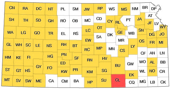
A program of investigation of the ground-water resources of Kansas was begun in 1937 by the U. S. Geological Survey and the State Geological Survey of Kansas with the co-operation of the Division of Sanitation of the State Board of Health and the Division of Water Resources of the State Board of Agriculture. The investigation upon which this report is based was begun in the fall of 1956 and field work was completed in the summer of 1958. The report is similar to other reports that have been completed or are being prepared on other counties in Kansas. The present status of investigations resulting from this program is shown in Figure 1.
Figure 1--Index map of Kansas showing area described in this report and areas covered by other online geologic reports, as of May 2009. For additional information, please visit the KGS Geologic Maps of Kansas Page.
Ground water is one of the principal natural resources of Cowley County. It is the source of all public water supplies, all industrial supplies, and nearly all domestic supplies. Ground water is used to some extent also for irrigation. Fortunately, withdrawal of ground water has not seriously depleted the available water supply, although in some areas the encroachment of water of poor quality has caused the abandonment of wells.
The principal objectives of this study were to determine more fully the quantity of water available and to study the factors affecting the quality of the ground water.
Location and Extent of Area
Cowley County is in the southernmost tier of counties in Kansas and is about 120 miles west of the eastern border of the state. The county is bounded on the west by Sumner County, on the north by Butler County, on the east by Elk and Chautauqua counties, and on the south by Kay and Osage counties, Oklahoma.
The county is one of the largest counties in Kansas, extending 35 miles from north to south and 34 1/2 miles from east to west, and comprising an area of about 1,136 square miles.
Previous Investigations
Many geologic studies have been made of rocks of the same age as those in Cowley County, and in many of the reports of these studies, specific reference is made to Cowley County. Only the most important reports having a direct bearing on the geology of Cowley County are mentioned below. Specific references are cited by author and date at appropriate places in the text; all are given in the list of references at the end of the report.
A report by Bass (1929) described the geology of Cowley County with special reference to the occurrence of oil and gas. O'Connor and Jewett (1952) described the stratigraphy of the Red Eagle Formation in Cowley County. Hattin (1957) in a report on the depositional environment of the Wreford megacyclothem described the Wreford Limestone in Cowley County. Lane (1958) described the environment of deposition of the Grenola Limestone. Verville and others (1958), in a report on the geology, mineral resources, and ground-water resources of Elk County, described the rocks and ground-water conditions common to both counties. A report by Walters (1961) described the geology and groundwater resources of Sumner County, in which geology and ground-water conditions in Pleistocene rocks are similar to those in closely associated equivalent deposits in Cowley County.
Methods of Investigation
About a month in the fall of 1956 was spent drilling auger holes and collecting water samples in the valley of Arkansas River. About 4 months in the summers of 1957 and 1958 were spent mapping the geology and collecting hydrologic data. The geology was mapped on areal photographs and was later transferred to a base map modified from a map prepared by the Soil Conservation Service of the Department of Agriculture (Pl. 1). Data pertaining to the wells were obtained from the owners and drillers, and well depths and water levels were measured with a steel tape from a fixed point. The character of the material below the land surface was determined by studying the cuttings of 196 auger holes drilled in 1956-57 and the logs of 83 test holes drilled in 1944. The chemical character of the water was evaluated from analyses of water samples from 101 test holes. Some of the test holes were sampled at more than one depth to determine whether the quality of water changed with depth.
The wells and test holes shown on Plate 2 were located within the sections by use of an odometer and are accurate to 0.1 mile. Altitudes of the measuring points of the wells and test holes were determined in the field by level parties beaded by E. L. Reavis and C. V. Fishel. The analyses of the samples of water were made under the direction of Howard A. Stoltenberg, chemist in charge of the Sanitary Engineering Laboratory of the Kansas State Board of Health.
Well-Numbering System
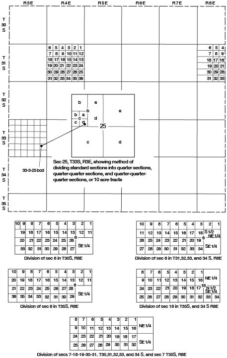
The land in Cowley County is subdivided according to the standard system of the General Land Office except the west tier of sections in Range 8. The wells, test holes, and auger holes in the part of the county containing standard sections are numbered according to the system of land classification of the General Land Office. The component parts of a well number are, in the order given, the township, range, and section numbers, and three lowercase letters, which indicate respectively the quarter section, quarter-quarter section, and quarter-quarter-quarter section in which the well is located. These letters are assigned to the quarter divisions in a counterclockwise direction, beginning in the northeast quarter of each section or subdivision. For example, well 33-3-25bcd (Fig. 2) is in the SE SW NW sec. 25, T. 33 S., R. 3 E. If two or more wells are in the same 10-acre tract, they are numbered serially according to the order in which they were inventoried. The west tier of sections in Range 8 is subdivided so that the east half section is composed of two normal quarter sections, half a mile long from east to west, but the west part, which is about 2 miles long, is divided into lots containing about 40 acres each. The lots are numbered, but the order of numbering differs according to the location of the section in the township. The five section plats at the bottom of Figure 2 show the system of numbering lots in the various sections. In this report a well or test hole in one of these sections is numbered as follows: the township number, range number, section number, and lot number.
Figure 2--Map of Cowley County illustrating well-numbering system used in this report.
Acknowledgments
Appreciation is expressed to the many residents of Cowley County who supplied information and aided in the collection of field data. Special acknowledgment is due the officials of the cities and industries who supplied information about their water supplies. Acknowledgment is made also to Leonard Bailey, driller, and Walter Hunt for information on many wells in the county.
The manuscript of this report has been reviewed by several members of the U. S. Geological Survey and the State Geological Survey of Kansas; Robert Smrha, Chief Engineer, and Harris Mackey, Engineer, Division of Water Resources, Kansas State Board of Agriculture; and Dwight Metzler, Chief Engineer, and Willard Hilton, Geologist, Division of Sanitation, Kansas State Board of Health.
Prev Page--Contents || Next Page--Geography
Kansas Geological Survey, Geology
Placed on web May 21, 2009; originally published August 1962.
Comments to webadmin@kgs.ku.edu
The URL for this page is http://www.kgs.ku.edu/General/Geology/Cowley/02_intro.html