Kansas Geological Survey, Public Information Circular (PIC) 17
Prev. Page--History and Geology
![]()
![]()
![]()
![]()
Kansas Geological Survey, Public Information Circular (PIC) 17
Prev. Page--History and Geology
Lead and zinc mining left behind a number of physical hazards and environmental problems. Over the years, physical hazards such as open mine shafts, collapsed mine shafts, and subsidence areas have claimed lives, caused property damage, and created avenues for water to enter and leave the mines. Subsidence was often a result of the final phase of mining, known as "robbing the pillars," which involved mining the pillars that supported the mine roof. Without these supports, the mine collapsed, eventually causing subsidence at the surface.
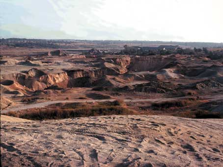
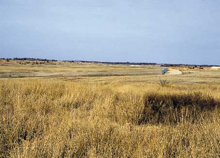
In the early 1980's, the U.S. Bureau of Mines, in cooperation with state geological surveys, conducted detailed studies of the physical hazards associated with the old mining areas. The studies identified more than 1,500 open shafts and nearly 500 subsidence collapse features in the Tri-State. A total of 599 mine hazards were found in and around Galena, Kansas, many of which were concentrated in an area known as "Hell's Half Acre." In 1994 and 1995, the U.S. Environmental Protection Agency (EPA) and local citizens filled in all the mine collapses and shafts in the town of Galena (fig. 5). New top soil was hauled to cover the tailings and boulders in the area.
Figure 5--Galena, Kansas, (top) before (1980) and (bottom) after (1999) reclamation.
The hundred years of mining also left the region with serious environmental problems. When the mines closed, the pumping stopped, and the abandoned tunnels filled with water. The water in these tunnels became contaminated by iron sulfide (from pyrite and marcasite) and other metallic sulfides, which remained in the mine walls or were left behind by the miners. In addition to becoming very acidic, the water contained dissolved metals, some of which are very toxic. This water, in turn, contaminated local ground water, springs, and surface water.
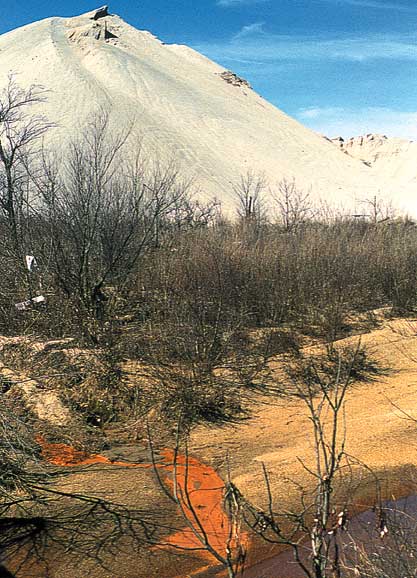
Lead and zinc production involved crushing and grinding the mined rock to standard sizes and separating the ore. This left behind piles of leftover rock called tailings that covered 4,000 acres in southeastern Cherokee County. These wastes were also a source of contamination. Lead, zinc, and cadmium from the tailings leached into the shallow ground water, contaminating local wells; in addition, runoff moved contaminants into nearby streams and rivers (fig. 6). Wind also blew fine metal-bearing dust (from tailings piles and roads made of tailings) into the air, spreading the contamination to nearby non-mined areas. Radon gas from the mining operations was detected in the air around Galena. During the 1980's, this area was considered one of the most environmentally blighted in the nation.
Figure 6--Water contaminated by iron sulfide (orange color in photo) flows from tailing piles into Tar Creek near Picher, Oklahoma.
Some of the cleanup efforts are funded by the U.S. Environmental Protection Agency's Superfund. The EPA began working in the area in the early 1980's and work is ongoing. The EPA divided the Cherokee County site into six subsites that correspond to six general mining locations, including the areas around Galena, Baxter Springs, and Treece, Kansas.
Because the area in and around Galena had some of the worst contamination, early cleanup efforts were centered there. Chief among these was the provision of safe water supply for rural residents whose wells had been contaminated. Two new wells were constructed in the deep aquifer, and a new rural water district was formed that currently provides over 500 households with a long-term source of clean drinking water.
From 1997 to 1999, contaminated soil was removed from 602 residential properties in Galena and replaced with clean backfill and grass sod or seed; fifty additional properties were remediated in 2000 and 2001. Remediation of residential soils has been completed in Treece and is ongoing in Baxter Springs. Cleanup continues at other sites in southeastern Kansas. For more information, check the EPA Region 7's website: http://www.epa.gov/region07/index.htm.
Galena Mining and Historical Museum. Check out the mineral and fossil specimens at this museum, located in the old train depot, 319 W. 7th, Galena, KS 66739 (620-783-2192).
Baxter Springs Historical Museum. Located on historic US-66 (now called US-69 Alternate), Baxter Springs is the oldest cowtown in Kansas. The Historical Museum at Eighth and East Avenues contains a variety of historical exhibits including a full-scale replica of a lead and zinc mine. The museum is open on weekends year round and at various times during the week (620-856-2385).
Tri-State Mineral Museum. A good place to learn more about lead and zinc mining is the Everett J. Ritchie Tri-State Mineral Museum in Joplin, Missouri. It is located in Schifferdecker Park, 4 miles east of the state line on K-66. For more information, contact Tri-State Mineral Museum, 7th & Schifferdecker Ave, Joplin, MO 64801 (417-623-2341).
Schermerhorn Park. Probably the best place to see the Mississippian limestones of the Ozark Plateau is Schermerhorn Park, about 1 mile south of Galena on the east side of K-26. Shoal Creek, one of the major tributaries to the Spring River, flows through the park. This spring-fed, Ozarkian stream has been the major force shaping the features so common to the Ozark region-rolling hills and steep river bluffs. The park sits at the west end of a tall limestone bluff on the north side of the river.
Among the numerous caves carved into the region's Mississippian limestone is Schermerhorn Cave, located within the park. A spring issues from the cave's entrance. The cave entrance can be reached by walking a short distance, but the interior of the cave is not accessible to the public.
Brockie, D. C., Hare, E. H., Jr., and Dingess, P. R., 1968, The Geology and Ore Deposits of the Tri-State District of Missouri, Kansas, and Oklahoma; in, Ore Deposits of the United States, 1933-1967, Volume 1, J. D. Ridge, ed.: York, Pennsylvania, The American Institute of Mining, Metallurgical, and Petroleum Engineers, Inc., p. 400-430.
Buchanan, Rex C., and McCauley, James R., 1987, Roadside Kansas--A Traveler's Guide to Its Geology and Landmarks: Lawrence, Kansas, University Press of Kansas, 365 p.
Dahlinger, Krista L., 1988, The Lead and Zinc Tri-State Mining District of Kansas and Oklahoma -Environmental Considerations: Compass, v. 65, no. 2, p. 120-123.
EPA Region 7, 2008, National Priorities List Fact Sheet, Cherokee County, Kansas: http://www.epa.gov/region07/cleanup/npl_files/ksd980741862.pdf (Aug. 2008).
Haworth, Erasmus, Crane, W. R., and Rogers, A. F., 1904, Special Report on Lead and Zinc: The University Geological Survey of Kansas, v. 8, 543 p.
McCauley, J. R., Brady, L. L., and Wilson, F. W., 1983, A Study of Stability Problems and Hazard Evaluation of the Kansas Portion of the Tri-state Mining Area: Kansas Geological Survey, Open-file Report 83-2, 193 p. Available online.
McKnight, E. T., and Fischer, R. P., 1970, Geology and Ore Deposits of the Picher Field, Oklahoma and Kansas: U.S. Geological Survey, Professional Paper 588, 165 p., 11 plates. [available online]
Ohle, E. L., 1991, Lead and Zinc Deposits; in, Economic Geology, U.S., H. J. Gluskoter, D. D. Rice, and R. B. Taylor, eds.: Geological Society of America, Decade of North American Geology, vol. P-2, p. 43-62.
Pierce, Robert, 1995, Southeast Kansas-Coal Mines and Fossils: KESTA 4th Annual Fall Conference and Field Trip, October 20 and 21, 1995, Guidebook, 23 p.
Ritchie, Everett, 1986, Guide Book to the Tri-State Mineral Museum: Nixa, Missouri, A & J Printing, 83 p.
Prev. Page--History and Geology
Kansas Geological Survey, Public Outreach
Comments to webadmin@kgs.ku.edu
Web version October 2001
http://www.kgs.ku.edu/Publications/pic17/pic17_3.html