![]()
![]()
![]()
Kansas Geological Survey, Public Information Circular (PIC) 37
A complete version of this PIC is available as a pdf document.
Shelby L. Peterie, Richard D. Miller, and Julian Ivanov
Kansas Geological Survey
Seismology is the study of mechanical waves that travel on and beneath the surface of the earth. It was first recognized as a scientific discipline in the 1800s with the emergence of the quantitative study of earthquakes, one of the most common natural sources of seismic waves. Although instruments designed to detect earthquakes date back to 132 A.D. (Dewey and Byerly, 1969), the first modern seismometers were developed and installed in observatories around the world in the late 1800s and early 1900s to study the cause of earthquakes and investigate the structure of the earth's interior (Agnew, 2002). The first network of seismometers and seismographs to record earthquakes in Kansas was established by the Kansas Geological Survey (KGS) in 1977 to assess the level of seismic activity in the state.
As seismic technology and instrumentation improved, active sources were developed to intentionally generate seismic waves for local studies of the earth's subsurface. Common active sources used to transfer energy into the ground include explosives, hammers, and specially designed thumping devices (for example, fig. 1). Because physical properties--such as density, porosity, and saturation--cause seismic waves to travel in distinct ways, scientists can analyze recorded waves to determine the properties of the materials in the earth, map subsurface structures, and study geologic processes.
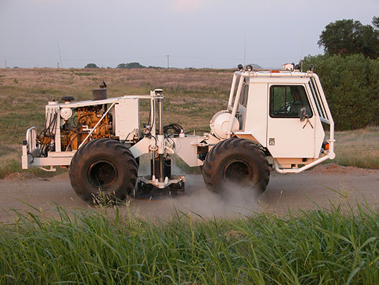
Figure 1--The KGS uses a commercial seismic vehicle, the IVI minivib (shown here in Russell County), to drive a weight into the ground with a series of low-power impacts that produce seismic waves, which are recorded and analyzed.
Active seismic studies became a tool for oil, gas, and mineral exploration in the 1920s, with the earliest published survey conducted in Kansas in 1929 (Weatherby, 1945). As our understanding of how physical properties affect seismic waves has grown, seismology has evolved into a discipline with broad applications ranging from detailed geologic studies to the evaluation of environmental and engineering problems. Today, the KGS uses a variety of seismic techniques to map geologic layers, detect faults and fractures, and evaluate risks to human life and property associated with geologic hazards. This public information circular describes seismic waves, the instruments used to record them, and applications of seismic technologies in Kansas.
As its name suggests, a surface wave travels on the surface of the earth. The most familiar type of surface wave is the Rayleigh wave (fig. 2a), often referred to as ground roll because witnesses describe seeing or feeling the ground "rolling" when this type of wave arrives during an earthquake. On April 24, 1867, during the largest earthquake documented in Kansas, Topeka residents observed that floors of buildings heaved and sank, and ceilings "bent up and down like waves on a pond" (DuBois and Wilson, 1978). These descriptions are consistent with the ground motion caused by Rayleigh waves.
Figure 2--Three types of seismic waves: (a) Rayleigh wave, (b) compressional wave, and (c) shear wave (modified from Bolt, 1993). Arrows indicate particle motion for each wave type.
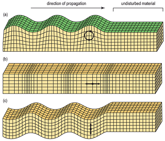
A body wave travels through the earth, beneath the ground surface. The two types of body waves, compressional waves and shear waves, differ in the way particles in the earth move as the wave passes. Particles move parallel to the direction of propagation in a compressional wave (fig. 2b) and perpendicular to the direction of propagation in a shear wave (fig. 2c). Compressional waves travel faster than shear waves in the same medium. Therefore, compressional waves are referred to as primary or P waves because they arrive first and shear waves are referred to as secondary or S waves because they arrive second. Compressional waves travel through gases, liquids, and solids, but shear waves travel only through solids. Body waves are classified into subcategories depending on the path they travel through the earth:
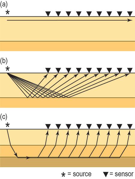
Figure 3--The travel path of a (a) direct wave, (b) reflection, and (c) refraction.
Seismic waves are generated by a variety of sources, both passive and active. Passive sources occur naturally in the earth or as the result of cultural activities. Common passive sources of seismic energy include earthquakes and heavy traffic. Active sources are employed by seismologists to generate seismic waves that are recorded and used to map subsurface rock layers and structures and to evaluate the potential for resources, such as oil, natural gas, and water. KGS scientists use several active sources, including the following:
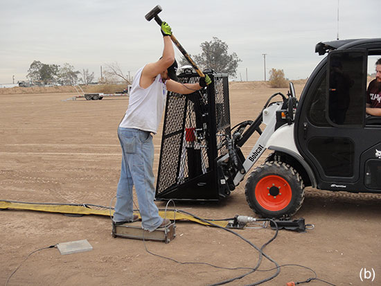
Figure 4--Examples of active seismic sources used by scientists at the KGS: (a) a bungee-assisted weight drop attached to the front of a Bobcat Toolcat (shown here in Galena, Kansas) and (b) sledgehammer and shear block.
The type of sensor used to detect seismic waves depends on whether a passive or active source is being recorded. A seismometer is typically used to detect waves generated by a passive source and is deployed for months or years at a time. Seismometers are often installed on flat surfaces in underground vaults to reduce noise, protect the sensor from the elements, and minimize the negative effects of fluctuating temperature and humidity on the instrument and the quality of the seismic data (McMillan, 2002).
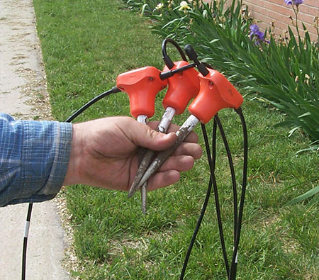
A portable sensor called a geophone (fig. 5) is typically used to detect seismic waves generated by an active source. Geophones are either mounted to short spikes that are inserted into the ground or onto small plates that rest on rigid surfaces (such as concrete). They are temporarily installed and do not require special protection from normal, dry weather. Typically, multiple geophones are deployed in a row or in a two-dimensional array designed to target seismic waves passing through the structure or geologic layers under study.
Figure 5--Geophones used by the KGS for active seismic surveys.
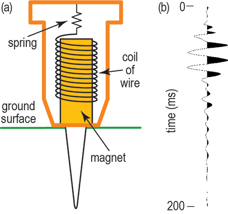
Seismometers are larger than geophones and often more complex, but the internal design of both types of sensors are based on similar principles. The basic concept is illustrated in the diagram of a geophone (fig. 6a). Inside the sensor, a coil of wire suspended by a spring surrounds a magnet that is coupled to the ground. As seismic waves pass through the earth, the magnet moves with the ground, while the coil of wire remains relatively motionless. The moving magnetic field induces an electrical current in the wire, producing a voltage (Reynolds, 1997). A seismograph connected to the sensor records the detected voltage, which is plotted versus time as a seismic trace (fig. 6b).
Figure 6--(a) Diagram illustrating the interior design of a geophone and (b) a seismic trace acquired with a geophone during an active seismic survey in Galena, Kansas.
During a passive survey, a seismograph continuously monitors voltage from the seismometer. The arrival times of P, S, and surface waves observed on a recorded seismic trace can be used to calculate an earthquake's depth and epicenter, the location on the surface of the earth directly above the earthquake. Characteristics of recorded seismic waves can be analyzed to determine additional information, such as the earthquake magnitude and how the rocks in the subsurface moved when the earthquake occurred.
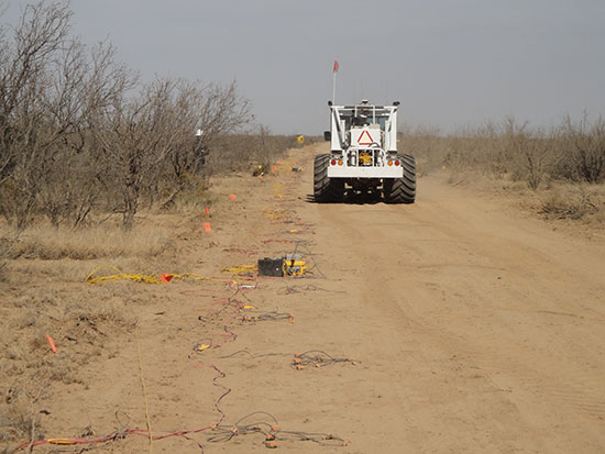
During an active survey, geophones are planted in the ground and connected to a seismograph by cable (fig. 7). Scientists at the KGS typically use 24 geophones for shallow investigations and have used as many as 480 geophones for investigations at depths greater than half a mile. The seismograph receives a signal to begin recording when the source (see figs. 1 and 4) is activated. Seismic traces from each geophone are assembled side by side into a single plot called a seismic record (fig. 8a). The seismic source is then moved to a different location, activated again, and another seismic record is acquired. This process is repeated until the entire study area has been covered.
Figure 7--Geophones connected to seismographs (yellow boxes located next to black batteries) during an active seismic survey.
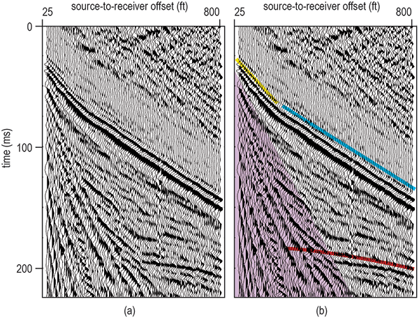
Both surface and body waves are observed on an active seismic record (fig. 8b). Scientists can analyze the recorded surface waves, direct waves, reflections, and refractions to obtain information about the physical properties of geologic layers through which the waves traveled. Images of these layers, generated from the recorded seismic waves using specialized processing routines, are used to interpret subsurface geologic structures.
Figure 8--(a) Seismic record acquired during a survey in Inman, Kansas, with (b) interpreted Rayleigh wave (purple), direct wave (yellow), refraction (blue), and reflection (red).
One of the earliest uses of seismology in Kansas was for oil exploration. In 1935-1936, the Darby Petroleum Corporation acquired active seismic data in Ellis County using P-wave reflection imaging to map a geologic layer known to be oil-bearing. At least 14 oil pools were discovered and successfully drilled based on the results of that study (Koester, 1959), contributing to evidence that active seismic surveys were highly successful for oil exploration in the state. Today, active seismic surveying has become not only standard procedure for oil exploration but also a tool for detecting natural gas (Nissen et al., 2004) and monitoring fluid flow to maximize production in aging Kansas oil fields (Raef et al., 2005).
Seismology has also been used for detailed mapping of geologic structures to better understand the geologic history of Kansas and the role these structures play in earthquakes in the state. In the late 1970s, COCORP, a project supported by the National Science Foundation, funded an active seismic survey east to west across Kansas to image deep geologic structures. The study focused primarily on the Midcontinent Rift, Nemaha Ridge, and Humboldt fault zone (Serpa et al., 1989). From 1977 to 1989, the KGS operated the Kansas-Nebraska Network of seismometers to correlate seismic activity to these geologic structures and to monitor regional earthquakes. During its 12 years of operation, the passive seismic network detected more than 200 microearthquakes. That study shed light on the level of natural seismic activity in the state, which was greater in western Kansas than previously thought (Steeples et al., 1990).
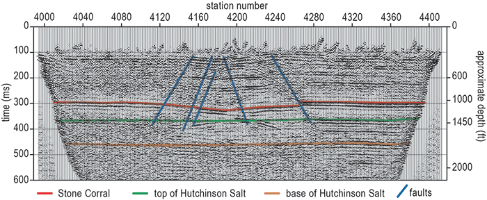
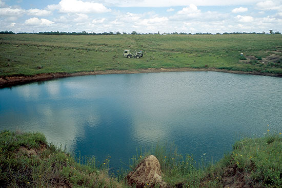
Active seismic surveys have been used for a variety of environmental and engineering applications in Kansas to characterize the shallow subsurface and evaluate risk to existing or future highways, buildings, bridges, and other structures. KGS scientists mapped P-wave reflections and imaged existing sinkholes in south-central Kansas (for example, fig. 9) to help understand how and why the sinkholes formed (Lambrecht and Miller, 2006). Sinkholes occur when the ground collapses into natural or manmade subsurface voids. KGS scientists also have analyzed S-wave reflections and surface waves to evaluate stress above voids and the risk of surface collapse in south-central Kansas near Hutchinson (Miller et al., 2009). In southeastern Kansas, P-wave reflections have been used to map coal beds and interpret locations of abandoned mines (Branham and Steeples, 1988). The information gathered in such studies can be used to guide city planning and future construction.
Figure 9--(a) Interpreted P-wave reflection profile (modified from Lambrecht and Miller, 2006) from a survey acquired at (b) a sinkhole near Macksville, Kansas.
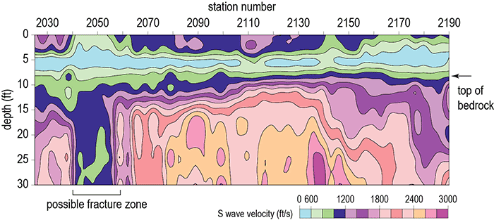
Analysis of surface waves has been used to evaluate bedrock for a variety of purposes in Kansas. For example, surface wave analysis was used in Elk County to select sites suitable for wind turbine installation that were free of subsurface fractures and voids within 50 feet of the surface (Park and Miller, 2005). In Olathe, surface wave imaging was used to map bedrock and identify geologic features that could influence fluid flow in the event of a contaminant spill (fig. 10; Miller et al., 1999). As advances in research are made, seismology will be applied in new ways to further our understanding of Kansas geology, assess a variety of environmental and engineering problems, and mitigate risks associated with geologic hazards in the state.
Figure 10--Shear-wave velocity profile from a survey acquired in Olathe, Kansas (modified from Miller et al., 1999). The increase in velocity at 10-15 ft was confirmed by drilling to be the top of bedrock. Low bedrock velocity between station numbers 2,040 and 2,060 suggests a possible fracture zone.
Agnew, D. C., 2002, History of seismology; in, International handbook of earthquake and engineering seismology, Part A, W. H. Lee, H. Kanamori, P. C. Jennings, and C. Kisslinger, eds.: San Diego, California, Academic Press, p. 3-11.
Bolt, B. A., 1993, Earthquakes: New York, W. H. Freeman, 33 p.
Branham, K. L., and Steeples, D. W., 1988, Cavity detection using high-resolution seismic-reflection methods: Mining Engineering, v. 40, p. 115-119.
Dewey, J., and Byerly, P., 1969, The early history of seismometry (to 1900): Bulletin of the Seismological Society of America, v. 59, p. 183-227.
DuBois, S. M., and Wilson, F. W., 1978, A revised and augmented list of earthquake intensities for Kansas, 1867-1977: Kansas Geological Survey, Environmental Series 2, 56 p. [available online]
Koester, E. A., 1959, A successful seismic program on the Central Kansas Uplift; in, Symposium on Geophysics in Kansas, W. W. Hambleton, ed.,: Kansas Geological Survey, Bulletin 137, p. 351-355. [available online]
Lambrecht, J. L., and Miller, R. D., 2006, Catastrophic sinkhole formation in Kansas: A case study: The Leading Edge, v. 25, p. 342-347.
McMillan, J. R., 2002, Methods of installing United States National Seismograph Network (USNSN) stations--A construction manual: U.S. Geological Survey, Open-File Report 02-144, 23 p.
Miller, R. D., Sloan, S. D., Walters, S. L., Ivanov, J., Leitner, B., Rech, A., Wedel, B. A., Wedel, A. R., Anderson, J. M., Metheny, O. M., and Schwarzer, J. C., 2009, Shear-wave seismic study above Vigindustries, Inc. legacy salt jugs in Hutchinson, Kansas: Kansas Geological Survey, Open-File Report 2009-3, 42 p.
Miller, R. D., Xia, J., Park, C. B., and Ivanov, J., 1999, Multichannel analysis of surface waves to map bedrock: The Leading Edge, v. 16, p. 1,392-1,396.
Nissen, S. E., Watney, W. L., and Xia, J., 2004, High-resolution seismic detection of shallow natural gas beneath Hutchinson, Kansas: Environmental Geosciences, v. 11, p. 129-142.
Park, C. B., and Miller, R. D., 2005, Seismic characterization of wind turbine sites in Kansas by the MASW method: Kansas Geological Survey, Open-File Report 2005-23, 27 p. [available online]
Raef, A. E., Miller, R. D., Franseen, E. K., Byrnes, A. P., Watney, W. L., 2005, 4D seismic to image a thin carbonate reservoir during a miscible CO2 flood: Hall-Gurney Field, Kansas, USA: The Leading Edge, v. 24, p. 521-526.
Reynolds, J. M., 1997, An introduction to applied and environmental geophysics: New York, John Wiley, 796 p.
Serpa, L., Setzer, T., and Brown, L., 1989, COCORP seismic-reflection profiling in northeastern Kansas; in, Geophysics in Kansas, D. W. Steeples, ed.: Kansas Geological Survey, Bulletin 226, p. 165-176. [available online]
Steeples, D. W., Hildebrand, G. M., Bennett, B. C., Park, C., Miller, R. D., and Knapp, R. W., 1990, Microearthquakes in Kansas and Nebraska 1977-1989: Kansas Geological Survey, Open-File Report 90-10, 75 p.
Weatherby, B. B., 1945, Early seismic discoveries in Oklahoma: Geophysics, v. 10, p. 345-367.
The authors would like to thank Cathy Evans, Rex Buchanan, and Bob Sawin for their helpful comments that improved the overall quality of this publication. We also thank Mary Brohammer and Julie Tollefson for illustration and manuscript preparation.
COCORP--Consortium for Continental Reflection Profiling, a project funded by the National Science Foundation to study the structure of the earth's crust in the United States.
direction of propagation--The direction that a wave is traveling.
Humboldt fault zone--A complex zone of faults located along the eastern boundary of the Nemaha Ridge.
Midcontinent Rift--A Precambrian rift that extends from the Lake Superior Region into Kansas and possibly farther south.
microearthquake--A low-magnitude earthquake that is generally too small to be felt or cause damage to manmade structures.
Nemaha Ridge--A buried mountain range composed of Precambrian granite that extends through Nebraska, Kansas, and Oklahoma.
seismograph--An instrument that records seismic waves detected by one or more sensors.
seismometer--A sensor that detects seismic waves generated by earthquakes and cultural activity.
![]()
![]()
![]()
Kansas Geological Survey, Public Outreach
Comments to webadmin@kgs.ku.edu
Web version August 4, 2014
http://www.kgs.ku.edu/Publications/PIC/pic37.html