| Original published in W.W. Hambleton, ed., 1959, Symposium on Geophysics in Kansas: Kansas Geological Survey, Bulletin 137, pp. 351-355 | ||
Koester and Cornell
The complete article is available as an Acrobat PDF file.
This paper describes a successful geophysical exploration program on the Central Kansas Uplift in Ellis, Rooks, Trego, and Rush Counties that resulted in the discovery of 14 pools.
One of the most successful geophysical programs in Kansas was conducted by Seismograph Service Corporation for Darby Petroleum Corporation in 1935 and 1936. Seemingly, it is an example of the accomplishment of geology and geophysics teamwork in a new area even though 75 percent of the area was under lease at the time the program was instituted.
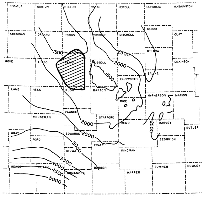
The prospect area consisted of approximately 633,600 acres lying in whole or in part in 36 townships of north-central Kansas. It covered most of Ellis County and adjacent parts of Rooks, Trego, and Rush Counties. This area was chosen because it was believed to occupy a large part of the Central Kansas Uplift (Koester, 1935) as it was known at that time (Fig. 1). Moreover, some open acreage was available. The work required 12 1/2 crew months at a cost of less than $100,000.00, or about 15 cents per acre. Usable records were obtained at 98 percent of the stations shot.
Figure 1--Map showing relation of area covered by Darby Petroleum Corporation seismic program (shown by pattern) to Central Kansas Uplift as known in 1935. Central Kansas Uplift is shown by generalized structural contours on top of Arbuckle dolomite (After Koester, A.A.P.G. Bull. v. 19, 1935).
Reflections were obtained from the top of the Stone Corral anhydrite, of Permian age, at depths ranging from 965 to 1,750 feet. Weatherby (1949) has described the technique that was developed by Geophysical Research Corporation in 1929 for shooting this marker. Stations generally were placed at section corners, but 1/2-mile control was obtained in a few places but covering about 5 percent of the total area.
The Stone Corral anhydrite has a regional dip to the northwest of about 7 feet per mile. Early in the work, it became apparent that northwest-trending noses were structural features suitable for oil accumulation, although some north-south noses also were found to be indicative of the underlying Pennsylvanian and pre-Pennsylvanian structure. In few places did local closures exceed 25 feet. One of the earliest lessons learned in this program was to treat "one-point anomalies" with caution, as some of these were not verified by drilling. It was determined also that a northwest-southeast structural alignment was of more significance than a structure showing a relatively large amount of closure and no regional alignment.
Drilling showed that a "false anhydrite" about 100 feet above the Stone Corral formation could lead to erroneous conclusions as to the presence of structure. For example, the geophysical program outlined a large promising structural feature that conformed to regional structure near the central part of the prospect area. Seemingly, another company also found it by core drilling. A nearby sharp local closure also showed great promise. Both of these prospects were based on "false anhydrite" data and were non-existent and dry when drilled. Fortunately, these disappointments were experienced after the usefulness of the seismic work had been proved by successes elsewhere.
At the time the program was begun, the only oil-producing area in Ellis County was the small Shutts pool in T. 12 S., R. 17 W., which is now part of the Bemis-Shutts field. Also it yielded the only Arbuckle production west of Russell County. There was no oil production at that time in Rush County, although gas had been found in the Albert pool. A few Lansing-Kansas City wells had been completed in the unimportant Wakeeney pool, and the only other oil production in Trego County was the non-commercial Fort Scott production in the Rega pool in T. 13 S., R. 21 W. Both these pools were outside the limits of this shooting program. In Rooks County, four small wells were producing from the Laton pool in T. 9 S., R. 16 W., and the one-well Webster pool had produced some oil in 1930. The Kruse discovery in T. 10 S., R. 16 W., was of small consequence. On the basis of core-drill information, Phillips Petroleum Company had found the Dopita pool in 1934, which produced some from both Lansing-Kansas City and Arbuckle beds. Otherwise, there was no oil production in the four counties in which this work was done, even though each county was heavily leased. The abundant reserves in the Arbuckle dolomite could only be anticipated.
At least fourteen oil pools (shown in black on Fig. 2) have been found because of drilling based on this program. These successes were enjoyed principally by three companies, Darby Petroleum Corporation drilled the discovery wells of the Ellis pool in T. 12 S., R. 20 W., and the Sugarloaf Southeast pool in T. 13 S., R. 17 W., and supported the discovery wells of the Sugarloaf pool in T. 13 S., R. 17 W., the Solomon pool in T. 11 S., R. 19 W., and the Leiker pool in T. 15 S., R. 18 W. However, the Burnett pool in T. 11 S., R. 18 W., was the greatest financial success. Darby Petroleum Corporation had obtained leases on 480 acres in the area at very little cost. When the discovery well of the Burnett pool was completed in 1937, producing 1,900 barrels of oil per day from the Arbuckle dolomite, the company bought the remaining available acreage, which was on an anhydrite closure south of the Burnett discovery well. The 560-acre tract, bought at a cost of $40,000 (an exorbitant sum according to some Kansas landmen), subsequently produced 7,350,000 barrels of oil prior to October 1, 1957, and currently is producing at a rate of 570 barrels per day.
Figure 2--Map showing location of pools discovered as result of seismic program. Pools producing in 1956 are shown by pattern; the seismic discoveries are shown in black.
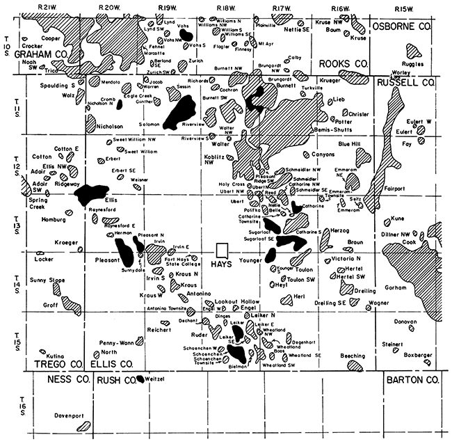
In 1944, Darby Petroleum Corporation was merged with Sunray Oil Corporation, which later discovered the Younger pool in T. 14 S., R. 17 W., and the Pleasant pool in T. 14 S., R. 20 W., Ellis County.
Darby and Bothwell, Inc., drilled the discovery wells of the Vohs pool in T. 10 S., R. 19 W., Rooks County, the Weitzel pool in T. 16 S., R. 20 W., Rush County, and the Cromb and Catharine pools in T. 11 S., R. 20 W., and T. 13 S., R. 17 W., respectively, in Ellis County
The discovery of the Schoenchen pool in T. 15 S., R. 18 W., and the Pleasant North pool in T. 13 S., R. 20 W., by other operators also may be attributed to this program. It is ironic that an exploration test by Darby Petroleum Corporation, which was located by the geophysical work, missed the productive area of the Pleasant North pool by less than 1,000 feet. No doubt other exploratory discoveries in the area may be credited to this program, and additional successes may be expected in the future.
At least fourteen oil pools, which are produced primarily from the Arbuckle dolomite and have appreciable reserves in rocks of Lansing-Kansas City age, have been found because of a seismic program costing less than $100,000.00. The properties that were developed because of these discoveries produced 26,000,000 barrels of oil by October 1, 1957, and currently are producing approximately 6,400 barrels of oil per day. It was difficult or impossible for the company conducting the geophysical program to obtain the desired leases in many places. Except for leases purchased over the Burnett pool mentioned above, the average cost was about $2.00 per acre for the leases obtained as a result of this program.
Koester, E. A. (1955) Geology of Central Kansas Uplift: Am. Assoc. Petrol. Geol. Bull., v. 19, p. 1405-26.
Weatherby, B. B. (1949) Early seismic discoveries in Oklahoma: Geophysical Case Histories, Soc. Expl. Geophys., v. 1, p. 286-287.
Kansas Geological Survey
Comments to webadmin@kgs.ku.edu
Web version Jan. 20, 2014. Original publication date 1959.
URL=http://www.kgs.ku.edu/Publications/Bulletins/137/Koester/index.html