![]()
![]()
![]()
Kansas Geological Survey, Public Information Circular (PIC) 36
A complete version of this PIC is available as a pdf document.
Rex C. Buchanan, K. David Newell, Catherine S. Evans, Richard D. Miller, and Shelby L. Peterie
Kansas Geological Survey
Revised August 2015
Earthquake activity in the Earth's crust is known as seismicity. When linked to human activities, it is commonly referred to as "induced seismicity." Industries that have been associated with induced seismicity include oil and gas production, mining, geothermal energy production, construction, underground nuclear testing, and impoundment of large reservoirs (National Research Council, 2012).
In the early 2000s, concern began to grow over an increase in the number of earthquakes in the vicinity of oil and gas exploration and production operations, particularly in Oklahoma, Arkansas, Ohio, Colorado, and Texas. Horizontal drilling in conjunction with hydraulic fracturing, popularly called "fracking," has often been singled out for blame in the public discourse. The actual process of hydraulic fracturing, however, has been confirmed as the cause of felt earthquakes only a few times worldwide. More often, detected seismic activity associated with oil and gas operations is thought to be triggered when wastewater is injected into disposal wells. In Kansas, both conventional and hydraulic fracturing processes produce saltwater along with oil and gas. In the disposal process, waste products--including saltwater and recovered hydraulic fracturing fluids--are injected into deep and confined porous rock.
Linking a specific earthquake to a specific human activity, such as wastewater disposal at a single well, is difficult. Complex subsurface geology and limited data about that geology make it hard to pinpoint the cause of many seismic events in the midcontinent. However, an established pattern of increased earthquake activity in an area over time may indicate a correlation between human activity and seismic events.
In south-central Kansas, earthquakes started occurring more frequently in 2013, about three years after horizontal drilling, hydraulic fracturing, and subsequent wastewater disposal escalated there. To learn more about the area's subsurface geology in relation to the earthquakes and help determine whether and how fluid disposal through multiple wells is inducing the unprecedented seismicity, the Kansas Geological Survey (KGS) completed installation of a network of temporary monitors in early 2015 to supplement a statewide network. In addition, scientists and others have developed geologically based approaches to identify areas at higher risk and recommendations to help prevent the potential activation of stressed faults by wastewater disposal methods.
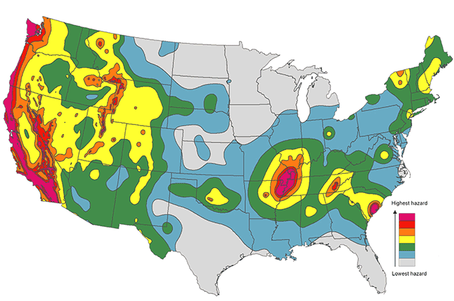
Without factoring in the increased earthquake activity in south-central Kansas, the whole state is generally at low risk for felt earthquakes (fig. 1). Whether the heightened seismic activity--mainly in Harper and Sumner counties (fig. 2)--raises the long-term risk will depend on whether the cause of the earthquakes can be clearly identified and mitigated.
Figure 1--Earthquake hazard maps show the probability that ground shaking will exceed a certain level over a 50-year period. The low-hazard areas have a 2% chance of exceeding a designated low level of shaking and the high-hazard areas have a 2% chance of topping a much greater level (modified from USGS, 2014).
Most seismic activity occurs when stress within the Earth's crust causes a fault or faults in subsurface rocks to slip and release enough energy to generate tremors. The vast majority of earthquakes are instigated naturally where the Earth's tectonic plates interact. In the United States, most seismic activity is on the west coast along the boundary between the Pacific and North American plates. Away from plate boundaries, earthquakes are most often triggered when geological processes, such as the deposition and erosion of surface rock, alter the balance of opposing stresses on subsurface rocks.
The U.S. Geological Survey (USGS) estimates several million earthquakes occur around the world each year, although many small ones go undetected (USGS, 2014). Seismic events too small to be felt on the surface are known as microearthquakes.
Earthquakes can be measured in two ways. One method is based on magnitude--the amount of energy released at the earthquake source. The other is based on intensity--how much the ground shakes at a specific location. Although several scales have been developed over the years, the two commonly used today in the United States are the moment magnitude scale, which measures magnitude (M), or size, and the Modified Mercalli scale, which measures intensity. The moment magnitude scale is now preferred to the older, more familiar Richter magnitude scale because it overcomes some of the limitations of the Richter scale (USGS, 2014).
Measurements on the moment magnitude scale are determined using a complex mathematical formula to convert motion recorded with a seismometer into a number that represents the amount of energy released during an earthquake. Energy released for each whole number measurement is about 31 times greater than that released by the whole number before (USGS, 2014). The smallest earthquakes recorded today on the moment magnitude scale have negative magnitudes (e.g., M -2.0) because the scale's range is based on that of the Richter scale, developed in the 1930s when monitoring equipment was less sensitive. Scientists are now able to detect earthquakes smaller in magnitude than the "0" used as the Richter scale baseline.
Measurements of intensity on the Modified Mercalli Intensity (MMI) scale range from I to XII and are based solely on damage assessment and eyewitness accounts. Intensity measurements near the source of an earthquake are generally higher than those at a distance. Determining intensity can be difficult in sparsely populated areas with few buildings because intensity is calculated largely based on the effects that tremors have on human-made structures.
Although an earthquake's magnitude and intensity measurements are not precisely comparable, they can, in general, be correlated when intensity measurements nearest the epicenter are used in the comparison (Steeples and Brosius, 1996). The magnitude of earthquakes occurring before the introduction of the Richter scale are estimated based on reported damage and intensity. Seismologists categorize modern earthquakes by their magnitude, not by their perceived intensity.
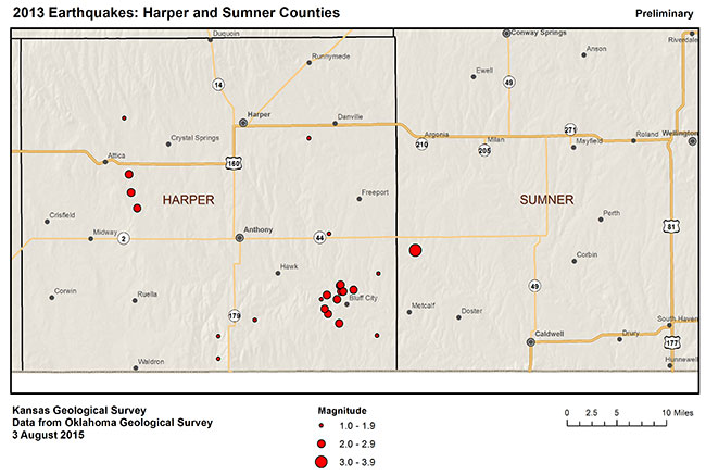
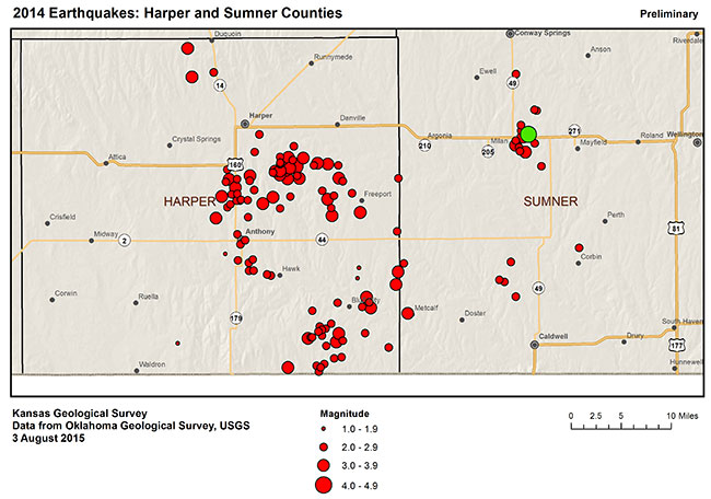
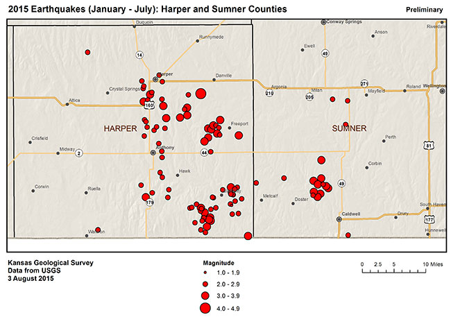
Figure 2--Earthquakes in Harper and Sumner counties in 2013, 2014, and January-July 2015. The green dot on the 2014 map represents the M 4.9 earthquake on November 12, the most powerful event digitally recorded in Kansas. Data from USGS National Earthquake Information Center (NEIC), KGS, and OGS (KGS, 2015).
At least 31 felt earthquakes in Kansas were documented in newspaper accounts and other sources between 1867 and 1976 (KGS, 2015). A few of the later ones were also recorded with seismic equipment. To study earthquakes and identify seismic risk in Kansas, the KGS monitored a temporary network of seismometers throughout the state between 1977 and 1989. The monitoring equipment, which recorded more than 200 earthquakes between M 0.8 and M 4, was sensitive enough to detect artillery fire at Fort Riley from 30 miles (50 km) away and large earthquakes as far away as Japan (Steeples and Brosius, 1996).
Today, the USGS operates two permanent seismic monitoring stations in the state--one at Cedar Bluff Reservoir in western Kansas and the other at the Konza Prairie Biological Station south of Manhattan in northeastern Kansas. In 2014, the USGS installed several temporary stations in the vicinity of the increased earthquake activity in Harper and Sumner counties. Larger Kansas seismic events and smaller ones close to the Oklahoma state line are also picked up by the Oklahoma Geological Survey, which has a network of 30 seismic stations (OGS, 2015).
In late 2014 and early 2015, with funding from the Kansas Corporation Commission (KCC), the KGS installed a temporary seven-station network in south-central Kansas that covers a larger geographic area than the USGS network. The purpose of the KGS network is to pinpoint earthquake depths and epicenters; define zones of increased risk; guide installation of a permanent KGS statewide network; help guide future scientific and regulatory responses to the seismic activity; and gather background geologic data in areas with potential earthquake activity (Buchanan, 2015). Able to record microearthquakes down to magnitudes M 1.5 and possibly lower, the KGS network may help delineate even small faults and fractures. In the first six months, the network detected more than 1,500 earthquakes in Kansas, with an average magnitude of 1.8. By studying data recorded by all of the networks, KGS and USGS researchers have identified an alignment of epicenters south of Conway Springs that suggests a northeast-to-southwest oriented fault or set of faults (Peterie et al., 2015).
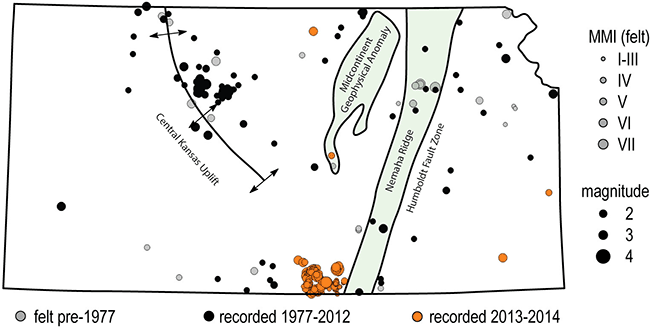
The largest documented earthquake in Kansas, centered near Wamego east of Manhattan in 1867, rocked buildings, cracked walls, stopped clocks, broke windows, and reportedly caused ground to sink and endanger the bank of a canal near Carthage, Ohio (Parker, 1868). Based on damage and reports, the Wamego earthquake was estimated to have a magnitude of 5.2 (Niemi et al., 2004). It was likely associated with the Nemaha Ridge, a 300-million-year-old buried mountain range that extends roughly from Omaha to Oklahoma City. The Humboldt fault zone on the eastern boundary of the Nemaha Ridge is still slightly active (Steeples and Brosius, 1996). Figure 3 shows earthquakes in Kansas through 2014 in relation to the Nemaha Ridge, Humboldt fault zone, and other prominent subsurface geologic structures. Smaller faults and fault systems in the state also have been identified, mainly during oil and gas exploration, but none have been connected with large earthquakes.
Before 2013, the only documented instance of possible induced seismicity in Kansas occurred in 1989 when small earthquakes were recorded near Palco in Rooks County, about 30 miles northwest of Hays. The largest, M 4.0, caused minor damage (Steeples and Brosius, 1996). Several injection wells used for the disposal of wastewater--extracted during conventional vertical oil well operations--were located nearby, and one well in particular may have been close to a deeply buried fault zone. Based on that well's injection history, local geology, and low level of prior earthquake activity in the area, scientists speculated that the seismicity could have been induced (Armbruster et al., 1989).
Figure 3--Prominent subsurface geologic structures in Kansas and earthquakes documented or recorded through 2014 relative to those structures (modified from Hildebrand, 1988).
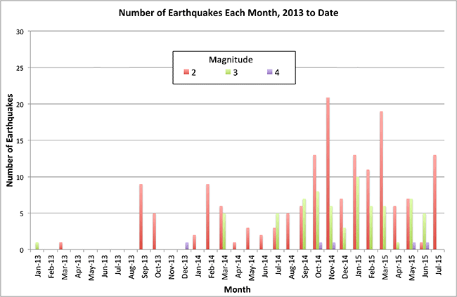
In 2013, 17 earthquakes of M 2 or greater were reported by the USGS for Kansas--most in Harper County (fig. 2a). About three years earlier, drilling in the Mississippian limestone play and associated wastewater disposal crossed the state line into Kansas from Oklahoma. Drilling initially centered on Barber and Harper counties then spread to include Sumner County. In 2014, the number of reported earthquakes in Kansas registering M 2 or greater topped 100. Most were in Sumner or Harper counties, including a 4.9 magnitude event on November 12 about nine miles south of Conway Springs (fig. 2b). From January through July of 2015, more than 100 were recorded, mainly in the same area (fig. 2c; KGS, 2015). Figure 4 illustrates seismic activity in Kansas by month from January 1, 2013, through July 2015.
Scientists are investigating the increasing correlation in both time and location between seismicity in south-central Kansas and oil and gas production activity, including injection of large volumes of saltwater into wells. Although correlation does not equal causation, it does indicate a high probability.
Further understanding of the complex subsurface geology in the region is needed to estimate what impact human activities have on seismicity. Through the KGS's temporary monitoring network, seismologists are collecting vital data about the geology and the earthquakes.
An interactive map showing the latest earthquake activity in Kansas is online at http://www.kgs.ku.edu/Geophysics/Earthquakes.
Figure 4--Earthquakes in Kansas from January 1, 2013, to July 31, 2015, recorded by the USGS. Most were in Harper and Sumner counties in south-central Kansas. Data from the USGS NEIC (KGS, 2015).
The Earth's crust is full of fractures and faults. Under natural conditions, widespread faults deep in the crust are able to sustain high stresses without slipping. In rare instances, pressure from wastewater injected into deep wells can counteract the frictional forces on faults and cause earthquakes. For that to happen, a combination of human activities, natural conditions, and geologic events must occur at the same time. The Earth's crust at the injection well site must be near a critical state of stress and an existing fault has to be nearby--usually within about 10 km (6 mi). Other determining factors include the location and orientation of the fault; the physical properties of the surrounding subsurface rocks, such as density and porosity; and the rate and volume of injected wastewater (National Research Council, 2012). Under most circumstances, a significant amount of water must be injected over a prolonged period to cause a fault to slip and release energy. If a fault does fail, its length and the depth at which it ruptures influence its impact on and beneath the surface.
Many of the Earth's faults are in the Precambrian-age basement rock, which in Kansas lies beneath the deep and confined porous formations used for wastewater storage. Formed 500 million or more years ago, the basement rock is overlain by thousands of feet of sedimentary rock. Injected wastewater may not reach the basement rock, but if pressure created by the injection of fluid into overlying rocks is transmitted into the basement, the potential for induced seismicity increases (Ellsworth, 2013).
Because of their depth, faults within the basement rock are hard to locate. Oil and gas exploration companies, which provide much of the data about the state's subsurface geology, rarely drill that deep. Seismic-reflection techniques used to identify subsurface rocks and faults are expensive and difficult to employ at that depth. Most faults reactivated during wastewater disposal or other activities were unmapped before earthquakes revealed them (Rubinstein and Mahani, 2015). Until more is known about the geology of Precambrian rocks, scientists will not be able to determine with certainty what effect wastewater disposal and other oil and gas field activities have on seismicity.
Hydraulic fracturing is at the center of the debate over induced seismicity in the United States. Microearthquakes, usually less than a magnitude of zero (M 0), do occur during hydraulic fracturing. In fact, geologists often record them to help identify the location of the newly made fractures and to measure stress. However, only a few confirmed cases of felt seismic activity caused by hydraulic fracturing have been documented (National Research Council, 2012). They include five seismic events recorded in Ohio in March 2014 ranging in magnitude from 2.1 to 3.0; a series of events measuring up to M 2.3 in England in 2011; and a series of events ranging from M 2.2 to M 3.8 in a remote area of the Horn River Basin in British Columbia, Canada, between 2009 and 2011 (Skoumal et al., 2015; Holland, 2013; BC Oil and Gas Commission, 2012). Hydraulic fracturing also was suspected of causing a M 2.9 earthquake in south-central Oklahoma in 2011 (Holland, 2013).
Hydraulic fracturing seldom induces felt seismicity because pressurization that occurs during the process usually lasts only a few hours and affects only rocks immediately surrounding the well bore (Zoback, 2012). Wastewater disposal, in which fluids are injected over a longer period, is more often associated with induced seismicity. It has long been recognized that fluid injection can trigger earthquakes. Seismic activity following wastewater disposal at the Rocky Mountain Arsenal near Denver in the early 1960s and by water injection at the Rangely oil field in western Colorado in the late 1960s and early 1970s has been well studied (Zoback, 2012). Although a large quantity of fluid is injected into hundreds of thousands of wells every year, only a small number of those wells have been associated with induced seismicity.
Approximately 172,000 fluid-injection wells in the United States are used for subsurface injection. Of those wells, designated Underground Injection Control (UIC) Class II wells by the U.S. Environmental Protection Agency (EPA), about 20% are used for the disposal of saltwater that is produced along with oil and natural gas. In the disposal process, saltwater is injected into a deep rock formation selected for wastewater disposal and not into the formation from which it was produced. Non-potable water and chemicals used in the hydraulic fracturing process, which must be disposed of under State of Kansas requirements, are also injected into these wells.
Of the remaining 80% of Class II wells in the United States, most are used during secondary and enhanced oil recovery operations to squeeze additional oil out of underground rocks (EPA, 2012). For these operations, saltwater is commonly injected back into the formation from which it was produced. The injected water, ideally, moves toward the production well, transporting additional oil to the well. Earthquakes are much more likely to be associated with disposal wells drilled into deep formations than those used for enhanced oil recovery. Although the injection duration and volume of fluid for both types of wells are similar, injection into a previously undisturbed formation raises pore pressure above initial levels while fluids injected into nearly depleted reservoirs replace the extracted fluids and pore pressure rarely surpasses preproduction levels (Rubinstein and Mahani, 2015).
The EPA regulates the licensing and operation of Class II disposal wells under the Safe Drinking Water Act or delegates authority to state agencies. The act is primarily designed to protect aquifers and other drinking water sources from contamination by injected fluids. Class II well operators submit a form for each well annually indicating total monthly injected volumes and the maximum monthly recorded surface injection pressure.
The KCC regulates the approximately 16,600 Class II wells in Kansas. About 5,000 of those wells are for wastewater disposal and 11,600 for secondary and enhanced oil recovery (KCC, 2014). Class II wells are used only for the injection of fluids associated with oil and gas production. Hazardous and non-hazardous industrial waste, regulated by the Kansas Department of Health and Environment (KDHE), is disposed of in UIC Class I wells. As of August 2015, there were 49 Class I wells in Kansas (KDHE, 2012).
In general, waste fluids from oil and gas production in Kansas are injected back into deep subsurface rock formations "under gravity." That is, fluids are not injected with added pressure but are allowed to flow into these rock formations under the force of gravity. Gravity injection limits the possibility of pressure buildup within a disposal rock formation, which reduces the potential for fault slippage. If fluids are injected at a rate faster than the force of gravity, the added pressure may lower the frictional resistance between rocks along an existing fault system and allow the rocks to slide. Force from fluid weight, independent of injection pressure, also can have an impact.
In response to the increased earthquake activity in south-central Kansas, the governor established the State Task Force on Induced Seismicity in January 2014. With one representative each from the KGS, KCC, and KDHE, the task force held a public meeting to get input from interested parties and developed a protocol to mitigate problems that could result from injection-induced earthquakes. The resulting "Kansas Seismic Action Plan" recommended installation of a KGS statewide seismic monitoring network and outlined an earthquake response plan (KDHE et al., 2015).
Under the response plan, any recorded seismic event in the state of M 3.5 or greater, and some smaller ones in specific locations, would trigger a response. The KGS would determine the magnitude, location, and depth of the event and assign it a seismic action score (SAS) based on those factors plus risk, clustering and timing, and other variables. A low SAS would require no further action. If the SAS were above a set threshold, the KGS would notify the KCC and KDHE, which would determine the location of disposal wells within a 6-mile radius of the epicenter. The KGS would study existing data to identify any known faults in the area. For wells suspected of inducing seismicity, the KCC and KDHE would check the injection history of the wells and pass on all information about the wells to the KGS. Based on injection well data, the KGS could recommend deploying a portable seismic array in the area, and the KCC and KDHE could request more frequent reporting on fluid disposal volumes from the well operators. Based on available data and seismic conditions, the three agencies would determine whether regulatory remedies allowed by statute were warranted (KDHE et al., 2015).
In March 2015, the KCC issued an order requiring operators to reduce the rate of injection into the deep Arbuckle aquifer in five areas of Harper and Sumner counties where the KGS had identified events with high SAS scores. Operators also had to verify the depth of each well and, for any well penetrating below the Arbuckle, cement the bottom up to the base of the Arbuckle. They were required to regularly report data showing compliance with the order, and the KGS continued measuring seismic activity in the areas. The order set a maximum daily injection limit for all injection wells in Harper and Sumner counties, not just in the five areas of concern. Only a small fraction of the 4,300 Arbuckle injection wells currently operating statewide were affected (KCC, 2015).
Although reducing the cumulative rate and volume of saltwater disposal should be beneficial, further monitoring, analysis, and geologic investigation and modeling are needed to determine what effect local geology and disposal reductions have on seismic activity (Walsh and Zoback, 2015).
Armbruster, J. G., Steeples, D. W., and Seeber, L., 1989, The 1989 earthquake sequence near Palco, Kansas: A possible example of induced seismicity (abstract): Seismological Research Letters, v. 60, no. 4, p. 141.
BC Oil and Gas Commission, 2012, Investigation of observed seismicity in the Horn River Basin, http://www.bcogc.ca/node/8046/download? (accessed July 30, 2015).
Buchanan, R. C., 2015, Increased seismicity in Kansas: Leading Edge, v. 34, no. 6, p. 614-617, DOI: 10.1190/tle34060614.1.
Ellsworth, W. L., 2013, Injection-induced earthquakes: Science, v. 341, DOI: 10.1126/science.1225942.
EPA, 2012, Class II wells--Oil and gas related injection wells (class II): U.S. Environmental Protection Agency, http://water.epa.gov/type/groundwater/uic/class2/ (accessed March 27, 2014).
Hildebrand, G. M., Steeples, D. W., Knapp, R. W., Miller, R. D., and Bennett, B. C., 1988, Microearthquakes in Kansas and Nebraska, 1977-87: Seismological Research Letters, v. 59, no. 4, p. 159-163, http://kuscholarworks.ku.edu/bitstream/handle/1808/17375/Steeples_SR_59%284%29159.pdf?sequence=1 (accessed July 30, 2015).
Holland, A. A., 2013, Earthquakes triggered by hydraulic fracturing in south-central Oklahoma: Bulletin of the Seismological Society of America, v. 103, no. 3, p. 1,784-1,792.
KCC, 2014, Injection wells frequently asked questions: Kansas Corporation Commission, http://www.kcc.state.ks.us/conservation/injection_wells_faq.htm#2 (accessed July 30, 2015).
KCC, 2015, KCC issues order reducing disposal volumes in portions of Harper and Sumner counties (news release): Kansas Corporation Commission, http://www.kcc.state.ks.us/pi/press/15-01.htm (accessed July 30, 2015).
KDHE, 2012, Information paper addressing the potential for Class I disposal well operations in Kansas to cause earthquakes: Kansas Department of Health and Environment, http://www.kdheks.gov/uic/download/UICI-IP-1.pdf (accessed July 30, 2015).
KDHE, KCC, and KGS, 2014 [2015], Kansas seismic action plan [amended]: Kansas Department of Health and Environment, Kansas Corporation Commission, and Kansas Geological Survey, http://kcc.ks.gov/induced_seismicity/state_of_kansas_seismic_action_plan_9_26_14_v2_1_21_15.pdf (accessed July 30, 2015).
KGS, 2015, Kansas earthquakes: Kansas Geological Survey, http://www.kgs.ku.edu/Geophysics/Earthquakes (accessed July 30, 2015).
National Research Council, 2012, Induced seismicity potential in energy technologies: National Academy of Sciences, 248 p., http://dels.nas.edu/Report/Induced-Seismicity-Potential-Energy-Technologies/13355 (accessed August 3, 2015).
Niemi, T. M., Ferris, A. M., and Abers, G. A., 2004, Investigation of microearthquakes, macroseismic data, and liquefaction associated with the 1867 Wamego earthquake in eastern Kansas: Bulletin of the Seismological Society of America, v. 94, no. 6, p. 2,317-2,329.
OGS, 2015, Earthquakes in Oklahoma: Oklahoma Geological Survey, http://earthquakes.ok.gov/what-we-are-doing/oklahoma-geological-survey (accessed July 30, 2015).
Parker, J. D., 1868, Earthquakes in Kansas: The American Journal of Science and Arts, 2nd series, v. 45, no. 133, p. 129-131.
Peterie, S. L., Miller, R. D., Intfen, J., Bidgoli, T., and Buchanan, R., 2015, A geologically-based approach to mitigate potentially induced seismicity in Kansas; in, Conference Proceedings, Society of Exploration Geophysicists Annual Meeting, New Orleans, October 18-23, 2015.
Rubinstein, J. L., and Mahani, A. B., 2015, Myths and facts on wastewater injection, hydraulic fracturing, enhanced oil recovery, and induced seismicity: Seismological Research Letters, v. 86, no. 4, 8 p., https://profile.usgs.gov/myscience/upload_folder/ci2015Jun1012005755600Induced_EQs_Review.pdf (accessed July 30, 2015).
Skoumal, R. J., Brudzinski, M. R., and Currie, B. S., 2015, Earthquakes induced by hydraulic fracturing in Poland township, Ohio: Bulletin of the Seismological Society of America, v. 105, no. 1, p. 189-197.
Steeples, D. W., and Brosius, L., 1996 [2014], Earthquakes: Kansas Geological Survey, Public Information Circular 3, 6 p., http://www.kgs.ku.edu/Publications/pic3/pic3_1.html (accessed July 31, 2015).
USGS, 2014, Seismic hazard maps and data: U.S. Geological Survey, http://earthquake.usgs.gov/hazards/products (accessed May 14, 2015).
Walsh, F. R., III, and Zoback, M. D., 2015, Oklahoma's recent earthquakes and saltwater disposal: Science Advances, v. 1, no. 5, http://advances.sciencemag.org/content/1/5/e1500195 (accessed July 30, 2015).
Zoback, M. D., 2012, Managing the seismic risk posed by wastewater disposal: Earth, v. 57, no. 4, p. 38-43, http://www.earthmagazine.org/article/managing-seismic-risk-posed-wastewater-disposal (accessed February 3, 2014).
Arbuckle aquifer--A deep, porous rock group that contains extremely saline water in south-central Kansas and is separated from shallower, freshwater aquifers by thousands of feet of impermeable rock.
Enhanced oil recovery--Production of trapped oil left in the ground following primary and secondary recovery operations by injecting gases, steam, or chemicals through a Class II injection well into a producing formation to lower the viscosity and increase the flow of the remaining oil.
Epicenter--Surface location directly above an earthquake's focus, or point of rupture within the Earth.
Horizontal drilling--Drilling that starts out vertical then gradually turns in a horizontal direction to extend a greater distance into an oil-producing zone.
Hydraulic fracturing--Injection of fluids and sand into a well to fracture oil-bearing rock layers to increase permeability. Colloquially called "fracking."
Mississippian limestone play--A complex group of oil and gas reservoirs within a shared geologic and geographic setting that extends from north-central Oklahoma into south-central and western Kansas.
Rangely oil field--An oil field in northwestern Colorado where the USGS experimented with adjusting fluid pressure in injection wells between 1969 and 1973 to determine how changing injection rates could control seismicity.
Rocky Mountain Arsenal--Established in WWII, the RMA north of Denver was used by the U.S. Army to develop chemical weapons and was later used to produce agricultural chemicals. A deep injection well drilled there in 1961 for the disposal of hazardous chemicals was abandoned in 1966 after 13 earthquakes of M 4 or larger occurred. Earthquake activity declined but continued for two decades (Ellsworth, 2013).
Sedimentary rocks--Rocks formed from sediment, broken rocks, or organic matter, often deposited by wind or water and then compacted into layers after being buried under other sediment.
Secondary oil recovery--Production of residual oil and gas from fields whose reservoir pressures have dropped after initial, or primary, recovery using natural underground pressure and pumping. Water or gas is injected into a Class II fluid-injection well to increase pressure and force oil and gas to the surface through production wells.
![]()
![]()
![]()
Kansas Geological Survey, Public Outreach
Comments to webadmin@kgs.ku.edu
First web version April 10, 2014; revised version Aug. 19, 2015
http://www.kgs.ku.edu/Publications/PIC/pic36.html