Fall 1996
Vol. 2.3
| |
||
| Kansas Geological Survey | Fall 1996 |
Vol. 2.3 |
|
Dakota Aquifer Study Completed
CONTENTS Dakota Aquifer–page 1
|
The Ogallala aquifer, once thought to contain an undepleted supply of ground water in western Kansas, is being consumed 25 times faster than it is being replenished. Concerns over the depletion of the Ogallala have spurred interest in other sources of freshwater. In 1989, the Kansas Geological Survey began an eight-year study of another water source, the Dakota aquifer, which underlies more than 40,000 square miles of western and central Kansas. The purpose of the study, which ended this year, was to investigate the aquifer's potential as a major source of water for western Kansas and to make recommendations to prevent its overuse, says Survey scientist Allan Mcfarlane.
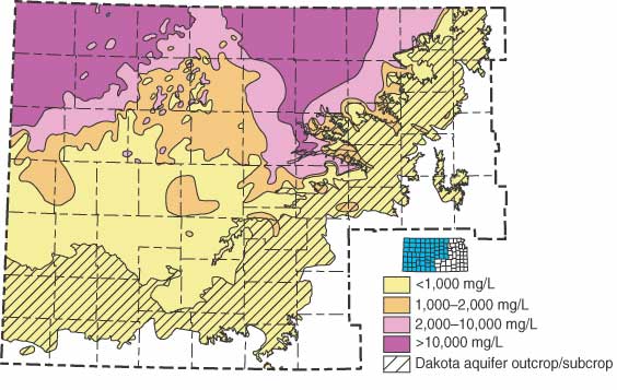
Among the study’s findings is the discovery that the Dakota contains significantly more usable water than was previously thought, particularly in parts of northwestern Kansas. The newly discovered area centers on Sheridan and Graham counties. Don Whittemore, Survey geohydrologist, analyzed salinity and studied the Dakota’s water quality: “Although the additional usable water is slightly saline, the water could be a valuable resource for the future because much of it lies along the eastern margin of the Ogallala aquifer where water supplies are limited.”
The aquifer’s main recharge area is in southeastern Colorado, where the Dakota is at the surface. Freshwater in the Dakota flows northeastward into Kansas, as it has for millions of years. This regional flow has flushed the original saltwater from many parts of the aquifer as it sweeps towards the outcrop area in central Kansas. Flushing has been less effective in extreme northwestern Kansas, because the rocks are less permeable, and in north-central Kansas, where an infusion of saltwater from beneath the Dakota is greater than regional flushing. Although most of the water in this newly found area is too saline for human consumption, it can be used for watering stock or mixed with fresher water for domestic use, which the city of Hays, Kansas, is doing to supplement its water supply. Dakota wells in this area are too deep (about 1,000 feet) to be feasible for irrigation. Kansans will probably not be able to use the Dakota to the extent they have the Ogallala. “The Dakota will not produce water at the same rate as the Ogallala on a sustained basis,” reports Macfarlane. That’s due to the amount of recharge entering the aquifer from rainfall.
Over much of western Kansas, thick, nearly impervious rock units above the Dakota aquifer reduce recharge to the Dakota from precipitation. “In this part of the aquifer, the potential for overuse is the greatest because local recharge is negligible,” notes Macfarlane. “However, users who don’t need the high volumes pumped by irrigators should be able to use the aquifer for small public and domestic supplies and stock watering.”
The major issue that will affect the Dakota aquifer as a resource is
its sustainability under increased development. Acting on the results
of the study, the Division of Water Resources has already revised regulations
that address the minimum spacing between pumping wells in the Dakota.
“Controls on the spacing between pumping wells and rates of withdrawal
are likely to be the most successful management tools,” notes Macfarlane.
“This will reduce the likelihood of water-rights impairment and
large-scale depletion. Once the Dakota is depleted, there are no other
sources of freshwater in the region.” |
|
Concentrations of total dissolved solids (TDS) in
ground water in the Dakota aquifer. Water with less than 1,000 mg/L TDS
is defined as fresh. Water with TDS concentrations above 10,000 mg/L is
classified as unusable. |
 |
| Online February 10, 2003 Comments to: lbrosius@kgs.ku.edu Kansas Geological Survey URL:http://www.kgs.ku.edu/Publications/GeoRecord/1996/vol2.3/Page1.html |