by Lee C. Gerhard,
Director and State Geologist
Meeting the public's need for science requires research on current geologic and environmental issues and the vision to see future needs. One of the Survey's strengths is its ability to identify public needs and build research programs to meet those needs. The Dakota aquifer program is an example of research accomplishment and vision.
In 1987 the KGS recognized that the Ogallala aquifer was over-appropriated and water levels were seriously declining, but an underlying aquifer, the Dakota, had never been studied. In 1988, the Kansas Legislature appropriated funding for a proposed study that would last 14 years and cost $2.6 million. We finished the study in 1996, in eight years, at a cost of $1.6 million. Some results have been released, serving the study's primary purpose: providing for predevelopment management of the resource, in contrast to ex post facto management of the Ogallala.
Four other needs were identified in 1987—providing basic research in support of petroleum exploration and development in Kansas (largely federally funded), documenting stream-aquifer interactions and their effects on water supplies, initiating a new generation of detailed geologic mapping of Kansas, and improving access to our information and research. We continue to determine the issues that Kansans will face in the decades to come. If you have thoughts and concerns, please share them. We seek your help in looking into the future.

Water issues affect all Kansans.
Whether it’s declining ground-water levels in the west or flooding
in the east, nearly every part of the state faces questions about water
quantity and quality.
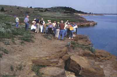
The Survey’s 1996 field conference, held in June, brought together legislators, State agency staff, irrigators, and leaders of business and environmental groups to view and discuss water issues. The three-day conference, co-sponsored by the Kansas Water Office, included conversations about water quantity, quality, and policy issues and made stops that included Quivira National Wildlife Refuge, Big Bend Groundwater Management District at Stafford, Kansas State University’s Sandyland Experiment Field near St. John, Wilson Lake, Cedar Bluff Reservoir, the Circle K Ranch near Kinsley, and Cheyenne Bottoms.
The Survey’s field conference is an annual event designed to provide decision-makers with a first-hand look at natural resource issues. The 1997 field conference, scheduled for June 4–6, will focus on rural/urban land use and environmental issues.
Online February 10, 2003
Comments to: lbrosius@kgs.ku.edu
Kansas Geological Survey
URL:http://www.kgs.ku.edu/Publications/GeoRecord/1996/vol2.3/Page2.html