Kansas Geological Survey, Subsurface Geology 6, p. 40-47
by
D. E. Nodine-Zeller
Kansas Geological Survey
An Acrobat PDF file containing the complete paper is available (800 kB).
"Pennsylvanian basal conglomerate" is a term widely used in Kansas to include reworked Mississippian or Ordovician beds that occur just beneath recognizable Pennsylvanian marine shales, limestones, or sandstones which range in age from Lower Desmoinesian (Cherokee Group) to Lower Missourian (Kansas City Group). The nature of these karst-derived deposits varies from hundreds of feet of heterogeneous rubble and riverine sediments such as those found in the Collins conglomerate to "Mississippi chat," which is essentially cherty residual debris resting on the surface of deeply weathered limestones. The unconformity represented by this unit is a very important one in the Midcontinent area because conditions conducive to the accumulation of oil and gas and to the emplacement of lead, zinc, and silver ores were created during this long post-Mississippian period of karst-type weathering in a tropical climate.
A study of the Midcontinent Petroleum Company No. 1 J. G. Collins borehole was undertaken in order to determine the nature and age of the "Pennsylvanian basal conglomerate" and the stratigraphic units above and below it in a continuous core containing 125 ft of the conglomerate. The core was taken from 4,297 ft in rocks of the Marmaton Group (Desmoinesian Stage, Middle Pennsylvanian Series) to 4,555 ft reported as "Mississippi lime."
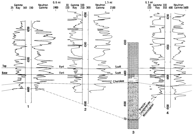
The Midcontinent Petroleum Company No. 1 J.G. Collins, C NW NW sec. 24, T. 20 S., R. 26 W., Ness County, Kansas (fig. 1), elevation 2461 KB, was completed July 27, 1938, as a dry hole. No information on porosity, permeability, or drillstem tests is available. However, net porosity as well as thickness of the conglomerate is known to be highly variable. No wireline or lithology logs were made for this borehole. A graphic geologic section was constructed (fig. 2) showing the nature of beds represented by the core. This section was then correlated with several boreholes nearby that had wireline logs (fig. 5).Figure 1--Location of Midcontinent No. 1 Collins borehole CNWNW sec. 24, T. 20 S., R. 26 W., Ness County, Kansas (Nodine-Zeller, 1981).
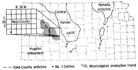
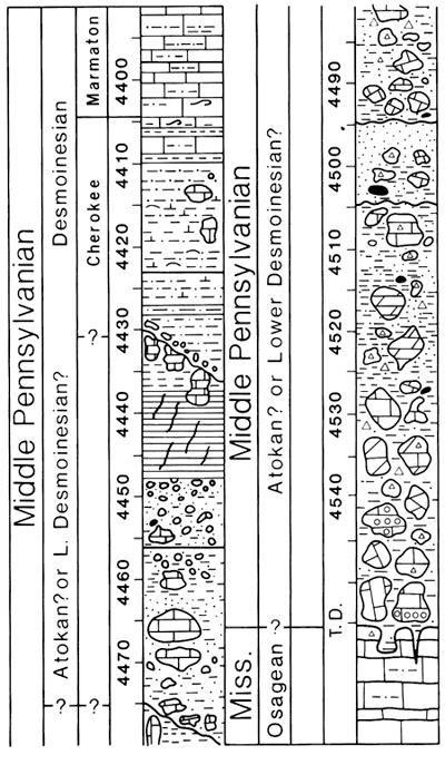
Figure 2--Graphic geologic section showing deposits in Midcontinent No. 1 Collins borehole. T.D. 4,555 ft. Top of paleosol is shown at 4430 ft, with superjacent basal Cherokee conglomerate (Nodine-Zeller, 1981).
The No. 1 Collins borehole is situated 48 mi west-southwest of the western paleoerosional margin of the Central Kansas uplift on a buried anticline (fig. 1). Paleozoic rocks present in this area include the Arbuckle and Viola Limestones of Ordovician age, unconformably overlain by the "Kinderhook shale" or Chattanooga Shale of Devonian age. Mississippian beds include rocks of Kinderhookian, Osagean, and Meramecian age. Rocks of Pennsylvanian age (Desmoinesian, Missourian, and Virgilian Stages) unconformably overlie truncated Mississippian and older strata, with "Mississippi chat" or "Pennsylvanian basal conglomerate" intervening. Permian beds rest disconformably upon those of Pennsylvanian age. Toward the crest of the Central Kansas uplift, younger Pennsylvanian strata successively onlap the older, deeply eroded Paleozoic beds, and there Late Pennsylvanian rocks are in direct contact with Precambrian granites and quartz monzonites.
Figure 3--Weathered stylolitic, fossiliferous limestone cobble of Meramecian age; 4,494 ft. Scale in centimeters.
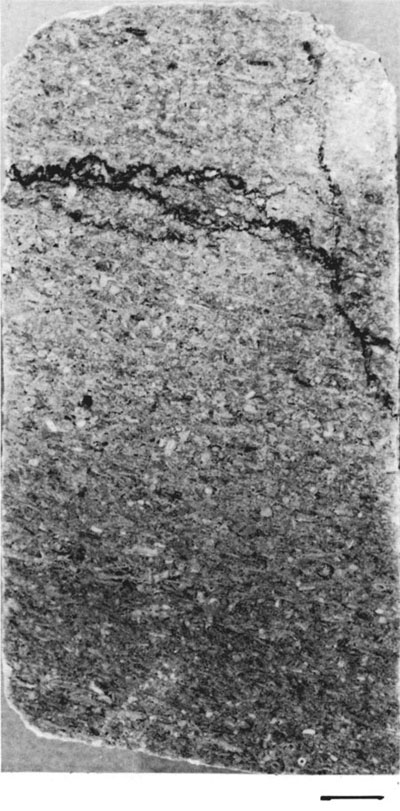
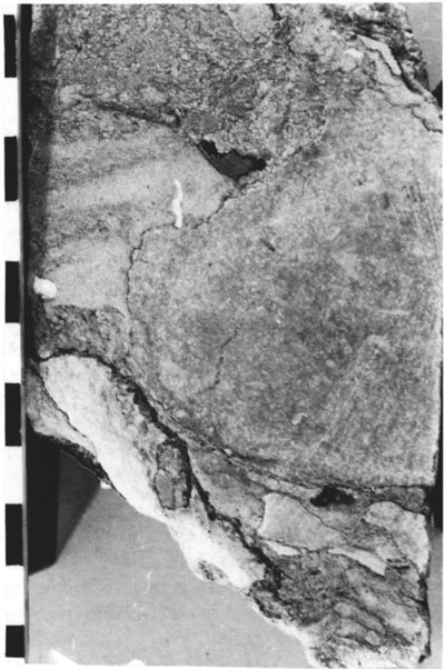
Figure 4--Transported, brecciated Mississippian limestone fragments infilled with sandstone and siltstone matrix beds containing irregular pieces of chalky white chert; 4,475 ft. Scale in centimeters.
The "Pennsylvanian basal conglomerate" produces oil in scattered areas in Ness, Hodgeman, and Gove counties and elsewhere on the Central Kansas uplift. The Aldrich (sec. 7, T. 18 S., R. 25 W., Ness County) and Gorham (secs. 4 and 5, T. 14 S., R. 15 W., Russell County) fields produce from this horizon. The earliest report of production from the "Pennsylvanian basal conglomerate" was in 1927 in the Gorham field in Russell County, where the conglomerate is relatively thin and is almost wholly a sandstone unit referred to as the "Gorham sand" or "Gorham conglomerate" (McClellan, 1930). In 1928 the Stearns and Streator Company No. 1 Mermis, located in SW NW SW sec. 33, T. 13 S., R. 15 W., was completed for an initial production of 1,000 bbls of 36-gravity oil per day (Kesler, 1928). The production came from the top of the "Pennsylvanian basal conglomerate."
Paleontological and physical evidence reveals that the deposits in the No. 1 Collins well represent the "Pennsylvanian basal conglomerate" of early Pennsylvanian (probably Atokan) age which incorporates pebbles, cobbles, and boulders of weathered Mississippian limestones and cherts in a silty, sandy, and shaly matrix that is largely derived from endstage weathering of Mississippian formations ranging in age from Osagean through Chesteran. Evidence also exists of highly weathered Morrowan limestones and shales occurring just beneath Cherokee rocks. The "Warsaw" limestone (figs. 11 and 15) previously reported to be present in the Collins borehole (Thompson and Goebel, 1963) upon closer examination turns out to be only cobbles, pebbles, or boulders of eroded Meramecian limestones incorporated in the "Pennsylvanian basal conglomerate" (Nodine-Zeller, 1981).
That the core interval designated "Pennsylvanian basal conglomerate" was indeed a conglomerate and not solidly bedded limestone was indicated by the following: 1) some cored limestones with a deeply weathered top and bottom, grading into fresh, unaltered fossiliferous limestone at the center of the piece, suggested that this was a cobble or boulder subjected to peripheral weathering as it lay in the permeable matrix of the conglomerate; 2) random repetition of identical lithologies of Mississippian limestones in the core; 3) repeated, scattered occurrences of well-preserved Salem endothyrids in chert fragments ranging throughout the core; 4) several core pieces with bedding parallel to the length of the core; and 5) almost all cored limestones exhibit soft, green clay filling cracks and crevices (figs. 9 and 10) and penetrating even into microscopic interstices.
Figure 5--Correlation of Collins conglomerate with nearby wireline logs. 1) Mull Drilling Company No. 1 Goodman, C SE NE sec. 35, T. 20 S., R. 26 W.; 2) O. A. Sutton No. 1 Goodman, C NE SE sec. 26, T. 20 S., R. 26 W.; 3) graphic section of Collins conglomerate, C NW NW sec. 24, T. 20 S., R. 26 W.; 4) Rains and Williamson Oil Company No. 1 McVicker, C SE NW sec. 24, T. 20 S., R. 26 W. (Adapted from Plate 4, Nodine-Zeller, 1981).
A detailed study of the composition of the "Pennsylvanian basal conglomerate" points to its derivation from solution-prone Mississippian carbonate strata exposed during a period of karst formation in early Pennsylvanian time (see p. 26-28 of Nodine-Zeller, 1981). During the karsting, dolomites and limestones were leached away leaving a thick mantle of residual chert, clay, sand, and silt. The insoluble residues obtained after dissolution of the pieces of Mississippian limestone from this core yield the same types of residues that are found in the matrix of the conglomerate (Nodine-Zeller, 1981). The karst debris, along with other weathered material, was later reworked by ancient streams crossing the Ness County area into channel deposits with thicknesses locally of 100-125 ft in some boreholes. A normal residual mantle is found in other areas with thicknesses on the order of 15-30 ft (fig. 5). No marine fossils are present in the enclosing matrix beds of the conglomerate, and the types of sedimentary structures are those one would expect from fluvial deposition by streams (fig. 17). An abundance of weathered white chert with smooth waterworn surfaces, some exhibiting solution fluting or rill marks, is evidence of long-term stillstand and weathering such as that encountered in karst regimes.
The cored section rests on the eroded top of a normal sequence of sponge spiculites of Osagean age as has been determined from observations of other cores taken in the Ness-Hodgeman County area (Ebanks, Euwer, and Nodine-Zeller, 1977). At the base of the core are cobbles, pebbles, and boulders of Mississippian limestones ranging in age from Osagean to Chesteran (4,555-4,475 ft). Above this, denoting a recognizable change in sedimentation, is a sandstone conglomerate (4,475-4,448 ft). On top of this is a highly weathered, unctuous, red clay shale containing highly weathered limestone cobbles and boulders (4,4484,430 ft). It is in this unit (fig. 13) that a cobble was found that contained the lower Pennsylvanian conodont Idiognathodus. On top of the soil zone are red and green claystone and sandstone with small pieces of Mississippian (and Lower Pennsylvanian?) limestones and cherts in a thin basal conglomerate reworked by transgressing Cherokee seas (4,430-4,429 ft) and grading into marine limestones and shales of middle to late Cherokee age (4,429-4,404 ft) containing Wedekindellina. Above the Cherokee beds is the Fort Scott Limestone of the Marmaton Group (4,404-4,385 ft), whose top was used as a datum on the wireline logs in the cross section in fig. 5.
Figure 6--Large fragments of fossilized (coaly) wood in riverine sandstone; 4,499 ft. Scale in centimeters.
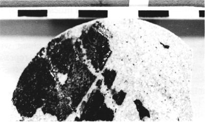
Figure 7--Burrow-mottled matrix sandstone from Collins conglomerate contains tiny fragments of white chert and Mississippian limestone; 4,455 ft. Scale in centimeters.
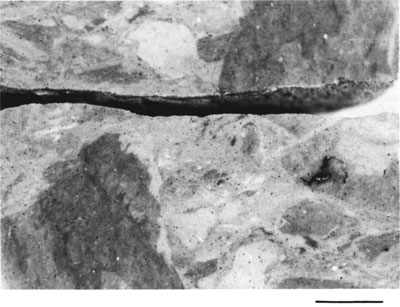
Figure 8--Matrix conglomerate bed of residual materials derived from eroded karsted Mississippian beds. Black material is subbituminous coal; white material is devitrified chert; 4,496 ft. Scale in centimeters.
Beds from the bottom of the core T.D. 4,555 ft to 4,475 ft make up the main unit of the conglomerate, with pebbles, cobbles, and boulders of Mississippian limestone in a matrix of light- to dark-gray, gray-green, and green glauconitic shale, clay, or mudstone and gray, gray-green, and green siltstone, with interspersed beds of gray, gray-green, or greenish-buff, fine- to coarse-grained sandstone. The matrix beds are mostly friable, nonindurated, and noncalcareous (figs. 7, 8, 14, and 16-18). They contain scattered pyrite, sphalerite, chalcopyrite, geodes, mamillary quartz, doubly terminated quartz crystals, beekite rings, drusy quartz, glauconite grains, all types and sizes of quartz grains, aggregates of pyritized spicules, and coaly debris. Dolomitized sponge-spiculite siltstones of Osagean age (fig. 12), enclosed in gray and green clay shales of the conglomerate matrix, were recovered from the base of this interval. Coaly debris and plant fossils (fig. 6) occur in matrix beds throughout the core, and plant fragments were reported by the driller or geologist in matrix beds as low as 4,527 ft. The presence of reworked plant material and coal in these beds indicates a Pennsylvanian age for the matrix beds since the earliest known occurrence of plants and coal in Kansas is in terrestrial Morrowan rocks. The pebbles, cobbles, and boulders of Mississippian limestone are in varying stages of weathering from fresh, with well-preserved fossils, to slightly weathered to completely leached and decalcified with a "rotted" appearance. Large amounts of chert are found in this interval. Some chert fragments are fresh and contain well-preserved Meramecian endothyrid foraminifers, sponge spicules, or other fossils. However, most of the chert is moderately or severely weathered and devitrified to a chalky, white composition.
Beds from 4,475 to 4,448 ft make up a white conglomeratic sandstone and contrast sharply with beds below and above in color and composition. This sandstone is believed to represent a resorting and size-reduction of materials found in the conglomerate below. The color is white to light tan or pinkish-white and pale gray. The sandstone contains much more concentrated glauconite, pyrite, sphalerite, beekite rings, and silicified fossil debris. It is widely variable in composition and includes intraclasts of thinly laminated, angular, pale-greenish-gray and gray sandstone, short stringers and pods of glauconite and glauconitic silt, stringers of sandstone, and sandstone clasts. The quartz in the matrix grades from silt to sand size. Most is frosted and rounded, but some is clear and angular. Throughout this unit are cobbles and pebbles and even smaller clasts of Mississippian limestones.
The interval from 4,448 to 4,430 ft represents a deeply weathered soil profile (fig.2). It contains at bottom a red to greenish-gray to deep-purple unctuous claystone, containing shrinkage cracks that have been recemented with green clay and calcite veins. Above that is a gray, noncalcareous, fossiliferous sandstone, with intraclasts of finer-grained, thinly laminated shaly sandstone with coaly debris, sphalerite, pockets of mud, and pieces of geodes with "dead" oil. On top of that are highly decomposed mudstones and siltstones and pieces of severely weathered limestone, stained yellow and red with limonite and hematite, and shot through with calcite veins (fig. 13).
Beds from 4,436 to 4,430 ft represent the paleosol. No core was recovered in this interval, so lithologic descriptions were obtained from the drillers' log and geologist's report. They recorded limestone with a slight oil show, green lumpy clay, sticky shale, and much sand.
Immediately above the paleosol is the transgressive marine basal Cherokee conglomerate derived from reworking of the soil rubble. It is a pebble conglomerate with coarse sand grains, glauconite, bright red iron stains, and gray-green silt (4,429-4,430 ft). The superjacent beds of Cherokee age are tan to brown, limy siltstones, burrow-mottled gray to gray-green mudstones, and tan to dark-gray biomicrites containing a normal-marine fauna of early Desmoinesian age. In the siltstones and mudstones are still-recognizable Mississippian limestone clasts. The siltstones and mudstones are interbedded with limestones that contain lumps of pyrite and disseminated pyrite, glauconite, and rip-up shale clasts. Several zones in this interval contain broken fusilinids and other fossil hash, along with reworked lithoclasts, and are interpreted as representing disturbed sedimentation due to transgressive-regressive episodes during early Cherokee time.
Establishment of normal-marine conditions is represented by the Fort Scott Limestone at 4,404 ft. Very tiny Mississippian limestone clasts are still to be seen in this silty algal limestone containing ostracodes, pelecypods, bryozoans, and a wide variety of foraminifers, including fusulinids.
Ebanks, W. J., Jr., Euwer, R. M., and Nodine-Zeller, D. E., 1977, Mississippian combination trap, Bindley field, Hodgeman County, Kansas: American Association of Petroleum Geologists, Bulletin, v. 61, no. 3, p. 309-330.
Kesler, L. W., 1928, Oil and gas resources of Kansas in 1927: State Geological Survey of Kansas, Mineral Resources Circular 1, v. 29, no. 11, 60 p.
McClellan, H. W., 1930, Subsurface distribution of pre-Mississippian rocks of Kansas and Oklahoma: American Association of Petroleum Geologists, Bulletin, v. 14, no. 12, p. 1,535-1,556.
Nodine-Zeller, D. E., 1981, Karst-derived Early Pennsylvanian conglomerate in Ness County, Kansas: Kansas Geological Survey, Bulletin 222, 30 p. [available online]
Thompson, T. L., and Goebel, E. D., 1963, Preliminary report on conodonts of the Meramecian Stage (Upper Mississippian) from the subsurface of western Kansas: Kansas Geological Survey, Bulletin 165, part 1, 16 p. [available online]
(Based on a published report "Karst-derived Early Pennsylvanian conglomerate in Ness County, Kansas," Kansas Geological Survey, Bulletin 222, 1981).
Figures 9-10--Brownish-gray Mississippian limestone cobble with fractures and crevices infilled with light-green clay residuum; 4,491 ft. Scale in centimeters.
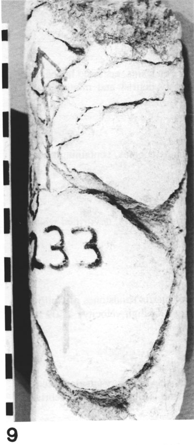
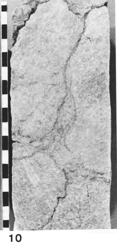
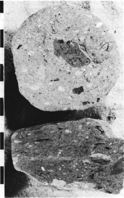
Figure 11--Leached, dolomitized "Warsaw" cobble with oomoldic porosity. Typically occurring fenestellid bryozoan at top of photograph. Such cobbles are often identified as "Warsaw" Limestone because of the presence of fenestellid bryozoans of this type (see fig. 15 also); 4,520 ft. Scale in centimeters.
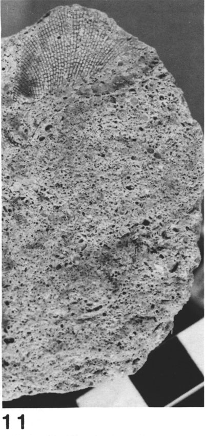
Figure 12--Argillaceous Osagean sponge-bed cobble or boulder containing dark sponge debris and white siliceous sponge spicules. Some cobbles and boulders are very well preserved and display irregular, wispy, high-angled bedding surfaces. Others are thoroughly weathered to a uniform light-tan color and are demineralized and dolomitized, with bedding structures obliterated; 4,549 ft. Scale in centimeters.
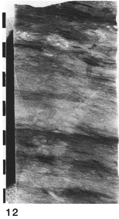
Figure 13--Extremely weathered argillaceous limestone from paleosol zone in Collins conglomerate, showing stylolites with iron oxide deposits, veins filled with calcite, tiny rounded blebs of iron oxide, and irregular patches in limestone that have been reduced to ochre-colored limonitic clay; 4,436 ft. Scale in centimeters.
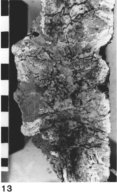
Figure 14--Conglomerate matrix bed of light-colored, fine-grained sandstone with iron stains, enclosed in coarse sand and silt containing particles of white chert, glauconite, black flecks of coaly debris, and minute gray claystone clasts; 4,456 ft. Scale in centimeters.
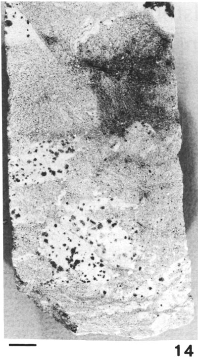
Figure 15--Highly leached, porous, dolomitized Meramecian ("Warsaw") limestone cobbles, containing traces of fenestellid bryozoans; 4,520 ft. Scale in centimeters.
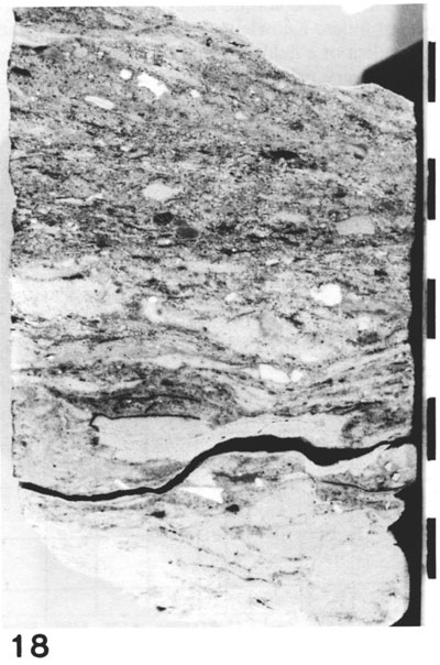
Figure 16--Heterogeneous mixture of sand and silt grains, flakes of shale, mudstone stringers, devitrified white chert, glauconitic stringers, and blebs of pyrite; 4,513 ft. Scale in centimeters.
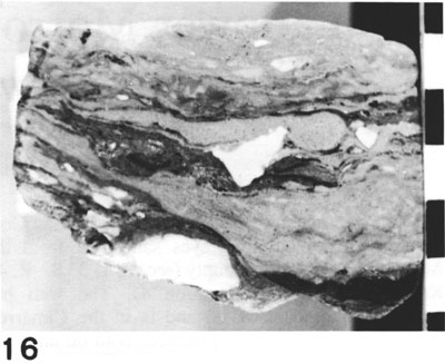
Figure 17--Penecontemporaneous recumbent folds in trough cross stratification of matrix sandstones of Collins conglomerate formed in water-saturated sandstone beds, produced by current surges of high velocity; 4,509 ft. Scale in centimeters.
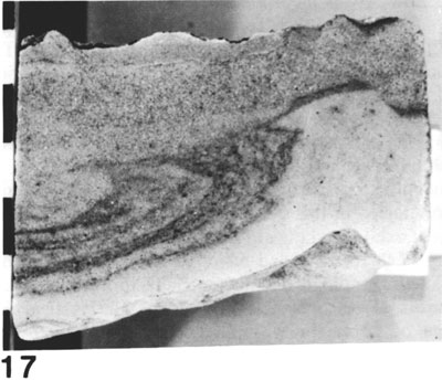
Figure 18--Debris-laden glauconitic sandstone matrix beds containing sand and silt stringers, tiny angular pieces of white tripolitic chert, and mixed Mississippian limestones, finely comminuted and stringers of coaly debris, and varicolored claystone clasts; 4,509 ft. Scale in centimeters.
Kansas Geological Survey
Comments to webadmin@kgs.ku.edu
Web version April 13, 2010. Original publication date 1985.
URL=http://www.kgs.ku.edu/Publications/Bulletins/Sub6/Zeller/index.html