Kansas Geological Survey, Subsurface Geology 6, p. 145-160
by
Anthony W. Walton1 and Gary Griffith2
1University of Kansas
2TXO Production Co.
An Acrobat PDF file containing the complete paper is available (1.1 MB).
N. W. Bass (1929) pointed out that in the subsurface of Kansas, oil occurs in long, narrow "shoestring" sandstones, such as those in the Cherokee of the Cherokee Basin, and sheetlike bodies, of which he gave the "Stalnaker" of the Sedgwick Basin as an example. Over the years, many geologists have debated the origin of these types of sand, especially the famous shoestrings. Recent opinion seems to be settling on a fluvial or delta distributary origin for shoestrings, which are especially characteristic of the Pennsylvanian here.
Few examples of the sheetlike type have been documented, and less is known of their origin. Recent exploration by TXO Production in Harper County led to gas discoveries in the "Stalnaker" interval. In the course of development activities, TXO took a 60-ft core of "Stalnaker" in their Robinson C-1 well, sec. 20, T. 37 S., R. 8 W. in the Sullivan field in Harper County (figs. 1, 2, and 3). Careful examination of this core indicates that the sandstones it sampled accumulated in a deltaic environment.
Figure 1--Location map of Robinson C-1 well.
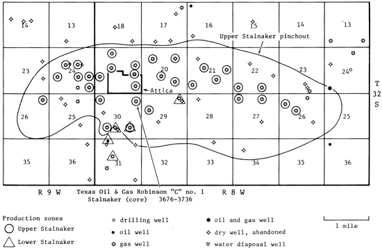
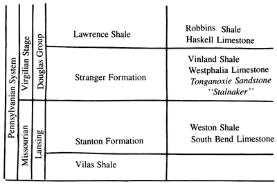
Figure 2--Stratigraphic subdivision of upper Missourian and lower Virgilian rocks in Kansas.
In the Robinson C-1 core, various environments of deltas are represented, especially the distributary mouth bar and the splays and bays of the delta platform. This core includes very good examples of the sedimentary structures and the episodic bedding characteristic of delta-front environments where river floods, marine storms, and day-today processes create a complexly variable environment. Superimposed upon this variability are larger cycles reflecting prograding and foundering delta lobes, or perhaps changes of sea level. Structures and sequences in this core are remarkably similar to those described for the modern Mississippi Delta (Coleman and Prior, 1980).
Cores such as this one are our best source of data for interpreting environments of deposition of sandstones. Information on environments of deposition is useful in many aspects of the petroleum industry. Reconstruction of paleogeography points to areas where porous rock may have accumulated. Offsets to discovery wells are best planned with knowledge of how the reservoir rocks formed. Mapping of reservoirs is guided by interpretation of environments. Estimates of reserves should be tempered by knowledge of likely size range of sand bodies of various origin. Finally, effectiveness of secondary and tertiary recovery efforts is controlled by continuity, orientation and mineral content (both primary and diagenetic) of the reservoir rock. These are controlled by depositional environment. Using information from cores for calibration, it is possible to use well logs, and sometimes even cuttings, to map sand types in the subsurface.
The authors thank Hal Brown of TXO Production, Wichita, for permission to present results of this investigation.
Sandstone was first encountered in the Stranger Formation in south-central Kansas in 1914, when gas was discovered on the Stalnaker farm in Sumner County (Winchell, 1957). Further exploration led to discovery of oil nearby, and the formation has been productive since.
Winchell (1957), in a subsurface study, found that the "Stalnaker" sandstone occurs in the same interval as the Tonganoxie Sandstone of the outcropping Stranger Formation of the Douglas Group (Virgilian;Late Pennsylvanian) in southeastern Kansas (fig. 3). Ball (1964), in his exhaustive treatise on the Douglas, confirmed Winchell's correlation, which had been originally suggested by Lukert (1949). Sanders (1960) and Lins (1950) examined surface and subsurface distribution of sandstone of the Stranger Formation in northeastern Kansas. Griffith (1981) filled a gap between the area Sanders mapped and that which Winchell mapped, so that the distribution of sand in the Stranger over the entire area from the outcrop to the Nemaha uplift, and beyond into Harper and Kingman counties is known. These studies, especially Winchell (1957) and Ball (1964), point out that the limestone above the "Stalnaker" in south-central Kansas, sometimes called "Iatan, " is in fact the Haskell Limestone at the base of the Lawrence Shale of the Douglas Group.
Figure 3--Environments of sand deposition in the Tonganoxie Sandstone Member of the Stranger Formation.
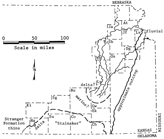
The Tonganoxie (or "Stalnaker") Sandstone of south-central Kansas grades into shale along a line running from southwestern-most Montgomery County northwestward across Chautauqua and Greenwood counties, then westward into Sedgwick County (fig. 3). North of that line, in southern and central Greenwood County and central Butler County, only isolated patches of sandstone in the Tonganoxie, perhaps channels, were found in shale by Winchell (1957) and Griffith (1981). To the west in northwestern Harper County and Barber County, the interval between the older Lansing Group and the Haskell Limestone decreases sharply. Winchell (1957) believed that the Tonganoxie overlies the Lansing unconformably. Ball (1964) convincingly argued, for the eastern part of Winchell's area, from Elk County to Sedgwick County, that the Stanton Limestone of the Lansing Group undergoes a southward facies change to terrigenous sandstone and shale, but no section has been removed by erosion from its top. Winchell's (1957) and Griffith's (1981) cross sections, however, show the rapid thinning of the Tonganoxie in Harper and Kingman counties and the complementary thickening of the Lansing.
In northeastern Kansas, sandstones in the Tonganoxie make a long, linear pattern running southwest or south-southwest from their outcrop in central Douglas County and southern Leavenworth County into the subsurface as far as southeastern Lyons County. The sandstone body is lens shaped in cross section. Its lower boundary lies on different units in different places, cutting as low as the Stoner Limestone Member of the Stanton Formation in places (Lins, 1950; Sanders, 1959). Sanders (1959) also shows another band of sandstone in the Tonganoxie, in the subsurface 30-50 mi west of the first band, but merging with it in southeastern Lyons County. In northern Greenwood County, the pattern of isopach thicks and thins of the Tonganoxie in both Sanders' (1959) and Griffith's (1981) maps is irregular and complex. A possible interpretation of the subsurface data of Sanders and Griffith is a set of fluvial channels feeding a delta in northern Greenwood County, north of the area where little sand was deposited.
The overall pattern of deltaic sandstone in south-central Kansas and adjacent Oklahoma (the "Stalnaker") and fluvial and deltaic sandstone in northeastern and east-central Kansas with an area of marine sedimentation between and to the west has been described by Rascoe (1978) and Moore (1979) for the Midcontinent area in the early Virgilian. Sources of terrigenous sediment lay both to the northeast and north and to the south or southeast.
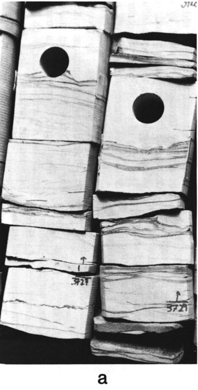
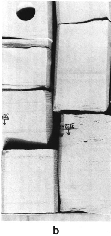
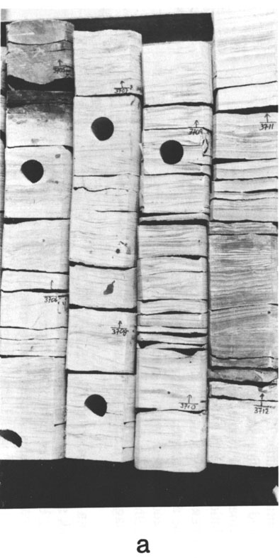
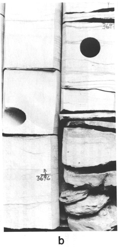
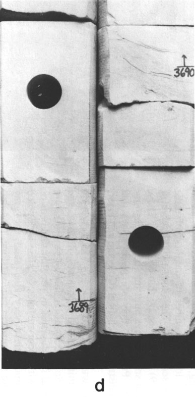
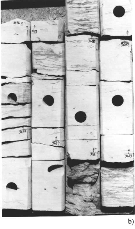
Figure 4--Photographs of the Robinson C-1 core; cores are marked with depth in ft. a) Interval 1--showing rippled or laminated sandstones and wavy or lenticular-bedded sandstone and mudstone. Sands have sharp bases and some have gradational tops. b) Interval 3--episodically deposited sandstones showing laminae, some ripples, and rare mudstone interbeds. Sands have scour surface at base, laminated lower parts, and rippled tops, and may grade into mudrock. c) Intervals 4, 5, and 6-interval 4 resembles interval 1 or 2. Interval 5 is an upward-coarsening cycle from lenticular-bedded mudstones to rippled sandstones. Interval 6 contains peculiar, varve-like siltstones a few cm thick (beginning at 3,715.7). d) Intervals 6, 7, and 8-interval 7 is another upward-coarsening sequence, but it is thinner than the ones above and below. It contains varve-like laminae at about 3,713.5 and a mottled interval just below 3,712.
Parts of the upper and lower "Stalnaker" (i.e., Tonganoxie) Sandstone. This core is in the collection of the Kansas Geological Survey at Lawrence, Kansas.
Rippled sandstone with mud interbeds. Sand beds 0.1-10 cm thick, mud beds up to 0.5 cm thick. Thicker sands may be laminated (fig. 4a).
This interval shows evidence of frequent changes of current conditions. It contains several fining-upward intervals about 5 cm thick that show decrease of current velocity: the intervals begin with a scour surface, pass upward into laminated fine sandstone, then into rippled very fine sandstone and wavy-bedded sandstone and mudstone interbeds. Where these sequences are not present, the rock consists of wavy-bedded sandstone and mudstone interbeds. Ripples in both situations may be bidirectional.
This sequence can be attributed to an environment where waves were the dominant process of sorting and depositing sediment. Fining-upward sequences represent storms, the interbeds represent either normal conditions or weaker storms. Lack of burrowing suggests either rapid sedimentation or conditions toxic to organisms. Sands are seldom deposited in toxic marine environments, so rapid sedimentation is the more likely explanation. Association of this interval with overlying rocks (intervals 2 and 3) that imply more agitated conditions and rapid sedimentation are consistent with the interval 1 being delta-front deposits within an overall delta sequence.
Fining-upward sequences of scour surface-laminated fine sandstone-rippled very fine sandstones-flaser-bedded sandstone. Very similar to storm sequences of interval 1, but no associated lenticular beds. This could represent a slightly shallower part of the delta front than does interval 1 .
Mostly laminated fine sandstone, but interbeds of mud or very fine, rippled sandstone separate the interval into upward-fining sequences 2-60 cm thick (fig. 4b). Sequences begin with a scour surface. All have laminated lower parts; some have rip-up clasts within their lower parts. The laminated interval makes up nearly all of the sequence. At the top of each sequence is a relatively thin layer of rippled very fine sandstone or lenticular-bedded sandstone and mudstone.
These beds indicate episodic sedimentation, short bursts of activity (erosion, followed by deposition as current decreased) alternating with periods of little or no sedimentation. Ripples seem to be wave-influenced current ripples. This type of deposition could occur in proximal parts of delta fronts where storms rework sediment deposited by fluvial activity.
Laminated fine sandstone with interbeds of mudstone (fig. 4c). Sparse burrowing in mudstones.
This interval represents a transition to less-agitated conditions. Within a delta, such a transition could occur between the proximal delta front and delta plain bays, lagoons, and marshes. It could also represent subsidence or transgression and a return to more distal conditions. Overlying intervals suggest a delta plain environment.
Linsen-bedded mudstone and very fine sandstone, sparse burrowing (fig. 5c).
Interval 5 is the lowest member of the first of three upward-coarsening sequences. The other two (interval 7 and intervals 8 and 9) are capped by thin coal beds. These sequences represent small splays built into bays or lagoons on the delta plain. Probably, they are levee splays that developed along a distributary channel (Coleman and Prior, 1980).
Laminated to thinly bedded sandstone, siltstone, and mudstone (fig. 4d). Some beds or laminae of sandstone are rippled. This interval is dominated by peculiar thin beds or laminae that begin with scour surfaces overlain by rippled very fine sand, structureless very fine sand, or gray siltstone, pass up into structureless gray siltstone, then into mudstone (fig. 4c, d). These sequences as a whole give the interval its thin-bedded or laminated appearance, in contrast to interval 3, where the laminae are upper-flow-regime bed forms. The laminae or thin beds in interval 6 show ripples in some cases, but otherwise could be products of deposition from suspension.
Interval 6 overlies interval 5 gradationally; together they form an upward-coarsening sequence, representing a levee splay built into a bay or lagoon or a subdelta. Ripples in this interval, as in intervals 7, 8, and 9, are all unidirectional within each block of core. This suggests current deposition without significant wave influence. Interval 6 is abruptly overlain by interval 7.
An upward-coarsening sequence beginning with streaked muds that pass upward into lenticular-bedded muds and sands, then into laminae of the kind described in interval 6, but thinner. Above these are lenticular beds, with a higher proportion of sand and thicker beds than the sequence just below. The top is root-marked very fine sandstone and seat earth with a very thin (0.5-cm) coal (fig. 4d).
This interval probably can be assigned to the same environments as intervals 5 and 6, a splay of levee material built into a delta-plain lagoon.
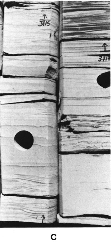
Figure 5--Photographs of the Robinson C-1 core; marks give core depths in ft. a) Intervals 8 and 9--a complete upward-coarsening cycle, interpreted as a levee splay, occurs between 3,712 and 3,705.2. Some streaked shales of interval 10 appear above the coal at 3,705.2. b) Intervals 10 (very top) and 11--shales with large plant fragments are in interval 10. Interval 11 is rippled (especially at 3,696 and below) or laminated, similar to intervals I through 4, but contains no wave ripples. c) Interval 11--rippled sandstones. d) Interval 12--contortions (3,690.3) and small-scale crossbeds (3,688.2).
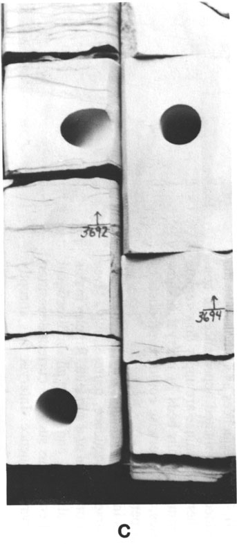
Coarsening-upward sequence, beginning with streaked muds, passing into peculiar laminae like those in intervals 6 and 7, then into rippled very fine sandstone and siltstone (fig. 5a). Some deformation of ripple sets has occurred. Interval 8 passes gradationally into interval 9.
Rippled sandstone and siltstone, grading upward into a root-marked zone and capped with a coal (fig. 5a). Intervals 8 and 9 together could represent a levee splay building into a bay or lagoon on a delta plain, adjacent to a delta distributary.
Major shale break separating lower and upper "Stalnaker" sands (fig. 5a, b). Lower part of this interval is sparsely burrowed, streaked shales. Upper part is mostly claystone with some streaks of silt. Large fragments of plants are common on bedding planes; these are far larger than the fragments in any other interval.This interval could be interpreted within the delta model as having formed in a delta-plain environment where conditions permitted preservation of large plants, but not of shells of animals. The large size of the plant debris argues against assigning this facies to a more distal environment, such as a marine shelf. Probably this sediment accumulated in an open bay on the delta plain.
Rippled very fine to fine sandstone, some interbeds of siltstone at base (fig. 5c). Some laminated fine sandstone at 3,697 ft. No overall grain size change, except upward-coarsening at very base, and no obvious development of grain-size sequences within the interval.
This interval is difficult to interpret. It could be a distributary mouth bar developed into the lagoon or bay represented by interval 10 or part of the channel represented by intervals 12 through 14. The bar interpretation is more likely because the general flow regime was lower than that in interval 12, which is unlikely in normal channel situations. Interval 11 differs from delta-front deposits in the lower Stalnaker because of the lack here of important wave influences on the ripples. Hence this unit probably represents progradation of a crevasse splay into a bay or lagoon on the delta plain.
Laminated to low-angle crossbedded fine sandstone (fig. 5d). Some interbeds of silt, some of convoluted fine sandstone, and some rippled intervals.
Crossbedded and laminated sandstones in this interval imply sustained high-flow velocities. Large-scale crossbedding develops under unidirectional currents, but not under wave conditions in fine or very fine sands (Harms and others, 1982). These conclusions together with the nature of intervals 13 and 14 suggest a channel, perhaps a distributary in a crevasse splay in which burrowing organisms could dwell at times of low flow.
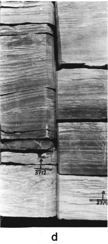
Figure 6--Photographs of the Robinson C-1 core; marks give core depths in ft. a) Interval 13--rippled beds indicating episodic deposition. b) Interval 14 (and very top of interval 13)--episodic beds of rippled sandstone (above a sharp or scoured base) grading into lenticularly bedded sandy mudstones.
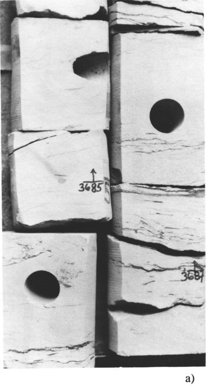
Rippled fine sandstone with silt interbeds that separate the interval into units 10-45 cm thick (fig. 6a). Uppermost parts of these intervals are finer grained than lower parts. Ripples not very obvious but are unidirectional. Uppermost part of interval is lenticular-bedded sandstone and shale with burrows.
Unit 13 can be interpreted as part of a channel sequence, perhaps lower to middle point bar in a sinuous or meandering channel. It has evidence of marine influence (the burrows) and of episodic deposition, but with episodes depositing thicker layers than did those of the lower Stalnaker, perhaps a channel in a crevasse splay.
Fining-upward sequences of rippled sand grading into burrowed lenticular-bedded mudstone and sandstone (fig. 6b). Sequences about 60 cm thick. Four whole sequences and the base of another are present.
These fining-upward sequences closely resemble the episodic beds within meandering channel sequences that express themselves as epsilon cross strata or accretion bedding of point bars. They do, however, display burrows, which imply at least brackish water during periods of low flow. Episodic unidirectional flow and burrowing suggest this interval represents farther deposition in the channel recognized in unit 13. The sequence in units 12, 13, and 14 represent progressive abandonment of a crevasse channel.
The features of the Robinson C-1 core suggest delta deposition. Lithologically distinct intervals in the core can be interpreted as results of deposition within a particular delta subenvironment. The lower and upper "Stalnaker" sands should be viewed as part of a single large system, a delta plain built by lower Stalnaker streams and marine sedimentation, followed by development of subdeltas and lobes of sediment assigned to either the lower or upper Stalnaker. The interpreted crevasse splay in the upper Stalnaker (intervals 11- 14) represents a period of progradation into an area bypassed by major delta activity while the shales of interval 10 formed.
Figure 7--Idealized delta showing possible location of environments in which core intervals accumulated; not to scale, but deltas are tens to hundreds of miles across.

The "Stalnaker" in the Robinson C-1 core has several outstanding attributes that are useful in assigning it to a depositional environment. One is the intimate interbedding of features indicating proximity of continental environment (coal, plant fragments) and those indicating marine deposition (burrows, wave-formed sedimentary structures, upward-coarsening sequences). The rocks in the core can easily be broken into intervals that represent activity of one process or a set of processes. These are marine and fluvial processes that are known to act in delta regions, by comparison with modern environments. Furthermore, the sequence in which the processes acted is consistent with a prograding delta. Other features also suggest deltaic deposition. Clearly, much of the sediment was deposited in a fashion that precluded extensive reworking by burrowers. In sandstones, this normally suggests rapid deposition, rather than toxicity of the environment. Finally, sedimentation was episodic on several scales. At the smallest scale, upward-fining, decreasing energy (scour-planebeds-ripples-lenticular bedding) packets range from a few cm to 60 cm thick. These can be grouped into overall upward-coarsening sequences up to 5 in or so thick. Repetition of these sequences suggests the environments were adjacent to each other and controlled by water depth and rate of sediment input. In those sequences, both thickness of the sand-rich part of the packets increases and that of the mudrich decreases upwards, so that mud interbeds are absent in the top of the sequence. All in all, this core suggests deposition of the Stalnaker in an area that was marginal to a marine environment, where conditions changed rapidly (both in time and laterally) but progressively, and accumulation was rapid. These conditions are best met in a delta. The environments in which the described intervals were deposited are placed on an imaginary delta in fig. 8.
Figure 8--Stratigraphic section from TXO Robinson C-1, S2 NE NE sec. 30, T. 32 S., R. 8 W., Harper County, Kansas. Measured by A. W. Walton, October 1982.
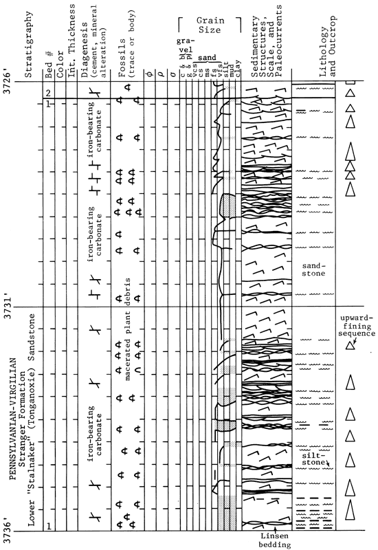
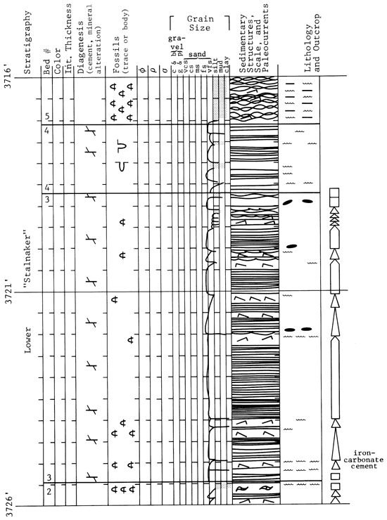
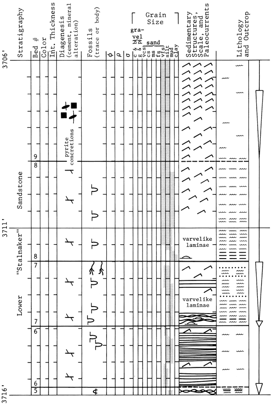
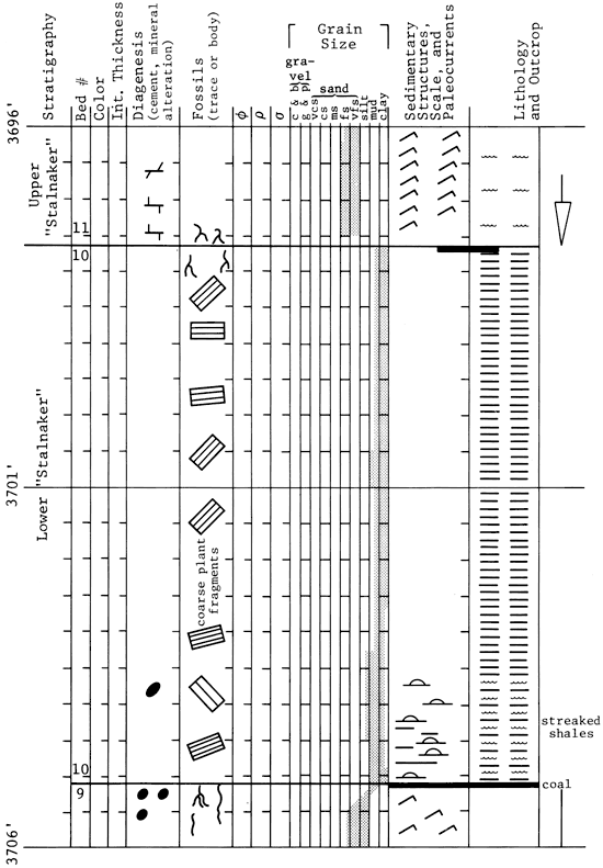
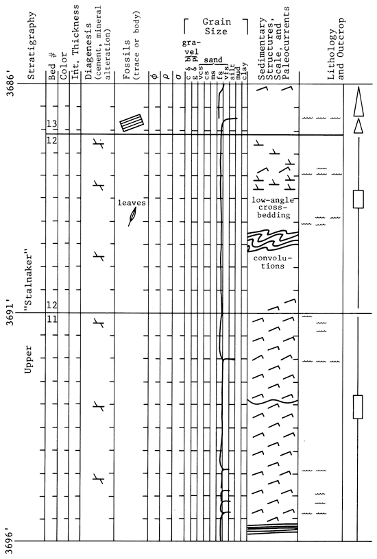
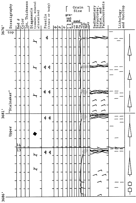
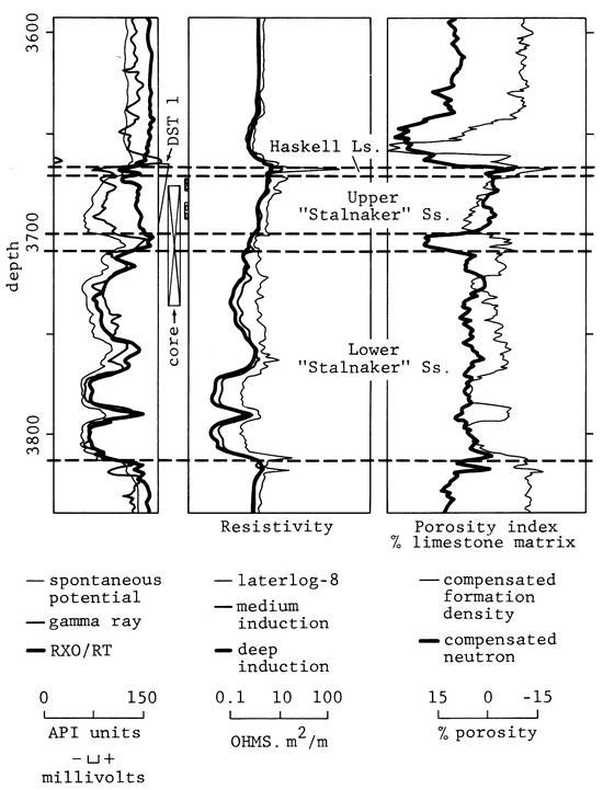
Figure 9--Spontaneous potential/gamma ray, resistivity, and porosity index log for upper and lower "Stalnaker" from TXO Robinson C-1.
Many previous workers have suggested that delta environments were important in forming terrigenous deposits in Kansas, beginning with Wanless (1963) and Wanless and others (1970). Deltaic sand bodies, especially distributary mouth bar or delta front sand bodies, have definite features that affect petroleum accumulation and production. Knowledge of reservoir sand type will guide development drilling and enhanced recovery operations. Deltaic sandstones may be more sheetlike than the fluvial shoestring sands for which eastern Kansas is so famous, but they may have thinner productive intervals. The coarsest grain size will occur at the top of the deltaic sandy units, not the bottom as in many fluvial sandstones. Diagenetic patterns and the degree of continuity of sand beds may also differ, though no one has examined these features of deltaic sandstones in Kansas.
Ball, S. M., 1964, Stratigraphy of the Douglas Group (Pennsylvanian/Virgilian) in the northern Midcontinent region: PhD. dissertation, University of Kansas.
Bass, N. W., 1929, The geology of Cowley County, Kansas: University of Kansas Quarterly, v. 7, p. 87-102.
Coleman, J. M., and Prior, D. B., 1980, Deltaic sand bodies: American Association of Petroleum Geologists, Educational Course Note Series 15.
de Raaf, J. F. M., Boersma, J. R., and Van Gelder, A., 1977, Wave-generated structures and sequences from a shallow marine succession, lower Carboniferous, County Cork, Ireland: Sedimentology, v. 24, p. 451-483.
Griffith, G. L., 1981, The Tonganoxie Sandstone in portions of Sedgwick, Butler, and Greenwood counties, Kansas: M.S. thesis, Wichita State University.
Harms, J. C., Southard, J. B., and Walker, R. G., 1982, Structures and sequences in clastic rocks: Society of Economic Paleontologists and Mineralogists, Short Course No. 9.
Lins, T. W., 1950, Origin and environment of the Tonganoxie Sandstone in northeastern Kansas: Kansas Geological Survey, Bulletin 86, pt. 5, p. 108-140. [available online]
Lukert, L. H., 1949, Subsurface cross sections from Marion County, Kansas, to Osage County, Oklahoma: American Association of Petroleum Geologists, Bulletin, v. 33, p. 131-152.
Sanders, D. T., 1959, Sandstones of the Douglas and Pedee Groups in northeastern Kansas: Kansas Geological Survey, Bulletin 134, pt. 3, p. 125-159. [available online]
Wanless, H. R., and others, 1963, Mapping sedimentary environments of Pennsylvanian cycles: Geological Society of America, Bulletin, v. 74, p. 437-486.
Wanless, H. R., and others, 1970, Late Paleozoic deltas in the central and eastern United States: Society of Economic Paleontologists and Mineralogists, Special Publication 15, p. 215-245.
Winchell, R. L., 1957, Relationship of the Lansing Group and the Tonganoxie ("Stalnaker") Sandstone in south-central Kansas: Kansas Geological Survey, Bulletin 127, pt. 4, p. 123-152. [available online]
Kansas Geological Survey
Comments to webadmin@kgs.ku.edu
Web version April 16, 2010. Original publication date 1985.
URL=http://www.kgs.ku.edu/Publications/Bulletins/Sub6/Walton/index.html