Kansas Geological Survey, Bulletin 134, part 3, originally published in 1959
Originally published in 1959 as Kansas Geological Survey Bulletin 134, part 3. This is, in general, the original text as published. The information has not been updated. An Acrobat PDF version (13 MB) is also available.
Sandstones of the Douglas and Pedee Groups (Upper Pennsylvanian) in northeastern Kansas occupy definite channel-like trends, which are interpreted as being ancient river valleys. Isolith maps of sandstones above and below the Haskell Limestone show major features of this drainage pattern and indicate that little or no sandstone is present in much of the area. The deepest channel (i.e., trend of thickest sandstone) above the Haskell Limestone trends in an irregular westerly direction across Wabaunsee, Osage, and Franklin counties, and main sandstone deposition below the Haskell Limestone was in a deep channel extending southwestward through Douglas, Franklin, Osage, Coffey, Lyon, and Greenwood counties. Sandstone as much as 160 feet thick was found in each of these stratigraphic units.
A few samples of Ireland and Tonganoxie Sandstone, the most important units in the sequence, were analyzed, and all samples were found to have similar physical characteristics. Fine to very fine sand is predominant in both sandstones, but the Ireland contains a larger percentage of silt. Subangular to angular quartz grains make up 90 to 95 percent of the volume of all samples, the remainder being composed of muscovite, some tourmaline, and rare chlorite grains. Permeability is uniformly low, although both of these sandstones are important aquifers in northeastern Kansas.
Results of this study should aid in locating new sources of ground water and possibly in developing underground storage reservoirs for surface water.
This investigation was undertaken in order to map and describe the aggregate distribution and thickness of sandstones in the Douglas and Pedee Groups, of late Pennsylvanian age, in the subsurface of northeastern Kansas, and to study their physical characteristics. It is believed that results of this study will have value in locating ground water for domestic, municipal, or industrial use.
Owing to the nature of subsurface data available in this part of Kansas, and for greater clarity in mapping, the sandstones of the Douglas-Pedee stratigraphic sequence have been arbitrarily divided into two groups, those above the Haskell Limestone member of the Stranger Formation (Pl. 1) and those below the Haskell Limestone (Pl. 2). Each of these subdivisions contains, in certain parts of the area studied, a major sandstone unit (Ireland Sandstone above and Tonganoxie Sandstone below) as well as several comparatively local sandstone phases of various shale units.
Although very few sandy zones were found in the Pedee Group, and none of these was continuous over much of the area, the Douglas and Pedee Groups were studied as a unit because of the difficulties encountered in attempting to separate them in the subsurface. In much of the area studied, their contact is one of shale upon shale, virtually impossible to recognize on well logs. Thus the only reliable stratigraphic horizons everywhere usable as upper and lower limits of the sequence studied are the base of the Oread Limestone (which overlies the Douglas Group) and the top of the Stanton Limestone (which underlies the Pedee Group).
Original plans included an investigation of only the Ireland Sandstone member of the Lawrence Formation, with the objective of mapping its distribution and thickness in northeastern Kansas and interpreting its origin and depositional environment. It soon became obvious, however, that available subsurface data were quite inadequate for such a detailed study, and that any conclusions concerning origin and environment of deposition would have little validity. It was decided, therefore, to change emphasis to a more generalized investigation of all sandstones in the Douglas and Pedee Groups.
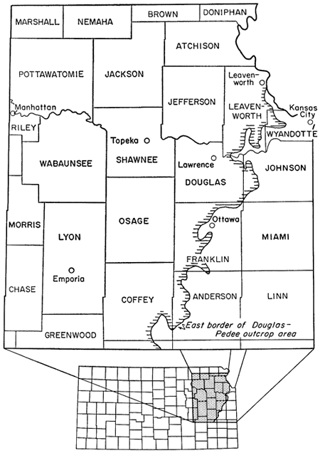
The area discussed in this report includes approximately 9,000 square miles in northeastern Kansas (Fig. 1). The northern boundary is the north side of T. 4 S., the western boundary is the west side of R. 8 E., and the southern boundary is the south side of T. 23 S. The eastern boundary is delineated by the Kansas-Missouri state line approximately as far south as the city of Leavenworth, Kansas, and by the eastern border of the Douglas-Pedee outcrop area from Leavenworth to T. 23 S., R. 16 E.
Figure 1--Index map showing location of area discussed in this report.
During October and November of 1956, selected sections of rocks in the Douglas and Pedee Groups were measured and samples of Ireland and Tonganoxie sandstone were taken for laboratory analysis. Locations from which samples were obtained, although few, were chosen in an attempt to obtain representative specimens with regard to both lateral variation and stratigraphic position. The samples selected for analysis were divided into two parts, one for permeability tests and the other for size analysis and microscopic examination.
Subsurface data were obtained by the examination of logs of somewhat more than 1,000 oil wells and water wells in the area studied. All logs used are in the files of the State Geological Survey of Kansas. Where drilling has been relatively intense, as in northern Greenwood County, many logs were eliminated, and only those believed to be reliable were used. In areas of little drilling activity, where too much selectivity would have led to almost complete lack of control, only the obviously poor logs were omitted. Well samples were studied as an aid to interpretation of logs from some of the more problematical areas.
Electric logs or, to a lesser degree, radioactivity logs, were judged to be most reliable and were used wherever available. Logs of the Kansas Sample Log Service, plotted on the basis of sample analysis, were used where possible in preference to drillers logs, which were relied upon only where more dependable types were not accessible.
Literature on the Pennsylvanian rocks of Kansas is extensive; many of the sandstones in the Pennsylvanian and Permian sections have been studied (Bass, 1934, 1936; Cadman, 1927; Charles, 1927; Cheney, 1929; Mudge, 1956; Pierce and Courtier, 1935; Rich, 1923, 1926; Rubey and Bass, 1925; Tarr, 1934). Environmental significance of the sandstones, in Kansas and elsewhere, and their relation to cyclical deposition, have been discussed by Moore (1929, 1931, 1950), Reger (1931), Stout (1931), Wanless (1931), Wanless and Shepard (1936), Weller (1930, 1931), and others.
Patterson (1933) described the Douglas Group as it crops out in Douglas and Leavenworth counties, Kansas. Rich (1933), after studying coal fragments found in the base of the Ireland Sandstone in northwestern Franklin County, estimated that a time span of "some millions of years" is represented by the pre-Ireland disconformity. Bowsher and Jewett (1943), in describing coal resources of the Douglas Group in northeastern Kansas, discussed stratigraphic relations of the coal beds. Lins (1950), from a study of outcrops in northeastern Kansas, concluded that the Tonganoxie Sandstone was deposited in the valley of a large southwestward-flowing river.
Strata of the Douglas and Pedee Groups have been described in several publications of the State Geological Survey of Kansas and other organizations, but until now no attempt has been made to map their regional distribution and thickness in this part of the state.
I wish to express my thanks to Dr. H. A. Ireland of the Department of Geology, University of Kansas, who supervised this study and made many helpful suggestions and criticisms. Mr. Wallace Lee gave advice on interpretation of well logs and preparation of the structure contour map. Mr. Floyd W. Preston and Mr. Kevin R. Jones, of the Department of Petroleum Engineering, University of Kansas, made available the equipment in the petroleum engineering laboratory. Part of the drafting was done by Miss Marilyn Eaton. Mr. George DeVries Klein made sieve and pipette analyses of a sample of Ireland Sandstone.
Rocks belonging to the Pedee and Douglas Groups (Fig. 2) are late Missourian and early Virgilian in age, respectively, the boundary between the two series being placed at the unconformity below the basal sandstone (Tonganoxie) of the Douglas Group (Moore, 1932, p, 88). The following description of these strata, presented in ascending order, is taken mostly from Moore (1949) and Moore and others (1951). Minor modifications applicable to the area studied, as observed in well logs and at the outcrop, have been added. Included in the description, for reference, are the Stanton and Oread Limestones, which respectively underlie and overlie the Douglas-Pedee sequence.
Figure 2--Generalized stratigraphic section (adapted from Moore and others, 1951).
Stanton Limestone
The Stanton Limestone, which directly underlies Douglas-Pedee strata, contains three limestone and two shale members. The upper member, South Bend Limestone, is easily distinguishable on electric well logs and serves as a good subsurface marker bed. On most drillers logs the whole formation is denoted as limestone, making its top readily apparent. Although the formation ranges in thickness from 10 to 90 feet throughout its area of outcrop, it was found to be consistently about 50 feet thick in the area of this investigation.
Captain Creek Limestone member--The Captain Creek Limestone is massive or even-bedded, granular to dense, and dark gray to bluish gray. Common fossils are the brachiopod Enteletes pugnoides and the fusulinid Triticites neglectus. The member is characteristically about 5 feet thick along Kansas River, and in the area studied, as indicated on electric logs, thickness of the member ranges from 5 feet to 15 feet in the south. Acording to Lins (1950, p. 112), the pre-Tonganoxie erosion surface in places cuts down as low as the Captain Creek Limestone, but this relationship was not observed during the present study. The oldest unit seen to be directly overlain by the Tonganoxie Sandstone in the subsurface is the Stoner Limestone member of the Stanton Limestone (Fig. 2).
Eudora Shale member--The Eudora Shale is dark gray to black and fissile in the lower part, clayey and greenish to bluish gray in the upper part. It contains few megascopic fossils in this part of Kansas. In the subsurface this member was found to maintain a thickness of 5 to 10 feet.
Stoner Limestone member--The Stoner Limestone is composed of thin, wavy beds mostly separated by thin shale partings. It is fine grained and light bluish gray to nearly white. Fossils are not common generally, but in northern exposures Triticites are abundant. Typically this is the thickest member of the Stanton Limestone, ranging from about 20 to 30 feet throughout the area of study. Tonganoxie Sandstone (Fig. 2) rests on the Stoner Limestone where pre-Tonganoxie erosion in this area has cut most deeply into older strata.
Rock Lake Shale member--The Rock Lake Shale is mostly reddish to yellowish brown, but greenish-gray clay shale is common in the lower part. The upper part tends to be sandy, and locally is represented by massive sandstone. Both marine and non-marine fossils are present. Thickness of the Rock Lake Shale ranges from 5 to 15 feet throughout the area, increasing somewhat in places where the sandstone occurs. In areas of deep pre-Tonganoxie erosion this member may be absent.
South Bend Limestone member--The top of the South Bend Limestone represents the lower limit of the Douglas-Pedee stratigraphic sequence (Fig. 2). The South Bend member is composed of dark-gray fine-grained limestone, but contains sandy limestone and, locally, sandy shale at the base. Common fossils include fusulinids and the brachiopod Meekella. The thickness is consistently about 5 feet, although in parts of the area where pre-Tonganoxie erosion was comparatively deep the limestone has been partly or completely removed. In such places the base of the Tonganoxie Sandstone serves as the lower boundary of the Douglas-Pedee sequence, although where this occurs the entire Pedee Group has been removed by the same erosion.
The Pedee Group, comprising the Weston Shale and Iatan Limestone, is the lower of the two groups with which this report is concerned. Over much of the area studied it was partly or wholly removed during the time of emergence and erosion that preceded deposition of the lower sandstone member (Tonganoxie) of the overlying Douglas Group. Where present, the Pedee Group conformably overlies the Stanton Limestone and, as shown by its relation to the Tonganoxie Sandstone, disconformably underlies rocks of the Douglas Group (Fig. 2). Its thickness has a large range, owing to this same disconformity. Maximum thickness is almost indeterminate in the subsurface, even where the basal sandstone of the Douglas Group is absent, because the upper formation (Iatan Limestone) of the Pedee Group either was not deposited in much of the area or does not show up clearly on well logs. Those logs showing a limestone that is probably the Iatan indicate an average thickness of approximately 60 feet for the group in this area. Moore and others (1951, p. 78) give 90 feet as the average thickness in outcrops, and Moore (1949, p. 120) also states that exposures of as much as 200 feet have been observed in southern Kansas.
Weston Shale
Weston Shale is the name given the lower and thicker formation of the Pedee Group. It is mostly dark-blue to bluish-gray clay shale, and locally contains thin fossiliferous limestone beds. Also present, especially toward the south, are some beds of shaly and even-bedded sandstone. Some well logs examined indicate a sandstone body, in most places not more than 20 feet thick, near the base of the formation, but no definite pattern of occurrence is discernible. Limonitic concretions are characteristic of the Weston Shale in many outcrops, and marine fossils have been found in places. Where the formation has not been subjected to post-Pedee erosion it may attain a thickness of nearly 200 feet, but the greatest thickness noted with certainty in the subsurface is approximately 45 feet.
Iatan Limestone
The Iatan Limestone, at the top of the Pedee Group, seems to be discontinuous over much of the area included in this investigation. In many places where it probably is present, it has not been definitely indicated on well logs. Where the Iatan is absent the Weston Shale is disconformably overlain by sandstone or shale of the lower Douglas Group. The Iatan Limestone is light bluish gray to white, and very fine grained to dense. It has a massive appearance, owing to indistinctness of bedding planes. Although not abundantly fossiliferous, the formation locally contains fusulinids, brachiopods, bryozoans, crinoid fragments, and small corals. Where the Iatan Limestone is present its thickness ranges from about 4 to 22 feet.
The Douglas Group, upper of the two groups that are the subject of this report, disconformably overlies rocks of the Pedee Group. It is conformably overlain by the Oread Limestone of the Shawnee Group, except possibly in southern Douglas County (Moore and others, 1951, p. 69). The disconformity at the base of the Douglas Group forms the Missourian-Virgilian boundary in Kansas as defined by Moore (1932, p. 88). Rocks of this group are mostly shale and sandstone, but relatively minor beds of limestone, coal, and conglomerate are included.
Total thickness of the Douglas Group has considerable range and is determined over most of the area by the depth to which post-Pedee erosion has cut into older strata (Fig. 2). Where the basal Tonganoxie Sandstone member was not deposited, determination of thickness of the Douglas Group in the subsurface is extremely difficult. On the basis of what reliable information is available from subsurface data, its average thickness in this area is probably about 180 feet. Maximum thickness, where the most extensive deposits of Tonganoxie Sandstone occur, is about 340 feet. Moore (1949, p. 127) states that "the thickness of the group ranges from about 50 feet in southeastern Nebraska to nearly 700 feet in southern Kansas." The combined thickness of the Douglas and Pedee Groups in the area investigated was seen to increase more or less regularly from about 100 feet in southeastern Marshall County to about 340 feet in southern Coffey County and northwestern Franklin County, indicating a general thickening of the clastic deposits of these groups toward the southeast.
The Douglas Group includes the Stranger Formation below and the Lawrence Shale above.
Stranger Formation
The Stranger Formation comprises one sandstone member, two shales members, and two comparatively thin limestone members. The middle member (Vinland Shale) is generally sandy and locally grades into a massive sandstone of appreciable thickness, which lies disconformably on older rocks. The base of the Stranger Formation is marked by the disconformity below the Tonganoxie Sandstone member. The top of the formation, too, is defined by a disconformity, this one produced by post-Stranger erosion after which a sandstone (Ireland) similar in character to the Tonganoxie Sandstone was widely deposited (Fig. 2). Because in much of the area these disconformities cut deeply into underlying strata, though not necessarily in the same localities, the thickness of the Stranger Formation differs greatly from place to place. Where the post-Stranger erosion is not deep and where pre-Stranger erosion has allowed Tonganoxie Sandstone to occupy the stratigraphic position of older rocks, the thickness of the Stranger Formation may exceed 200 feet. Because the presence of Ireland Sandstone is necessary for recognition of the top of the Stranger Formation on well logs, and because the Ireland Sandstone was deposited on the eroded surface of Stranger beds, the actual maximum thickness of the Stranger Formation in the subsurface can only be estimated. The Stranger Formation is absent in the few areas where post-Stranger erosion has cut into strata of the underlying Pedee Group, as in southeastern Douglas County.
Tonganoxie Sandstone member--The Tonganoxie constitutes most of the sandstone below the Haskell Limestone in the Douglas-Pedee deposits (Plate 2), and its lithologic characteristics will be discussed in detail in a later section of this report. Generally, this member is made up of massive crossbedded sandstone or (less typically) thin-bedded shaley sandstone, and sandy to clayey shale; it includes several thin and discontinuous coal beds in the upper part. The sandstone is fine grained and light brown or tan at the outcrop and light gray in well samples; the shale (Lins, 1950, p. 124) is either silty and light brown to reddish brown, or clayey and light bluish gray to dark blue. The two most persistent coal beds have been named Upper and Lower Sibley. In some outcrops the basal portion of the member is made up of a conglomerate composed mostly of small limestone pebbles, quartz sand, silt, and limonite or clay cement. Plant remains are present in the sandstone and conglomerate.
In northeastern Kansas thickness of the Tonganoxie, where post-Stranger erosion has not cut into the member, may attain 160 feet, depending on relief of the pre-Tonganoxie erosion surface upon which the sandstone was deposited.
Westphalia Limestone member--The Westphalia, although not definitely recognized north of T. 19 S. (Moore and others, 1951, p. 73), has been tentatively identified farther north by Lins (1950, p. 115) as "a carbonaceous laminated dark blue limestone," which occurs 3 to 4 inches above the Upper Sibley coal. In southern exposures it is characterized by the presence of fusulinids. Like the Iatan Limestone of the Pedee Group, it can be identified on very few well logs, and is assumed to be discontinuous over most of the region studied. Maximum thickness of the limestone recognized by Lins is only 1 foot and the member has been completely removed in areas where post-Stranger erosion was most extensive.
Vinland Shale member--The Vinland is gray, clayey, calcareous, and sandy, and locally grades into massive light-brown to tan sandstone of considerable thickness. In areas where this sandstone attains maximum development, the base of the member is marked by a slight disconformity. Marine fossils are abundant in most outcrops, a characteristic zone near the top containing many remains of clams (Myalina). Thickness of the Vinland Shale, where it has not been removed by post-Stranger erosion as in southeastern Douglas County and northwestern Franklin County, is probably as much as 50 feet in this area. An exact figure is difficult to establish from subsurface data because of the discontinuous nature of the underlying Westphalia Limestone.
Haskell Limestone member--The Haskell is bluish gray and fine grained and is a single massive bed in most outcrops. Fossils include algae, fusulinids, and brachiopods. Where not removed by post-Stranger erosion, the member attains a thickness of 10 feet. It is extremely persistent throughout northeastern Kansas and is easily recognizable on most well logs. It occurs approximately in the middle of the Douglas-Pedee sequence and between the two major sandstone bodies (Fig. 2). For these reasons it was chosen as the dividing marker between the groups of sandstones mapped on Plates 1 and 2.
Robbins Shale member--The Robbins Shale, which conformably overlies the Haskell Limestone and disconformably underlies the Lawrence Shale, is gray to yellowish gray and in many places includes a zone of phosphatic concretions near the base. Many of these concretions contain ammonoid cephalopods and casts of fish brains. Because of the disconformity above this member, it is absent where the erosion has cut into older strata, but is as much as 100 feet thick in southern Kansas. The thickness of the Robbins Shale in the subsurface is difficult to determine where the overlying sandstone is not present, because the contact then becomes one of shale upon shale.
Lawrence Shale
The Lawrence Shale is the uppermost formation included in the present study. It is composed predominantly of blue-gray and yellowish shale and tan to light-brown fine-grained sandstone, but contains comparatively thin limestone and coal beds in some areas. A basal conglomerate can be seen in some outcrops. The Ireland Sandstone member is widespread and grades upward from sandstone at the base of the formation into thin-bedded shaly sandstone or sandy shale. Above this in parts of northeastern Kansas, although most readily recognizable farther south, is the Amazonia Limestone member. The Amazonia Limestone or equivalent zone is overlain by a sequence of tan to greenish-gray clayey or sandy shale, which in some localities grades laterally into massive, fine-grained, tan to light-brown sandstone. Locally this shale-sandstone sequence becomes fairly thick and may, as indicated on logs of wells in parts of southern Pottawatomie County, extend from the base of the Oread Formation to a horizon well below the zone of the Amazonia Limestone. Also present in the upper part of the Lawrence Shale in most outcrops are thin coal beds (chiefly the Upper and Lower Williamsburg coals) and a characteristic layer of maroon clay shale.
Thickness of the Lawrence Shale, like that of the Stranger Formation, is dependent upon the downward extent of erosion responsible for the disconformity at its base. The greatest thickness observed during the study is approximately 170 feet. Where the Ireland Sandstone member is missing or very thin, the Lawrence Shale may have a thickness of only 40 feet. The exact position of its base is indeterminable on well logs that do not show Ireland Sandstone and also in places where the Ireland members rests on Tonganoxie Sandstone; hence in may parts of the area an accurate determination of its thickness is impossible.
Ireland Sandstone member--Inasmuch as the Ireland Sandstone is the most important sand body of the Douglas Group occurring above the Haskell Limestone (Plate 1), its lithologic characteristics are discussed in detail in a later section of this report. Only general features are presented here. The member rests disconformably on various strata of the Stranger Formation or, locally, where post-Stranger erosion was deepest, as in southeastern Douglas County and northwestern Franklin County, it is in contact with rocks of the Pedee Group (Fig. 2). The Ireland and Tonganoxie sandstones look identical in outcrops and in most places can be distinguished only by stratigraphic position. Like the Tonganoxie Sandstone, the Ireland is composed of fine-grained light-brown or tan massive sandstone, mostly crossbedded, which grades both vertically and laterally into thin-bedded silty or shaly sandstone. In places a limy conglomerate occurs at the base. Plant remains have been found in the thin-bedded material, and the basal conglomerate may contain coal fragments. Thickness of the Ireland Sandstone is as much as 160 feet in parts of the area investigated. Owing to the indistinct nature of the upper part of the member and the disconformity at its base, an exact figure is difficult to detemine.
Amazonia Limestone member--The Amazonia Limestone, which lies 25 to 30 feet below the Oread Limestone, is typically light gray, hard, and dense. Like the Iatan and Westphalia Limestones previously described, it is discontinuous in northeastern Kansas and shows up poorly on well logs. Where recognized in this part of the state, it is, in most exposures, a coquinoidal, fragmental bed of reddish brown tinge. It is not normally fossiliferous, but several kinds of marine fossils have been found locally. The Amazonia member is as much as 13 feet thick in outcrops, gradually thinning to a featheredge in southern Kansas. Where recognizable on well logs its average thickness is somewhat less than 10 feet.
Oread Limestone
The base of the Oread Limestone marks the upper limit of the Douglas Group (Fig. 2). The formation contains four limestone and three shale members. Its lowest member, the Toronto Limestone, although not present locally, can be recognized easily on most electric logs and serves as a good subsurface datum. The formation is recorded on almost all drillers logs and can be correlated easily. Its thickness ranges from 45 feet in the type area at Lawrence, Kansas, to about 100 feet in southern Kansas, the increase being due mainly to southward thickening of the Snyderville Shale member. In the area studied, the Oread Limestone ranges in thickness from about 40 feet in the north to about 80 feet in the south.
Toronto Limestone member--The Toronto Limestone is massive and brownish gray, weathering to a characteristic deep brown. Common fossils are fusulinids, corals, and small brachiopods. In the outcrop area it is locally absent in southern Douglas County and elsewhere and is indistinct in part of southern Kansas. In the subsurface, too, it seemingly is missing in small parts of the area investigated, though in general it has wide continuity. Thickness of the Toronto in northern Kansas ranges from 8 to 12 feet, and in the area studied it averages about 10 feet.
Snyderville Shale member--In northern Kansas the Snyderville is mostly structureless gray to bluish-gray clay, but there is some red shale. In southern Kansas the member is sandy and in places contains sandstone and impure limestone. Marine fossils, especially the brachiopod Chonetes, are found in the unit. Its thickness increases greatly toward the south, from an average of 12 feet in the north to about 75 feet in southern Kansas. In the area studied it was found to range from about 5 to 20 feet. In places where the Toronto is absent, Snyderville Shale will be found in contact with Lawrence Shale.
Leavenworth Limestone member--The Leavenworth Limestone occurs as a dark bluish-gray, dense, massive bed having a uniform thickness between 1 and 2 feet. It commonly contains fusulinids and brachiopods. Owing to its relative thinness, it is not easily recognizable on many electric well logs, and is indicated on only an occasional drillers log.
Heebner Shale member--The Heebner, although mostly black platy shale, also includes calcareous clay and dark bluish-gray shale near the top and some gray or yellow clay shale at the bottom. Small brachiopods are found near the top, and the black shale contains conodonts. Abundant gastropods can be found locally in the basal yellow shale. Thickness of the Heebner Shale is consistently 5 to 7 feet. It forms an excellent subsurface datum because the black shale is easily recognized in samples and makes a distinctive "kick" on electric logs and especially on radioactivity logs.
Plattsmouth Limestone member--The Plattsmouth member is composed of light-bluish-gray, dense, wavy-bedded limestone. Common fossils are fusulinids, corals, bryozoans, brachiopods, and some mollusks. Chert nodules are characteristic of the member in northern outcrops. In most places it is the thickest member of the Oread Limestone, averaging approximately 20 feet thick in northeastern Kansas, but thinning southward.
Heumader Shale member--The Heumader Shale is mostly dark gray but in places is bluish or greenish gray. It is clayey to silty, becoming sandy in southern Kansas. Marine fossils, especially mollusks, are common. Its thickness is generally less than 5 feet.
Kereford Limestone member--The Kereford Limestone is widespread in northeastern Kansas but is not recognized in the southern part of the state. Its lithology is not everywhere the same, in places being oölitic or fine grained and flaggy and elsewhere massive and dense. Locally it is shaly. Its color is generally dark bluish gray. Fossils include algae, fusulinids, other marine invertebrates, and locally, remains of land plants. Where present it may be as much as 40 feet thick. The member is not definitely discernible on many well logs, seeming to merge into the Plattsmouth Limestone because of the thinness of the intervening Heumader Shale member.
Data on texture, composition, and permeability of the Ireland and Tonganoxie Sandstones were obtained from seven outcrop samples and one well sample. Although not enough samples were analyzed to warrant definite conclusions, it was felt that useful information could be derived from results of this preliminary laboratory work. Size analyses were made by the standard methods outlined in Krumbein and Pettijohn (1938) and Twenhofel and Tyler (1941). Composition was determined by examination of disaggregated samples under the binocular microscope. Permeability was measured by means of a variable-head discharging water permeameter (Fishel, in Wenzel, 1942, p. 59-63) and, for comparison of results, an air permeameter.
The localities from which samples of Ireland Sandstone were obtained for analysis are plotted on Plate 1, and the location numbers there correspond to the sample numbers used in Figure 3. Similarly, localities from which samples of Tonganoxie Sandstone were obtained are indicated on Plate 2, location numbers corresponding to sample numbers in Figure 4. Table 1 shows exact position of these localities, listed by section, township, and range.
Table 1--Location of sample-collection localities.
| Sample number |
Location | County |
|---|---|---|
| 1 | SW SW NE sec. 33, T. 8 S., R. 22 E. | Leavenworth |
| 2 | Cen NL NE sec. 36, T. 10 S., R. 22 E. | Leavenworth |
| 3 | SE NE NE sec. 14, T. 13 S., R. 20 E. | Douglas |
| 4 | SW SW sec. 27, T. 13 S., R. 19 E. | Douglas |
| 5 | Cen EL NW sec. 3, T. 15 S., R. 19 E. | Douglas |
| 6 | SE SE NW sec. 11, T. 17 S., R. 18 E. | Franklin |
| 7 | SW NE SW sec. 14, T. 17 S., R. 19 E. | Franklin |
Texture and Composition
In general aspect the Ireland and Tonganoxie sandstones are similar, and in outcrops, except possibly for minor local differences, they seem to be identical. Both are predominantly fine to very fine, and they have essentially the same composition. The few analyses made for this report show some differences in physical characteristics that may be significant, but detailed study of many samples will be necessary to establish their validity for correlation.
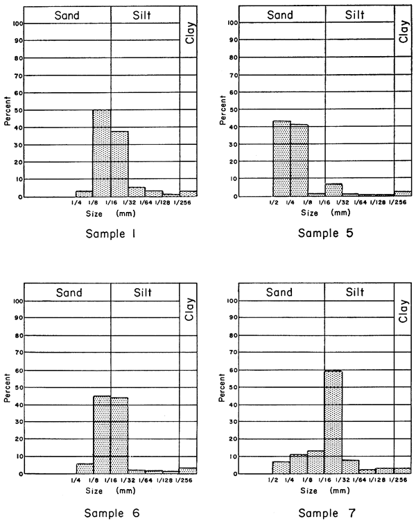
The predominant size grade of particles of Ireland and Tonganoxie sandstone varies, as would be expected, according to where the samples were obtained in relation to maximum amount of sand deposition. Samples of thin-bedded or shaly sandstone from channel borders are mostly very fine sand or silt, whereas those taken from massive, crossbedded exposures within the deeper channel trends contain a large percentage of fine or even medium sand (Fig. 3, 4; Table 2).
Table 2--Wentworth's size classification (after Krumbein and Sloss, 1951, p. 71).
| Grain diameter (mm) | Size grade |
|---|---|
| 4-2 | Granule |
| 2-1 | Very coarse sand |
| 1-1/2 | Coarse sand |
| 1/2-1/4 | Medium sand |
| 1/4-1/8 | Fine sand |
| 1/8-1/16 | Very fine sand |
| 1/16-1/32 | Coarse silt |
| 1/32-1/64 | Medium silt |
| 1/64-1/128 | Fine silt |
| 1/128-1/256 | Very fine silt |
| Less than 1/256 | Clay |
In Figure 3 it is seen that 50 percent of Sample 1, from northern Leavenworth County where the lower part of the Lawrence Shale is composed of thin-bedded, shaly sandstone, falls within the 1/8 to 1/16 mm grade (very fine sand) and that most of the remainder is coarse silt. On the other hand Sample 5, from an exposure of massive channel sandstone in southern Douglas County, is much coarser, being made up almost entirely of medium and fine sand. Sample 6, from an outcrop of massive channel sandstone in western Franklin County, is in contrast to Sample 5. The histogram of Sample 6 shows a size distribution much like that of Sample 1, and would seem to indicate that Sample 6 represents a lens of very fine sand and coarse silt within the main channel deposit. Sample 7, which is predominantly silt, came from very thinly laminated and even-bedded sandstone at an exposure on U. S. Highway 50 about 1 mile south of Ottawa, Franklin County.
Figure 3--Histograms showing size analyses of samples of Ireland Sandstone.
Samples 2A and 2B, histograms of which are shown in Figure 4, were obtained from an outcrop in sec. 36, T. 10 S., R. 22 E., in eastern Leavenworth County (Plate 2). Lins (1950, p. 129), in discussing this outcrop, has suggested the presence here of both Ireland and Tonganoxie sandstones separated by a pebble conglomerate, which cuts across the exposure. Sample 2A was collected from a point 4 feet above this conglomerate, and Sample 2B from a point 2.5 feet below it. The presence of both sandstones in this locality is improbable, however, for Plate 1 shows that little or no Ireland Sandstone is present in the subsurface of western Leavenworth County, and no major Ireland channel is trending toward the area where Samples 2A and 2B were collected. On the other hand, this locality is well within the projected trend of main Tonganoxie deposition, which is discussed below. Further, the histogram of Sample 2A (which, if Lins were correct, would be Ireland Sandstone) is similar to other histograms of Tonganoxie Sandstone in Figure 4 and is dissimilar to histograms of Ireland Sandstone in Figure 3.
Figure 4--Histograms showing size analyses of samples of Tonganoxie Sandstone.
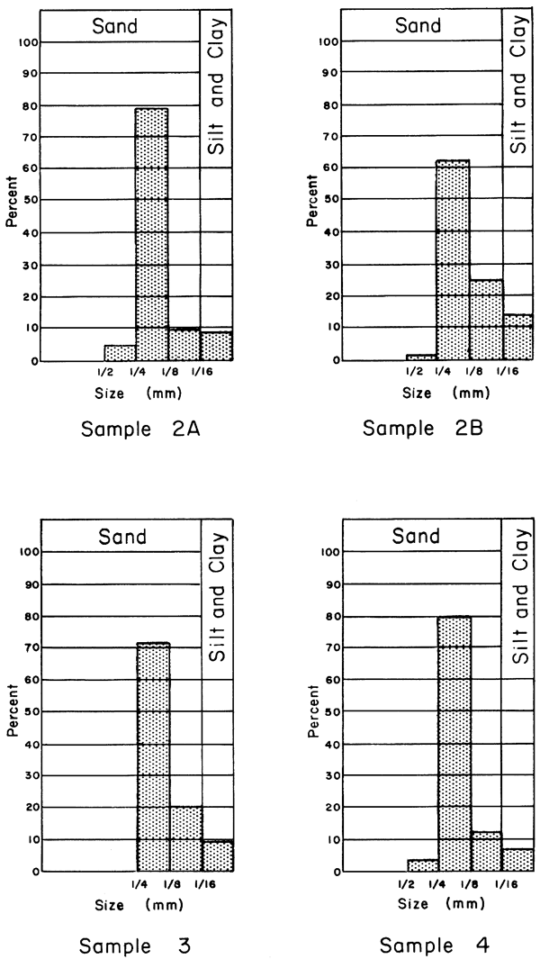
Sample 3 was collected from an exposure of massive Tonganoxie channel sandstone, which can be seen along Wakarusa River in sec. 14, T. 13 S., R. 20 E., Douglas County. It contains virtually no sand grains greater than 1/4 mm in diameter, although the 1/4 to 1/8 mm grade (fine sand) constitutes more than 70 percent of the sample. Sample 4 is a well sample from sec. 27, T. 13 S., R. 19 E., also within the main channel trend, and has a size distribution almost identical to that of Sample 2A. Both of these samples are extremely well sorted, having almost 80 percent of total volume in the 1/4 to 1/8 mm size range.
In comparing Figures 3 and 4 it is seen that with the exception of Sample 7, analyses of Ireland Sandstone indicate that it is less well sorted than Tonganoxie Sandstone. All four samples of Tonganoxie Sandstone contain much more fine sand (1/4 to 1/8 mm) than other size grades, and all contain comparatively little silt and clay. Their average silt and clay content is only about 9 percent, too little to warrant pipette analysis after sieving, whereas all samples of Ireland Sandstone contain a large percentage of particles in this category. All samples of Tonganoxie Sandstone were obtained from massive, crossbedded layers within main channel trends, whereas two Ireland samples came from thin-bedded or shaly rock.
All samples analyzed were found to have essentially the same overall composition. It is estimated that subangular to angular quartz grains account for 90 to 95 percent of the volume of all size grades of each sample. Some rounded and frosted grains were observed in the larger sizes (greater than 1/4 mm in diameter). The remaining 5 to 10 percent is predominantly thin flakes of muscovite, but includes a few irregular crystals of tourmaline and, rarely, amorphous chlorite grains. The only significant variation observed, both from sample to sample and between size grades of the same sample, is in relative quantity of muscovite. In contrast to Ireland Sandstone specimens, in which most muscovite is 1/4 to 1/8 mm in diameter, the greatest distribution of this mineral in Tonganoxie Sandstone seems to be in the 1/8 to 1/16 mm range. This cannot be regarded as a definite conclusion, however, for only four samples of each member were analyzed, and in Sample 2B (Tonganoxie) the greatest precentage of muscovite was found in the 1/2 to 1/4 mm grade. It was noted that more muscovite is present in samples of thin-bedded, silty sandstone than in samples of massive, crossbedded sandstone from main channel areas. This corroborates an observation made by Lins (1950, p. 121), with regard to Tonganoxie Sandstone, that "as the proportion of larger size sand grains increases, the amount of muscovite decreases; and, conversely, as the proportion of larger size sand grains decreases, the amount of muscovite increases."
Cement is predominantly clay or limonite in outcrops, where it coats the quartz grains and imparts a brownish color to the rock. Subsurface samples, however, are light gray to ahnost white and they react readily with hydrochloric acid, showing the presence of calcium carbonate cement. Ireland Sandstone in surface exposures may contain slightly more iron, as stated by Lins (1950, p. 129), which would account for its somewhat darker color in some outcrops. This difference is not recognized everywhere, however, and can be used only locally.
Permeability
Table 3 gives the coefficient of permeability in meinzer units of four samples each of Ireland and Tonganoxie sandstone that were collected from the same outcrops as the samples discussed in the preceding section. Results with the air permeameter were obtained by measuring the time required for a known quantity of air, at known pressure, to pass through a small core of sandstone. Two cores were cut from each sample, one parallel to the bedding and one perpendicular. Results with the variable-head water permeameter were obtained by measuring the time required for a given quantity of water to drain through a cylinder filled with disaggregated sand.
Table 3--Coefficients of permeability (meinzer units) of samples of Ireland and Tonganoxie Sandstone.
| Sandstone member |
Sample number |
Air method | Water method |
|
|---|---|---|---|---|
| Parallel to bedding |
Perpendicular to bedding |
|||
| Ireland | 1 | * | * | 24 |
| 5 | 65 | 53 | 73 | |
| 6 | 120 | 107 | 132 | |
| 7 | 3 | * | * | |
| Tonganoxie | 2A | 103 | 53 | 149 |
| 2B | 54 | 29 | 57 | |
| 3 | 147 | 58 | 47 | |
| 4 | * | * | 31 | |
| *No sample, or sample unsuitable for testing. | ||||
Even though tests with the water permeameter and air permeameter were made with disturbed and undisturbed samples, respectively, the results correspond closely. Note that values obtained with disturbed samples in the water permeameter are in most cases similar to those obtained in the air permeameter from cores cut parallel to stratification. As would be expected, cores cut parallel to the bedding are more permeable than those cut perpendicular to the bedding.
The coefficient of permeability, like predominant size grade, seems to depend upon where samples were obtained with respect to main channel deposition. Samples 1 and 7, both very silty and thin bedded and collected from localities marginal to main depositional trends, have extremely low coefficients of permeability. In comparison, Samples 5 and 6 (Ireland Sandstone) and 2A, 2B, and 3 (Tonganoxie Sandstone), all composed of massive, crossbedded sandstone from main channels, are much more permeable. Sample 4 seems anomalous in this respect, in that it was obtained from a well that penetrates the main Tonganoxie channel. No cores were available for analysis with the air permeameter, however, and it is possible that false readings were obtained with the water permeameter.
The values given in Table 3 are the same order of magnitude as coefficients of permeability obtained by means of pumping tests of wells that get water from Douglas sandstones in northeastern Kansas. Such tests have given results ranging from 50 to 300 meinzer units (H. G. O'Connor, personal communication). Although these values are low compared to many aquifers (e.g., Pleistocene gravels in this area may have permeability coefficients of 6,000 or more), the sands yield adequate supplies for domestic, stock, or small town wells.
Sandstone is not everywhere present in the Douglas and Pedee Groups. Plates 1 and 2 show that the sand bodies occur in several broad trends of diverse orientation and there is little or no sand in large areas between these trends, which are judged to be ancient river channels filled with sand before deposition of overlying strata. Knowledge of the location and thickness of these channel deposits is, of course, of utmost importance in any a.ttempt to use the Douglas-Pedee sandstones as sources of ground water.
It should be emphasized that areas of sand shown on Plates 1 and 2 do not necessarily represent, in any given locality, the existence of a single sand body. Because of the nature of the sandstones themselves, which may grade either laterally or vertically into shale, and the inadequacy of subsurface data for detailed correlation, only net sand thickness was mapped. For example, an isolith (i.e., equal lithology) value of 50 feet on the map may theoretically indicate the presence of one 50-foot sandstone bed, five 10-foot beds, or any other combination resulting in an aggregate sand thickness of 50 feet, the thickness of any intervening strata of different lithology being ignored. In practice, however, the isolith values shown on Plates 1 and 2 are controlled chiefly by the presence or absence of Ireland or Tonganoxie Sandstone, respectively, so that at least one major sandstone unit can be expected wherever a thickness of more than 20 feet is indicated on the maps. (For details of the contruction of isolith maps, see Low, in LeRoy, 1950, p. 941-951.)
Sandstones Above Haskell Limestone
Two main sandstones have been recognized in the Douglas Group above the Haskell Limestone. The most important of these, with regard to both thickness and areal extent, is the Ireland Sandstone member of the Lawrence Shale. The other is an unnamed sandstone that occurs locally above the Amazonia Limestone member. Aggregate thickness and distribution of these sandstones, along with other sand lenses above the Haskell Limestone, are shown on Plate 1. Ireland Sandstone deposition is assumed to account for at least the trends of greatest sand thickness as indicated on the map. Supporting this assumption is the observation that in northwestern Franklin County, where isolith values are especially large, Ireland Sandstone is very thick and massive in outcrops (Laughlin, 1957, p. 17, Fig. 6A, and Pl. 1).
Plate 1 shows that sandstones above the Haskell Limestone occur in two main trends, or channels, and in subsidiary channels in several places. The deepest channel (i.e., the trend of greatest sandstone deposition) follows an irregular, predominantly westward course across the center of the area. The maximum thickness is shown to be slightly more than 100 feet throughout its length, although in areas where control is poor, as in eastern Wabaunsee County, it may be either more or less. Extrapolation of the 100-foot isolith line through these areas is felt to be justified, however, because in both western Wabaunsee County and southeastern Osage County, wells have penetrated 100 feet or more of sandstone, and they are located in such a way as to indicate continuation of the trend through the intervening area. Further, on each side of this extrapolated channel, well logs indicate a definite thickening of sand deposits toward the area outlined by the 100-foot isolith line.
The other main channel is formed by the union of two smaller ones in northern Jackson County and extreme southeastern Nemaha County. This trend then continues southwestward across Jackson County into Wabaunsee County, where it joins the deeper channel. This second channel is neither as wide nor as deep as the first one, although a well in T. 8 S., R. 14 E., penetrated 90 feet of sandstone.
In southern Douglas County and northwestern Franklin County the existence of a very thick sandstone section is indicated by subsurface data and confirmed by surface exposures. The relation of this deposit to the main channel, which seemingly is farther south, is obscured by the fact that Douglas-Pedee strata crop out in the vicinity and have been removed everywhere to the east. Seemingly this deposit represents a tributary channel that enters the area from northeast or east of Douglas County and joins the main channel in Franklin County. The log of one well that penetrates this trend in sec. 2, T. 16 S., R. 17 E., records 160 feet of Ireland Sandstone, the thickest section in the area of study. The erosion that produced this exceptionally deep channel is believed to have removed a considerable thickness of previously deposited Tonganoxie Sandstone. Reasons for this conclusion are presented below in discussing major trends of Tonganoxie deposition.
The southwestern part of the area is characterized by many small channels of slight depth and width. The largest of these is formed by the joining of two trends in central Lyon County, whence they extend northeastward and meet the main channel in western Osage County.
Plate 1 shows the location of several wells the logs of which indicate a thickness of sandstone much greater than that in adjacent areas. Examples include a well near the boundary between Jefferson and Leavenworth counties, where most well logs record no sandstone above the Haskell Limestone, and one in sec. 31, T. 20 S., R. 10 E., where the electric log indicates more than 100 feet of sandstone in a locality of generally thin sandstone deposition. Each of these anomalous logs was re-examined and found to present no reason for rejection. Accordingly the data were plotted as recorded and isolith lines were drawn to fit as nearly as possible into areal trends. It seems reasonable to conclude that at least most of these features are the result of local scouring and filling, and are too small to have been penetrated by more than one or two wells.
Sandstones Below Haskell Limestone
As has been explained earlier, almost all sandstone below the Haskell Limestone is restricted to the lower part of the Douglas Group, only a few well logs indicating the presence of thin sand bodies in the underlying Pedee Group. The Tonganoxie member of the Stranger Formation is the most important of two main sandstones recognized in this part of the section, and it is assumed te control at least the thicker trends shown on Plate 2. The other sandstone is locally present in the Vinland Shale member of the Stranger Formation. Plate 2 shows the distribution and net thickness of these sandstones, along with the minor lenses that occur in places in the Pedee Group.
On Plate 2 it can be seen that the main trend of sandstone deposition extends southwestward from Douglas County to Greenwood County, roughly parallel to the outcrop of Douglas-Pedee strata. The greatest thickness of sandstone is in western Coffey County, where a well in sec. 18, T. 21 S., R. 14 E., penetrated 160 feet of sandstone. Several other logs, mostly from wells in Greenwood County and southeastern Lyon County, indicate sand thickness in excess of 140 feet. In Douglas and Franklin counties, too, where thick deposits of Tonganoxie Sandstone are known in surface exposures, subsurface data show more than 120 feet of sandstone in places. This trend seems to be the southwestward subsurface continuation of the "Tonganoxie Valley" recognized by Lins (1950, p. 117, 131, Fig. 1) from studies of exposures of Tonganoxie Sandstone in northeastern Kansas. Its width, which on the basis of subsurface data ranges from 12 to 20 miles, is comparable to the 14 to 20 miles postulated by Lins.
In northwestern Franklin County and east-central Osage County, transecting the main Tonganoxie channel described above, is an area where subsurface data are interpreted as indicating that no Tonganoxie Sandstone exists. Comparison of Plates 1 and 2 shows that in this same area an exceptional thickness of Ireland Sandstone was deposited. Thus it may be inferred that pre-Ireland erosion, while cutting the channel in which Ireland Sandstone was later deposited, removed Tonganoxie Sandstone that previously had been laid down in this locality.
The other major trend of sandstone deposition shown on Plate 2, joining the main Tonganoxie Valley in southeastern Lyon County, is seemingly a coalescence of several minor channels, and in places it attains considerable net thickness. In the extreme north-central part of the area a thickness of at least 80 feet of sandstone is indicated by well logs, although here precise mapping is impossible because of poor control. Wells that have penetrated 100 feet of sandstone are present within each of two subparallel channels in northwestern Wabaunsee County, although here, unlike the main Tonganoxie channel described above, sandstone does not occur as a single massive bed.
On Plate 2, as on Plate 1, are shown a few isolated occurrences of sandstone in areas where logs from nearby wells indicate no sand deposition. Examples are found in T. 9 S., R. 19 E., and in T. 20 S., R. 15 E. These features, like those represented on Plate 1, are interpreted as local scour-and-fill deposits.
Rocks of the Douglas and Pedee Groups dip gently to the northwest at an average rate of about 20 feet per mile over most of the area studied. Figure 5 shows that along the outcrop the altitude of the top of the Douglas Group ranges from 900 to 1,100 feet and that in the subsurface, where Douglas-Pedee strata are overlain by younger deposits, it decreases more or less uniformly toward the northwest. The Nemaha Anticline, which is "a major post-Mississippian element that crosses Kansas from Nemaha County to Sumner County and extends into Nebraska and Oklahoma" (Jewett, 1951, p. 146), interrupts this trend in the northwestern part of the area. Here the top of the Douglas Group rises in a short distance from an altitude of about 100 feet above sea-level to well over 600 feet, and then resumes a gentle westward dip. This anticlinal trend, which has a northeast-southwest direction, leaves the area in northern Morris County. In southern Morris County and northern Chase County the top of the Douglas Group is slightly below sea level, its minimum elevation within the area. The small westward-trending anticline in T. 19 S., R. 8 E., is probably an eastward extension of the Elmdale Dome, which is farther west in central Chase County.
Figure 5--Structure map of northeastern Kansas contoured on top of Douglas Group.
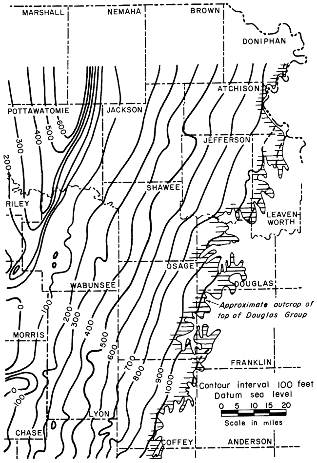
Figure 5 is included in the present report mainly to offer a means of determining approximate depth from ground level to the sandstones of the Douglas and Pedee Groups. The top of the Douglas Group was judged to be the best datum upon which to draw structure contours for this purpose, and its depth below the surface can be determined in any given locality simply by algebraically subtracting the elevation of this datum from ground elevation. Approximate depth of the Douglas Group increases to 1,400 feet in the southwest corner of the area west of the outcrop belt. Within the structural trough east of the Nemaha Anticline the depth to the Douglas Group ranges from an average of rerhaps 1,100 feet in the north to about 1,300 feet in Morris County.
Much has been written about the origin of Pennsylvanian sandstones in Kansas and neighboring states. The basal member of the ideal cyclothem in this region is composed of subaerially deposited sandstone, which lies disconformably upon older strata (Weller, 1930, p. 102; Moore, 1950, p. 6). Evidence presented by the cyclic repetition of lithologic types over wide areas in central United States indicates that the land surface during time of deposition was flat enough that slight relative changes in sea level could cause extremely widespread submergence or emergence (Moore, 1950, p. 16). It was during these periods of emergence that most of the Pennsylvanian sandstones were deposited on eroded, though low-lying, land surfaces. Not all Pennsylvanian sandstones are continental, of course, but marine sandstones are relatively few and probably represent near-shore deposits that "accumulated contemporaneously with aggradation of the alluvial plain" (Weller, 1931, p. 172).
With the possible exception of the local sandy phase of the Vinland Shale, all sandstone in the Douglas and Pedee Groups is almost certainly of continental origin. The plant remains that are found in outcrops suggest this, and shape of the sand bodies in long, branching, and relatively narrow trends as shown on Plates 1 and 2, the crossbedding, and the disconformable relation to older strata seen in surface exposures all indicate deposition by stream channel filling. In most places the massive, crossbedded sandstone occurs in areas where the underlying disconformity cuts most deeply into older rocks, or, in other words, in areas of main channel deposition. The thin-bedded, fine-grained sandstone presumably was deposited along channel margins in calm water. Possibly the cause of deposition was lessening of velocity of the streams near the mouth because of a steadily rising base level during enroachment by Pennsylvanian seas.
Recent work by Winchell (1957) in the subsurface of southern Kansas has disclosed, in the Sedgwick Basin, marine sandstone (Stalnaker) equivalent to the Tonganoxie. Extending southward into this basin from the area included in the present report are several small channels filled with Tonganoxie Sandstone. These channels are interpreted as the southward continuation of the Tonganoxie Valley, and probably represent a distributary system developed by basinward drainage.
Water obtained from sandstones of the Douglas Group is used extensively in northeastern Kansas for both municipal and domestic supplies. In the outcrop area and for a considerable distance down dip (west), the Ireland and Tonganoxie sandstones are important aquifers. Water from both of these sources is generally of good quality near the outcrop, but commonly becomes harder and brackish farther west with increasing depth to a point where it is unsuitable for drinking (H. G. O'Connor, personal communication).
Several small municipalities in Leavenworth, Douglas, Franklin, Osage, and Coffey counties obtain all, or nearly all, of their water supplies from these sandstones. The water systems of Wellsville, Baldwin, and Waverly are supplied entirely from Ireland Sandstone, and Quenemo gets water partly from Ireland Sandstone and partly from Pleistocene gravels. Tonganoxie Sandstone provides water for the towns of Overbrook and Tonganoxie. Pomona, in northwestern Franklin County where Ireland and Tonganoxie sandstones are in contact, may obtain water from both sources.
Sandstones of the Douglas and Pedee Groups occur in definite channel-like trends, which are interpreted as alluvium-filled river valleys. Mapped as two aggregate units according to their stratigraphic position above or below the Haskell Limestone, the distribution of these deposits shows at least two distinct drainage patterns controlled chiefly by the streams that deposited the Ireland and Tonganoxie Sandstones.
Above the Haskell Limestone, where the Ireland member of the Lawrence Shale is the dominant sand body, the sandstones occur in two major trends. The most important of these, an ancient river valley probably more than 100 feet deep, follows an irregular westward course across the central part of the area. Tributary to this is a second channel, in places as much as 90 feet deep, which extends southward from Nemaha and Brown counties to merge with the main channel in Wabaunsee County. Other deposits, locally attaining considerable thickness, are present in the southwestern part of the area.
Two major trends are evident also in the deposition of sandstone below the Haskell Limestone. Here the Tonganoxie Sandstone is dominant, having been deposited in a southwest-trending valley that in places is more than 140 feet deep. This valley is prominent in the eastern part of the area, roughly parallel to the outcrop of Douglas-Pedee strata, and seemingly is continuous with the "Tonganoxie Valley" mapped by Lins (1950). The other major trend of sandstone deposition joins this Tonganoxie Valley in southeastern Lyon County and has been traced southward from Nemaha County.
All sandstones of the Douglas and Pedee Groups have similar physical characteristics, but a few laboratory analyses indicate that there may be some minor differences between the Ireland and Tonganoxie Sandstones. All samples from the Tonganoxie are better sorted than samples from the Ireland, and all are predominantly fine sand. The Ireland samples studied, on the other hand, have diverse predominant size grades ranging from medium sand to coarse silt. Two Ireland sample localities are outside of major channel trends, however, whereas all samples of Tonganoxie Sandstone were collected from main channel deposits.
Composition of all sandstones studied is essentially the same. Subangular to angular quartz grains make up about 90 to 95 percent of the volume of all samples analyzed, the remainder being composed mostly of thin flakes of muscovite, some tourmaline, and rare chlorite grains. Relative quantity of muscovite seems to be greater in silty, thin-bedded sandstone from channel borders than in massive, crossbedded sandstone from main channels.
Although the coefficient of permeability of Douglas-Pedee sandstones is low, main channel deposits averaging between 100 and 200 meinzers, these sandstones are the principal aquifers in parts of northeastern Kansas for both domestic and municipal water supply. Knowledge of where they have considerable thickness in the subsurface should aid in locating additional supplies of ground water and possibly in selecting reservoirs for underground storage of surplus water during periods of ample surface supply.
Bass, N. W. (1934) Origin of Bartlesville shoestring sands, Greenwood and Butler counties, Kansas: Am. Assoc. Petroleum Geologists, Bull., v. 18, p. 1313-1345.
Bass, N. W. (1936) Origin of the shoestring sands of Greenwood and Butler Counties, Kansas: Kansas Geol. Survey, Bull. 23, p. 1-135. [available online]
Bowsher, A. L., and Jewett, J. M. (1943) Coal resources of the Douglas Group in east-central Kansas: Kansas Geol. Survey, Bull. 46, p. 1-94. [available online]
Cadman, W. K. (1927) The Golden Lanes of Greenwood County, Kansas: Am. Assoc. Petroleum Geologists, Bull., v. 11, p. 1151-1172.
Charles H. H. (1927) Oil and gas resources of Kansas, Part VII, Anderson County: Kansas Geol. Survey, Bull. 6, pt. 7, p. 1-95.
Cheney, A. E. (1929) Madison shoestring pool, Greenwood County, Kansas: Structure of typical American oil fields, v. 2, Am. Assoc. Petroleum Geologists, Tulsa, p. 150-159.
Fishel, V. C. (1942) in Wenzel, L. K., Methods for determining permeability of water-bearing materials: U. S. Geol. Survey, Water-Supply Paper 887, p. 56-65. [available online]
Jewett, J. M. (1951) Geologic structures in Kansas: Kansas Geol. Survey, Bull. 90, pt. 6, p. 107-172. [available online]
Krumbein, W. C., and Pettijohn, F. J. (1938) Manual of sedimentary petrography: D. Appleton-Century Co., Inc., New York, p. 1-549.
Krumbein, W. C., and Sloss, L. L. (1951) Stratigraphy and sedimentation: W. H. Freeman and Co., San Francisco, p. 1-497.
Laughlin, D. J. (1957) Geology of northwestern Franklin County, Kansas: Thesis, Kansas Univ., Lawrence, 96 p.
Lins, T. W. (1950) Origin and environment of the Tonganoxie Sandstone in northeastern Kansas: Kansas Geol. Survey, Bull. 86, pt. 5, p. 108-140. [available online]
Low, J. W. (1950) Subsurface maps and illustrations, in Leroy, L. W., Subsuriace geologic methods: Colorado School Mines, Golden, p. 894-968.
Moore, R. C. (1929) Environment of Pennsylvanian life in North America: Am. Assoc. Petroleum Geologists, Bull., v. 13, p. 459-487.
Moore, R. C. (1931) Pennsylvanian cycles in the northern mid-continent region: Illinois Geol. Survey, Bull. 60, p. 247-257.
Moore, R. C. (1932) A reclassification of the Pennsylvanian System in the northern mid-continent region: Kansas Geol. Soc., Guidebook, 6th Ann. Field Conf., p. 79-98.
Moore, R. C. (1949) Divisions of the Pennsylvanian System in Kansas: Kansas Geol. Survey, Bull. 83, p. 1-203. [available online]
Moore, R. C. (1950) Late Paleozoic cyclic sedimentation in central United States: 18th Internat. Geol. Cong., Great Britain, Rept. pt. 4, p. 5-16.
Moore, R. C., Frye, J. C., Jewett, J. M., Lee, Wallace, and O'Connor, H. G. (1951) The Kansas rock column: Kansas Geol. Survey, Bull. 89, p. 1-132. [available online]
Mudge, M. R. (1956) Sandstones and channels in Upper Pennsylvanian and Lower Permian in Kansas: Am. Assoc. Petroleum Geologists, Bull., v. 40, p. 654-678.
Patterson, J. M. (1933) The Douglas Group of the Pennsvlvanian System in Douglas and Leavenworth counties, Kansas: Thesis, Kansas Univ., Lawrence, 35 p.
Pierce, W. G., and Courtier, W. H. (1935) Englevale channel sandstone of Pennsylvanian age, southeastern Kansas: Am. Assoc. Petroleum Geologists, Bull., v. 19, p. 1061-1064.
Reger, D. B. (1931) Pennsylvanian cycles in West Virginia: Illinois Geol. Survey, Bull. 60, p. 217-239.
Rich, J. L. (1923) Shoestring sands of eastern Kansas: Am. Assoc. Petroleum Geologists, Bull., v. 7, p. 103-113.
Rich, J. L. (1926) Further observations on shoestring oil pools of eastern Kansas: Am. Assoc. Petroleum Geologists, Bull., v. 10, 568-580.
Rich, J. L. (1933) Angular coal fragments as evidence of a long time break in Pennsylvanian sedimentation in eastern Kansas: Geol. Soc. America, Bull., v. 44, p. 865-870.
Rubey, W. W., and Bass, N. W. (1925) Geology of Russell County, Kansas: Kansas Geol. Survey, Bull. 10, pt. 1, p. 1-104.
Stout, Wilbur (1931) Pennsylvanian cycles in Ohio: Illinois Geol. Surve, Bull. 60, p. 195-216.
Tarr, R. S. (1934) Origin of Bartlesville shoestring sands, Greenwood and Butler counties. Kansas: Am. Assoc. Petroleum Geologists, Bull., v. 18, p. 1710-1712.
Twenhofel, W. H., and Tyler, S. A. (1941) Methods of study of sediments: McGraw-Hill, New York, 183 p.
Wanless, H. R. (1931) Pennsylvanian cycles in western Illinois: Illinois Geol. Survey, Bull. 60, p. 179-193.
Wanless, H. R., and Shepard, F. P. (1936) Sea level and climatic changes related to late Paleozoic cycles: Geol. Soc. America, Bull., v. 47, p. 1177-1206.
Weller, J. M. (1930) Cyclical sedimentation of the Pennsylvanian Period and its significance: Jour. Geol., v. 38, p. 97-135.
Weller, J. M. (1931) The conception of cyclical sedimentation during the Pennsylvanian Period: Illinois Geol. Survey, Bull. 60, p. 163-177.
Wentworth, C. K. (1922) A scale of grade and class terms for clastic sediments: Jour. Geol., v. 30, p. 377-392.
Winchell, R. L. (1957) Relationship of the Lansing Group and the Tonganoxie ("Stalnaker") Sandstone in south-central Kansas: Kansas Geol. Survey, Bull. 127, pt. 4, p. 123-152. [available online]
Kansas Geological Survey, Sandstones of the Douglas and Pedee Groups in Northeastern Kansas
Placed on web Jan. 17, 2009; originally published in May 1959.
Comments to webadmin@kgs.ku.edu
The URL for this page is http://www.kgs.ku.edu/Publications/Bulletins/134_3/index.html