![]()
Prev Page--Introduction || Next Page--Hydrology
Geology
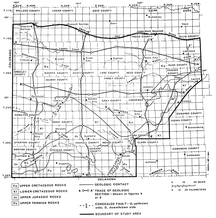
The geologic formations described in this report belong to the Upper Permian Series, the Upper Jurassic Series, and the Lower and Upper Cretaceous Series. Permian formations that are discussed include the Whitehorse and the Big Basin formations. The Jurassic formations are not differentiated. The discussions of Cretaceous formations include the Cheyenne Sandstone, the Kiowa and Dakota formations, and the Codell Sandstone Member of the Carlile Shale. The geology of the pre-Ogallala (Pliocene and Miocene) bedrock surface is shown in fig. 3. This map shows the areal extent of Upper Permian, Upper Jurassic, and Lower and Upper Cretaceous rocks.
Figure 3--Geology of the pre-Ogallala (Pliocene and Miocene) bedrock surface, southwestern Kansas.
Geologic sections
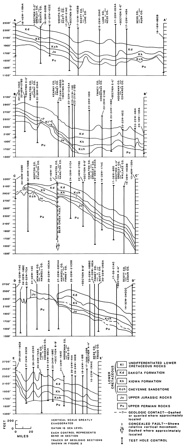
Geologic sections show the correlation, stratigraphic position, and structure of various formations. Gamma-gamma, neutron, and spontaneous-potential logs, obtained from oil- and gas-exploration tests, were used in the construction of geologic sections A-A' to E-E' (fig. 4). Geologic detail between geophysical logs was transferred from structure maps introduced in later sections of this report.
Some notable geologic features are seen on these geologic sections. In some localities, sections display large differences in formation thicknesses within a few miles. In section C-C', the trace of Bear Creek fault and the approximate amount of bed displacement are shown. The upthrown block is on the north side of the fault. Rocks of Late Jurassic age are shown in geologic sections A-A' through D-D' (fig. 4), and their eastern limit is shown in sections A-A', B-B', and D-D'. At the southern ends of sections C-C' and D-D', the limit of Lower Cretaceous rocks is shown. At this location, the formations have a moderate dip toward the north into the Anadarko Basin (Merriam, 1963). At the southern end of section E-E', the formations appear as synclines and anticlines.
Figure 4--Geologic sections constructed from information obtained from oil- and gas-exploration tests.
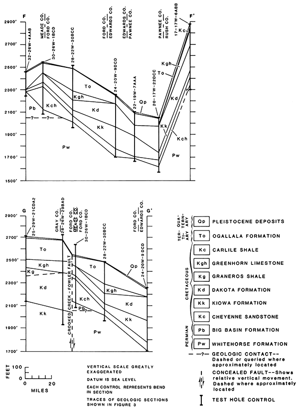
Geologic sections F-F' and G-G' (fig. 5) are based on test drilling conducted in six counties along the eastern border of the study area during this investigation. Formation tops of Permian and Cretaceous rocks and Tertiary and Quaternary deposits were determined from lithologic sample logs (listed in table 7 at the end of this report) and from borehole geophysical logs measuring resistivity, spontaneous potential, and natural gamma-ray response in the test holes.
Sections F-F' and G-G' reflect some of the major structural features that have affected geologic formations from Permian to Tertiary age. The structural depression, as seen on section F-F' in Ford, Edwards, and Pawnee counties, represents part of the Dodge City Basin (also called the Hugoton embayment of the Anadarko Basin; Merriam, 1963). The steep slope of the formations marks the boundary of an adjacent upland in Edwards, Pawnee, and Rush counties that is part of the Central Kansas Uplift (Merriam, 1963). In Rush and Pawnee counties, the Greenhorn Limestone and Carlile Shale have been truncated to the west of the uplift; also, the Ogallala Formation is very thin here. In section G-G', the Crooked Creek-Fowler fault, a normal, tension-type fault, is shown in Ford and Meade counties. Displacement of beds of Permian to Tertiary age is shown. The thickness of the Cretaceous formations on the east side of the fault (upthrown side) is markedly thinner than that on the west side (downthrown side), indicating that the fault was active during the period of Cretaceous deposition. The Big Basin and the Whitehorse formations are shown in geologic sections F-F' and G-G' (fig. 5). The contact between these two formations was determined approximately in the cross section and is shown by dashed lines.
Figure 5--Geologic sections constructed from information obtained from test drilling conducted during this investigation.
Upper Permian Series
Rocks of Permian age crop out in Meade County and occur in the subsurface throughout the study area. They underlie and are in direct contact with rocks of Jurassic and Cretaceous age and deposits of Tertiary and Quaternary age. Permian formations containing sandstones that immediately underlie Jurassic and Cretaceous rocks are the Whitehorse Formation in the northeastern part of the study area and the Big Basin Formation in the southwestern part of the area (Merriam, 1963). In Morton, Stevens, Seward, and Meade counties, the Big Basin Formation immediately underlies rocks of Tertiary age or deposits of Quaternary age in the area where rocks of Jurassic and Cretaceous age are not present.
The lithology of Permian rocks in Kansas consists of red feldspathic clastic sediments (sandstone, siltstone, and shale), evaporite deposits (gypsum, anhydrite, and salt), limestone, and dolomite (Zeller, 1968). In the study area sandstone units consist of alternating lithologies of reddish-brown clay, shale, and siltstone that are thinly interbedded. The sandstones are commonly very fine grained.
The Whitehorse Formation consists of red fine-grained feldspathic sandstone, coarse-grained siltstone, clay, and shale with a minor amount of dolomite. The Big Basin ("Taloga") Formation consists of red silty shale, siltstone, and dolomitic siltstone. Locally, the formation may contain some fine-grained sandstone.
The depth below land surface to the top of the Permian rocks ranges from zero at the outcrop in Meade County and increases northwestwardly to about 2,100 ft in Wallace County (Kume and Spinazola, 1983). The altitude of the top of the Permian surface ranges from just below 1,300 ft in northwestern Rush County to approximately 3,400 ft in Morton County (fig. 6). The surface is quite irregular and dissected, but it dips to the northeast at approximately 19 ft/mi from Morton to Finney counties and approximately 8 ft/mi from Finney to Rush counties. Two prominent faults are shown in fig. 6 (sheet 1). The Bear Creek fault occurs in Hamilton, Kearny, Stanton, and Grant counties, and the Crooked Creek-Fowler fault complex occurs in Meade and Ford counties.
Upper Jurassic Series
Rocks of Late Jurassic age crop out in Morton County and occur in the subsurface in the western half of the study area. The rocks underlie and are in direct contact with rocks of Cretaceous and Tertiary age. Although rocks of Jurassic age are undifferentiated in this report, the Morrison Formation is discernible in the lithologic logs of some wells (Kume and Spinazola, 1982, p. 25-88).
Rocks of Jurassic age in Kansas consist of varicolored shales and red sandstones (Zeller, 1968). Sand, siltstone, and shale were logged in the drill cuttings examined in well 21-35W-09DA, an oil and gas test in Kearny County (Kume and Spinazola, 1982, p. 57). The Morrison Formation in Kansas consists of green sandy shale containing limestone lenses and shales containing chert, anhydrite, and gypsum (Zeller, 1968).
The depth below land surface to the top of the Upper Jurassic rocks ranges from 0 at the outcrop in southwestern Morton County, to approximately 2,000 ft in Wallace County (Kume and Spinazola, 1983). The increase in depth is not uniform. About one-half of the subsurface occurrence of Jurassic rocks in the southwestern part of the study area is less than 600 ft deep.
The top of Upper Jurassic rocks ranges in altitude from just over 1,400 ft in Logan County to approximately 3,500 ft in Morton County (fig. 7, sheet 1). In general, the altitude increases uniformly except near the southwestern' corner of the area and along the Bear Creek fault where considerable bed disruption and displacement have occurred.
The thickness of rocks of Late Jurassic age ranges from 0 ft along the eastern limit to a maximum of approximately 250 ft in northwestern Scott County and averages 103 ft. Thickness changes considerably within short distances, and thicknesses of more than 200 ft occur at several scattered sites in Scott, Greeley, Morton, and Stanton counties (Kume and Spinazola, 1983).
The sandstone beds in rocks of Late Jurassic age range in thickness from 0 ft at several scattered locations and along the eastern limit to approximately 50 ft at several sites in Grant, Hamilton, Kearny, Morton, and Stanton counties (fig. 8, sheet 1). The average thickness of the sandstone beds is 24 ft. Sandstone beds may be continuous locally but, because of their lenticular nature, exhibit little regional continuity or uniform thickness in the study area.
Lower Cretaceous Series
Rocks of Early Cretaceous age crop out in Ford, Hamilton, Hodgeman, Kearny, Pawnee, and Stanton counties. The Lower Cretaceous Series is composed of the Cheyenne Sandstone, the Kiowa Formation, and the Dakota Formation. In Kansas these formations consist of interbedded shales, siltstones, and sandstones. The oldest Cretaceous rocks are of a nonmarine and littoral origin, laid down in advance of an encroaching sea. Next, brackish marine sediments were deposited, followed by marine shales and sandstones. Parts of the Cheyenne Sandstone and Dakota Formation are of nonmarine origin (Zeller, 1968).
Lower Cretaceous formations were not differentiated in five local areas in Finney, Grant, Gray, Haskell, Hodgeman, Kearny, Morton, Scott, Stanton, and Wichita counties. In these areas, the geophysical logs examined show no discernible characteristics to distinguish the individual formations from one another.
Cheyenne Sandstone
The Cheyenne Sandstone in Kansas consists of white, buff, and light-gray fine-grained sandstones and gray sandy shales (Zeller, 1968). Based on lithologic samples from test holes, the Cheyenne Sandstone in the study area consists of shale, siltstone, clay, and sandstone. The sandstone is very fine grained, friable to cemented, white to light-gray, silty, shaly, and thin bedded, with minor amounts of carbonaceous material. In the study area, the Cheyenne Sandstone consists mostly of clay or shale, and sandstone beds tend to be local and discontinuous.
The depth below land surface to the top of the Cheyenne Sandstone ranges from approximately 150 ft in northern Morton County to approximately 1,950 ft in Wallace County. The depth increases toward the northwestern corner of the area in an irregular manner (Kume and Spinazola, 1983).
The altitude of the top of the Cheyenne Sandstone ranges from just over 1,400 ft in Gove County to approximately 3,400 ft in Stanton and Morton counties (fig. 9, sheet 1). The surface has been disrupted by the Bear Creek fault, and a depression occurs in Ford County.
The thickness of the Cheyenne Sandstone ranges from approximately 20 ft in Pawnee County to a maximum of 245 ft in Ford County and averages 91 ft (Kume and Spinazola, 1983). In northwestern Lane County, drill cuttings from test wells show that the Cheyenne is about 230 ft thick. The Cheyenne Sandstone was not differentiated from the Kiowa or Dakota formations in several local areas in Finney, Grant, Gray, Haskell, Hodgeman, Kearny, Morton, Scott, Stanton, and Wichita counties because the logged section was mostly shale. The thickness of the sandstone beds in the Cheyenne ranges from 0 in southeastern Wallace County, northeastern Finney County, and along the limit of the Cheyenne Sandstone to 190 ft in southwestern Hodgeman County and averages 37 ft (fig. 10, sheet 2). In southeastern Rush County drill cuttings from test wells show that the sandstone beds in the Cheyenne are about 165 ft thick.
Kiowa Formation
The Kiowa Formation in Kansas consists of light-gray to black illitic shale. Locally, it contains coquinoidal limestone beds and sandstone lenses. Sandstone lenses are most abundant in central and southwestern Kansas (Zeller, 1968).
The lithology of the Kiowa Formation, based on drill cuttings from nine test-hole sites in the study area, consists of shale, clay, and siltstone, with lesser amounts of limestone and sandstone. The shales arid siltstones generally are dark gray to black but are occasionally varicolored. A 1-ft-thick limestone bed occurs near the base of the Kiowa Formation. The sandstone is very lenticular, thin bedded, and fine grained. No sandstone was logged from the Kiowa Formation at several of the drilling sites. The Kiowa Formation is considered to be a confining bed.
The thickness of the Kiowa Formation ranges from approximately 30 to 190 ft in test holes. Sandstone, where it occurs in the formation, ranges in thickness from 10 to 35 ft, based on geophysical logs. The sandstone is best developed in Gove, Lane, Ness, Rush, and Trego counties (Kume and Spinazola, 1982).
The altitude of the top of the Kiowa Formation ranges from approximately 1,600 ft in the counties along the northern boundary of the study area to approximately 3,500 ft in Morton County (fig. 11, sheet 2). The slope of the surface is fairly regular in the western part of the study area but irregular elsewhere.
Dakota Formation
The Dakota Formation in Kansas is composed of claystone, mudstone, shale, siltstone, and sandstone. The varicolored sediments are white, gray, red, brown, and tan and contain carbonaceous material and lignite (Zeller, 1968). The Dakota Formation crops out in Ford, Hamilton, Hodgeman, Kearny, Pawnee, and Stanton counties.
The Dakota Formation, as indicated by lithologic samples in test holes drilled for this study, consists of interbedded shale, clay, and sandstone, with minor amounts of siltstone and lignite. The sediments vary in color from light to dark gray, red to reddish brown or orange, pink, yellow, buff, tan, and brown. The sandstones are mostly very fine to fine grained but locally are medium to coarse grained. They are friable to cemented, clean to clayey, silty, or shaly. Generally the sandstone beds are lenticular. However, upper and lower sandstone beds in the formation persist throughout most of the area.
The depth to the top of the Dakota Formation and undifferentiated Lower Cretaceous rocks ranges from 0 at the outcrop to approximately 1,650 ft in southwestern Wallace County. Generally, the depth changes markedly over relatively short distances in many areas, except in the northwestern part of the study area (Kume and Spinazola, 1983).
The altitude of the top of the Dakota Formation or the undifferentiated Lower Cretaceous rocks ranges from just less than 1,800 ft in southeastern Trego County to approximately 3,600 ft in southwestern Stanton County (fig. 12, sheet 2). The surface is disrupted by Bear Creek and Crooked Creek-Fowler faults. A noticeable depression of unknown cause also occurs in northern Ford County.
The thickness of the Dakota Formation ranges from approximately 60 ft in northwestern Rush County to about 460 ft in northwestern Ness County and averages 218 ft. Generally, the thickness of the Dakota is not uniform, and locally it may be markedly thicker or thinner than the average thickness (Kume and Spinazola, 1983).
The thickness of the sandstone beds in the Dakota Formation and undifferentiated Lower Cretaceous rocks ranges from 0 in several scattered areas in Finney, Ford, and Kearny counties and along the limit of the Dakota Formation to 150 ft in southwestern Hodgeman County (fig. 13, sheet 2). The sandstone beds average 58 ft in thickness. The thickness is not uniform throughout the study area, and large differences may occur in some areas within a distance of only a few miles. For example, in western Hodgeman County, the thickness varies from 20 to 150 ft in 8 mi.
The presence and thickness of sandstone beds in the Dakota Formation had no relationship to' the total thickness of the Dakota Formation, based on logs from test wells drilled in the study area. At a drilling site in Rush County almost no sandstone was reported. In contrast, at a drilling site in Ford County 168 ft of sandstone occurred in the Dakota Formation, with 121 ft of the sandstone occurring in a continuous sequence of sandstone beds. At another site in Ford County, the sandstone beds ranged from 1 to 4 ft in thickness and were interbedded with shale throughout an interval of 91 ft.
Upper Cretaceous Series
The rocks of the Upper Cretaceous Series in Kansas are composed of marine shales and limestones. The formations in this series include the Graneros Shale, the Greenhorn Limestone, the Carlile Shale, and the Niobrara Chalk. The Codell Sandstone Member of the Carlile Shale is the only sandstone unit in the Upper Cretaceous Series and is generally very thin and discontinuous (Zeller, 1968). The Graneros Shale, Greenhorn Limestone, and Carlile Shale truncate and are not present at several of the test-drilling sites.
Codell Sandstone Member of the Carlile Shale
The Codell Sandstone Member occurs in Ellis, Gove, Ness, Rush, and Trego counties and crops out in northwestern Rush County (McNellis, 1973). In Kansas it is a fine- to very fine grained sandstone that occurs in the upper part of the Carlile Shale. The Codell Sandstone Member has only local significance, with a maximum thickness of approximately 25 ft in northern Ellis County, and thins to 0 in the northeast and south (Zeller, 1968).
Prev Page--Introduction || Next Page--Hydrology
Kansas Geological Survey, Geohydrology
Placed on web June 14, 2013; originally published 1985.
Comments to webadmin@kgs.ku.edu
The URL for this page is http://www.kgs.ku.edu/Publications/Bulletins/IRR8/03_geol.html