![]()
Prev Page--Introduction || Next Page--Unconsolidated Aquifers
Geohydrology
Description of the Rock
sThe oldest rocks underlying Lane and Scott Counties that are a potential source of ground water to wells are the undifferentiated rocks of Late Jurassic age (table 1). The stratigraphic relation of these rocks and the overlying geologic units is shown on figure 2. Upper Jurassic rocks are at depths ranging from 850 to 1,600 feet (259 to 488 m) below land surface, and consist primarily of variegated shale. A fine-grained silty sandstone at the base of the formation may contain a small quantity of ground water, but the unit has not been tested by wells. Rocks underlying the Jurassic unit are of Permian age, and consist primarily of thick shale and some sandstone that contain very highly mineralized water.
Table 1--Generalized section of geologic units.1
| System | Series | Geologic unit | Thickness, in feet2 |
Physical character | Water supply |
|---|---|---|---|---|---|
| Quaternary | Pleistocene | Loess and dune sand |
0-40 | Silt and fine sand, mostly eolian. Mantles most of the upland and masks much of the valley walls. | Most of the deposits are above water table. Where saturated, locally yield 5 to 10 gpm to wells.3 |
| Alluvium | 0-50 | Stream-laid deposits ranging from sand and gravel to silt and clay. Occurs along principal stream valleys. | Generally above the water table. Where saturated, locally yields about 250 gpm to irrigation wells. | ||
| Undifferentiated deposits |
0-200, median 23 |
Medium to very coarse sand and gravel interbedded with clay, silt, fine sand, and caliche. These deposits are in contact with the Upper Cretaceous rocks where the Ogallala Formation is absent. | Principal aquifer in the south-trending bedrock trough in Scott County. Yields to irrigation wells range from 250 to 1,500 gpm. | ||
| Tertiary | Pliocene | Ogallala Formation |
0-215, median 110 |
Sand, gravel, silt, clay, and caliche, commonly unconsolidated. Locally cemented by calcium carbonate (lime) or silica (opal) into mortar beds. Also contains thin freshwater limestone beds. | Principal aquifer in the area. Yields to irrigation wells range from 100 to 1,700 gpm. |
| Cretaceous | Upper Cretaceous |
Niobrara Chalk |
0-410, median 100 |
Upper unit (Smoky Hill Chalk Member) consists of yellow to orange-yellow chalk and light- to dark-gray beds of chalky shale that locally weathers to ochre-yellow. Lower unit (Fort Hays Limestone Member) consists of a white to yellow massive chalky limestone; contains thin beds of dark-gray to brownish-gray chalky shale. | Yields as much as 1,000 gpm to wells in south-eastern Scott County where the rocks have been fractured. |
| Carlile Shale |
200-295. median 245 |
Upper part consists of a dark-gray to blue-black noncalcareous to slightly calcareous shale that locally is interbedded with calcareous silty very fine sandstone. Lower part consists of very calcareous dark-gray shale and thin interbedded limestone. | Sandstone in upper part may yield 5 to 10 gpm to wells. | ||
| Greenhorn Limestone |
70-160, median 105 |
Alternating light- to dark-gray thin-bedded chalky limestone and calcareous shale. Contains thin layers of bentonite. | Not known to yield significant amounts of water to wells. | ||
| Graneros Shale |
25-60, median 40 |
Dark-gray calcareous shale interbedded with black noncalcareous shale. Contains thin beds of bentonite, gray limestone, and fine-grained silty sandstone. | Not known to yield significant amounts of water to wells. | ||
| Lower Cretaceous |
Undifferentiated rocks |
300-680 median 480 |
Upper unit (Dakota Formation)--brown to gray fine- to medium-grained sandstone interbedded with gray sandy shale and varicolored shale. Middle unit (Kiowa Formation)--dark-gray to black shale interbedded with tan and gray sandstone. Lower unit (Cheyenne Sandstone)-gray and brown fine- to medium-grained sandstone interbedded with dark-gray shale. | Yields of 30 to 300 gpm may be available to wells completed in sandstone beds. Yields of more than 1,000 gpm are reported from wells in counties farther south, but no irrigation wells tap these rocks within the report area. Water may be more mineralized in lower unit than in upper. | |
| Jurassic | Upper Jurassic |
Undifferentiated rocks |
0-200, median 70 |
Gray, noncalcareous shale, interbedded with gray-green and blue-green calcareous shale. Contains fine-grained silty sandstone, and thin limestone beds. | The sandstone beds, although untested, may be a potential aquifer. Water may be mineralized. |
| 1. The classification and nomenclature of the rock units used in this report are those of the Kansas Geological Survey and differ somewhat from those of the U.S. Geological Survey. 2. Thickness in feet × .3048 equals thickness in meters. 3. Yield in gpm (gallons per minute) × .06309 equals L/s (liters per second). |
|||||
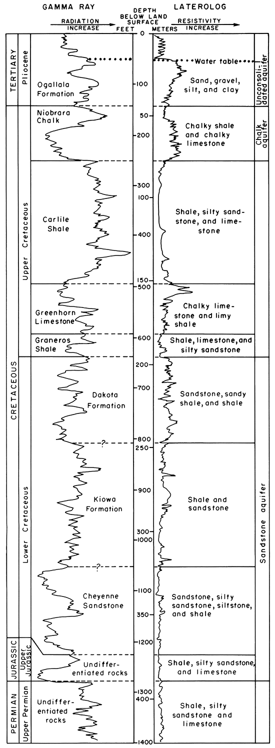
Figure 2--Generalized gamma-ray log and laterolog (focused resistivity) of typical gas and oil test, Lane and Scott Counties.
Undifferentiated rocks of Early Cretaceous age unconformably overlie the Upper Jurassic rocks at depths ranging from 530 to 1,060 feet (162 to 323 m) below land surface. The Lower Cretaceous rocks can be divided into three units in most of Lane and Scott Counties. The lower unit, considered to be the Cheyenne Sandstone, consists mainly of lenticular sandstone interbedded with siltstone and mudstone (shale). Locally, the unit consists of silty sandstone.
The middle unit of the Lower Cretaceous rocks, which generally correlates with the Kiowa Formation, consists of shale interbedded with sandstone. Precise separation of the Kiowa is difficult because similar dark-colored shales also occur in the units above and below.
The upper unit, equivalent in part to the Dakota Formation, consists of sandstone interbedded with shale and sandy shale containing lignite and pyrite. This unit is persistent throughout much of Lane and Scott Counties. Sandstones in the Lower Cretaceous and Upper Jurassic rocks form one of the three aquifers underlying Lane and Scott Counties.
Consolidated rocks of Late Cretaceous age include the Graneros Shale, Greenhorn Limestone, Carlile Shale, and Niobrara Chalk. The aggregate thickness of these rocks is about 500 feet (152 m). The Carlile Shale, exposed locally in the area drained by Hackberry Creek (Prescott, 1951), probably underlies the alluvium of Hackberry Creek. The bedrock surface in the rest of Lane and Scott Counties is on the Niobrara Chalk. The Fort Hays Limestone Member of the Niobrara Chalk, exposed in the Hackberry Creek drainage, probably forms part of the buried bedrock surface in southern Lane County. In Scott County and in northern Lane County, the bedrock surface is formed on the Smoky Hill Chalk Member of the Niobrara Chalk (Waite, 1947; and Prescott, 1951). This member is exposed in numerous drainages throughout the two-county area. Because of fractures and solution openings, the Niobrara Chalk is a significant aquifer in Lane and Scott Counties.
Unconsolidated deposits of sand, gravel, silt, clay, and caliche comprise rocks of Pliocene and Pleistocene age in Lane and Scott Counties. The Ogallala Formation (Pliocene), consisting chiefly of alluvial deposits, is the principal aquifer throughout the two-county area. Alluvial deposits that comprise most of the rocks of Pleistocene age can be distinguished from Pliocene deposits (Gutentag, 1963) by lithologic differences and by their relative stratigraphic positions. These undifferentiated Pleistocene deposits are the principal aquifer in the south-trending bedrock trough south of Scott City (Waite, 1947).
Geologic Structure
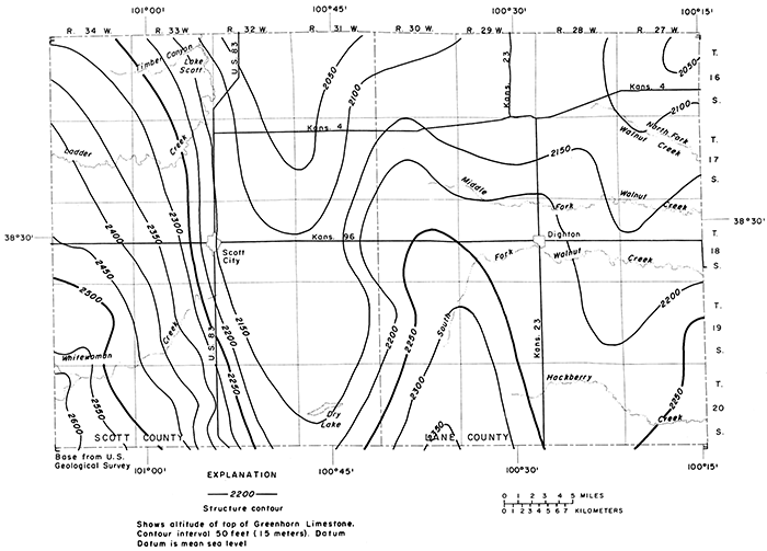
A generalized structure map of the top of the Greenhorn Limestone is shown on figure 3. The top of the Greenhorn Limestone has an average northeasterly dip of 11 feet per mile (2.1 m/km) resulting from uplift of the Las Animas arch (Lee and Merriam, 1954) southwest of the study area. The contours on the structure map show undulations of the Greenhorn Limestone that indicate local folding superimposed on the regional dip. Dominant structural features associated with the folding are a northward-plunging syncline in eastern Scott County, a northward-plunging anticline in western Lane County, and a northward-plunging syncline in eastern Lane County. Deformation of the Greenhorn probably occurred during post-Cretaceous and pre-Pleistocene time (Lee and Merriam, 1954; and Russell, 1929).Figure 3--Configuration of the top of the Greenhorn Limestone.
Configuration of Bedrock Surface
Significant features on a map showing the configuration of the bedrock surface (pl. 1) are (1) a general slope from west to east, (2) a conspicuous south-trending trough in central Scott County, (3) a prominent bedrock high north of Dry Lake, (4) tributary valleys, and (5) badland topography developed on the land surface where the bedrock is exposed.
The bedrock surface depicted on plate 1 slopes easterly across the two-county area at an average rate of 9 feet per mile (1.7 m/km), but with large local departures from average, and some local reversals in direction. The bedrock surface in western Scott County slopes eastward at about 15 feet per mile (2.8 m/km), which is comparable to the slope in adjacent Wichita and Greeley Counties (S. E. Slagle, personal commun., 1974). The bedrock surface slopes at an average rate of 7 feet per mile (1.3 m/km) across eastern Scott County and Lane County. The land surface, however, slopes eastward across the two-county area at an average rate of 11.5 feet per mile (2.2 m/km). The difference in slope of the bedrock and land surfaces generally results in a thickening of the unconsolidated deposits across western Scott County and a thinning from central Scott County to eastern Lane County where the bedrock is exposed.
A conspicuous south-trending trough, about 3 to 6 miles (5 to 10 km) in width, extends from northern Scott County to the Finney County line at right angles to the general direction of slope of the bedrock surface. This trough is the northern continuation of a major bedrock channel in Finney County (Gutentag and others, 1972). A lack of gradient throughout the trough may be the result of minor structural deformation in this area not evident on the map showing the configuration of the top of the underlying Greenhorn Limestone (fig. 3).
A prominent bedrock high north of Dry Lake is on the west edge of a resistant erosional remnant that coincides with a plunging syncline, as shown by the structural map of the Greenhorn Limestone (fig. 3). This remnant is evidently the result of differential erosion of less resistant rocks at the margin of the plunging syncline.
The significance of the tributary valleys is exemplified by the southeastward-trending valleys in T. 19 S., R. 33 W. and T. 20 S., R. 33 W.; which are tributary to the major south-trending trough. These buried tributary valleys are filled with coarse-grained deposits that yield large quantities of water to wells. The water-yielding deposits are almost fully developed with respect to their irrigation potential. The development of irrigation wells near Dighton indicates that a northeastward-trending valley contains similar coarse-grained deposits.
The bedrock formations are exposed in northern and southeastern Lane County allowing visual inspection of the bedrock configuration. The complex contours in this area represent the bedrock surface where it is visible; whereas, the generalized contours represent an interpretation of the bedrock surface based on logs of test holes and wells. A very intricately sculptured bedrock surface would be revealed if the unconsolidated deposits were stripped off.
The configuration of the present land surface in Lane and Scott Counties, in part, reflects features of the bedrock configuration. The elongate north-south surface depression that includes the Whitewoman Basin in south-central Scott County, known locally as the "Scott-Finney depression", overlies the south-trending trough in the bedrock. The bedrock high in southeastern Scott County is reflected by topographic highs at the surface.
Sandstone Aquifer
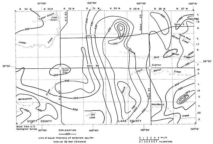
The sandstone aquifer is defined here to include all rocks of Late Jurassic and Early Cretaceous age in Lane and Scott Counties. The depth to the top of the sandstone aquifer (fig. 4) ranges from 530 feet (162 m) in eastern Lane County to 1,060 feet (323 m) in central Scott County. The thickness of the sandstone aquifer (fig. 5) ranges from 430 feet (131 m) in southwestern Scott County to 710 feet (216 m) in southwestern Lane County.
Figure 4--Depth to the top of the sandstone aquifer.
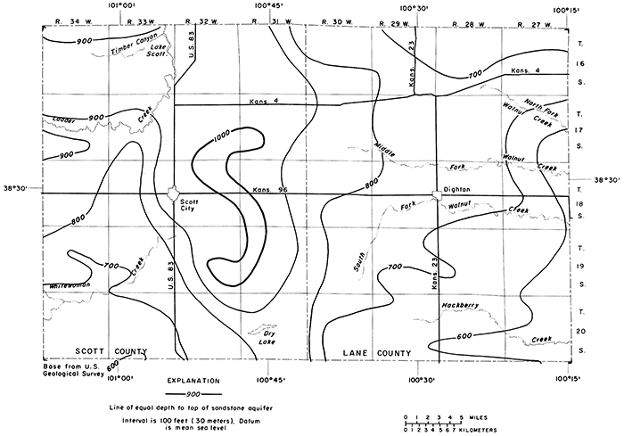
Figure 5--Thickness of the sandstone aquifer.
Only the major sandstone beds in the sandstone aquifer contain significant amounts of recoverable water. As an example, the generalized gamma-ray log and laterolog in figure 2 shows the total thickness of the aquifer to be 635 feet (194 m), but only about 170 feet (52 m) is sandstone. Locally the sandstone beds are silty or tightly cemented, and in such localities wells in the aquifer yield sufficient water only for domestic or stock supplies. In some counties to the south and east, ground water in sufficient quantities for irrigation is obtained from loosely cemented sandstone beds of equivalent age. Yields of as much as 1,000 gpm (63 L/s) have been obtained from the sandstone aquifer by irrigation wells in the panhandle area of Finney County and in Hodgeman County.
Geophysical logs, especially the laterolog resistivity curves, may be used to indicate the relative degree of mineralization of fluids contained in the formations penetrated by the borehole. When resistivities of sandstone beds are similar to those of shale, the formational water generally is relatively highly mineralized. For example, sandstone beds shown in figure 2 indicate more highly mineralized water in all beds below the middle of the Kiowa Formation (decrease in resistivity) than that in the Dakota Formation. Therefore, the ranges of thickness on figure 5 should be used only as a general guide because part or perhaps all the water in the sandstone aquifer may be too highly mineralized for most uses. Test drilling and collection of water samples for chemical analysis are important in determining whether the sandstone aquifer contains water of usable quantity and satisfactory quality at a specific site.
Chalk Aquifer
The chalk aquifer is defined as that part of the Niobrara Chalk that contains saturated fractures and solution openings. The occurrence of fractures and solution openings is very irregular, making it difficult to predict whether water will be found. One well drilled in limestone or chalk may penetrate water-filled fractures or solution openings and have an adequate yield. Another well, drilled only a few feet from the first, may not penetrate any fractures or solution openings and will yield little or no water. In drilling for water in an area underlain by limestone or chalk, it commonly is necessary to drill several test holes to locate a well that will yield enough water for the intended use.
In Scott County, six irrigation wells located on the erosional bedrock high in T. 19 S., R. 31 W. are producing from fractures and solution openings in chalk of the Smoky Hill Chalk Member (upper unit of the Niobrara Chalk). These wells are located near the center of the syncline in Scott County shown on figure 3, but there is no evidence that this particular geologic structure controls the location of fractures and solution openings. It is probable that other wells could be drilled into the same fracture system elsewhere in the county. Because the fractures and some solution cavities are thought to be a result of weathering processes before the rocks were covered by younger unconsolidated deposits, test drilling probably could be limited to the yellow or orange weathered chalk.
In the neighboring part of northwestern Finney County about 40 irrigation wells produce water, at least in part, from fractures and solution openings in chalky limestone of the Fort Hays Limestone Member (lower unit of the Niobrara Chalk). In this area the Fort Hays is the uppermost bedrock formation beneath the unconsolidated deposits. Water-well contractors report two major fracture and solution-opening zones in the Fort Hays Limestone Member. These zones lie approximately at 20 feet (6 m) and 40 feet (12 m) above the contact between the Fort Hays Limestone Member and the Carlile Shale. It is possible that saturated fractures and solution openings such as found in the Fort Hays Limestone Member in Finney County also may be found in southern Lane County.
The water in the chalk aquifer in Scott and Finney Counties is derived from the overlying unconsolidated deposits. In T. 19 S., R. 31 W., Scott County, percolating water is transmitted from the land surface through the unsaturated deposits to the fractures and solution openings in the Smoky Hill Chalk Member. In other areas (i.e., Finney County) the chalk aquifer is in direct hydraulic connection with the saturated unconsolidated deposits.
Wells in the chalk aquifer in Scott County may yield 500 to 1,000 gpm (32 to 63 L/s) and in northwestern Finney County 500 to 2,500 gpm (32 to 106 L/s).
Unconsolidated Aquifer
Unconsolidated deposits of Pliocene and Pleistocene age are the principal source of water supply in the study area and are defined here as the unconsolidated aquifer. In Lane County and in much of Scott County, the Ogallala Formation of Pliocene age comprises the major part of the unconsolidated aquifer (See tables 2 and 3 in Stullken and others, 1974, for records of wells and logs of test holes).
The Ogallala Formation in the subsurface of Lane and Scott Counties consists of a heterogeneous assortment of alluvial sediments. Individual beds of silt, clay, sand, gravel, or caliche within the Ogallala can be correlated with confidence over only short distances. The formation ranges in thickness from a few feet near areas where bedrock crops out to as much as 215 feet (66 m) in central Scott County. Yields to irrigation wells range from 100 to 1,700 gpm (6.3 to 107 L/s).
Alluvial deposits of Pleistocene age overlie the Ogallala Formation in much of Lane and Scott Counties. The undifferentiated Pleistocene deposits are the principal aquifer where they fill the south-trending trough in the bedrock in central Scott County. The deposits, which consist of medium to very coarse sand and gravel interbedded with numerous layers of tan silt and clay, range in thickness from a few feet to as much as 200 feet (61 m) in the southern part of the trough. Yields to irrigation wells range from 250 to 1,500 gpm (16 to 95 L/s).
Prev Page--Introduction || Next Page--Unconsolidated Aquifers
Kansas Geological Survey, Geohydrology
Placed on web June 24, 2013; originally published 1976.
Comments to webadmin@kgs.ku.edu
The URL for this page is http://www.kgs.ku.edu/Publications/Bulletins/IRR1/03_geohy.html