Kansas Geological Survey, Guidebook 4, originally published in 1979
Next Page--Coal, Heavy-oil, Crinoids
Originally published in 1978 as Kansas Geological Survey Guidebook 4.
Created for the Ninth International Congress of Carboniferous Stratigraphy and Geology (IX-ICC), May 27 to May 30, 1979
We are indebted to many persons whose generosity and aid helped make this field trip and guidebook possible. Iowa graduate student Rex Price aided in field and laboratory work and he, Steve Schutter and John Mitchell provided important information from their dissertation projects. Helen Wolfe of the Kansas Geological Survey arranged for field trip meals, lodging and transportation. The following persons allowed access to their (or their company's) property for certain field trip stops: Jim Haddan (Stop 4), Leon Engelmann (Stop 5B), Richard Atkinson, Midwest Minerals Co. (Stop 8), John Mackie, Jr., Clemens Coal Co. (Stops 9, 10), Joe Oliva, City Wide Quarries (Stop 19), Mrs. Orren Derby (Stop 20), G.M. Summy, Ash Grove Cement Co. (Stop 21), Chester Hopper (Stop 22). Renate Hensiek coordinated drafting of most diagrams at the Kansas Geological Survey. Pam Wright typed the guidebook, with some assistance from Lynne Heckel. The American Association of Petroleum Geologists permitted use in this guidebook of published figures from Heckel (1977). Others at the Kansas Geological Survey who assisted in preparation of the guidebook are Patricia Acker and Patricia Renjifo in graphic arts, David Link, photographer, and editors, Gary Waldron and Nancy Parker, and Esther Price in secretarial assistance.
| 1st Day, Sunday, May 27 | ||
|---|---|---|
| Start loading bus at Holiday Inn Towers, Kansas City, Kansas at 7:10 A.M. | # minutes/time | |
| Leave Holiday Inn Towers at 7:30 A.M. | ||
| Drive about 5 miles (W on K-32) | 10/7:40 | |
| Stop 1: K-32 roadcut W of I-635: Iola Ls., typical Kansas cyclothem | 30/8:10 | |
| Drive 55 miles (S on I-635, S on US-69) | 70/9:20 | |
| Stop 2: US-69 roadcut near LaCygne: Swope Ls. distinct regressive facies | 40/10:00 | |
| Drive 51 miles (S on US-69, W on K-52, S on US-59) | 65/11:05 | |
| Stop 3: US-59 roadcut at Katy Lake: Iola Ls. in algal mound facies belt | 25/11:30 | |
| Drive 21 miles (S and W on US-59) | 30/12:00 | |
| Stop 4 (includes Lunch): US-59 at Canville Ck. bridge: Dennis Ls. mound facies; Galesburg Sh. with coals; Swope Ls. oolitic fauna | 60/1:00 | |
| Drive 27 miles (W on US S9, W on K-39) | 35/1:35 | |
| Stop 5: Wilson Co. State Lake: Stanton Ls. in algal mound facies belt | (100/3:15) | |
| 5A: Plunge pool: Basal Stanton distinct transgressive facies | 45/2:20 | |
| Walk 0.5 mile | 15/2:35 | |
| 5B: Quarry: Middle Stanton offshore facies | 40/3:15 | |
| Drive 17 miles (S on US-75, W on K-47 and gravel roads) | 25/3:40 | |
| Stop 6: Altoona roadcuts: Stanton channel facies and Plattsburg Ls | (140/6:00) | |
| 6A: North Altoona roadcut: Stanton channel edge | 20/4:00 | |
| Drive 1 mile (S, then E on K-47) | 10/4:10 | |
| 6B: K-47 Altoona roadcut: Stanton channel axis | 60/5:10 | |
| Walk 0.4 mile | 10/5:20 | |
| 6C: K-47 Altoona lower roadcut: Plattsburg offmound facies | 40/6:00 | |
| Drive 9 miles (E on K-47, S on US-75) | 15/6:15 | |
| Dinner about 7:15 P.M. and overnight at Old Homestead Motel, Neodesha, Ks. | ||
| 2nd Day, Monday, May 28 | ||
| Start loading bus at Old Homestead Motel at 7:10 A.M. | # minutes/time | |
| Leave Old Homestead Motel at 7:30 A.M. | ||
| Drive 18 miles (E on K-37, E on US-160, S on gravel road) | 25/7:55 | |
| Stop 7: Roadcut SW of Dennis: Dennis cyclothem in transition | 35/8:30 | |
| Drive 35 miles (E on US-160 and K-126, N on gravel road) | 45/9:15 | |
| Stop 8: Quarry SW of Girard: Fort Scott chaetetid reefs | 45/10:00 | |
| Drive 19 miles (E on K-126, S on US-69, E on Co. road) | 30/10:30 | |
| Stop 9: Abd. stripmine SE of Pittsburg: Lower Cherokee delta cycles | (105/12:15) | |
| 9A: N-S highwall: "upper Bluejacket" sandstone | 50/11:20 | |
| Drive 0.7 mile | 5/11:25 | |
| 9B: E-W highwall: "lower Bluejacket" sandstone | 50/12:15 | |
| Drive 9 miles (E and N on County road) | 15/12:30 | |
| Lunch at Chicken Mary's, Yale, Kansas | 60/1:30 | |
| Drive 11 miles (N and W on County roads) | 20/1:50 | |
| Stop 10: Clemens Coal Co. Mine #22: Upper Cherokee coals | 75/3:05 | |
| Drive 20 miles (W on Co. road, N on US-69, W on Co. roads) | 30/3:35 | |
| Stop 11: Jubilee Quarry SW of Ft. Scott: Pawnee Ls., a Middle Penn. cyclothem | 50/4:25 | |
| Drive 65 miles (N on US-69, W on K-31, N on K-7) | 85/5:50 | |
| Stop 12: US-169 roadcut E of Osawatomie: Chanute Shale with coal | 20/6:10 | |
| Drive 52 miles (N on US-169 and K-7, W on K-10) | 60/7:10 | |
| Dinner about 7:45 P.M. and overnight in Lawrence, Kansas (more detailed information on route between stops accompanies stop descriptions) |
||
| 3rd Day, Tuesday, May 29 | ||
| Start loading bus at motel in Lawrence at 7:10 A.M. | # minutes/time | |
| Leave motel at 7:30 A.M. | ||
| Drive about 15 miles (E on K-10) | 25/7:55 | |
| Stop 13: K-10 roadcut E of Eudora: Black shale in Stanton cyclothem | 35/8:30 | |
| Drive 21 miles (W on K-10, W on Kansas Turnpike) | 30/9:00 | |
| Stop 14: Kansas Turnpike cut: Oread Ls., classic "megacyclothem | 60/10:00 | |
| Drive 2.6 miles (W on Turnpike) | 10/10:10 | |
| Stop 15: Kansas Turnpike cut: Lecompton Ls., higher "megacyclothem" | 50/11:00 | |
| Drive 2 miles (W on Turnpike) | 10/11:10 | |
| Stop 16: Kansas Turnpike cut: Deer Creek Ls., higher "megacyclothem" | 30/11:40 | |
| Drive about 15 miles (W on Turnpike and I-70) | 20/12:00 | |
| Lunch in Topeka | 55/12:55 | |
| Drive about 10 miles (W on I-70) | 15/1:10 | |
| Stop 17: I-70 cut W of Topeka: Bern Ls. with a Wabaunsee cyclothem | 30/1:40 | |
| Drive 95 miles (E on I-70, N on US-75, W on N-8, N on N-105) | 120/3:40 | |
| Stop 18: N-105 ditch S of Humboldt: Pennsylvanian-Permian boundary | 60/4:40 | |
| Drive 90 miles (N on N-105, W on N-4, N on N-50, E on I-80) | 110/6:30 | |
| Dinner about 7:15 P.M. and overnight at Howard Johnson's off I-80, south of Omaha, Nebraska | ||
| 4th-Day, Wednesday, May 30 | ||
| Start loading bus at Howard Johnson's, Omaha at 7:10 A-M. | # minutes/time | |
| Leave Howard Johnson's at 7:30 A.M. | ||
| Drive 20 miles (W on I-80, S on N-85 4 gravel roads) | 30/8:00 | |
| Stop 19: Richfield PWA Quarries: Hertha, Swope 4 Dennis Ls | (80/9:20) | |
| 19A: East (new) quarry: upper Hertha and lower Swope | 40/8:40 | |
| Walk across road | 10/8:50 | |
| 19B: West (old) quarry: upper Swope and lower Dennis | 30/9:20 | |
| Drive 10 miles (N and W on gravel roads, S on N-50, W on N-31) | 20/9:40 | |
| Stop 20: Derby Stone Products Quarry: Stanton and Plattsburg Ls | 80/11:00 | |
| Drive 2 miles (E on N-31, S on N-50) | 10/11:10 | |
| Stop 21: Ash Grove Cement Co. Louisville E. Qy.: Stanton Ls | (170/2:00) | |
| Brief resume of cement plant workings | 50/12:00 | |
| Lunch and collecting on fossiliferous shale bed | 60/1:00 | |
| South Bend and higher units | 60/2:00 | |
| Drive 12 miles (S on N-50) | 30/2:30 | |
| Stop 22: Hopper Bros. Weeping Water Qy.: Deer Creek Limestone | 60/3:30 | |
| Drive 125 miles (S on N-50, E on N-2, S on I-29) | 140/5:50 | |
| Dinner about 6:30 P.M. in St. Joseph | 100/7:30 | |
| Drive 35 miles (S on I-29) | 45/8:15 | |
| Overnight at Holiday Inn, Kansas City International Airport | ||
| End of Trip | ||
This field trip will visit a number of exposures of Pennsylvanian rocks in eastern Kansas and southeastern Nebraska (fig. 1) in order to examine the variation in cyclothems observed both laterally along 400 km of outcrop and vertically from Middle Pennsylvanian (lower Desmoinesian Cherokee Group = middle Westphalian) to the upper boundary with the lowermost Permian (Fig. 2). Although the entire stratigraphic range will be visited in the 22 field trip stops, early Upper Pennsylvanian (Missourian ≈ lower Stephanian) rocks are emphasized (12 stops) because of greater familiarity with their stratigraphy and probable environmental interpretation. All stops emphasize interpretive stratigraphy; several stops emphasize fossil collecting, both for open marine abundance and diversity (Stops 6C, 15, 21, 22) and for special environments (oolite shoal, Stop 4; chaetetid reef, Stop 8; inundated coal swamp, Stop 12); and several stops consider economic utilization (oil-bearing sandstone, Stop 9; working strip mine, Stop 10; cement plant, Stop 21; and both working and abandoned limestone quarries, Stops 5, 8, 11, 19-22).
Figure 1--Pennsylvanian outcrop in eastern Kansas and adjacent region, showing stage boundaries by solid lines, and Missourian facies belts separated by x symbols. Circled numbers on field trip route show locations of stops.

Previous field trips to eastern Kansas (e.g., Moore and Merriam, 1959, 1965) and to southeastern Nebraska (e.g., Burchett and Reed, 1967) emphasized regional stratigraphy, identification of cyclothems in the vertical sequence, and correlation of stratigraphic units with other parts of the Midcontinent. Previous trips led by Harbaugh (1962; with others, 1965) focused on local stratigraphy, petrography and recognition of algae in carbonate buildups in southeastern Kansas. Previous trips led by Heckel (1975, 1978) emphasized vertical and lateral facies changes related to depositional phase and original topography in one formation (Stanton) and certain aspects of carbonate petrology of several Missourian limestones in eastern Kansas. Part of the guidebook from the earlier of these trips served as a framework for a paper (Heckel, 1977) presenting a depositional model that explains the vertical cyclic sequence of much of the Midcontinent Pennsylvanian in terms of realistic processes of deposition. In addition to revisiting a few localities from earlier field trips, the present trip encompasses a greater geographic area and stratigraphic interval in order to illustrate application of the depositional model to many formations over a large area.
Bedrock geology of eastern Kansas and western Missouri is characterized by an alternation of laterally persistent Middle and Upper Pennsylvanian sandy shales, from 3 to 30 m thick and containing local sandstones, with laterally persistent limestones from 3 to 15 m thick and containing thin shale beds. These rocks strike generally north-northeast to south-southwest and dip gently westward about 5.5 m/km (30 feet per mile). Northward in Iowa, the outcrop trace swings westward to the eastern limit of Cretaceous cover in Nebraska (Fig. 1). South of the limit of glacial cover, which extends through Kansas City, the more resistant thicker limestone and sandstone units are cut by rivers and streams to form low, irregular, eastward-facing escarpments, prongs, and flat-topped hills that break the otherwise nearly flat plain and allow lateral tracing of major units with ease. North of Kansas City, correlation of most units is much less certain because only scattered exposures are available through a variable cover of glacial deposits.
The Pennsylvanian System in eastern Kansas comprises 49 formations that are subdivided into 129 formally named members and aggregated into 8 groups and 3 stages of the Middle and Upper Pennsylvanian Series (Fig. 2); most of these units are recognized in the states to the north. Although this number of formations and members might seem excessive in only about 700 to 800 m of section., most were established or redefined by R.C. Moore and his co-workers while mapping Kansas and surrounding states in the 1930s and 1940s because of the remarkable lateral persistence of many distinctive thin rock units, some less than 1 m in thickness. Much of the fine subdivision of the stratigraphic hierarchy was fashioned by Moore (1936, 1949) to accommodate the equally remarkable vertical repetition of certain distinctive limestone and shale units throughout most of the sequence.
Figure 2--Columnar section of exposed Pennsylvanian and lowermost Permian rocks in eastern Kansas and southeastern Nebraska, with formations to be visited indicated by Stop numbers. Member names are omitted, but nature of members is shown by discrete lithic symbols within formations. Vertical scale is approximate, with limestones, black shales and coals expanded at expense of gray shales and sandstones. (Adapted from Zeller, 1968, Plate 1)
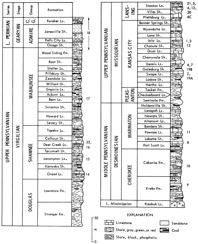
The coarser subdivisions of the Midcontinent Pennsylvanian reflect dominance of certain rock types within the repetitive sequence. At the base of the sequence, the Middle Pennsylvanian (Desmoinesian) Cherokee Group consists mainly of shale, with coal seams, local sandstone bodies, and thin limestone beds. Above the Cherokee, the Marmaton Group forms the top of the Middle Pennsylvanian and is the lowest part of the sequence that consists of an alternation of sandy shale and limestone formations. Above the Marmaton, the lower part of the Upper Pennsylvanian Series constitutes the Missourian Stage in its type area. At its base, the Pleasanton Group consists largely of shale, with a basal sandstone. Most of the Missourian comprises the Kansas City and Lansing Groups, which consist of a thick sequence of alternating sandy shale and limestone formations. The upper part of the Upper Pennsylvanian constitutes the Virgilian Stage in its type area. At its base, the Douglas Group consists largely of shale with thick local sandstones and thin limestones. In the middle, the Shawnee Group is an alternation of sandy shales and thick prominent limestones containing several thin shale members. At the top, the Wabaunsee Group is an alternation of thicker more prominent sandy shales, often containing coal seams, and thinner less prominent limestones. The Virgilian is overlain by Lower Permian rocks that continue the basic alternation of shale and limestone formations.
Cyclothems have long been identified in the repetitive Middle-Upper Pennsylvanian sequence of eastern Kansas and states to the north and east (e.g., Moore, 1936, 1949, 1950; Weller, 19S8; Reed and Burchett, 1966). Moore recognized the basically transgressive-regressive nature of sedimentation responsible for simple cyclothems in the Cherokee and Wabaunsee Groups (Fig. 3A,B), in which largely nonmarine sandy shales with coals alternate with marine shales and limestones. This allowed relatively straightforward depositional interpretation, and the fusulinid-bearing limestone was regarded as the farthest offshore deposit, based upon the paleoecological work of Elias, which was published in 1937.
Figure 3--Types of cyclothems recognized by Moore (1936, 1949, 1950) in Kansas Pennsylvanian. A, Cherokee cyclothem, with marine deposits interpreted from marine fossils, which are mostly pelagic in black shale. B, Wabaunsee cyclothem, with members numbered by Moore (1936, p. 25); black shale is absent, and marine portion shows symmetrical trend of interpreted nearshore-offshore-nearshore fossil assemblages (Moore, 1950). C, Shawnee megacyclothem, in which each shale-limestone member couplet was considered a modified simple cyclothem (A-E), implying that "black shale" member is genetically similar to other shales (sea-level curve 1); similar megacyclothems recognized in Marmaton and Missourian sequence lack "lower", "fifth", and most "super" limestone members; later workers recognized black shale member as genetically distinct from other shale members (sea-level curve 2); (modified from Heckel and Baesemann, 1975, Fig. 1).
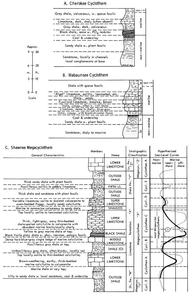
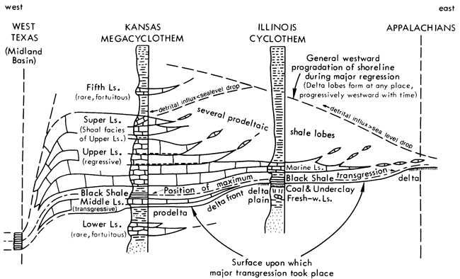
In order to explain the more complex repetitive sequences involving several fusulinid-bearing limestone members in the Shawnee Group, Moore (1936) developed the concept of "megacyclothems" (Fig. 3C). These involve a hierarchical classification of modified simple Wabaunsee cyclothems (A through E), which appear here essentially as shale-limestone couplets, grouped to form a cycle of cyclothems. Megacyclothems thus are complex successions of different shale-limestone couplets, which are repeated in the same order several times upward in the sequence. Moore (1936, 1950) applied the Shawnee megacyclothem classification to the cycles developed in the Marmaton, Kansas City and Lansing Groups below, but recognized that the lowest and highest cyclothems (A, E--corresponding to the "lower" and "fifth" limestone members) are only doubtfully distinguished or definitely lacking. Megacyclothems in all these groups are nucleated around the limestone formations containing the thin shale members, and their boundaries lie within the intervening sandy shale formations (Fig. 3C).
Regarding each shale-limestone couplet in a megacyclothem as an individual simple cyclothem, no matter how modified, had the unfortunate effect of implying that the thin shale carrying the black phosphatic shale facies ("black shale member") is genetically similar to the other shales in the megacyclothem. The resulting interpretation (Fig. 3C, sea-level curve 1) involved rapid nearshore (shale)-offshore (limestone) sea-level oscillations through each megacyclothem, which did not explain why the black shale is so different from the other shales or why several of the limestones are so different from one another. Although Moore (1950, p. 15) interpreted the black shale as deposited in a kind of marine swamp in which thick growth of seaweed prevented bottom disturbance, he nevertheless (ibid.) regarded it as the least well understood member of the megacyclothem, partly because of its greater lateral persistence than almost any of the limestones, which were considered the most offshore deposits. It is ironic that he remarked also (ibid., p. 13) that as megacyclothems are traced southward along outcrop, all limestone members become more separated as the shale members thicken toward the Oklahoma detrital source, except for the two limestones separated by the black shale. This was an important clue that the black shale is genetically unlike the other shales, and, in fact, resulted not from increased detrital influx but rather from more offshore sediment-starved conditions (Fig. 3C, sea-level curve 2) established in deeper water at times when detrital influx was trapped near shorelines far from eastern Kansas (Schenk, 1967; Heckel, 1972; Heckel and Baesemann, 1975; Heckel, 1977).
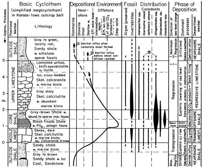
It turns out that only the middle portion of the megacyclothem, specifically the "middle" and "upper" limestone members and intervening thin shale member that typically contains the phosphatic black facies, occurs commonly enough throughout the Marmaton through Shawnee Groups to have basic depositional significance. Each depositional cycle presently recognized by Heckel (1977) in these groups records a single transgressive-regressive marine sequence (Fig. 4), and consists in ascending order, of 1) thick, nearshore sandy ("outside") shale (top of underlying shale formation), 2) thin, transgressive ("middle") limestone, 3) thin, offshore ("core") shale (often with phosphatic black facies), 4) thick, regressive ("upper") limestone, and 5) thick, nearshore sandy shale again (base of overlying shale formation). This explains the difference between the black (=core) shale member and the other shales, and between at least two of the limestone members. A higher limestone member, the "super," which is present in several cycles, is either a shoal-water facies (oolite, etc.) of the upper limestone separated by a fortuitous shale bed, or part of a younger cycle separated by an abnormally thin nearshore shale. A lower limestone member, the "lower," which is present in a few cycles, may be either a minor transgressive-regressive sequence, or a shoal-water facies of the middle limestone separated by a fortuitous shale bed, or the result of temporary cessation of detrital influx during deposition of the nearshore shale.
Each of the major transgressive-regressive depositional units with an offshore shale between two limestones is termed a "Kansas cyclothem." The older usage of "cyclothem" in the Marmaton through Shawnee Groups for essentially a shale-limestone-member couplet within the megacyclothem is abandoned, and the term megacyclothem is applied only to the concept of more complex sequences.
Figure 4--Basic vertical sequence of individual "Kansas cyclothem," the transgressive-regressive depositional unit characterizing., with only minor modification, most of the Marmaton, Kansas City, Lansing and Shawnee Groups of the Midcontinent Pennsylvanian. Positional terms derive from Moore (1936) for limestones and Heckel and Baesemann (1975) for shales. Conodont faunas conspicuously differentiate the two shale members. (From Heckel, 1977, Fig. 2).
Facies and depositional environments are considered for the Marmaton through Shawnee Groups within the framework of the basic Kansas cyclothem (Heckel, 1977), with comments on major facies changes (Fig. 5) observed along the Midcontinent outcrop belt extending southward into Oklahoma and northward into Missouri and Iowa.
Figure 5--Basic pattern of facies change within Kansas cyclothem across facies belts along Midcontinent Pennsylvanian outcrop (Fig. 1). Datum is interpreted sea level when increased detrital influx ended deposition of regressive limestone. (From Heckel, 1977, Fig. 4).
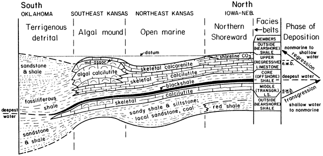
Nearshore shales--Nearshore shales comprise the shale formations that alternate with limestone formations in the cyclic sequence, but include some shale members (marked O on Fig. 3C) within those limestone formations that contain more than one shale member. The dominance of shale formations that lie "outside" the "bundle" of limestones and thin shales that constitutes the limestone formations, led these shale portions (or "members") of the cyclothem to be termed "outside shales" in a positional sense before their depositional significance was thoroughly established.
Nearshore shales are typically sandy; though variable in thickness, they are generally thick, often attaining 15 m and locally 40 m in thickness. Commonly they contain thin layers of siltstone and sandstone carrying macerated plant fragments and only a sparse marine fauna of low diversity. They locally contain deposits that are demonstrably nonmarine, such as coals with underclays, shales with well preserved land plant fossils, and channel sandstones, all lacking marine fossils. They are the units within which Wanless and his co-workers (e.g., 1970) have mapped many deltaic sequences.
A deltaic depositional model of abundant detritus prograding into the shallow sea readily accounts for the characteristics of these shales. Each delta lobe eventually became abandoned as new distributaries formed a shorter route to the sea and started prograding younger lobes in different places (e.g., Ferm, 1970). Variability in thickness of the nearshore shales reflects the local nature of each delta lobe. The nonmarine deposits record the subaerial deltaic plain. The rocks with sparse marine fossils of low diversity record prodelta to delta-front environments where rapid deposition, increased turbidity, and fluctuating salinity reduced both abundance and diversity of marine organisms.
Southward, nearshore shales tend to thin over thickened portions of underlying limestones; then most thicken substantially in the Kansas-Oklahoma border region where they constitute proportionally greater amounts of the sequence (Fig. 5) as they approach a major deltaic detrital source in Oklahoma.
Most nearshore shales tend to thin northward into Iowa and Nebraska away from the major directions of detrital influx. Parts of some become more abundantly and diversely fossiliferous, reflecting less detrital influx with its attendant unstable conditions. Parts of some become red in color, which indicates enough subaerial exposure for complete oxidation and dehydration of iron minerals (Stops 20, 21).
Transgressive limestones--Transgressive limestones are the thin (0.3 to 1.5 m), dense, dark skeletal calcilutites denoted as the "middle" limestone of Moore's megacyclothem. They carry a diverse and a relatively abundant marine biota comprising all the major phyla, including algae, although fossils do not seem abundant on outcrop because of the denseness of the rock. Fine grain size and diverse biota indicate deposition in the open marine environment far enough offshore to be below effective wave base, but above effective base of the photic zone. If shoal-water facies such as oolite, stromatolite and sandstone are present with the skeletal calcilutite, they are only at the base, as seen in the Stanton Formation at Stop 5A on this field trip.
Aside from a few that thicken with increase in phylloid algae content in southeastern Kansas (e.g., Dennis, Stop 4; Stanton, Stop 5), transgressive limestones undergo little lateral facies change either northward or southward, yet several extend laterally for hundreds of miles along outcrop. Thus transgressive limestones generally record widespread marine inundation of the Midcontinent, with carbonate sediment production mainly at depths below effective wave base where minor variations in topography on the underlying delta lobes had little influence over facies.
Offshore shales--Offshore shales are the thin (0.3 to 2.0 m), laterally persistent, nearly nonsandy, gray marine shales that lie between the "middle" and "upper" limestone members within limestone formations and were termed "core shales" by Heckel and Baesemann (1975) because of their central position within the megacyclothem. They typically contain a black fissile facies rich in organic matter,, which generally carries nodules and laminae of nonskeletal phosphorite (e.g., Iola, Stop 1; Pawnee, Stop 11; Eudora, Stop 13) and relatively high concentrations of certain heavy metals. The black facies lacks definitely benthic fossils, carrying mainly conodonts in great abundance, fish remains, orbiculoid brachiopods and a few other fossils reasonably inferred to have been pelagic or epipelagic. The gray facies typically carries only a sparse macrofauna of several benthic invertebrate groups, including echinoderms and articulate brachiopods, often in addition to those fossils found in the black facies. Only away from the black facies do offshore shales carry abundant and diverse macrofossils (Plattsburg, Stop 6C; Stanton, Stops 20, 21). Like transgressive limestones, offshore shales also change laterally very little along the entire length of the outcrop. Those that lose the black facies laterally, in general retain phosphate nodules and abundant conodonts in the otherwise sparsely .fossiliferous gray facies (Iola, Stop 3; Stanton, Stop SB).
Thinness in conjunction with great lateral persistence, fineness of detrital grain size, presence of marine fauna, great abundance of conodonts and conspicuous nonskeletal phosphorite all point to very slow sedimentation away from detrital influx, far offshore in deeper water. Presence of abundant organic matter along with lack of benthic fossils indicates anoxic bottom conditions for the black facies. Lack of bottom oxygen in conjunction with very high concentrations of phosphate and heavy metals is explained as the result of a two-layered quasiestuarine circulation cell in the Midcontinent sea (Fig. 6), established when water became deep enough to form a thermocline above the bottom and prevent replenishment of bottom oxygen by vertical circulation. Surface water blown out of the sea by prevailing Pennsylvanian trade winds (Fig. 7) was replaced by upwelling of deeper phosphate-rich water of the oxygen-minimum zone, drawn in below the thermocline from intermediate depths of the open ocean. Nutrients brought into the photic zone by this upwelling promoted immense blooms of plankton, which settled back into the incoming lower water layer. There its decay depleted the bottom water of already low oxygen, continually enriched it in phosphate (as well as heavy metals that organisms concentrate), and ultimately caused deposition of unoxidized organic matter and conspicous phosphorite on the sea bottom, along with little other sediment, to produce the phosphatic black facies.
Figure 6--Expected patterns of vertical circulation in west-facing tropical epicontinental sea: A, Low sea-level stand when vertical circulation and algal photosynthesis maintain bottom oxygen; B, High sea-level stand when thermocline allows prevailing trade winds to establish large quasi-estuarine circulation cell, which results in depletion of bottom oxygen and concentration of phosphate. (From Heckel, 1977, Fig. 5).
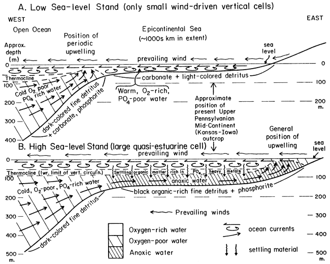
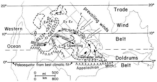
Figure 7--Pennsylvanian paleogeography of North America based on distribution of major coals (c) in ancient doldrums belt, evaporites (Ev) and dune sands (d) in ancient trade-wind belt, and paleomagnetic data. Dashed lines mark maximum transgression when quasi-estuarine cell was operating. (From Heckel, 1977, Fig. 6).
Similar circulation that enriched phosphate but did not deplete all bottom oxygen accounts for the sparsely fossiliferous gray facies with phosphorite nodules. Merely far offshore deposition, probably below the effective limit of algal production of carbonate mud, but without persistent establishment of the oxygen-depleting quasi-estuarine circulation cell, accounts for the more abundantly and diversely fossiliferous gray facies of the offshore shale.
Regressive limestones--Regressive limestones comprise the "upper," sometimes with the "super," limestone members of Moore's megacyclothem. They are generally thicker (up to 9 m) than transgressive limestones and contain a greater variety of facies.
The lower parts of regressive limestones consist largely of wavy-bedded, shale-parted skeletal calcilutite with an abundant and diverse marine biota consisting of all major phyla (all cyclothems at most stops). Lateral persistence of this facies along outcrop in conjunction with fine-grained lithology and diverse biota indicates that this part of regressive limestones, like most of the transgressive limestones, was deposited offshore below effective wave base but above the lower limit of algal carbonate production.
In places a peculiar type of skeletal calcarenite is present at the base of the regressive limestone (Iola, Stop 1; Stanton, Stop SB). These calcarenites consist entirely of invertebrate grains that display no evidence of grain abrasion, cross bedding or definite algal structures, and thus formed in quiet water below effective wave base, and probably below the limit of much algal activity as well.
The upper parts of regressive limestone members display the most conspicuous lateral segregation of facies along the Midcontinent outcrop belt (Fig. 5), as would be expected in shallow water where minor differences in bottom topography produce conspicuous lateral changes in facies.
In northeastern Kansas most regressive limestones grade upward to skeletal calcarenite that contains various proportions of abraded algal as well as invertebrate grains, osagia-coated grains, and grains with "micrite envelopes" resulting from algal boring; cross bedding is apparent in places. Although this vertical succession records increasing water agitation and light penetration with time as water shallowed above effective wave base, this facies still records a relatively open marine environment, which defines this portion of the outcrop belt as the "open marine facies belt" (Fig. 1,5), where such conditions persisted longest during deposition of the regressive limestone. In some places, some regressive limestones show no conspicuous evidence of shallowing upward in this region (Iola, Stop 1). In other places, some regressive limestones display even more conspicuously shoal-water facies at the top such as oolite (Swope, Stops 2, 4) and caliche soil formation (Swope, Stop 2).
Northward, nearly all regressive limestones grade upward into unfossiliferous, laminated, dolomitic calcilutite locally with mudcracks and birdseye; this records a tidal-flat environment and defines the "northern shoreward facies belt," which is best developed in Iowa and Nebraska (especially Stanton, Stops 20-21).
In southeastern Kansas, most regressive limestones thicken as they grade upward into phylloid algal mound facies (Heckel and Cocke, 1969), which defines the facies belt of that name. Mounds consist primarily of algae-dominated skeletal calcilutite, in which large blades of phylloid red and green algae characteristically shelter spar-filled voids (e.g., Dennis, Stop 4). In several mounds, local development of "algal sparite" facies (Iola, Stop 3) records as yet incompletely understood diagenetic alteration of early cements. Mound-associated facies, particularly cross-bedded, abraded-grain skeletal calcarenite and oolite, overlie and flank some of the mound facies (Stanton, Stop 6). These reflect shoaling water over and around the buildups during later stages of regression.
Southward in southernmost Kansas and Oklahoma, most regressive limestones grade into shales and sandstones, which define the "terrigenous detrital facies belt" and represent a wide range of offshore to deltaic environments dominated by terrigenous clastics from the Oklahoma detrital source.
Typical Kansas cyclothems began while rapid detrital influx from nearby deltaic shorelines formed the nearshore shale during a relatively low stand in sea level. This low sea-level stand could have resulted from either a eustatic fall in sea level, or from basin-filling by both the terrigenous detrital influx of the nearshore shale and carbonate accumulation of the underlying thick regressive limestone.
Then transgression, resulting from either a eustatic sea level rise or an increase in bottom subsidence, stranded detrital influx farther away from the Kansas outcrop. This allowed a thin layer of relatively pure carbonate to accumulate relatively uniformly over most parts of the inundated delta lobes, generally in deeper water below effective wave base, to form the calcilutitic transgressive limestone.
When water became deep enough to inhibit much benthic algal activity and to establish a thermocline (perhaps as little as 100 m near the mouth of the sea; see Heckel, 1977, p. 1057), a quasi-estuarine circulation cell was set up. This drew in phosphate-rich, oxygen-poor water from the open ocean, and, through up-welling and the concomitant nutrient-concentrating organic-decay trap, depleted bottom oxygen to various degrees to form both the gray and black phosphatic facies of the offshore shale.
Then relative lowering of sea level destroyed the thermocline and broke up the quasi-estuarine cell. This allowed significant reoxygenation of the bottom and eventually reestablishment of benthic algal carbonate production to initiate formation of the regressive limestone. Eustatic fall of sea level seems much more reasonable to account for this shallowing because too little sediment for significant basin filling is evident in the offshore shale, and tectonic reversal of bottom subsidence, particularly in a cyclic fashion, seems unreasonable. Continued relative lowering of sea level through the photic zone to above effective wave base allowed development of the regressive limestone into shoal water, lagoons, and tidal flats. Greater amounts of fine terrigenous material from distal ends of progressively encroaching deltas account for the greater abundance of shaly partings in most regressive limestones. Although a sufficient thickness of sediment is apparent in the regressive limestone to account for relative lowering of sea level from below to above effective wave base by carbonate basin filling, it seems insufficient to account alone for the small vertical distance between the phosphatic black shale facies and supratidal facies at the top of the regressive limestone, which is as little as 6 m (or 12 m, allowing for 50% compaction), in light of our present understanding of this type of phosphorite deposition.
Deposition of the regressive limestone then ceased when overwhelmed, in various stages of facies development (depending on topographic position, which is related generally to facies belt), by terrigenous detrital influx of prograding delta lobes that initiated development of the succeeding nearshore shale. The cycle then repeated with another relative sea level rise.
Although eustatic rise and fall of sea level from some external control seems to be the simplest explanation for most aspects (and the best explanation for some aspects) of the overall sequence of Kansas cyclothems, this by no means negates the probability that other cyclic mechanisms played a role. In fact, the model of delta progradation, abandonment and subsequent progradation elsewhere, shown to be applicable to other cyclic sequences by several authors (e.g., Ferm, 1970, for the Appalachian Pennsylvanian), not only explains the complex thickness changes and facies development in nearshore shales, 'but also probably accounts for many of the less commonly developed "lower" and "fifth" limestone members in Moore's megacyclothem, as resulting from conspicuous carbonate production during a relatively long-term shift of active delta-building away from the Kansas outcrop during the general phase of greatest regression.
Cherokee cyclothems--The interplay of both depositional models needs only slight modification to account for the simpler cyclothems that Moore (1949, 1950) detected in the Cherokee Group. In the ascending sequence of sandstone-sandy shale-underclay-coal-black shale-gray shale-limestone-calcareous shale, the sandstone through coal portion is nonmarine, whereas the black shale through calcareous shale portion is marine (Fig. 3A). Those sequences in which phosphatic black shales are lacking may reflect no more than local delta abandonment during a time of general regression. These cyclothems, seen at Stop 9, do not require eustatic change in sea level,and they seem to dominate the Cherokee section.
Sequences that contain phosphatic black shales, however, are merely more nearshore detrital-dominated examples of the Kansas cyclothem that characterizes the Marmaton-Missourian-Shawnee section. Nonmarine delta-plain deposits nearly totally dominate the initial "nearshore shale" portion. Transgressive limestones are rarely present above the coal because little or no algae and few calcareous invertebrates could colonize the inimical low-oxygen environment of the deepening sea bottom over partially decayed vegetation of the coal swamp. The little detrital sediment that was carried from the increasingly distant shoreline to Kansas during transgression was incorporated with the shells of the few more tolerant organisms to form the base of the black shale overlying the coal. The remainder of the black shale was deposited during maximum transgression, in depths great enough for establishment of the quasi-estuarine circulation cell that led to formation of the phosphate nodules and totally anoxic bottom conditions.
Lowering of sea level then brought about deposition first of the gray shale as the bottom became reoxygenated, and eventually of the limestone (equivalent to the regressive limestone) as algae and more invertebrates became established. The final unit of calcareous shale is the base of the succeeding nearshore shale and represents nearby prodeltaic detritus encroaching in water too deep for development of shoal-water facies in the regressive limestone. These Cherokee cyclothems are similar to classic Illinois cyclothems, which have been interpreted in a similar fashion by Heckel (1977; see Fig. 8). Cyclothems with phosphatic black shales and regressive limestones but without well developed transgressive limestones (which can be considered Illinois-type cyclothems) occur also above the Cherokee Group (Dennis, Stop 7; Pawnee, Stop 11); lateral appearance of lenses of transgressive calcilutite in the Dennis at Stop 7 attest to the genetic similarity of Kansas and Illinois cyclothems.
Figure 8--Inferred facies change of Kansas cyclothem approaching eastern detrital source and grading to Illinois cyclothem, which is essentially same as Cherokee cyclothem (Fig. 3A). (From Heckel, 1977, Fig. 7).
Wabaunsee cyclothems--The cyclothems described by Moore (1936, 1949, 1950) in the Wabaunsee Group are basically alternations of nearshore sandy shale containing nonmarine sandstones and coals, with marine limestones containing thin marine shale beds (Fig. 3B). The lowest limestone formation (Howard, see Fig. 2) contains a black shale (with gray shale) between a thin dense limestone below and a thicker limestone above, which is similar to the typical Kansas cyclothems in the older groups (Moore, 1936, p. 206).
Unlike the relation between cyclothems and lithic subdivisions in groups below, Wabaunsee nearshore shales above the Howard include both the shale formations and the formally named shale members now included within more recently named limestone formations, whereas the limestone portion of the cyclothem is composed of a single limestone member whether or not it is grouped with another limestone member in a limestone formation (cf. Moore, 1949, p. 180-181, with Zeller, 1968, Plate 1). Although black phosphatic shales have not been reported from any higher Wabaunsee unit, presence of a nonblack offshore shale has been established in the Wakarusa Limestone Member of the Bern Limestone (Stop 17) during layout of this field trip. This bore out the suspicion (Heckel, 1978, p. 19) that laterally persistent limestones with a persistent medial shale bed (the .4 shale of Moore, 1936, p. 25) (see Fig. 3B) probably represent major transgressive-regressive sequences in which water depth did not become quite great enough to establish a quasi-estuarine circulation cell. It is not yet known which of the other Wabaunsee limestones also represent major eustatic inundations and which represent only local delta abandonment during general regression, although the latter are probably of more limited lateral extent.
Drive about 5 miles (W on K-32 beneath I-635 underpasses) (10 min.)
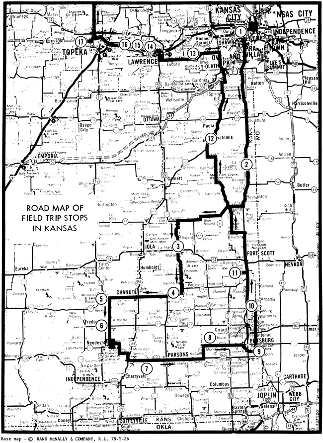
This stop shows a typical Kansas cyclothem in the open marine facies belt. The Iola is presently under doctoral study by Iowa student John Mitchell.
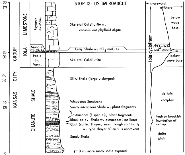
Chanute Shale with marine fossils nearby, records advance of prodeltaic clastics. Southward, thick sandstone and coal record delta-plain environment (Stop 12).
Paola Limestone is skeletal calcilutite with diverse biota recording algal carbonate mud production in quiet water below effective wave base but above base of the photic zone. It is traced 500 km with little change from Iowa to Oklahoma, a typical transgressive limestone at the base of the Iola cyclothem.
Muncie Creek Shale is the core shale of the Iola cyclothem. Black shale with phosphorite nodules records anoxic phosphate-rich bottom conditions developed under quasi-estuarine circulation with upwelling during maximum transgression. Gray shales above and below record bottom oxygenation developed as the quasi-estuarine cell was forming and as it was breaking up.
Raytown Limestone is the regressive limestone of the Iola cyclothem. The basal invertebrate calcarenite shows no cross-bedding or grain abrasion and lacks algal grains and micrite envelopes; only forams encrust the grains. This bed records accumulation of invertebrates in quiet water below effective wave base and probably below the effective limit of algal activity as well. The rest of the Raytown is skeletal calcilutite with conspicuous phylloid algae recording deposition in water shallow enough for algae, but still below effective wave base, even at the top. Shoalwater facies cap the Raytown locally in southeastern Kansas and Iowa.
Lane Shale records another advance of prodeltaic clastics into a quiet marine environment below effective wave base.
Leave Stop 1 at 8:10 A.M.
Drive 55 miles (E to I-635, S to US-69 and S 18 mi. past Louisburg) (70 min.) Wyandotte Ls. btw. 179th and 199th St. exits; Dennis Ls. S of Louisburg.
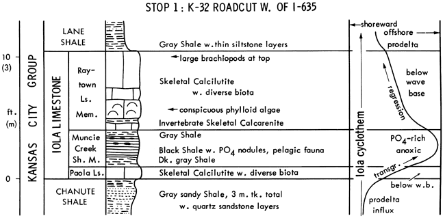
This stop shows the Swope cyclothem (studied by Mossler, 1973) in the open marine facies belt, a typical Kansas cyclothem like the Iola at Stop 1, but with distinct regressive shoal-water facies and a paleocaliche horizon at the top.
Ladore Shale is thin prodeltaic shale; sandstone and coal appear southward.
Middle Creek Limestone is a typical transgressive limestone at the base of the Swope from Nebraska (Stop 19) to southeastern Kansas, recording quiet water below effective wave base. Origin of dolomite at the top seems more related to associated shale than to supratidal or fresh-water mixing models.
Hushpuckney Shale is a typical core shale, with phosphatic black facies deposited under quasi-estuarine circulation during maximum transgression, and gray shale above deposited as the quasi-estuarine cell was breaking up.
Bethany Falls Limestone is distinctly regressive. Basal calcilutite records enough shallowing for algal carbonate mud production but not for coherent algal secretions. Upward appearance of algal blades in calcilutite suggests further shallowing within the photic zone but still below wave base. Overlying oolite with pellets and much mud matrix records shallowing to shoals with sediment mixing into associated quiet lagoons. Most ooids are now blocky calcite, probably from void filling after dissolution of aragonite, perhaps in the vadose zone. The thin laminated siliceous crust filling small karstlike pits in the oolite plus the overlying "rubbly" limestone, with poorly sorted, pelleted to vaguely pisolitic mud "clasts," displaying irregular accretionary layers on the outside, together represent a layer of paleocaliche that records subaerial exposure at the end of Swope regression.
Leave Stop 2 at 10:00 A.M.
Drive 51 miles (S on US-69 past Pleasanton, W on K-52 through Mound City, Blue Mound, Kincaid; S on US-59, 4.3 mi. past Mildred ) (65 min.). Swope cyclothem, little changed from Stop 2, is exposed in the roadcut past Mound City.
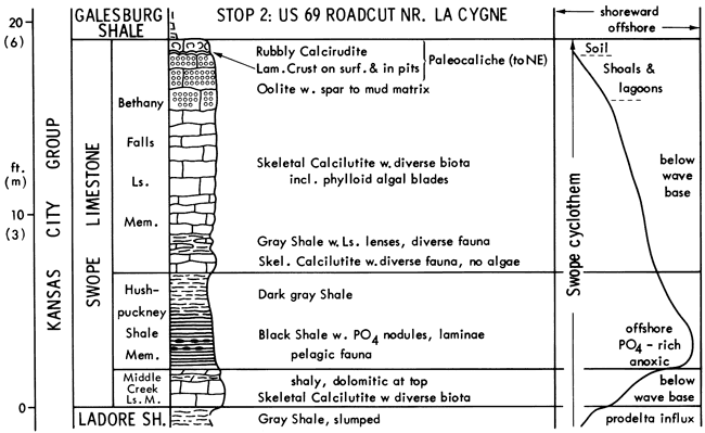
This stop shows the Iola cyclothem in the algal-mound facies belt.
Chanute Shale is reported about 21 m thick around here, with sandstone and coal (seen at Stop 12) recording a delta plain environment.
Paola Limestone remains skeletal calcilutite, a typical transgressive limestone little changed from Stop 1, 130 km north. At the base, however, thin skeletal calcarenite with abraded fossil debris displaying micrite envelopes records passage through zone above wave base early in the transgression. Scarcity of algae at the top suggests deepening to the lower limit of the photic zone.
Muncie Creek Shale is a thin gray shale with abundant phosphorite nodules and conodonts, and rare detrital quartz and macrobenthic fossils, all the characteristics of a core shale except the black anoxic facies. It records sediment starvation at maximum transgression, with phosphate-rich bottom water from the quasi-estuarine circulation cell, which here had not totally depleted bottom oxygen, possibly due to higher position of the entire Iola over the much thicker Chanute delta plain in this area compared to the thin prodeltaic Chanute at Stop 1.
Raytown Limestone still has the thin basal unabraded invertebrate calcarenite that probably records some shallowing with enough bottom reoxygenation for invertebrate proliferation short of the photic zone. Just above, phylloid algae become abundant enough to shelter spar-filled voids and form sparry algal calcilutite, characteristic of the algal-mound belt, which records shallowing into the photic zone short of wave base. Phylloid algae include red and green forms in which internal structure has been obliterated by neomorphism and/or dissolution--void-fill. A 1 by 10 m lens of "algal sparite" displays dull cloudy brown calcite crystals with bright rusty-weathering patches of ferroan dolomite that are darker at the base. Scattered buff patches of calcilutite in the sparite suggest initiation of this facies by lack of much mud deposition on the algal blades and other skeletal secretions. Relict radiating bundles of needle-like crystal ghosts within the calcite crystals suggest early precipitation of botryoidal aragonite spar that neomorphosed to irregular blocky calcite (Ravn and Heckel, 1978; Ravn et al., 1978). Remaining or newly formed voids became partly filled by geopetal material that eventually solidified to the small dolomite crystals in the darker basal portions, while the remaining tops of the voids became lined or filled with larger dolomite crystals to form the distinctive rusty-weathering patches. Largely algal sediment production was responsible for producing about 9 m of Raytown in this region, where nearby capping calcarenites record shoal water near the end of regression.
Leave Stop 3 at 11:30 A.M.
Drive 21 miles (S on US-59 through Moran, 2 mi past jct. with K-201 from Stark, pull left into driveway and park above road before bridge) (30 min.) Dennis Limestone exposed around Stark.
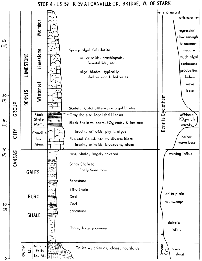
This stop shows the Dennis cyclothem in the algal-mound belt (studied by Frost, 1975), a coal-bearing "outside" shale (Galesburg), and an oolite shoal fauna (Swope).
Bethany Falls Limestone, the regressive member of the Swope cyclothem is capped by a cross-bedded spar-cemented oolite from here to about 40 km to the northeast. This represents the more agitated open marine shoal that protected the lagoon with the muddy oolite seen in the upper Bethany Falls at Stop 2, 90 km to the northeast. The oolite forms the bed of Canville Creek here, and at low water a pelecypod-dominated shoal-water fauna can be collected.
Galesburg Shale is an "outside" shale, which represents detrital influx that terminated the Swope cyclothem. It probably records aggradation of a deltaic plain that underwent at least two stages of coal swamp development punctuated by perhaps flood-borne detrital influx in this region. Northward the Galesburg thins to about 1 m of shale around Kansas City, and southward it thickens to about 21 m with increasing prominence of sandstones, which have been described by Stobbe (1971). Petrology of the entire Galesburg as well as the Stark Shale above is presently under doctoral study by Iowa student Steve Schutter.
Canville Limestone is the transgressive limestone of the Dennis cyclothem. Essentially confined to southeastern Kansas where underlying Galesburg Shale and Bethany Falls Limestone are thickest, the Canville is less widespread than other transgressive limestones perhaps partly because of too rapid deepening through the critical depths for algal carbonate production over the thin underlying shale in northeastern Kansas. In this region, however, the Canville thickens locally to 2.4 m through addition of algal-rich calcilutite above the basal skeletal calcilutite. Seen as the upper 0.6 m here, this thickens eastward along US-59 to about 2 m and represents a small transgressive algal mound developed on this presumably higher area over thicker underlying units as transgression slowed a little.
Stark Shale is the core shale of the Dennis cyclothem with the typical black phosphatic facies recording quasi-estuarine circulation at maximum transgression like the black shales in the Iola and Swope cyclothems at Stops I and 2. Because the Stark d 4 splays this black phosphatic facies continuously from Iowa to southern Kansas, it was not affected by higher bottom topography over thicker underlying formations, as the underlying Canville Limestone here or the core shale of the Iola cyclothem at Stop 3 apparently were; thus it may represent a more extensive transgression with greater water depths on a regional scale. Local accumulation of whole shells at the top records patchy reestablishment of invertebrates as substantial bottom oxygen returned.
Winterset Limestone is a thick regressive limestone only half exposed here. Basal calcilutite with no algal blades records shallowing into the effective photic zone for only mud-producing algae; coherent blade production apparently required slightly shallower water. Thick development of sparry algal calcilutite records substantial proliferation of large phylloid algal blades below effective wave base during a relatively slow regression. Shallowing above wave base is recorded in a cross-bedded oolite, which is exposed nearby above the level of this roadcut.
Leave Stop 4 at 1:00 P.M.
Drive 27 miles (W on K-39 through Chanute, 1.6 mi past jct. with US-75; park in lane on right after crossing spillway bridge) (35 min). Dennis Ls. exposed on way to Chanute, Iola Ls. on W side of Chanute, Stanton Ls. 6 mi farther west. Unload bus in lane W of spillway bridge; walk S down spillway (10 min.).
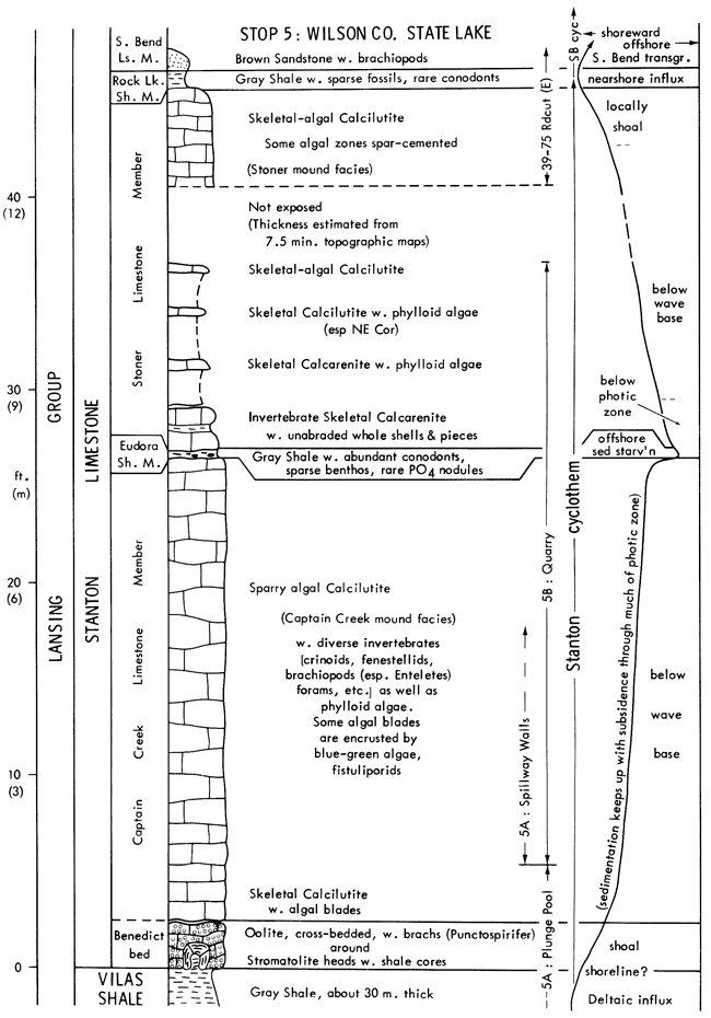
This stop shows the best transgressive calcarenite and thickest transgressive phylloid algal mound in the Kansas Pennsylvanian. The Stanton Limestone, which consists of a complete cyclothem (Stanton) overlain by another (South Bend) only partly developed in Kansas, is the most intensively studied Missourian unit in Kansas (Heckel, 1975, 1975a, 1978; Senich, 1975, 1978; Wood, 1977; Wood and Heckel, 1977; also M.D. Brondos, in prep. on ostracodes and forams; S.R. Schutter, in prep. on shale petrology; R. Moussavi-Harami, in prep. on associated sandstones).
Vilas Shale records a detrital complex building westward with the final slope preserved beneath the northwestern flank of the Stanton buildup, 3 km away.
Benedict bed consists of spar-cemented oolite surrounding large shale-cored stromatolite heads; oolite disappears eastward, and stromatolites disappear westward. Though no definite algae are apparent in thin section, stromatolites carry encrusting forams and a few brachiopods and snails, and probably represent algal mat development during initial marine inundation of the Vilas platform. Oolite records the zone of agitated water along the northwest edge of the stromatolitic platform during early transgression. Ooids display ghost lamellar structure in blocky calcite crystals, thus record direct inversion from aragonite in the transgressive environment where subaerial dissolution never occurred.
Captain Creek Limestone (with Benedict bed) is the transgressive limestone of the Stanton cyclothem. It is sparry algal calcilutite with a diverse marine biota dominated by blades of phylloid algae that often shelter spar-filled voids with geopetal sediment in the base. This "algal-mound facies" records quiet water below wave base but above the effective photic limit for this kind of algae.
Leave Stop 5A at 2:20 P.M.
Walk 0.5 mile up spillway and E below highway level to quarry (15 min).
This stop shows offshore facies of the Stanton cyclothem in the algal mound facies belt, from the upper part of the transgressive limestone through the base of the regressive limestone, which is shaly enough for good fossil collecting.
Captain Creek is typical algal mound facies throughout its entire 7.5 m thickness, which records transgression slow enough for more algal blade and mud production within the photic zone than during any other inundation in Kansas.
Eudora Shale, thin and gray with abundant diverse conodonts typical of other core shales, scattered benthic invertebrates and rare phosphate nodules, records sediment starvation at maximum transgression with quasi-estuarine circulation and upwelling above the level of anoxic bottom water, which was confined in this facies belt to topographically low channels where the transgressive limestone is thin and the Eudora is black (Stop 6B). Black phosphatic facies is widespread in the Eudora above thin Captain Creek north of the algal mound facies belt (Stops 13, 20).
Stoner Limestone is the regressive limestone of the Stanton cyclothem. Basal invertebrate calcarenite with no cross-bedding, grain abrasion, or evidence of algae records enough shallowing and bottom oxygenation for invertebrate proliferation. First appearance of phylloid algae at 1.2 m above the base, suggests further shallowing above base of photic limit for these algae. The top of the Stoner exposed in K-39/US-75 roadcut just to the east has abundant algae, some in spar-cemented zones, suggesting further shallowing to wave base.
Leave Stop 5B at 3:05 P.M. to meet bus across highway by 3:15 P.M.
Drive 17 miles (E and S on US-75 to Altoona, W on K-47 across river, then 1st N, 1st W and S on gravel roads) (25 min.).
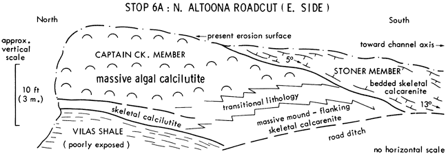
This stop shows facies change from Captain Creek algal mound into flanking calcarenite along north side of contemporaneous channel in Stanton Limestone.
Captain Creek algal mound facies dips and thins southward to disappearance toward the channel axis while basal skeletal calcilutite grades to mound-flank calcarenite, which thickens complementarily. As Captain Creek mound facies grew vertically in response to water deepening, it extended laterally very little into the channel. Mound-flank calcarenite contains calcilutite "clasts" derived from tops of algal blades in the mound facies. Stoner muddy calcarenite overlies a thin tongue of mound facies in the middle of the cut and also dips southward toward the channel axis. Eudora Shale was probably not deposited here because of slow currents in deep water impinging on the prominent edge of the mound.
Carbonate channel facies lie at least 24 m below equivalent mound facies on either side (see map below). Averaging 1 km wide, the channel is traced from linear outliers northeast of Altoona westward 36 km where it forms a noticeable topographic low in the main outcrop belt. Most channel fill is Stoner calcarenite, but regressive reddish Rock Lake quartz sandstone (exposed on way to Stop 6B), and gray South Bend fossiliferous quartz sandstone and sandy calcilutite of the succeeding transgression overlie the Stoner along the channel axis.
Leave Stop 6A at 4:00 P.M.
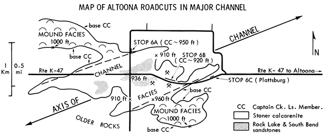
Drive 1 mile (S, then E on K-47; park at quarry entrance on right) (10 min.) Reddish Rock Lake sandstone on left at junction.
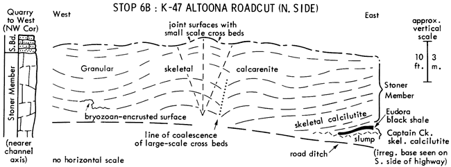
This stop shows Stanton channel facies near the axis of the channel.
Captain Creek is thin skeletal calcilutite in which diverse marine fauna and lack of Vilas clasts record deposition in quiet water below effective wave base. This suggests that the initial Stanton carbonate deposit merely conformed to preexisting channelled topography on the Vilas surface after terrigenous influx ceased in a continually subaqueous environment as sea water encroached into a formerly fresh- or brackish-water channel.
Thin black Eudora Shale records greatly reduced deposition of the finest suspended material in an anoxic bottom environment developed in the deepest water of the channel axis at maximum transgression. Black color disappears as the shale rises 3 m across the highway toward the south side of channel, which remained continually above the anoxic water layer.
Stoner Member, forming most of the channel fill, is skeletal calcilutite at the base recording resumption of carbonate deposition in relatively deep quiet water after anoxic bottom conditions disappeared during early regression. Upper Stoner is spar-cemented abraded-grain calcarenite, which records the increasingly well-washed environment developed in the channel as further shallowing caused currents to funnel along the channel and impinge upon the bottom. Many abraded grains have micrite envelopes and some are coated. The brownish grains are ferroan dolomite, probably void filling after grain dissolution. Distinctive large-scale cross-bedding, in which uparched beds coalesce laterally at the edges, probably represents cross sections of elongate lime-sand bars, parallel to the sides of the channel, which accreted upward through time with little movement toward the sides of the channel. Small-scale cross-bedding locally shows bidirectional transport of tidal currents. Many organisms present as whole fossils (certain brachiopods [Schizophoria], bryozoans [Meekoporella], snails, corals) probably lived in the channel. Articulated crinoid stems suggest rapid burial by a thick layer of debris during storms. The bryozoan-encrusted irregular surface indicates intermittency of deposition and periods of erosion.
The quarry to the west exposes lenses of overlying Rock Lake sandstone and 1.5 m of South Bend interbedded fossiliferous quartz sandstone and sandy calcilutite recording later channel fill that was reworked in the succeeding transgression, which initiated the South Bend cyclothem.
Leave Stop 6B at 5:10 P.M.
Walk 0.4 mile E along N side of K-47, partway down hill (10 min.).
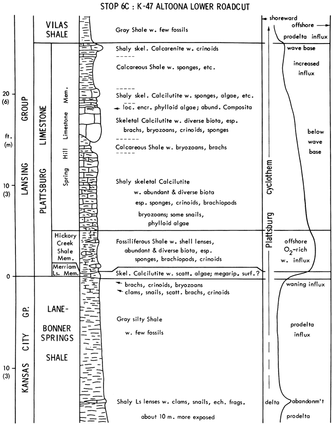
This stop shows offmound facies of the Plattsburg cyclothem, which lacks black phosphatic facies in the core shale and contains shaly limestones and fossiliferous shales that yield abundant fossils.
Lane-Bonner Springs Shale is an "outside" shale about 50 m thick, formed by coalescence of Lane and Bonner Springs Shales south of disappearance of the Wyandotte Limestone about 100 km northeast. It is not known if any zones of marine fossils in the Lane-Bonner Springs are continuous enough to represent the Wyandotte cyclothem. Here, the Lane-Bonner Springs records prodeltaic detrital influx during regression, which waned abruptly through delta abandonment before transgression, allowing accumulation of enough shells to form a regional zone of shaly limestone lenses in the upper part. The assemblage of clams, snails and crinoid fragments represents a marine fauna dominated by organisms adapted to soft substrate and relatively turbid water (see Heckel, 1975a, p. 35). Above these lenses, later shift of prodelta influx back into this region formed the upper 4 m of this shale. Waning of this influx established first the "turbid-water" molluscan fauna, then a clear-water fauna at the top, containing bryozoans and more brachiopods and crinoids than below.
Merriam Limestone is the transgressive limestone of the Plattsburg cyclothem, deposited when algae produced enough carbonate mud to form a shaly calcilutite. The Merriam is lenticular and appears developed on a megarippled surface, which suggests enough current activity to produce bedforms on the underlying shale surface and to prevent even distribution of lime mud, but not enough to winnow sufficient mud to form a calcarenite.
Hickory Creek Shale is the core shale of the Plattsburg cyclothem. It was deposited far enough offshore for stable marine salinity, but not in water deep enough for establishment of the quasi-estuarine circulation cell that led to phosphorite deposition and loss of bottom oxygen in other cycles. Suppression of carbonate production probably was due to position low in the photic zone; even if fine detrital influx helped subdue algal growth above the effective base of the photic zone, influx was low enough to allow establishment of a good filter-feeding fauna.
Spring Hill Limestone is the regressive limestone of the Plattsburg. Its more pervasive shaliness than most other regressive limestones suggests a more persistent detrital source, which apparently remained closer to the present outcrop because less water depth was attained during the Plattsburg transgression. Local proliferation of encrusting phylloid algae in the upper part is the only indication here that the north end of one of the thickest (25m) algal-mound complexes in the Kansas Pennsylvanian, equivalent to the upper half of the Spring Hill but extending in thickness up to the base of the Stanton, lies about 3 km to the southwest (Harbaugh, 1959, 1962, et al. 1965; also Nelson, 1978). Following increase in detrital influx, the calcarenite at the top here records passage of the zone of wave agitation during regression.
Vilas Shale records another prodeltaic detrital influx that ended Plattsburg deposition here and filled.in around the north end of the Plattsburg mound.
Leave Stop 6C at 6:00 P.M.
Drive 9 miles (E on K-47, S on US-75, 7 miles) (15 min.). Chanute sandstone exposed S of Altoona.
Dinner about 7:15 P.M. and overnight at Old Homestead Motel, US-75 N, Neodesha, Ks.
Drive 18 miles (E on K-37; E on US-160, 6 mi past US-169 and S 0.3 mi) (25 min)
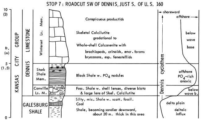
This stop shows the Dennis cyclothem south of the algal mound belt, where it displays transition of characteristics between Kansas and Illinois cyclothems.
Galesburg Shale records delta plain aggradation with coal swamp formation.
Canville Limestone records transgression with waning of detrital influx, increase in invertebrates to form small shell lenses, and localized proliferation of carbonate-mud-producing algae to form calcilutite lenses. Lack of widespread algae may relate to inhibition by 1) insufficient waning of detrital influx until water depth was too great, or by 2) proximity of buried peat to substrate.
Stark Shale records quasi-estuarine circulation at maximum transgression.
Winterset Limestone records enough regression to destroy the quasi-estuarine cell and reoxygenate the sea bottom for reestablishment of an abundant invertebrate fauna. Scarcity of algae suggests that greater water depths may have been maintained here for a longer time than in the algal mound facies belt to the north, perhaps because of greater subsidence south of a hinge line.
The vertical sequence through the Canville skeletal calcilutite lens is a typical Kansas cyclothem as seen at Stops 1, 2 and 4, whereas the vertical sequence through the shaly Canville is a typical Illinois cyclothem with only a thin shelly marine shale between the coal and the black shale. Their lateral transition along a single exposure shows the close genetic similarity between Kansas and Illinois cyclothems that contain phosphatic black shales; only the presence or absence of a conspicuous transgressive limestone differentiates them.
Leave Stop 7 at 8:30 A.M.
Drive 35 miles (N to US-160, E through Parsons, left at McCune on K-126, 5 mi N, 4 mi E, then left before bridge on gravel road, 2 miles) (45 min.)
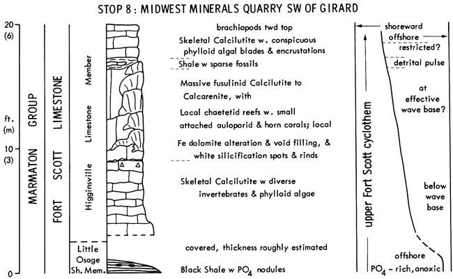
This stop shows chaetetid reefs in the Higginsville Member of the Fort Scott Limestone, lowest formation of the Marmaton Group. The Marmaton forms the top of the Desmoinesian Stage and Middle Pennsylvanian Series in Kansas. Chaetetids are unknown in Upper Pennsylvanian rocks in the Midcontinent.
Little Osage Shale is exposed in a drainage area northeast of the lane into the quarry. Black phosphatic shale facies records maximum transgression of the upper Fort Scott cyclothem; lacking a transgressive limestone, this is an Illinois-type cyclothem. Known only from borings here, the Blackjack Creek limestone at the base of the Fort Scott and the underlying Excello black phosphatic shale form the lower Fort Scott cyclothem, also of the Illinois type, in this region.
Higginsville Limestone, forming the quarry walls west along the lane, is the regressive limestone of the upper Fort Scott. Skeletal calcilutite at the base records reoxygenated bottom below effective wave base but within the photic zone. The massive zone in the middle records localized proliferation of chaetetids to form reefs up to 2.4 m thick and 3.0 m across, but with perhaps less than 0.5 m of relief at any one time. These reefs provided substrate for attachment of auloporid and horn corals. Diagenetic alteration of reefs includes local replacement by silica and filling of fractures by ferroan dolomite. Inter-reef areas underwent proliferation of fusulinids with evidence of agitated water in sparry cement in the middle. Thin sparsely fossiliferous shale above suggests a rapid detrital pulse that smothered the reefs. Skeletal calcilutite at the top records proliferation of phylloid algae in a quiet muddy environment, possibly a restricted lagoon in view of lower biotic diversity; nature of overlying beds is unknown.
Leave Stop 8 at 10:00 A.M.
Drive 19 miles (S to K-126, E to US-69, S 2.3 miles, E 2.7 miles on Centennial St.) (30 min.)
This stop shows elements of cyclic sequences in the,lower Cherokee Group, including coals and lenticular sandstones, but lacking black phosphatic shales.
Walk 0.25 mile N, and turn back S on ramp into strip-pit. (10 min.)
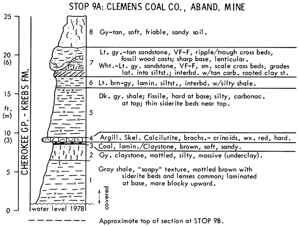
Sandstones in Lower Cherokee cyclothems probably were deposited in shallow-water deltas (Ebanks, et al. 1977). The various phases of these cyclothems can be interpreted best as facies of alluvial-deltaic complexes. This calls for a revision of thinking about continuity of sandstones in the lower Cherokee (see article later in guidebook), and about the best idealized cyclic sequence describing the Cherokee type of cyclothem. The repetitive occurrence of various lithologies is the product of delta-shifting and distributary abandonment, with slow subsidence but without significant eustatic sea level change. In this setting, coals are the "normal" culmination of aggrading sedimentation on delta plains, whereas sandstones are more sporadic and less predictable in occurrence. Some sandstones of alluvial or distributary origin cut through earlier flood-plain or delta-fringe sediments, as thin delta sequences prograded rapidly in shallow water without building thick shale wedges ahead of them. Thus, most "unconformities" noted by earlier workers are no more than local channel scours. In contrast to the type of cyclothem developed during eustatic sea level change, with the deposit formed at maximum transgression at its middle (Fig. 3A), the idealized sequence of genetically related lithologies in these more common Cherokee cyclothems reflects progradation of a clastic wedge (in upward sequence): dark marine shale with rare limestone-gray sideritic shale-gray silty shale with thin sandstone interbeds-rare cross-bedded sandstone-thin-bedded sandstone, siltstone and shale-underclay with coal.
Leave Stop 9A at 11:10 A.M. to meet bus at 11:20 A.M.
Drive 0.7 mile E; walk 0.25 mile N into strip-pit. (15 min.)
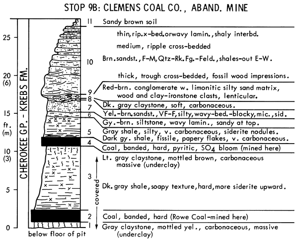
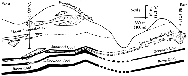
This east-west cross section illustrating relationships of Stops 9A and 9B is based on borings about 100 m apart and pre-mining topographic maps. The dip of Cherokee beds in this area averages 15-20 ft/mi (3-4 m/km). The sandstones high in the section are probably equivalent to the Bluejacket Sandstone, which occurs discontinuously at the surface in this area of Kansas and in adjoining states.
Leave Stop 9B at 12:05 P.M. to meet bus at 12:15 P.M.
Drive 9 miles (1 mile E, 7 miles N, 0.7 mile W) (15 min.)
Lunch at Chicken Mary's, Yale, Kansas (60 min.)
Drive 11 miles (0.3 mile W, 2 miles N, 1 mile W, 7 miles N, 0.7 mile into mine area; depending on mine conditions, there can be a short walk of up to 0.2 mile) (20 min.)
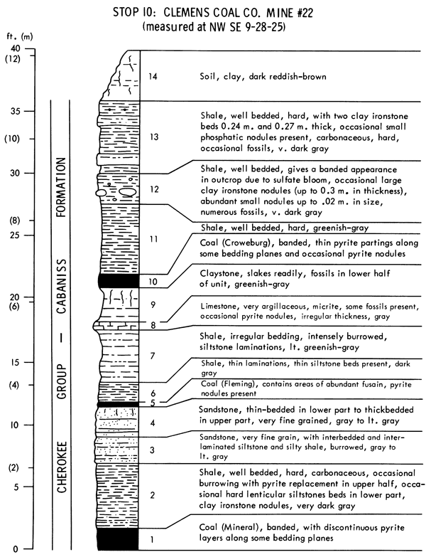
The mine at this stop is the third largest coal mine operating in Kansas with an annual production of approximately 200,000 tons of coal. A more comprehensive description of Kansas coal production appears in a later article in this guidebook.
Variation in stratigraphy and height of the highwall cut make this particular mine an interesting stop to observe the rock units in the upper part of the Cherokee Group. The Mineral and Croweburg coals are mined at this location in a multiple-bed operation. The Bevier coal is also mined where present, if the quality has not deteriorated from surface weathering. Total thickness of the Cabaniss Formation is approximately 60 m in a total Cherokee Group thickness of approximately 115 m.
By utilizing a shovel and dragline, multiple coal beds are worked, and a continuing reclamation effort is maintained. Mining equipment used at the mine includes a 23-yard Marion 5560 shovel and an 11-yard Marion 7400 dragline as well as bulldozers, loaders, trucks, and scrapers, All the coal mined is processed through the company tipple located 4 km (2.5 miles) southeast of this location.
Channel samples taken of the Croweburg and Mineral coals from this mine show the following general values:
| Croweburg | Mineral | |
|---|---|---|
| Heat of Combustion | 28,000 kJ/kg | 29,300 kJ/kg |
| 12,000 BTU | 12,600 BTU | |
| Ash | 16% | 13% |
| Sulfur | 4% | 4-5% |
| Volatile | 37% | 36% |
| Fixed Carbon | 45% | 48% |
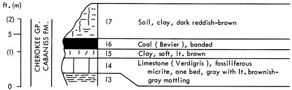
The above section, measured in the NW sec. 15, 0.9 mile (1.5 km) southeast of the section visited in the mine (opposite page), shows the rock sequence present above the shale of unit 13. The Verdigris Limestone (unit 14) and underlying phosphatic shale (unit 13, here and at Stop 10) have been traced laterally for several hundred km from Oklahoma to Missouri. They may represent part of a major eustatic Cherokee cyclothem rather than a simple delta-abandonment cycle, which seems to be the dominant type in the Cherokee Group.
Leave Stop 10 at 3:05 P.M.
Drive 20 miles (W nearly 2 miles to US-69, N 12 miles, W on paved road 4 miles, then S 1 mile and W 0.6 mile) (30 min.)
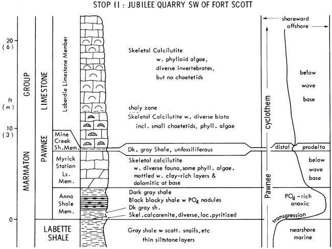
This stop shows the Pawnee Limestone, a Middle Pennsylvanian cyclothem of the Illinois type, which lacks a well developed transgressive limestone. The Pawnee is presently under doctoral investigation by Iowa student Rex Price who provided most of the following information.
Labette Shale is the outside shale separating the Fort Scott and Pawnee Limestones. Averaging about 12 m thick in Kansas, it contains local coals and sandstones with scattered zones of marine fossils; thus it probably represents a spectrum of delta plain to nearshore marine environments. The top meter exposed in this quarry,with scattered marine invertebrates, burrows and trails, records detrital influx in a turbid nearshore regime, perhaps from a nearby delta lobe.
Anna Shale is included in the Pawnee Limestone because of the thin lenticular limestone that is present in places at its base. Here this is a thin, slightly sandy,skeletal calcarenite that records local proliferation of invertebrates as detrital influx waned during transgression. Pyritization of parts of it probably relates to early-burial diagenesis. The dark gray shale just above with few benthic fossils records reduced bottom oxygenation with further transgression. The black shale with phosphorite nodules in the middle records phosphate-rich anoxic bottom conditions developed under strong quasi-estuarine circulation at maximum transgression. Phosphorite nodules in the Anna contain well preserved radiolarians (Berendsen and Nodine-Zeller, 1978); these represent a pelagic fauna, which would be expected in such nutrient-rich waters, but they are either not yet discovered or not preserved in other phosphatic black shales. The possibly greater silica content from radiolarians in the surrounding shale may account for the blockiness and lesser fissility of the Anna compared to other black shales. The upper dark gray shale records lessening effect of the quasi-estuarine cell.
Myrick Station Limestone is the early regressive limestone of the Pawnee cyclothem, in which diversely fossiliferous skeletal calcilutite with scattered. phylloid algae records reestablishment of good bottom oxygenation below effective wave base but within the lower part of the photic zone. Dolomitization of the calcilutite matrix, which is pervasive in stained thin sections from the base of the unit, probably is related more to the associated offshore shale, just as in the top of the transgressive limestone at Stop 2, than to supratidal or fresh-water mixing models.
Mine Creek Shale is little more than an unfossiliferous shale parting in the thick limestone sequence here, and records the distal end of a rapid pulse of detrital influx. It has been traced about 35 km northeastward into a 5-m thick shale, which represents the main delta lobe penetrating a relatively offshore carbonate environment in the middle stage of regression.
Laberdie Limestone is the remainder of the regressive limestone of the Pawnee cyclothem, in which diversely fossiliferous skeletal calcilutite with upward increasing phylloid algae records shallowing within the photic zone short of effective wave base. The chaetetids in the lower Laberdie are thin, laterally extensive encrusting forms, which seem to be adapted to a more offshore quiet-water environment than the massive domal forms that built small reefs in the Fort Scott at Stop 8. Abundant monocrystalline and polycrystalline calcispheres are noted in thin section in the more algal horizons in the middle and upper Laberdie; their possible dasyclad algal origin is compatible with an upward shallowing sequence. The top of the Laberdie is not exposed here, so it is not known whether the Pawnee has regressive shoal-water carbonate facies or not.
Leave Stop 11 at 4:25 P.M.
Drive 65 miles (E 0.6 mile, N 1 mile, E 4 miles back to US-69; N through Ft. Scott 15 miles to K-31 at Fulton, W 5.5 miles to K-7, N about 36 miles through Mound City to US-169, then N 3 miles across bridge over Marais des Cygnes River) (85 min.); the Bronson escarpment of 3 lower Kansas City Group limestones [Hertha, Swope, Dennis] is crossed several times around Mound City.
This stop shows the Missourian outside shale that contains the most widespread coal horizon in eastern Kansas; the coal here is overlain by a thin black shale that is different from the offshore phosphatic black shales associated with the marine parts of cyclothems (see Heckel and Swade, 1977).
Chanute Shale is at least 10 m thick here where it represents delta plain aggradation with coal swamp development, compared to the 3 m of prodeltaic facies at Stop 1, 65 km to the north. Above the coal here are several cm of black shale, which carries ostracodes, molluscs and wood fragments, but no conodonts, thus probably records a low-oxygen fresh-water lake or slightly brackish-water lagoon developed over an inundated coal swamp.
Iola Limestone is the overlying complete transgressive-regressive marine sequence little different from Stops 1 and 3, 65 to 85 km north and south.
Leave Stop 12 at 6:10 P.M.
Drive 52 miles (N on US-169, to K-7 through Olathe, and W on K-10 to Lawrence; several upper Missourian limestones are exposed along the way) (60 min.)
Dinner about 7:30 and overnight at a motel in Lawrence, Kansas.
Drive 15 miles (E on K-10 to exit ramp 1 mi E of Evening Star Rd exit)(25 min)
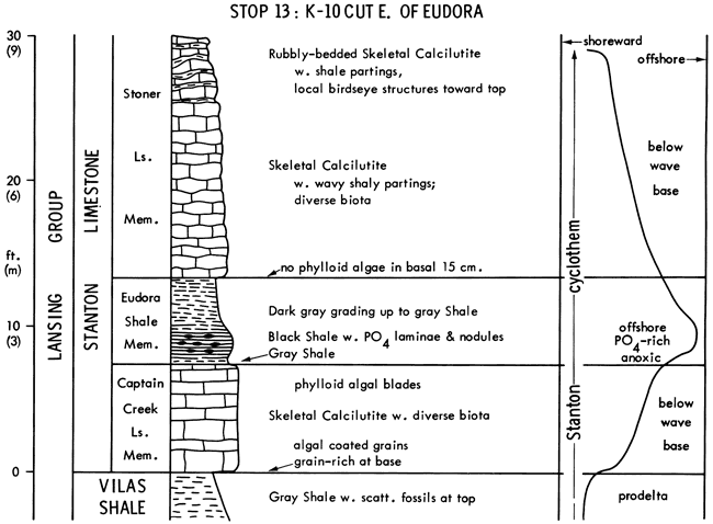
This stop shows the Stanton Limestone (seen 170 km south in the algal mound belt at Stops 5 and 6), developed as a typical Kansas cyclothem in the open marine facies belt at a new roadcut where the phosphatic black shale is well exposed.
Vilas Shale records prodeltaic detrital influx.
Captain Creek Limestone records waning of detrital influx and establishment of algal carbonate mud production during a transgression slow enough to develop the thickest transgressive limestone in the Upper Pennsylvanian of Kansas.
Eudora Shale records enough water deepening to establish quasi-estuarine circulation, upwelling and phosphate-rich anoxic bottom conditions. The Eudora black shale facies is developed wherever the Captain Creek is less than 4 m thick, and is continuous for 370 km from east central Kansas to Nebraska (Stop 20).
Stoner Limestone records resumption of algal carbonate mud production at the base, followed 15 cm above by appearance of coherent secretions of phylloid algae. Shallowing at the top is indicated by birdseye structures in less fossiliferous calcilutite, and possibly also by increased shaliness from encroaching detrital lobes. Fine-grained abraded skeletal calcarenite is present at the top of the Stoner 16 km to the northeast along the Kansas Turnpike.
Leave Stop 13 at 8:30 A.M.
Drive 21 miles (W on K-10 to Lawrence, N on US-59 into W. Lawrence Turnpike Interchange, and W on Kansas Turnpike [I-70] 3 miles) (30 min.)
This stop shows most of the Oread Limestone, which is perhaps the archetypical "Shawnee Megacyclothem," the most complex of R.C. Moore's cyclic sequences.
Lawrence Shale here represents a delta-plain deposit with short-lived coal swamp development followed by marginal marine detrital influx (Hakes, 1977) before delta abandonment at the top.
Toronto Limestone is the "lower" limestone of the Oread "megacyclothem." Detailed study by Troell (1965, 1969) suggests that it represents a single transgressive-regressive fluctuation of sea level. In this exposure, transgression is recorded by passage upward from the thin basal shell concentration into skeletal calcilutite deposited between effective wave base and base of the photic zone. The thin fossiliferous shale near the middle is widespread enough to have been used as the major stratigraphic datum by Troell (1965), who interpreted it as a product of very slow offshore clay deposition in view of its fauna of filter feeders (bryozoans, corals, crinoids), which would not have developed in a rapid turbid nearshore detrital pulse. It is possible that scarcity of carbonate mud at this horizon reflects lack of algae near the base of the photic zone, and in view of the relative abundance of conodonts (about 100/kg,mostly idiognathodids), this shale represents the core shale deposited at maximum transgression of the Toronto cyclothem. Regression is recorded by passage from the overlying skeletal calcilutite into the capping argillaceous calcilutite with low-diversity fauna of euryhaline groups, which may represent a restricted lagoonal environment.
Snyderville Shale records spread of detritus in an alluvial environment followed by initial inundation of the succeeding transgression.
Leavenworth Limestone is the "middle" limestone of the Oread megacyclothem and the transgressive limestone of the Oread cyclothem. Detailed study by Toomey (1969) documents the lateral persistence of its nearly uniform nature 500 km from Iowa to Oklahoma. It records a blanket of algal mud production during transgression between effective wave base and the base of the photic zone.
Heebner Shale is the core shale of the Oread cyclothem. Detailed study by Evans (1967) was among the first to strongly propose interpretation of this type of black shale as the deepest-water phase of the megacyclothem. It records depths great enough to establish quasi-estuarine circulation and upwelling, followed by enough shallowing to cause the quasi-estuarine cell to break up and allow some bottom reoxygenation below the effective base of algal mud production.
Plattsmouth Limestone is the "upper" limestone of the Oread megacyclothem and early regressive limestone of the Oread cyclothem., It records enough shallowing to thoroughly reoxygenate the sea bottom and reestablish algal mud production. Calcilutite with diverse biota throughout indicates deposition entirely below wave base.
Heumader Shale records a rapid detrital pulse in view of its sparse fauna.
Kereford Limestone is the "super" limestone of the Oread megacyclothem and probably the late regressive limestone of the Oread cyclothem separated from the early regressive limestone by a fortuitous detrital wedge. Here, its base records resumption of algal mud production below wave base, but laterally, oolites and molluscan biotas record shoaling above wave base and perhaps lagoon formation.
Leave Stop 14 at 10:00 A.M.
Drive 2.6 miles W along Kansas Turnpike (I-70) (10 min.).
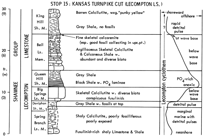
This stop shows the middle of the Lecompton Limestone, the next higher "Shawnee megacyclothem," differing from the others in extreme shaliness of the regressive limestone, which affords excellent fossil collecting.
Spring Branch Limestone, the "lower" limestone, may record only reduced detrital influx in a nearshore marine environment during general regression.
Doniphan Shale records more overwhelming detrital influx into a marginal marine environment, followed by initiation of the succeeding major transgression.
Big Springs Limestone, the "middle" limestone of the Lecompton megacyclothem and transgressive limestone of the Lecompton cyclothem, records algal mud production and fusulinid proliferation between wave base and base of the photic zone.
Queen Hill Shale is the core shale of the Lecompton cyclothem, which records quasi-estuarine circulation at maximum transgression.
Beil Limestone is the "upper" limestone of the Lecompton megacyclothem and regressive limestone of the Lecompton cyclothem. It records algal mud production and invertebrate proliferation on a sea floor that was subject to more detrital influx from distant deltas than were most other regressive limestones. Fine calcarenite in the topmost bed records regression above effective wave base.
King Hill Shale records more overwhelming detrital influx from a closer delta as shoreline approached. Environment of the yellow carbonate is not clear.
"Super" limestone of the Lecompton megacyclothem (Avoca) is not exposed here.
Leave Stop 15 at 11:00 A.M.
Drive 2 miles W along Kansas Turnpike (I-70) (10 min.).
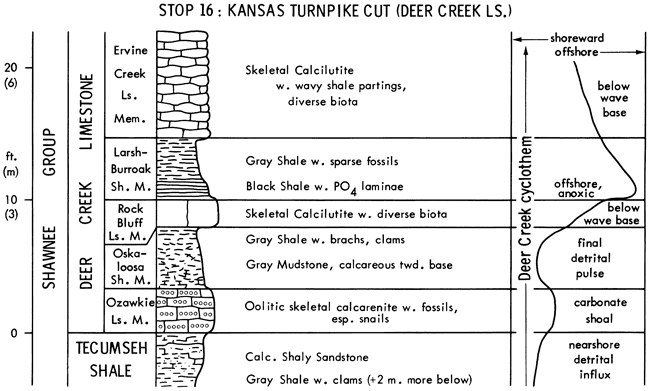
This stop shows most of the Deer Creek Limestone, the next higher "Shawnee megacyclothem," and the highest that is well developed from Iowa to Oklahoma.
Tecumseh Shale records detrital influx into a shallow nearshore environment, in which transgression initiating Deer Creek deposition can be detected by vertical sequence of trace fossils toward the top (Hakes, 1976).
Ozawkie Limestone is the "lower" limestone of the Deer Creek megacyclothem. Entirely oolitic here, it records an agitated carbonate shoal, which requires no significant change in sea level. Like the Spring Branch ("lower" limestone of the Lecompton) it is absent in Nebraska (Moore, 1949), thus supporting possible origin of both from delta shifting near the end of regression, rather than from widespread sea level change as suggested for the Toronto ("lower" limestone of the Oread), which is as well developed in Nebraska as in Kansas.
Oskaloosa Shale records the last detrital pulse before major transgression.
Rock Bluff Limestone is the "middle" limestone of the Deer Creek megacyclothem and transgressive limestone of the Deer Creek cyclothem, recording algal mud production between effective wave base and base of the photic zone.
Larsh-Burroak Shale is the core shale of the Deer Creek cyclothem, recording quasi-estuarine circulation at maximum transgression. It has been considered equivalent to two thin shales and a intervening limestone in Nebraska (Stop 22).
Ervine Creek Limestone is the "upper" limestone of the Deer Creek megacyclothem and regressive limestone of the Deer Creek cyclothem, recording reestablishment of algal mud production. Although not exposed here, the top is oolitic in places (Moore, 1949), recording shallowing above wave base.
Leave Stop 16 at 11:40 A.M.
Drive about 23 miles (W on Kansas Turnpike, staying on I-70 through Topeka to about 11 miles W of E. Topeka Turnpike Interchange, and 0.6 mile W of on-ramp joining I-470 with I-70); includes Lunch Stop around Topeka (90 min.); Topeka Limestone exposed on E side of Topeka.
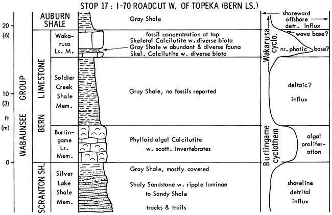
This stop shows two Wabaunsee Group limestones. One displays several members of Moore's (1936) Wabaunsee cyclothem, which form a miniature Kansas cyclothem and can be similarly interpreted. Limestone formations presently recognized in the Wabaunsee Group (e.g. Bern) consist of two distinct limestone cycles separated by a shale member that is lithically like the adjacent shale formations.
Silver Lake Shale records detrital influx into a shoreline environment.
Burlingame Limestone is traced from Nebraska to Oklahoma and displays elements of the Wabaunsee cyclothem in places, though unequally developed (Moore, 1949); thus it may represent a widespread eustatic transgression. Nevertheless, its uniform algal calcilutite lithology in this exposure definitely records only cessation of detrital influx and proliferation of phylloid algae, which could result merely from delta abandonment in the nearshore marine environment.
Soldier Creek Shale records another overwhelming, perhaps deltaic, influx.
Wakarusa Limestone comprises two beds of limestone separated by a thin shale and thereby constitutes a miniature Kansas cyclothem. The limestone is recognized from Nebraska to Oklahoma, and the thin shale is traceable at least from Topeka (Owen, 1959) to Nebraska (Burchett and Reed, 1967, p. 41). At this exposure, the thin basal limestone records transgression between effective wave base and base of the photic zone. The thin shale, in view of its abundant and diverse fossil content (including hundreds of conodonts/kg,.dominated by idiognathodids and containing possible idioprioniodid elements), records slow offshore settling of suspended detritus and cessation of algal mud production near the base of the photic zone, rather than nearshore rapid detrital influx. The thicker upper limestone records shallowing through the main part of the photic zone, and the shell concentration at the top may reflect winnowing of mud above wave base, although little abrasion is apparent. The thin shale in the middle is a typical core shale developed in water too shallow to establish a quasi-estuarine circulation cell, and it corresponds to the .4 shale of Moore's typical Wabaunsee cyclothem. The thick limestone above contains fusulinids and lithically resembles Moore's .5 limestone, while the shelly horizon at the top might be considered the .7 limestone. The basal limestone, although lithically resembling the .3 limestone, carries more abundant fusulinids than the .5 limestone, which suggests that presence or absence of fusulinids is not as significant a characteristic as Moore (1936) believed in his interpretation of Wabaunsee and Shawnee sequences.
Auburn Shale records return of rapid detrital influx, during the regression that terminated the Wakarusa cyclothem.
Leave Stop 17 at 1:40 P.M.
Drive about 95 miles (W on I-70, 1.4 miles, then exit underneath and reenter I-70 going E; about 4.5 miles, exit K-4 N, then take US-75 N into Nebraska, W on N-8, and N on N-105 nearly 4 miles.) (120 min.)
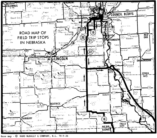
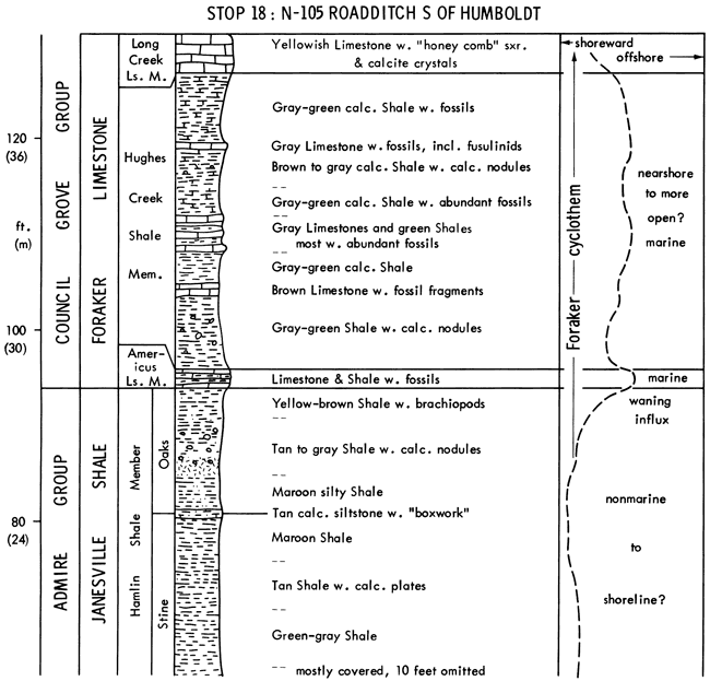
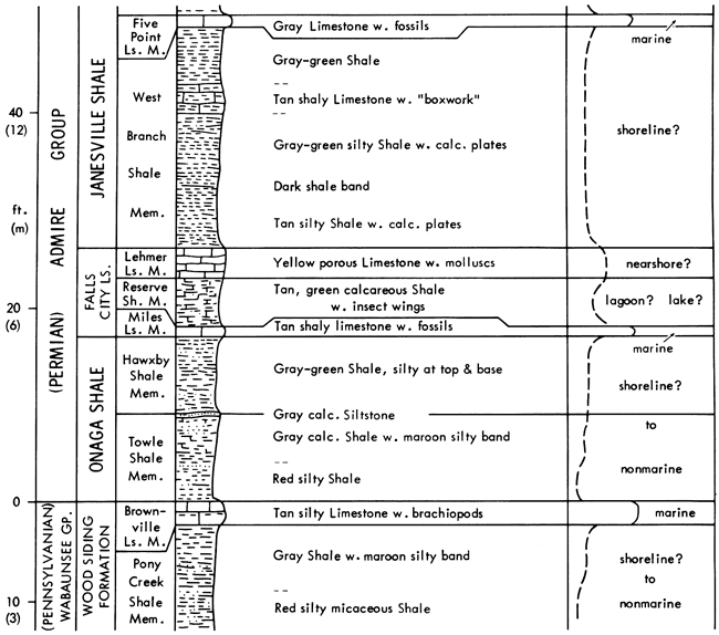
This stop shows the top of the Pennsylvanian System in the Midcontinent and several Lower Permian units, some of which afford good fossil collecting.
The Pennsylvanian-Permian boundary sequence is dominated by relatively thick, mostly unfossiliferous shales, probably deposited in nonmarine to very nearshore environments dominated by overwhelming detrital-influx. Even though some of the names are carried into Kansas, most of the thin fossiliferous limestones may represent no more than enough cessation of detrital influx to allow proliferation of shelled organisms in a shallow marine environment. A type of cyclothem, Council Grove (like the Wabaunsee type, but with red shale), was recognized by Moore (1950) in this sequence, and the one formation in the Council Grove Group here (Foraker) carries the only diversely fossiliferous shale (Hughes Creek) in this section.
Thus it represents a more important marine incursion than do the thin limestones below, but whether it records sufficient deepening to eliminate algal mud production (as seems the case in most Pennsylvanian cyclothems seen previously), or whether it involved just inhibition of algae or masking of carbonate mud by slower detrital influx in a nearshore marine environment during a longer shift in major influx is not known.
Placement of the Pennsylvanian-Permian boundary at the top of the Brownville Limestone is arbitrary because the sequence is essentially conformable with little upward change in fossils (Mudge and Yochelson, 1962). Channel sandstones (Indian Cave) originate in this horizon, and cut down into the Wabaunsee Group at places in Nebraska and Kansas. Because similar channel sandstones are known at other horizons, the erosional event at the boundary seems no more significant than those at other horizons.
Leave Stop 18 at 4:40 P.M.
Drive about 90 miles (N on N-105 through Humboldt, W on N-4, N on N-50, E on I-80 into south outskirts of Omaha) (110 min.)
Dinner at Howard Johnson's about 7:15 P.M. and overnight.
Drive about 20 miles (W on I-80, S on N-85, continuing S from jct. with N-370 for 3.5 miles, bending W 1.2 mile, then S 1.4 mile) (30 min.)
This stop shows formations seen about 340 km southward at Stops 2, 4, and 7, which still display the typical Kansas cyclothem sequence with black phosphatic core shales. Names used here are based on correlation of surface exposures from Kansas, supported by fusulinid data of Thompson (1957) for Winterset, Iowa. This is one cyclothem above the names used by the Nebraska Geological Survey (Burchett and Reed, 1967, p. S2, who recognize what we call Swope as Dennis and what we call Dennis as Sarpy, a new name for limestones in the Cherryvale Shale). Resolution of this disagreement awaits detailed biostratigraphic work.
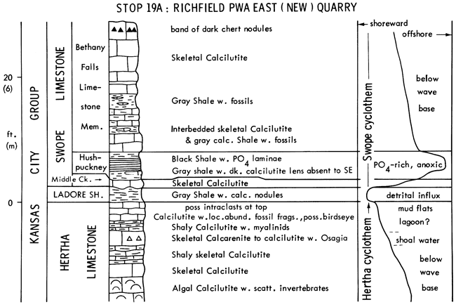
Hertha Limestone, the next cyclothem below the Swope, is not subdivided into members in Nebraska. Exposed here is the regressive limestone: Calcilutite at the base records algal mud production below effective wave base. Overlying calcarenite indicates shallowing above wave base. Shaly calcilutite above with myalinids suggests a slightly restricted lagoon. Possible birdseye and intraclasts in capping calcilutite suggest a shoreline environment, and patchy distribution of skeletal fragments may reflect storm distribution of skeletal debris on mud flats.
Ladore Shale records a rapid pulse of detrital influx.
Middle Creek Limestone and Hushpuckney Shale are the transgressive limestone and offshore shale of the Swope cyclothem.
Bethany Falls Limestone is the regressive limestone of the Swope cyclothem. The lower part here records shallowing and resumption of algal mud production below wave base, periodically diluted by slow detrital influx from distant deltas.
Leave Stop 19A at 8:40 A.M.
Walk W across road (10 min.)
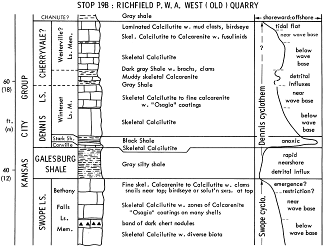
Bethany Falls Limestone is correlated between the two quarries by the band of dark chert nodules. Calcarenite zones in the upper part record shallowing above wave base. Conspicuous clams and snails, and birdseye or solution structures suggest restriction and eventual emergence at the top.
Galesburg Shale records rapid nearshore detrital influx.
Canville Limestone and Stark Shale are the transgressive limestone and offshore shale of the Dennis cyclothem.
Winterset Limestone is the regressive limestone of the Dennis, recording shallowing up to effective wave base. It is not certain whether the higher limestones with thin shales constitute the upper Winterset or represent the Westerville Limestone, a poorly defined unit where named in Iowa, but recognized as a member of the Cherryvale Shale at Kansas City. Here, these beds record fluctuation of detrital influx and eventual shallowing to tidal-flat deposition.
Leave Stop 19B at 9:20 A.M.
Drive 10 miles (N 0.7 mi, W 1.8 mi, N 0.2 mi, W 2 mi through Springfield, S on N-50 4.8 mi, then W on N-31 1.2 mi to lane on right) (20 min.)
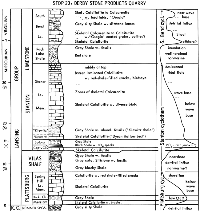
This stop shows formations already seen 340 km southward at Stops 5, 6, and 13, which display the typical Kansas cyclothem sequence here with distinct shoreline carbonate facies at the tops of the regressive limestones.
Bonner Springs Shale records a rapid detrital influx.
Merriam Limestone is the transgressive limestone of the Plattsburg cyclothem and records algal mud production during deepening.
Hickory Creek Shale is the core shale of the Plattsburg cyclothem. Although lacking a black phosphatic facies as far as known along the Midcontinent outcrop, it seems to reflect lower bottom oxygen here than in southeastern Kansas because benthic fossils are much less abundant than at Stop 6C. Apparently the Plattsburg transgression achieved water depths here sufficient to inhibit consistent vertical circulation but not to set up a strong quasi-estuarine circulation cell.
Spring Hill Limestone is the regressive limestone of the Plattsburg cyclothem recording shallowing through the optimal depths for algal mud production to a muddy shoreline facies at the top.
Vilas Shale records rapid detrital influx in environments ranging from nonmarine to nearshore as transgression began.
Captain Creek Limestone, the transgressive limestone of the Stanton cyclothem, represents a small amount of algal mud production during deepening between effective wave base and the base of the photic zone.
Eudora Shale, the core shale, records maximum transgression with water depth sufficient to establish a strong quasi-estuarine circulation cell.
Stoner Limestone is the regressive limestone of the Stanton cyclothem. The basal limestone, informally termed "Dyson Hollow bed," records enough shallowing to reestablish algal mud production. The overlying shale, informally termed "Kiewitz shale bed," records proliferation of benthic invertebrates in a stable offshore environment apparently in conjunction with inhibited algal mud production for some reason. The middle and upper Stoner record a complete shallowing-upward sequence from skeletal calcilutite deposited below wave base, through zones of skeletal calcarenite deposited above wave base, to barren laminated calcilutite with birdseye and desiccation cracks deposited on tidal flats. Although not as well developed in the older cyclothems at Stop 19, similar shoreline facies dominate the tops of most regressive limestones in Nebraska and Iowa, thus defining the northern shoreward facies belt of the Midcontinent Pennsylvanian.
Rock Lake Shale is the outside shale that terminated deposition of the Stanton cyclothem. Its thinness along outcrop, apparently resulting from erosion during a major regression of the sea (Heckel, 1975a), caused it to be included as a member of the Stanton Limestone. Here it records detrital progradation in a well-drained nonmarine environment of iron-mineral oxidation and dehydration.
South Bend Limestone, considered the "super limestone" of the Stanton megacyclothem (Moore, 1949), is still included as a member of the Stanton Limestone even though it represents the next major transgression of the sea in Kansas, where it consists only of a transgressive limestone with initial development of non-black core shale overwhelmed by detrital influx from Oklahoma (Heckel, 1978). In Nebraska, however, younger carbonates seem present in the South Bend because crinoid faunas from the upper South Bend resemble higher Virgilian faunas more than those of the basal South Bend here or the entire South Bend in Kansas, which retain strong Missourian affinities (Pabian and Strimple, 1978). Furthermore, distinct transgressive and regressive limestones are separated by a core shale in the South Bend at Stop 21. This suggests that the Missourian-Virgilian boundary, which is defined as the top of the South Bend in Kansas, falls within the South Bend in Nebraska.
Leave Stop 20 at 11:00 A.M.
Drive 2 miles (E to N-50, S across Platte River to office of Ash Grove Cement Company Plant on N outskirts of Louisville) (10 min.)
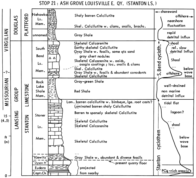
This stop shows most of the Stanton Limestone little changed from Stop 20, but affords a look at a large cement plant and a chance for lunch and leisurely fossil collecting on an extensive surface of the "Kiewitz shale bed."
Stoner Ls. and Rock Lake Sh. show the same regressive sequence as at Stop 20.
South Bend Limestone displays near the base an offshore core shale (an unstudied thin parting at Stop 20) with abundant conodonts (1000/kg). Overlying skeletal calcilutite grading up to oolitic skeletal calcarenite is the regressive limestone completing the South Bend cyclothem. The upper sandy shale carries siltstone lenses at Stop 20, but its fossil content here suggests slower detrital influx interrupting regressive carbonate deposition.
Overlying Plattford Formation records a more rapid pulse of detrital influx followed by establishment of algal mud production (Nehawka Limestone) with restricted fauna under nearshore conditions of fluctuating turbidity and salinity.
Leave Stop 21 at 2:00 P.M.
Drive 12 miles (back to N-50, S to about 0.5 mile S of jct. with S-13K; turn E on quarry road by hot mix plant) (30 min.)

This stop shows the Deer Creek Limestone seen 200 km southward at Stop 16. Here it lacks the "lower" limestone of the megacyclothem so that it more closely resembles a typical Kansas cyclothem. It also displays an abundantly fossiliferous shale ("Burroak"), which is environmentally equivalent to the "Kiewitz shale" seen at the last two stops and thus affords more good fossil collecting.
Tecumseh Shale records rapid detrital influx into a nearshore environment, which has overwhelmed Ozawkie Limestone deposition somewhere to the south and thus includes the Oskaloosa Shale seen above the Ozawkie at Stop 16.
Rock Bluff Limestone is the transgressive limestone of the Deer Creek cyclothem.
Larsh Shale is the core shale, recording maximum transgression.
Ervine Creek Limestone is the regressive limestone, which includes at its base two distinctive beds that originally were named as separate members. "Haynies limestone" records enough shallowing to reestablish algal mud production. Overlying "Burroak shale bed" records proliferation of benthic invertebrates and inhibition of algal mud production in a stable offshore environment. R.K. Pabian discusses generic replacement in crinoid assemblages in this environment from the Missourian Kiewitz to the Virgilian Burroak shales in a later article in this guidebook. The overlying limestone facies record shallowing up through wave base to probable muddy shoreline environments at the top.
Calhoun Shale records rapid detrital influx that terminated the cyclothem.
Leave Stop 22 at 3:30 P.M.
Drive about 125 miles (back to N-50, S 14 miles to N-2, E through Nebraska City and across Missouri River to 1-29., S to St. Joseph for Dinner around 6:30 P.M.); then S on I-29 about 35 miles to Holiday Inn at Kansas City International Airport, arriving about 8:15 P.M. for overnight stay.
Berendsen, P., and Nodine-Zeller, D.E., 1978, Radiolarian-sponge-bearing phosphate nodules from Pennsylvanian black shales, southeastern Kansas (abstract): Geol. Soc. America, Abstracts w. Prog., v. 10, p. 1-2.
Burchett, R.R., and Reed, E.C., 1967, Centennial guidebook to the geology of southeastern Nebraska: Univ. Nebraska, Conservation and Survey Div., Nebraska Geol. Survey, Lincoln, 83 p.
Ebanks, W.J., Jr., James, G.W., and Livingston, N.D., 1977, Evaluation of heavy-oil and tar sands in Bourbon., Crawford, and Cherokee counties, Kansas-Final Report: U.S. Dept. Energy, BERC/RI-77/20, 110 p.
Elias, M.K., 1937, Depth of deposition of the Big Blue (late Paleozoic) sediments in Kansas: Geol. Soc. America, Bull., v. 48, p. 403-432.
Evans, J.K., 1967, Depositional environment of a Pennsylvanian black shale (Heebner) in Kansas and adjacent states: Ph.D. dissert., Rice Univ., 162 p.
Ferm, J.C., 1970, Allegheny deltaic deposits: SEPM Spec. Publ. 15, p. 246-2S5.
Frost, J.G., 1975, Winterset algal-bank complex, Pennsylvanian, eastern Kansas: American Assoc. of Petroleum Geologists, Bull., v. 59, p. 265-291.
Hakes, W.G., 1976, Trace fossils and depositional environment of four clastic units, Upper Pennsylvanian megacyclothems, northeast Kansas: Univ. Kansas Paleont. Contr., Art. 63, 46 p. [available online]
Hakes, W.G., 1977, Trace fossils in Late Pennsylvanian cyclothems, Kansas; in, Trace fossils 2, T.P. Crimes and J.C. Harper, ed.: Geol. Journal, Spec. Issue, no. 9, p. 209-226.
Harbaugh, J.W., 19S9. Marine bank development in Plattsburg Limestone (Pennsylvanian), Neodesha-Fredonia area, Kansas: Kansas Geol. Survey, Bull. 134, pt. 8, p. 289-331. [available online]
Harbaugh, J.W., 1962, Geologic guide to Pennsylvanian marine banks, southeast Kansas: Kansas Geol. Society, 27th Field Conf. Guidebook, p. 13-67.
Harbaugh, J.W., and others, 1965, Field conference guide to Pennsylvanian marine banks, southeastern Kansas: Geol. Soc. America Ann. Mtg., Kansas City, Field Conf. Guidebook, Kansas Geol. Survey, Lawrence, Kansas, p. 1-46.
Heckel, P.H., 1972, Recognition of ancient shallow marine environments: SEPM Spec. Publ. 16, p. 226-286.
Heckel, P.H., 1975, Field guide to Stanton Formation (Upper Pennsylvanian) in southeastern Kansas: Kansas Geol. Society, 31st Field Conf. Guidebook., p. 2-71.
Heckel, P.H., 1975a, Stratigraphy and depositional framework of the Stanton Formation in southeastern Kansas: Kansas Geol. Survey, Bull. 210, 45 p. [available online]
Heckel, P.H., 1977, Origin of phosphatic black shale facies in Pennsylvanian cyclothems of Mid-Continent North America: American Assoc. of Petroleum Geologists, Bull., v. 61, p. 1045-1068.
Heckel, P.H., 1978, Field guide to Upper Pennsylvanian cyclothemic limestone facies in eastern Kansas: Kansas Geol. Survey, Guidebook Ser. 2. p. 1-69, 76-79. [available online]
Heckel, P.H. and Baesemann, J.F., 197S. Environmental interpretation of conodont distribution in Upper Pennsylvanian (Missourian) megacyclothems in eastern Kansas: American Assoc. of Petroleum Geologists, Bull., v. S9, p. 486-509.
Heckel, P.H. and Cocke, J.M., 1969, Phylloid algal-mound complexes in outcropping Upper Pennsylvanian rocks of Mid-Continent: American Assoc. of Petroleum Geologists, Bull., v. 53, p. 1058-1074.
Heckel, P.H., and Swade, J.W., 1977, Two types of Midcontinent Pennsylvanian black shales and their respective conodont faunas (abstract): Geol. Soc. America, Abstracts w. Prog., v. 9, p. 604.
Moore, R.C., 1936, Stratigraphic classification of the Pennsylvanian rocks of Kansas: Kansas Geol. Survey, Bull. 22, 2S6 p.
Moore, R.C., 1949, Divisions of the Pennsylvanian System in Kansas: Kansas Geol. Survey Bull. 83, 203 p. [available online]
Moore, R.C., 1950, Late Paleozoic cyclic sedimentation in central United States: 18th Internat. Geol. Cong., 1948, Gt. Britain, Rept., pt. 4, p. 5-16.
Moore, R.C., and Merriam, D.F., 1959, Kansas Field Conference. . .1959: Assoc. American State Geologists Ann. Mtg., Kansas Geol. Survey, Lawrence, Kansas, 55 p.
Moore, R.C., and Merriam, D.F., 1965, Upper Pennsylvanian cyclothems in the Kansas River Valley: Geol. Soc. America Ann. Mtg., Kansas City, Field Conf. Guidebook, Kansas Geol. Survey, Lawrence, Kansas, 22 p.
Mossler, J.H., 1973, Carbonate facies of the Swope Limestone formation (Upper Pennsylvanian), southeast Kansas: Kansas Geol. Survey Bull. 206, pt. 1, p. 1-17. [available online]
Mudge, M.R., and Yochelson, E.L., 1962, Stratigraphy and paleontology of the uppermost Pennsylvanian and lowermost Permian rocks in Kansas: U.S. Geol. Survey, Prof. Paper 323, 213 p.
Nelson, D.L., 1978, Petrology and paragenesis of the Spring Hill algal mound (Plattsburg Formation, Upper Pennsylvanian) at Neodesha, Kansas: M.S. thesis, Univ. Iowa.
Owen, D.E., 1959, Stratigraphy of bioherms and other deposits of the Upper Pennsylvanian Bern Limestone in east-central Kansas: M.S. thesis, Univ. Kansas, 185 p.
Pabian, R.K., and Strimple, H.L., 1978, Suggested reevaluation of the South Bend Limestone (Late Pennsylvanian-Missourian) of southeastern Nebraska and southeastern Kansas based upon crinoids (abstract): Proc. Nebraska Acad. Science 88th Ann. Mtg., p. 45.
Ravn, R.L., and Heckel, P.H., 1978, Algal sparite facies in Captain Creek Limestone: Kansas Geol. Survey, Guidebook Ser. 2, p. 70-75. [available online]
Ravn, R.L., and others, 1978, Early submarine cement as potential void-supporting framework in Pennsylvanian algal mounds of Kansas (abstract): Geol. Soc. America. Abstracts w. Prog., v. 10, p. 476.
Reed, E.C., and Burchett, R.R., 1966, Stratigraphic sequences in the Pennsylvanian of Nebraska and their relationships to cyclic sedimentation: Kansas Geol. Survey. Bull. 169, v. 2, p. 441-447. [available online]
Schenk, P.E., 1967, Facies and phases of the Altamont Limestone and megacyclothem (Pennsylvanian), Iowa to Oklahoma: Geol. Soc. America, Bull., v. 78, p. 1369-1384.
Senich, M.A., 1975, Relation of biotic assemblages to lithofacies in Stanton Limestone (Upper Pennsylvanian), southeastern Kansas: M.S. thesis, Univ. Iowa, 198 p.
Senich, M.A., 1978, Macrofossil distribution in the Stanton Formation (Upper Pennsylvanian) in eastern Kansas: Ph.D. dissert., Univ. Iowa, 301 p.
Stobbe, W.J., 1971, Petrology and stratigraphy of the Dodds Creek Member,Galesburg Formation (Upper Pennsylvanian) of southeastern Kansas: M.S. thesis, Wichita State Univ., 87 p.
Thompson, M.L., 1957, Northern Midcontinent Missourian fusulinids: Jour. Paleontology, v. 31, p. 289-328.
Toomey, D.F., 1969, The biota of the Pennsylvanian (Virgilian) Leavenworth Limestone, Midcontinent region, pt. 1, Stratigraphy, paleogeography, and sediment facies relationships: Jour. Paleontology, v. 43, p. 1001-1018.
Troell, A.R., 1965, Sedimentary facies of the Toronto Limestone, lower limestone member of the Oread megacyclothem (Virgilian) of Kansas: Ph.D. dissert., Rice Univ., 184 p.
Troell, A.R., 1969, Depositional facies of Toronto Limestone Member (Oread Limestone, Pennsylvanian), subsurface marker unit in Kansas: Kansas Geol. Survey, Bull. 197, 29 p. [available online]
Wanless, H.R., and others, 1970, Late Paleozoic deltas in the central and eastern United States: SEPM Spec. Publ. 15, p. 21S-245.
Weller, J.M., 1958, Cyclothems and larger sedimentary cycles of the Pennsylvanian: Jour. Geology, v. 66, p. 195-207.
Wood, R.H., Jr., 1977, Conodont distribution in facies of the Stanton Formation (Upper Pennsylvanian, Missourian) in southeastern Kansas: M.S. thesis, Univ. Iowa, 121 p.
Wood, R.H., Jr., and Heckel, P.H., 1977, Significance of conodont distribution in the Stanton cyclothem (Missourian, Upper Pennsylvanian) in eastern Kansas (abstract): Geol. Soc. America, Abstracts w. Prog., v. 9, p. 667-668.
Zeller, D.E., ed., 1968, The stratigraphic succession in Kansas: Kansas Geol. Survey, Bull. 189, 81 p.
Next Page--Coal, Heavy-oil, Crinoids
Kansas Geological Survey, Pennsylvanian Cyclic Platform Deposits of Kansas and Nebraska
Placed on web Nov. 6, 2010; originally published in 1978.
Comments to webadmin@kgs.ku.edu
The URL for this page is http://www.kgs.ku.edu/Publications/Bulletins/GB4/index.html