Kansas Geological Survey, Guidebook 2, originally published in 1978
with assistance from
John C. Mitchell
David L. Nelson
Robert L. Ravn
Originally published in 1978 as Kansas Geological Survey Guidebook 2. This is, in general, the original text as published. The information has not been updated.
Created for Society of Economic Paleontologists & Mineralogists 52nd Annual Meeting and The American Association of Petroleum Geologists 63rd Annual Meeting, SEPM Field Trip #2.
First Day, Saturday, 8 April 1978 |
||
| Start loading bus at Holiday Inn near KCI Airport, NW of Kansas City, Mo. at 6:45 A.M. | # minutes/time | |
|---|---|---|
| Leave Motel at 7:00 A.M. | ||
| Drive 15 miles (S on 1-29, 1-635, out exit SA State Ave East; rt on 38th St, rt on K32, under all overpasses) | 20/7:20 | |
| Stop 1: K32 roadcut: Iola Limestone, open marine cyclothem; parts of 2 lower cyclothems. | 35/7:55 | |
| Drive 55 miles (S on 1-635 and U.S. 69) | 70/9:05 | |
| Stop 2: U.S. 69 roadcuts N of K135 Jct: Two more open marine cyclothems | (80/10:25) | |
| 2A: Swope Limestone: phosphatic black shale, distinct regressive facies | 40/9:45 | |
| Drive or walk 0.3 mile (S on U.S. 69) | 10/19:55 | |
| 2B: Hertha Limestone: nonblack core shale, distinct regressive facies | 30/10:25 | |
| Drive 51 miles (S on U.S. 69, W on K52, S on U.S. 59) | 65/11:30 | |
| Stop 3: U.S. 59 roadcut at Katy Lake: Iola Limestone in algal mound facies belt | 30/12:00 | |
| Drive 43 miles (S on U.S. 59, W on U.S. 54, S on U.S. 169, W on K39). LUNCH ON BUS | 60/1:00 | |
| Stop 4: Wilson County State Lake: Stanton Limestone in algal mound facies belt | (120/3:00) | |
| Unload bus in lane W of spillway bridge; walk down spillway | 15/1:15 | |
| 4A: Plunge pool: Basal Stanton transgressive oolite & stromatolite | 45/2:00 | |
| Walk about 0.5 mile (E below highway) | 20/2:20 | |
| 4B: Quarry: Middle Stanton offshore facies | 30/2:50 | |
| Walk back to bus parked in Picnic grounds | 10/3:00 | |
| Drive 4 miles (N on U.S. 75, past Buffalo turnoffs to downgrade) | 5/3:05 | |
| Stop 5: U.S. 75 roadcut at Buffalo: Stanton regressive mound-edge calcarenite | 25/3:30 | |
| Drive 21 miles (N to 1st left, then S, then E in Buffalo back to U.S. 75 & S to Altoona; W on K47 across river, 1st N, 1st W & S on gravel rds.) | 30/4:00 | |
| Stop 6: Altoona roadcuts: Stanton channel facies | (105/5:45) | |
| 6A: North Altoona cut: channel-margin facies change | 25/4:25 | |
| Drive 1 mile (S to K47, then E) | 5/4:30 | |
| 6B: Main Altoona cut on K47: channel-axis facies | 75/5:45 | |
| Drive 10 miles (E on K47, S on U.S. 75) to Old Homestead Motel, U.S. 75 N, Neodesha, Ks. | 15/6:00 | |
| Dinner at Old Homestead Motel about 7:00 P.M.; STAY OVERNIGHT | ||
Second Day, Sunday, 9 April 1978 |
||
| Start loading bus at Old Homestead Motel at 7:45 A.M. | ||
| Leave Old Homestead Motel at 8:00 A.M. | ||
| Drive 6 miles (S on U.S. 75 through Neodesha, W on K96 | 10/8:10 | |
| Stop 7: K96 roadcut: Plattsburg algal mound facies | 70/9:20 | |
| Drive 14 miles (W on K96 about 1.4 mile, S on gravel 4 paved roads, W on paved road to Dam entrance, S & W past Dam headquarters. | 25/9:45 | |
| Stop 8: Elk City Dam roadcut: Stanton algal mound facies with sparite | 75/11:00 | |
| Drive 24 miles (W to Elk City, S 4 E on U.S. 160, noting facies changes in roadcuts from bus along way) | 30/11:30 | |
| Stop 9: U.S. 160 roadcut: Drum Limestone oomoldic oolite | 30/12:00 | |
| Drive 21 miles (W on U.S. 160, S on 75 4 paved county roads; LUNCH ON BUS) | 30/12:30 | |
| Stop 10: Tyro Quarry: Tyro oolite (Stanton Fm) partly dolomitized oolite | 40/1:10 | |
| Drive 180 miles (S to Tyro, W on U.S. 166, S on U.S. 75 to Bartlesville and Tulsa, thence to Oklahoma City) | 200/4:30 | |
| Arrive in Oklahoma City about 4:30 P.M. END OF TRIP | ||
Leader: P.H. Heckel, Department of Geology, University of Iowa
Assistant Leaders: J.C. Mitchell, D.L. Nelson, and R.L. Ravn, Department of Geology, University of Iowa.
Logistics and Arrangements: Helen Wolfe, Kansas Geological Survey, Lawrence, Kansas.
I am indebted to many persons whose generosity and aid helped make this field trip and guidebook possible. Graduate students John Mitchell, Bob Ravn, and Dave Nelson of Iowa University aided in field work and provided important information from their projects on the Iola, Hertha, and Plattsburg Formations, respectively. Helen Wolfe of the Kansas Geological Survey arranged for field trip meals, lodging, transportation and guidebook publication through the Kansas Geological Survey. The following Kansas landowners allowed access to their property for certain field trip stops: Leon Englemann (Stop 4B), and Bob Wilson (Stop 10). John Mitchell drafted figures 1-3 and Table 1 and, along with Bob Ravn, prepared the photographs of thin sections. Rick Stull typed the guidebook. The American Association of Petroleum Geologists permitted use of published figures from Heckel (1977) in this guidebook.
Much of the text of this guidebook is essentially a preliminary skeleton draft of papers on development of concepts of Midcontinent Pennsylvanian cyclothems and on Stanton stratigraphy in the algal mound facies belt, to be elaborated for eventual publication elsewhere.
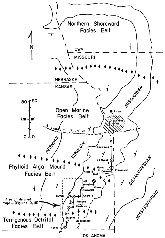
This field trip will visit a number of exposures of Upper Pennsylvanian (Missourian) limestones in eastern Kansas, in order to examine the relationship of carbonate facies with both the vertical cyclic sequence and the lateral change along outcrop, from Kansas City southward into the region of phylloid algal buildups in southeastern Kansas (Fig. 1).
Figure 1-- Pennsylvanian outcrop in eastern Kansas and adjacent region, showing stage boundaries with solid lines and Missourian facies belts separated by diamond symbols. Field trip route shown by arrows, with location of stops by circled numbers.
Previous field trips to this region led by Harbaugh (1962; et al., 1965) focused on stratigraphy, petrography and recognition of algae in these buildups ("marine banks") in the two limestone formations of the Lansing Group (Fig. 2) in southeastern Kansas. Although his presentation of the petrography predated recent advances in understanding void-filling cements, he recognized the importance of void-filling in many rocks that would have appeared "recrystallized" to many petrologists of that time. Nevertheless, even with renewed petrologic study on several of the units, many of the complex rocks still defy straightforward diagenetic interpretation.
The field trip led by Heckel (1975) focused on vertical and lateral facies changes related to depositional phase and original topography in one formation (Stanton) in southeastern Kansas. Part of the guidebook for that trip served as a framework for a later paper (Heckel, 1977) presenting a depositional model that explains the vertical cyclic lithologic sequence of most of the Kansas Pennsylvanian in terms of realistic processes of deposition.
In addition to revisiting several localities from the earlier field trips, the present trip will encompass a greater geographic area and stratigraphic interval than earlier trips, in order to illustrate application of the depositional model to several formations over a larger area.
Bedrock geology of eastern Kansas is characterized by an alternation of laterally persistent Middle and Upper Pennsylvanian sandy shales from 3 to 30 m thick and containing local sandstones, with laterally persistent limestones from 3 to 15 m thick and containing thin shale beds. These rocks strike generally north-northeast to south-southwest (Fig. 1) and dip gently westward about 30 feet per mile (approximately 5.5 m/km). South of the limit of thin glacial cover, the more resistant thicker limestone and sandstone units are cut by rivers and streams to form low, irregular, eastward-facing escarpments, prongs, and flat-topped hills that break the otherwise nearly flat plain and allow lateral tracing of major units with ease.
Figure 2--Columnar section of exposed Pennsylvanian rocks in eastern Kansas, with formations to be visited indicated by Stop numbers. Member names are omitted, but nature of members is shown by discrete lithic symbols within formations. Lithic symbols are standard, with coals as black lenses and black shales as long horizontal dashes. Vertical scale approximate, with limestones, black shales and coals expanded at expense of gray shales and sandstones. (Adapted from Zeller, 1968, Plate 1).
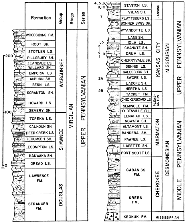
The Pennsylvanian System in eastern Kansas comprises 49 formations that are subdivided into 129 formally named members and aggregated into 8 groups and 3 stages of the Middle and Upper Pennsylvanian Series (Fig. 2). Although this number of formations and members might seem excessive in only about 700 to 800 m of section, most were established by R.C. Moore and his co-workers while mapping Kansas and surrounding states in the 1930's and 1940's, because of the remarkable lateral persistence of many distinctive thin rock units, some less than 1 m in thickness. Much of the fine subdivision of the stratigraphic hierarchy was fashioned by Moore (1936, 1949) to accommodate the equally remarkable vertical repetition of certain distinctive limestone and shale units throughout most of the sequence.
The coarser subdivisions of the Kansas Pennsylvanian reflect dominance of certain rock types within the repetitive sequence. At the base of the sequence, the Middle Pennsylvanian (Desmoinesian) Cherokee Group consists mainly of shale, with coal seams, local sandstone bodies, and thin limestone beds. Above the Cherokee, the Marmaton Group forms the top of the Middle Pennsylvanian and is the lowest part of the Kansas sequence that consists of an alternation of sandy shale and limestone formations. Above the Marmaton, the lower part of the Upper Pennsylvanian Series constitutes the Missourian Stage in its type area, which is the focus of this field trip (Fig. 2). At the base of the Missourian, the Pleasanton Group consists largely of shale, with a basal sandstone. Most of the Missourian comprises the Kansas City and Lansing Groups, which consist of a thick sequence of alternating sandy shale and limestone formations. The upper part of the Upper Pennsylvanian constitutes the Virgilian Stage in its type area. At its base, the Douglas Group consists largely of shale with thick local sandstones and thin limestones. In the middle, the Shawnee group is an alternation of sandy shales and thick prominent limestones containing several thin shale members. At the top, the Wabaunsee Group is an alternation of thicker more prominent sandy shales, often containing coal seams, and thinner less prominent limestones. The Virgilian is overlain by Lower Permian rocks that continue the basic alternation of shale and limestone formations.
Cyclothems have long been identified in the repetitive Middle-Upper Pennsylvanian sequence of eastern Kansas (Moore, 1936, 1949, 1950; Weller, 1958). Moore recognized the basically transgressive-regressive nature of sedimentation responsible for simple cyclothems in the Cherokee and Wabaunsee Groups (Fig. 3A,B), in which largely nonmarine sandy shales with coals alternate with marine shales and limestones. This allowed relatively straightforward depositional interpretation, and the fusulinid-bearing limestone was regarded as the farthest offshore deposit, based upon the paleoecological work of Elias, which was published in 1937.
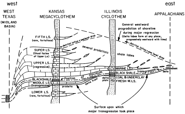
Figure 3--Types of cyclothems recognized by Moore (1936, 1949, 1950) in Kansas Pennsylvanian. A, Cherokee cyclothem; coal and black shale are most laterally persistent members; marine deposits are indicated by marine fossils, which are mostly pelagic in black shale. B, Wabaunsee cyclothem with members numbered by Moore (1936, p. 25); coals and limestones are laterally persistent, but black shale is absent; marine portion shows symmetrical trend of nearshore-offshore-nearshore fossil assemblages (Moore, 1950). C, Shawnee megacyclothem, in which each shale-limestone member couplet was considered a modified simple cyclothem (A-E), implying that "black shale" member is genetically similar to other shales (sea-level curve 1); similar megacyclothems recognized in Marmaton and Missourian sequence lack "lower," "fifth," and most "super" limestone members; later workers recognized black shale member as genetically distinct from other shale members (sea-level curve 2); (from Heckel and Baesemann, 1975, Fig. 1).
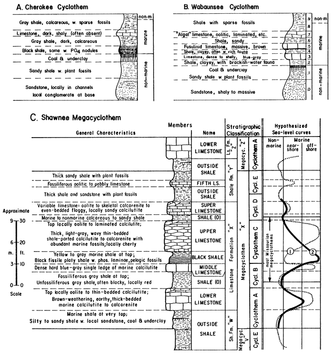
In order to explain the more complex repetitive sequences involving several fusulinid-bearing limestone members in the Shawnee Group, Moore (1936) developed the concept of megacyclothem (Fig. 3C). These involve a hierarchical classification of modified simple cyclothems (A through E), which appear essentially as shale-limestone couplets, grouped to form a cycle of cyclothems. Megacyclothems thus are complex but distinctive successions of different shale-limestone couplets that are repeated several times upward in the sequence. Moore (1936, 1950) applied the Shawnee megacyclothem classification to the cycles developed in the Marmaton, Kansas City and Lansing Groups below, but recognized that the lowest and highest cyclothems (A, E--corresponding to the "lower" and "fifth" limestone members) are only doubtfully distinguished or definitely lacking. Megacyclothems in all these groups are nucleated around the limestone formations containing the thin shale members, and their boundaries lie within the intervening sandy shale formations (Fig. 3C).
Regarding each shale-limestone couplet in a megacyclothem as an individual simple cyclothem, no matter how modified, had the unfortunate effect of implying that the thin shale carrying the black phosphatic shale facies ("black shale member") is genetically similar to the other shales in the megacyclothem. The resulting interpretation (Fig. 3C, sea-level curve 1) involved rapid nearshore (shale)–offshore (limestone) sea-level oscillations through each megacyclothem that did not explain why the black shale is so different from the other shales or why several of the limestones are so different from one another. Although Moore (1950, p. 15) interpreted the black shale as deposited in a kind of marine swamp in which thick growth of seaweed prevented bottom disturbance, he nevertheless (ibid.) regarded it as the least well understood member of the megacyclothem, partly because of its greater lateral persistence than almost any of the limestones, which were considered the most offshore deposits. It is ironic that he remarked also (ibid., p. 13) that as megacyclothems are traced southward along outcrop, all limestone members become more separated as the shale members thicken toward the Oklahoma detrital source, except for the two limestones separated by the black shale. This was an important clue that the black shale is genetically unlike the other shales, and, in fact, resulted not from increased detrital influx but rather from more offshore sediment-starved conditions (Fig. 3C, sea-level curve 2) established in deeper water at times when detrital influx was trapped near shorelines far from eastern Kansas (Heckel,1972; Heckel and Baesemann, 1975; Heckel, 1977).
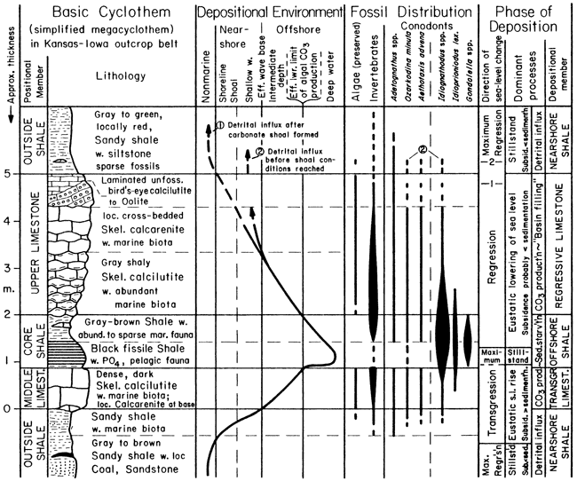
It turns out that only the middle portion of the megacyclothem, specifically the "middle" and "upper" limestone members and intervening thin shale member that typically contains the phosphatic black facies, occurs commonly enough throughout the Marmaton through Shawnee groups to have basic depositional significance. Each depositional cycle presently recognized by Heckel (1977) in these groups records a single transgressive-regressive marine sequence (Fig. 4), and consists in ascending order, of 1) thick, nearshore sandy ("outside") shale (top of underlying shale formation), 2) thin, transgressive ("middle") limestone, 3) thin, offshore ("core") shale (often with phosphatic black facies), 4) thick, regressive ("upper") limestone, and 5) thick, nearshore sandy shale again (base of overlying shale formation). This explains the difference between the black (=core) shale member and the other shales, and between at least two of the limestone members. A third limestone member, the "super," which is present in several cycles, is essentially a shoal water facies (oolite, etc.) of the upper limestone separated by a fortuitous shale bed.
Figure 4--Basic vertical sequence of individual "Kansas cyclothem," the transgressive-regressive depositional unit characterizing, with only minor modification, most of the Marmaton, Kansas City, Lansing and Shawnee Groups of the Midcontinent Pennsylvanian. Positional terms derive from Moore (1936) for limestones and Heckel and Baesemann (1975) for shales. Conodont faunas conspicuously differentiate the two shale members. (From Heckel, 1977, Fig. 2).
Each of these transgressive-regressive depositional units with an offshore shale between two limestones is termed a "Kansas cyclothem." The older usage of "cyclothem" in the Marmaton through Shawnee Groups for essentially a shale-limestone-member couplet within the megacyclothem is abandoned, and the term megacyclothem is applied only to the concept of more complex sequences.
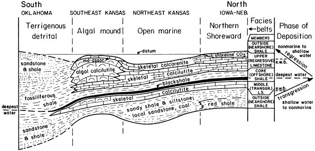
Facies and depositional environments are considered for the Marmaton through Shawnee Groups within the framework of the basic Kansas cyclothem (Heckel, 1977), with comments on major facies changes (Fig. 5) observed along the Midcontinent outcrop belt extending southward into Oklahoma and northward into Missouri, Iowa, and Nebraska.
Fig. 5--Basic pattern of facies change within Kansas cyclothem across facies belts along Midcontinent Pennsylvanian outcrop (Fig. 1). Datum is interpreted sea level when increased detrital influx ended deposition of regressive limestone. (From Heckel, 1977, Fig. 4).
Nearshore shales comprise the shale formations that alternate with limestone formations in the cyclic sequence, but include some shale members (marked 0 on Fig. 3C) within those limestone formations that contain more than one shale member. The dominance of shale formations that lie "outside" the "bundle" of limestones and thin shales that constitute the limestone formations led these shale portions (or "members") of the cyclothem to be termed "outside shales" in a positional sense before their depositional significance was thoroughly established.
Nearshore shales are typically sandy; though variable in thickness, they are generally thick, often attaining 15 m and locally 40 m in thickness. Commonly they contain thin layers of siltstone and sandstone carrying macerated plant fragments and only a sparse marine fauna of low diversity. They locally contain deposits that are demonstrably nonmarine, such as coals and underclays, shales with well preserved land plant fossils, and channel sandstones, all lacking marine fossils. They are the units within which Wanless and his coworkers (e.g., 1970) have mapped many deltaic sequences.
A deltaic depositional model of abundant detritus prograding into the shallow sea readily accounts for the characteristics of these shales. Each delta lobe eventually became abandoned as new distributaries formed a shorter route to the sea and started prograding younger lobes in different places (e.g., Ferm, 1970). Variability in thickness of the nearshore shales reflects the local nature of each delta lobe. The nonmarine deposits record the subaerial deltaic plain. The rocks with sparse marine fossils of low diversity record prodelta to delta-front environments where rapid deposition, increased turbidity, and fluctuating salinity reduced the abundance and diversity of marine organisms.
Southward, nearshore shales tend to thin over thickened portions of underlying limestones; then most thicken substantially in the Kansas-Oklahoma border region where they constitute proportionally greater amounts of the sequence (Fig. 5) as they approach a major deltaic detrital source in Oklahoma.
Most nearshore shales tend to thin northward into Iowa and Nebraska away from the major directions of detrital influx. Parts of some become more abundantly and diversely fossiliferous, reflecting less detrital influx with its attendant unstable conditions. Parts of some become red in color, which indicates enough subaerial exposure for complete oxidation and dehydration of iron minerals.
Transgressive limestones are the thin (0.3 to 1.5 m), dense, dark skeletal calcilutites denoted as the "middle" limestone of Moore's megacyclothem. They carry a diverse and relatively abundant marine biota comprising all the major phyla, including algae, although fossils do not seem abundant on outcrop because of the denseness of the rock. Fine grain size and diverse biota indicate deposition in the open marine environment far enough offshore to be below effective wave base, but above effective base of the photic zone. If shoal-water facies such as oolite, stromatolite and sandstone are present with the skeletal calcilutite, they are only at the base, as seen in the Stanton Formation at Stops 4A, 8, and 10 on this field trip.
Aside from a few that thicken with increase in phylloid algae content in southeastern Kansas (e.g., Stanton, Stops 4, 8), transgressive limestones undergo little lateral facies change either northward or southward, yet several extend laterally for hundreds of miles along outcrop. Thus transgressive limestones generally record widespread marine inundation of the Midcontinent, with carbonate sediment production mainly at depths below effective wave base where minor variations in topography on the underlying delta lobes had little influence over facies. One transgressive limestone of more limited lateral extent is largely skeletal calcarenite with abraded grains (Hertha, Stop 2B), thus probably developed earlier during transgression.
Offshore shales are the thin (0.3 to 2.0 m), laterally persistent, nearly non-sandy, gray marine shales that lie between the "middle" and "upper" limestone members within limestone formations and were termed "core shales" by Heckel and Baesemann (1975) because of their central position within the megacyclothem. They typically contain a black fissile facies rich in organic matter, which generally carries nodules and laminae of nonskeletal phosphorite (Iola, Stop 1; Swope, Stop 2A) and relatively high concentrations of certain heavy metals. The black facies lacks definitely benthic fossils, carrying mainly conodonts in great abundance, fish remains, orbiculoid brachiopods and a few other fossils reasonably inferred to have been pelagic or epipelagic. The gray facies typically carries only a sparse macrofauna of several benthic invertebrate groups, including echinoderms and articulate brachiopods (Hertha, Stop 2B), often in addition to those found in the black facies. Only away from the black facies do the offshore shales carry abundant and diverse macrofossils. Like transgressive limestones, offshore shales also change laterally very little along the entire length of the outcrop.. Those that lose the black facies laterally, generally retain phosphate nodules in the sparsely fossiliferous gray facies (Iola, Stop 3; Stanton, Stops 4B, 10).
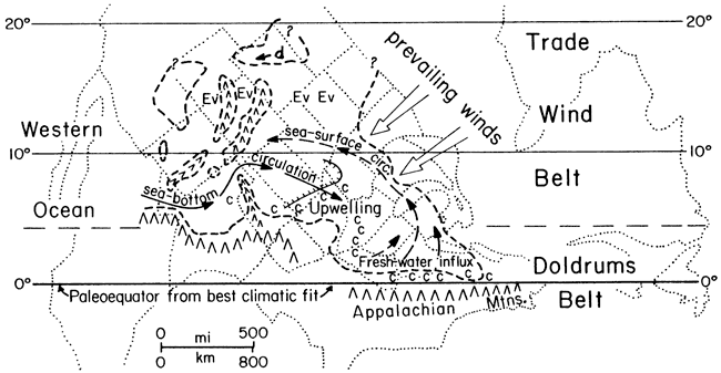
Thinness in conjunction with great lateral persistence, fineness of detrital grain size, presence of marine fauna, great abundance of conodonts and conspicuous nonskeletal phosphorite, all point to very slow sedimentation away from detrital influx, far offshore in deeper water. Presence of abundant organic matter along with lack of benthic fossils indicates anoxic bottom conditions. Lack of bottom oxygen in conjunction with very high concentrations of phosphate and heavy metals is explained as the result of a two-layered quasi-estuarine circulation cell in the Midcontinent sea (Fig. 6), established when water became deep enough to form a thermocline above the bottom and prevent replenishment of bottom oxygen by vertical circulation. Surface water blown out of the sea by prevailing Pennsylvanian trade winds (Fig. 7) was replaced by upwelling of deeper phosphate-rich water of the oxygen-minimum zone, drawn in below the thermocline from intermediate depths of the open ocean. Nutrients brought into the photic zone by this upwelling promoted immense blooms of plankton, which settled back into the incoming lower water layer. There its decay depleted the bottom water of already low oxygen, continually enriched it in phosphate (as well as heavy metals that organisms concentrate), and ultimately caused deposition of unoxidized organic matter and conspicuous phosphorite on the sea bottom, along with little other sediment, to produce the phosphatic black facies.
Figure 6--Expected patterns of vertical circulation in west--facing tropical epicontinental sea: A, Low sea-level stand when vertical circulation and algal photosynthesis maintain bottom oxygen; B, High sea-level stand when thermocline allows prevailing trade winds to establish large quasi-estuarine circulation cell, which results in depletion of bottom oxygen and concentration of phosphate. (From Heckel, 1977, Fig. 5).
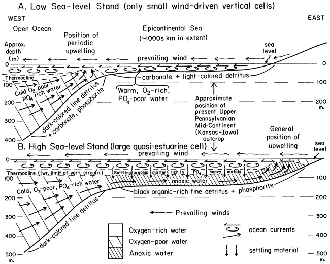
Figure 7--Pennsylvanian paleogeography of North America based on distribution of major coals (c) in ancient doldrums belt, evaporites (Ev) and dune sands (d) in ancient trade-wind belt, and paleomagnetic data. Dashed lines mark maximum transgression when quasi-estuarine cell was operating. (From Heckel, 1977, Fig. 6).
Similar circulation that enriched phosphate but did not deplete all bottom oxygen accounts for the sparsely fossiliferous gray facies with phosphorite nodules. Merely far offshore deposition, probably below the effective limit of algal production of carbonate mud, but without persistent establishment of the oxygen-depleting quasi-estuarine circulation cell, accounts for the more abundantly and diversely fossiliferous gray facies of the offshore shale.
Regressive limestones comprise the "upper," sometimes with the "super," limestone members of Moore's megacyclothem. They are generally thicker (up to 9 m) than transgressive limestones and contain a greater variety of facies.
The lower parts of regressive limestones consist largely of wavy-bedded, shale-parted skeletal calcilutite with an abundant and diverse marine biota consisting of all major phyla (all cyclothems at most stops). Lateral persistence of this facies along outcrop in conjunction with fine-grained lithology and diverse biota indicates that this part of regressive limestones, like most of the transgressive limestones, was deposited offshore- below effective wave base but above the lower limit of algal carbonate production.
In places a peculiar type of skeletal calcarenite is present at the base of the regressive limestone (Iola, Stop 1; Stanton, Stop 4B). These calcarenites consist entirely of invertebrate grains that display no evidence of grain abrasion, cross bedding or definite algal structures, and thus formed in quiet water below effective wave base, and probably below the limit of much algal activity as well.
The upper parts of regressive limestone members display the most conspicuous lateral segregation of facies along the Midcontinent outcrop belt (Fig. 5), as would be expected in shallow water where minor differences in bottom topography produce conspicuous lateral changes in facies.
In northeastern Kansas most regressive limestones grade upward to skeletal calcarenite that contains various proportions of abraded algal as well as invertebrate grains, osagia-coated grains, and grains with "micrite envelopes" resulting from algal boring; cross bedding is apparent in places. Although this vertical succession records increasing water agitation and light penetration with time as water shallowed above effective wave base, this facies still records a relatively open marine environment, which defines this portion of the outcrop belt as the "open marine facies belt" (Fig. 1, 5), where such conditions persisted longest during deposition of the regressive limestone. In some places, some regressive limestones show no conspicuous evidence of shallowing upward in this region (Iola, Stop 1). In other places, some regressive limestones display even more conspicuously shoal-water facies at the top, such as oolite (Swope and Hertha, Stop 2; Drum, Stop 9), and sparsely fossiliferous laminated calcilutites that probably record local lagoons (Hertha, Stop 2B). Caliche soil formation has been identified at the top of one unit (Swope, Stop 2A).
Northward, nearly all regressive limestones grade upward into unfossiliferous, laminated, dolomitic calcilutite locally with mudcracks and birdseye, which records a tidal-flat environment and defines the "northern shoreward facies belt." This facies is best developed in Iowa and Nebraska, but is seen locally around Kansas City (Westerville Limestone Member of Cherryvale Shale, Stop 1).
In southeastern Kansas, most regressive limestones thicken as they grade upward into phylloid algal mound facies (Heckel and Cocke, 1969), which defines the facies belt of that name. Mounds consist primarily of algae-dominated skeletal calcilutite, in which large blades of phylloid red and green algae characteristically shelter spar-filled voids. In several mounds, local development of "algal sparite" facies (Iola, Stop 3; Plattsburg, Stop 7; Stanton transgressive mound, Stop 8) records as yet incompletely understood diagenetic alteration of early cements. Mound-associated facies, particularly cross-bedded, abraded-grain skeletal calcarenite and oolite, overlie and flank some of the mound facies (Stanton, Stops 5, 6; Plattsburg, Stop 7). These reflect shoaling water over and around the buildups during later stages of regression.
Southward in southernmost Kansas and Oklahoma, most regressive limestones grade into shales and sandstones, which define the "terrigenous detrital facies belt" and represent a wide range of offshore to deltaic environments dominated by terrigenous clastics from the Oklahoma detrital source.
Typical Kansas cyclothems are initiated by rapid detrital influx from nearby deltaic shorelines to form the nearshore shale during a relatively low stand in sea level. This low sea-level stand could have resulted from either a eustatic fall in sea level, or from basin-filling by both the terrigenous detrital influx of the nearshore shale and carbonate accumulation of the underlying thick regressive limestone.
Then transgression, resulting from either a eustatic sea level rise or an increase in bottom subsidence, stranded detrital influx farther away from the Kansas outcrop. This allowed a thin layer of relatively pure carbonate to accumulate relatively uniformly over most parts of the inundated delta lobes, generally in deeper water below effective wave base, to form the calcilutitic transgressive limestone.
When water became deep enough to inhibit much benthic algal activity and to establish a thermocline (perhaps as little as 100 m near the mouth of the sea; see Heckel, 1977), a quasi-estuarine circulation cell was set up. This drew in phosphate-rich, oxygen-poor water from the open ocean, and, through upwelling and the concomitant nutrient-concentrating organic-decay trap, depleted bottom oxygen to various degrees to form both the gray and black phosphatic facies of the offshore shale.
Then relative lowering of sea level destroyed the thermocline and broke up the quasi-estuarine cell to allow significant reoxygenation of the bottom and reestablishment of benthic algal carbonate production to initiate formation of the regressive limestone. Eustatic fall of sea level seems much more reasonable to account for this shallowing because too little sediment for significant basin filling is evident in the offshore shale, and tectonic reversal of bottom subsidence, particularly in a cyclic fashion, seems unreasonable. Continued relative lowering of sea level through the photic zone to above effective wave base allowed development of the regressive limestone into shoal water, lagoons, and tidal flats. Greater amounts of fine terrigenous material from distal ends of progressively encroaching deltas account for the greater abundance of shaly partings in most regressive limestones. Although a sufficient thickness of sediment is apparent in the regressive limestone to account for relative lowering of sea level from below to above effective wave base by carbonate basin filling, it seems insufficient to account alone for the small vertical distance between the phosphatic black shale facies and supratidal facies at the top of the regressive limestone, which is as little as 6 m (or 12 m, allowing for 50% compaction), in light of our present understanding of this type of phosphorite deposition.
Deposition of the regressive limestone then ceased when overwhelmed, in various stages of facies development (depending on topographic position, which is related generally to facies belt), by terrigenous detrital influx of prograding delta lobes that initiated development of the succeeding nearshore shale. The cycle then repeated with another relative sea level rise.
Although eustatic rise and fall of sea level from some external control seems to be the simplest explanation for most aspects (and the best explanation for some aspects) of the overall sequence of Kansas cyclothems, this by no means negates the probability that other cyclic mechanisms played a role. In fact, the model of delta progradation, abandonment and subsequent progradation elsewhere, shown to be applicable to other cyclic sequences by several authors (e.g., Ferm, 1970, for the Appalachian Pennsylvanian), not only explains the complex thickness changes and facies development in nearshore shales, but also probably accounts for the less commonly developed "lower" and "fifth" limestone members in Moore's megacyclothem as resulting from conspicuous carbonate production during a relatively long-term shift of active delta-building away from the Kansas outcrop during the general phase of greatest regression.
The interplay of both depositional models needs only slight modification to account for the simpler cyclothems that Moore (1949, 1950) detected in the Cherokee Group. In the ascending sequence of sandstone-sandy shale-underclay-coal-black shale-gray shale-limestone-calcareous shale, the sandstone through coal portion is nonmarine, whereas the black shale through calcareous shale portion is marine (Fig. 3A). Those sequences in which phosphatic black shales are lacking may reflect no more than local delta abandonment during a time of general regression.
Sequences that contain phosphatic black shales, however, are merely more nearshore detrital-dominated examples of the Kansas cyclothem that characterizes the Marmaton-Missourian-Shawnee section. Nonmarine delta-plain deposits nearly totally dominate the initial "nearshore shale" portion. Transgressive limestones are rarely present above the coal because little or no algae and few calcareous invertebrates could colonize the inimical low-oxygen environment of the deepening sea bottom over partially decayed vegetation of the coal swamp. The little detrital sediment that was carried from the increasingly distant shoreline to Kansas during active transgression was incorporated with the shells of the few more tolerant organisms to form the base of the black shale overlying the coal. The remainder of the black shale was deposited during maximum transgression, in depths great enough for establishment of the quasi-estuarine circulation cell that led to formation of the phosphate nodules and totally anoxic bottom conditions.
Lowering of sea level then brought about deposition first of the gray shale as the bottom became reoxygenated, and eventually of the limestone (equivalent to the regressive limestone) as algae and more invertebrates became established. The final unit of calcareous shale is equivalent to the base of the succeeding nearshore shale and represents nearby prodeltaic detritus encroaching in water too deep for much development of shoal water facies in the regressive limestone. Cherokee cyclothems are very similar to classic Illinois cyclothems, which have been interpreted in a similar fashion by Heckel (1977; see Fig. 8 below).
Figure 8--Inferred facies change of Kansas cyclothem approaching eastern detrital source and grading to Illinois cyclothem, which is essentially same as Cherokee cyclothem (Fig. 3A). (From Heckel, 1977, Fig. 7).
The cyclothems described by Moore (1936, 1949, 1950) in the Wabaunsee Group are basically alternations of nearshore sandy shale containing nonmarine sandstones and coals, with marine limestones containing thin marine shale beds (Fig. 3B). The lowest limestone formation (Howard) contains a black shale (with gray shale) between a thin dense limestone below and a thicker limestone above, which is similar to the typical Kansas cyclothems in older groups (Moore, 1936, p. 206).
Unlike the relation between cyclothems and lithic subdivisions in groups below, Wabaunsee nearshore shales above the Howard comprise both the shale formations and the formally named shale members now included within more recently named limestone formations, whereas the limestone portion of the cyclothem is composed of a single limestone member whether or not it is grouped with another limestone member in a limestone formation (cf. Moore, 1949, p. 180-181, with Zeller, 1968, Plate 1). Black phosphatic shales have not been reported from any higher Wabaunsee unit, however, and possible presence of nonblack offshore shales is not established at this time. Thus it is not known which of the higher Wabaunsee cyclothems are major transgressive-regressive sequences and which are merely the result of local delta abandonment during general regression. Nevertheless, one would suspect that laterally persistent limestones with a persistent medial shale bed (e.g., the .4 shale with rich fauna, overlying the .3 dense blue-gray limestone, reported in Moore, 1936, p. 25; see Fig. 3B) probably represent the former, whereas limestones of limited lateral extent might represent the latter.
This field trip begins in the Kansas City area situated in the open marine facies belt, where the typical Kansas cyclothem is best developed in rocks of the Missourian Stage. Stops 1 and 2A show two different cyclothems (Iola and Swope) that have similar development of phosphatic black shale facies between typical transgressive and regressive limestone members. Stop 2B shows a less characteristic cyclothem (Hertha) with a typical regressive limestone, but a calcarenitic transgressive limestone and no black phosphatic facies in the core shale.
The trip then progresses southward into the phylloid algal mound facies belt, where cyclothems still can be detected even though most of the limestone units have graded into thicker algal mound facies. Presence of abundant large blades of phylloid algae in the mound limestones produced much original void space that became filled with a variety of cements. Some cements underwent further diagenesis to give the unique "algal sparite" facies, seen in three different mounds at Stops 3 (Iola), 7 (Plattsburg), and 8 (Stanton).
Stops 4, 5, and 6 in the Stanton Formation show relationship of facies to depositional topography developed along both the northwestern mound edge and a large contemporaneous channel transecting the mound complex, as well as to the vertical facies succession of a cyclothem in which both transgressive and regressive limestone members formed mound complexes. Stop 9 shows an interesting porous moldic oolite facies developed in the only Missourian limestone formation (Drum) that has no known phylloid algal mound facies on outcrop.
The last stop (10) is in the Stanton Formation in the terrigenous detrital facies belt near the Oklahoma border. An atypical transgressive limestone (oolite) and thin core shale with phosphate nodules and an unusual biota are all that allows detection of the cyclic sequence in this region, where most limestones have disappeared.
Table 1 shows at which stops several subjects of interest to carbonate petrologists will be observed on the field trip.
Table 1--Subjects of interest to be observed at each field trip stop. X = prominent or certainly identified; x = less prominent or less certainly identified. "Deep water" refers only to the deeper phase of the cyclic sequence.
| Facies Belt | Open Marine | Phylloid Algal Mound | Detrital | ||||||||||||
|---|---|---|---|---|---|---|---|---|---|---|---|---|---|---|---|
| Stop Number | 1 | 2A | 2B | 3 | 4A | 4B | 5 | 6A | 6B | 7 | 8 | 9 | 10 | ||
| Stratigraphic Unit |
Iola (X)- Westerville (W) |
Swope | Hertha | Iola | Stanton | Stanton | Stanton | Stanton | Stanton | Plattsburg | Stanton | Drum | Stanton | ||
| Complete cyclothem | X | X | X | X | X | X | part | X | part | ||||||
| Deep-water facies |
Black shale | X | X | X | dark gray |
||||||||||
| Phosphorite nodules |
X | X | X | rare | x | ||||||||||
| "Deep-water" calcarenite |
X | X | X | x | X | x | |||||||||
| Shallow-water facies |
Shoal-water skel. calcarenite |
X | x | X | x | X | X | ||||||||
| Regressive oolite |
X | x | X | ||||||||||||
| Transgressive oolite |
X | X | X | ||||||||||||
| Stromatolite | X | ||||||||||||||
| "Lagoon" facies |
x | X | |||||||||||||
| Tidal facies |
W | in clasts |
|||||||||||||
| Paleocaliche | X | ||||||||||||||
| Mound-related facies |
Phylloid algal moundrock |
X | X | X | X | X | X | ||||||||
| Sparite facies |
X | X | X | ||||||||||||
| Well-preserved algae |
dasyc. | encr. blue-green (loc.) |
solen. (loc) |
codiac. (loc) |
Archaeo- lithoph. |
codiac. (loc) |
|||||||||
| Depositional topography |
X | x | X | x | X | ||||||||||
| Dolomite | "Stratigraphic" | W | |||||||||||||
| Void-filling | X | x | X | Some calcitized |
|||||||||||
| Replacement | X | indiv. grains |
? | X | |||||||||||
| Shale-assoc. | X | ||||||||||||||
Leave Holiday Inn near KCI Airport at 7:00 A.M.
Drive about 15 miles (S on 1-635 to State Ave. Exit 5A, E to 38th St., S to K-32, then W beneath all overpasses) (20 min.). Iola Ls.seen along 1-635.
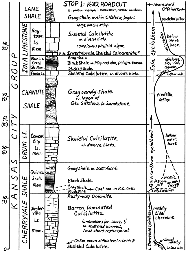
This stop shows well developed Iola cyclothem in open marine facies belt. Cherryvale-Drum sequence below is the most poorly exposed, thus least known part of Kansas City Group away from here. It is not known if either of the two less well developed cyclothems here represents a major marine inundation.
Westerville Limestone is a regressive limestone with skeletal calcilutite capped by barren laminated calcilutite, which contains birdseyes and mudcracks nearby and records shallowing of water to a muddy tidal shoreline. Eastward, oolite records the zone of water agitation between these two facies. Southwestward a small phylloid algal mound underlies the oolite, which is capped by thin skeletal calcilutite that may record a marine lagoon. The Westerville displays the variety of shallow-water facies typical of regressive limestones in this small area alone.
Quivira Shale has a thin blocky underclay-like mudstone at the base that is overlain by a thin coal nearby. Gray and black sparsely fossiliferous shales above record a transgression. Although the black shale carries conodonts that characterize only offshore core shales in other Missourian cyclothems, phosphate nodules are not reported. Thus it is uncertain whether the upper Quivira records a nearshore low-oxygen environment colonized by low-oxygen open marine conodonts, or maximum transgression and quasi-estuarine circulation with no transgressive limestone because carbonate-producing organisms were inhibited from growing on a submerged coal swamp.
Drum Limestone is entirely skeletal calcilutite recording a quiet open marine environment throughout, as is typical of some regressive limestones in the open marine facies belt where prodeltaic detrital influx often overwhelmed carbonate production below effective wave base. Cement City Member is a local name preferable here to Drum, a southeast Kansas name (Stop 9) that has been correlated tenuously all over the Midcontinent.
Chanute Shale records advance of prodeltaic clastics, with marine fossils reported nearby. Southward, thick sandstones and coal record delta-plain environments.
Paola Limestone is skeletal calcilutite with diverse biota recording quiet water below effective wave base. It is traced with little change from Iowa to Oklahoma, a typical transgressive limestone at the base of the Iola cyclothem.
Muncie Creek Shale is the core shale of the Iola cyclothem. Black shale with phosphorite nodules records anoxic phosphate-rich bottom conditions developed under quasi-estuarine circulation with upwelling during maximum transgression. Gray shales above and below record low bottom oxygenation developed as the quasi-estuarine cell was forming and as it was breaking up.
Raytown Limestone is the regressive limestone of the Iola cyclothem. The basal invertebrate calcarenite shows no cross-bedding or grain abrasion and lacks algal grains and micrite envelopes, with only forams encrustating some grains. This bed records accumulation of invertebrates in quiet water below effective wave base and probably below the effective limit of algal activity as well. The rest of the Raytown is skeletal calcilutite with conspicuous phylloid algae recording deposition in water shallow enough for algae, but still below effective wave base, even at the top.
Lane Shale records another advance of prodeltaic clastics into a quiet marine environment below effective wave base.
Leave Stop 1 at 7:55 A.M.
Drive 55 miles (E to 1-635, S to US 69 4 S 18 mi. past Louisburg) (70 min.).
Wyandotte Ls. btw. 179th 4 199th St. exits; Dennis Ls. S of Louisburg.
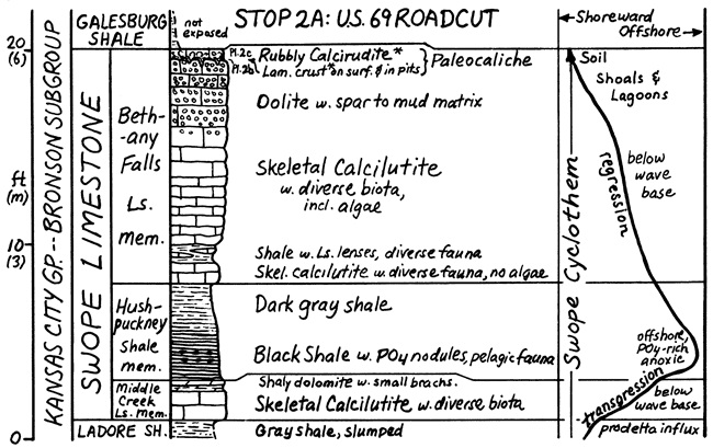
This stop shows the Swope cyclothem in the open marine facies belt (see also Mossler, 1973), a typical Kansas cyclothem like the Iola at Stop 1, but with distinct regressive shoal-water facies and a paleocaliche horizon at the top.
Ladore Shale is thin prodeltaic shale here, with sandstone and coal to the south.
Middle Creek Limestone is a typical transgressive limestone at base of Swope from Iowa to southeastern Kansas. Skeletal calcilutite with diverse biota records quiet water below effective wave base. Origin of thin dolomite bed at top seems more related to associated shale than to supratidal or fresh-water mixing models.
Hushpuckney Shale is a typical core shale, with phosphatic black facies recording anoxic phosphate-rich bottom conditions developed under quasi-estuarine circulation during maximum transgression, and gray shale above recording low bottom oxygenation developed as the quasi-estuarine cell was breaking up.
Bethany Falls Limestone is a distinctly regressive limestone. Lower two-thirds is mostly skeletal calcilutite with diverse biota recording quiet water below wave base. Basal calcilutite contains encrusting forams on unabraded grains and lacks preserved algae. Upper third is mostly oolite with pellets and partly with mud matrix, which records shallowing to shoals with sediment mixing into associated quiet lagoons. Most ooids are blocky calcite; downward displacement of nuclei in some suggests dissolution of aragonite and void-filling, which is compatible with nature of capping bed. A thin laminated siliceous crust fills small karst-like pits in the oolite. "Rubbly" limestone bed above carries poorly sorted, pelleted to vaguely pisolitic mud "clasts" that display irregular accretionary layers on the outside; both crust and rubbly bed represent a layer of paleocaliche that records subaerial exposure at the end of Swope regression.
Leave Stop 2A at 9:4S A.M.
Walk 0.3 mile down E side of US 69 (10 min.).
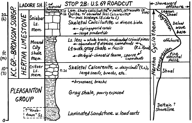
This stop shows the less characteristic Hertha cyclothem near the base of the Missourian in the open marine facies belt. Although recording a marine inundation that is traced from Iowa to southeastern Kansas, the Hertha has an atypical transgressive limestone and lacks a phosphatic black facies in the core shale.
Top of Pleasanton Group includes sandstone overlain by shale with marine fossils at the top that records marine inundation of a detrital, possibly deltaic, shoreline.
Critzer Limestone is skeletal calcarenite with abraded grains, micrite envelopes and abundant dasyclad algae, recording agitated sunlit water above effective wave base; micritic coatings on grains have only subordinate encrusting forams, thus may be largely algal in origin. The Critzer has been traced over only 1 county in Kansas, thus represents a local carbonate shoal developed early in the Hertha transgression.
Mound City Shale is the core shale of the Hertha cyclothem. Lower half carries few conodonts and derbyid-chonetid-dominated fauna like that found elsewhere in thin prodeltaic nearshore shales. Upper half carries a thin lens of unabraded invertebrates and an abundant diverse conodont fauna including forms present in the gray to black phosphatic facies in other cyclothems. This sequence probably records a weak fine detrital pulse followed by water deepening possibly below limit of much algal activity but short of depths required for development of quasi-estuarine circulation cell.
Sniabar Limestone is a typical regressive limestone that is mostly skeletal calcilutite with a diverse biota recording quiet marine water below wave base. Near the top, calcarenite with ooids and abraded skeletal debris (some osagia-coated) records shallowing into the zone of water agitation. Some ooids are partly dolomitized. At top (along E side) a thin, pelleted calcilutite with ostracode-dominated biota records a local protected lagoon developed late in regression.
Leave Stop 2B at 10:25 A.M.
Drive 51 miles (S on U.S. 69 past Pleasanton, W on K52 through Mound City, Blue Mound, Kincaid; S on U.S. 59, 4.3 mi. past Mildred (65 min.). Hertha and Swope, little changed from Stop 2, are exposed in roadcut past Mound City; Iola mound facies is exposed around Mildred.
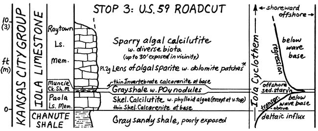
This stop shows the Iola cyclothem in the algal-mound facies belt. The Iola is presently under doctoral study by Iowa student John Mitchell, who provided much of the information for the following:
Chanute Shale is reported to approach 70 ft. in thickness in this vicinity, with sandstone and coal recording a delta plain environment.
Paola Limestone is still a typical transgressive limestone little changed from Stop 1, 80 miles away. At the base, however, is thin sandy skeletal calcarenite with slightly abraded fossil debris displaying micrite envelopes, which records passage of the zone above wave base early in the transgression. Above is typical skeletal calcilutite with phylloid algae recording quiet photic water below wave base. Algal remains become very rare in the top, however, suggesting deepening to the lower limit of the photic zone.
Muncie Creek Shale is very thin gray shale with abundant phosphorite nodules (especially conspicuous on floor of abandoned quarry just north of the roadcut), abundant conodonts, and little detrital quartz or macrobenthic fossils, all the characteristics of a core shale except the black fissile facies. It records essentially sediment starvation at maximum transgression, with phosphate-rich bottom water due to establishment of the quasi-estuarine circulation cell, which here had not totally depleted bottom oxygen, possibly due to higher position of the entire Iola over the much thicker Chanute delta plain in this area compared to the thin Chanute prodelta in northeastern Kansas.
Raytown Limestone still has the thin basal invertebrate calcarenite that shows neither grain abrasion nor micrite envelopes, thus probably records some shallowing with return of enough bottom oxygen for invertebrate proliferation short of the photic zone. Just above, phylloid algae join the invertebrates and become abundant enough to shelter spar-filled voids and form sparry algal calcilutite, the characteristic facies in the algal-mound belt, which records shallowing into the photic zone short of wave base. Largely algal sediment production in this environment was responsible for producing about 30 feet of mound facies exposed in nearby quarries; the top of the Raytown, however, is unknown in this region.
A lens of "algal sparite" 30 feet long and 3 feet thick in this roadcut displays dull cloudy brown calcite crystals with bright rusty-weathering patches of ferroan dolomite that are darker at the base. Scattered buff patches of calcilutite in the sparite suggest initiation-of this facies by lack of much mud deposition on the algal blades and other skeletal secretions. Relict radiating bundles of needle-like crystal ghosts within the calcite crystals suggest early precipitation of botryoidal aragonite spar that neomorphosed to irregular blocky calcite. Remaining or newly formed voids became partly filled by geopetal material that eventually solidified to the small dolomite crystals in the darker basal portions, whereas the remaining tops of the voids became lined or filled with larger dolomite crystals to form the distinctive rusty-weathering patches. The possible role of neomorphism of original mud sediment to sparite is not yet evaluated.
Leave Stop 3 at 12 Noon (Lunch on Bus)
Drive 43 miles (S on U.S. 59 to Moran, W on U.S. 54 to Iola, S on U.S. 169 past cut of Lane-Bonner Springs Shale on left [Wyandotte Ls. has disappeared southward at latitude of Stop 2], across large Monarch. Cement quarry in Iola mound facies S of Humboldt, W on K39 in Chanute past Ash Grove Cement quarries in south end of Iola mound, past thin non-mound Plattsburg, up low Stanton escarpment, and past junction with U.S. 75 to Wilson Co. St. Lake) (60 min.).
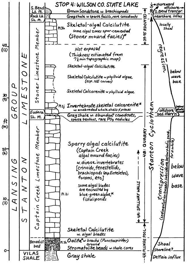
Stops 4, 5, 6, 8, and 10 are in the Stanton Limestone, recently the most intensively studied Missourian formation in Kansas (Heckel, 1975, 1975a; Senich, 1975, 1978; Wood, 1977; Brondos 1978). Stratigraphic classification in northeastern Kansas is given in Figure 9; stratigraphic classification and facies relations in southeastern Kansas are given in Figures 10-16, which are adapted from Heckel. (197S). More detailed description and interpretation of the formation follow the descriptions of field trip stops.
Figure 9--Stratigraphy of Stanton Limestone in open marine facies belt of northeastern Kansas, showing included cyclothems (modified from Heckel, 1975a, Fig. 3A).
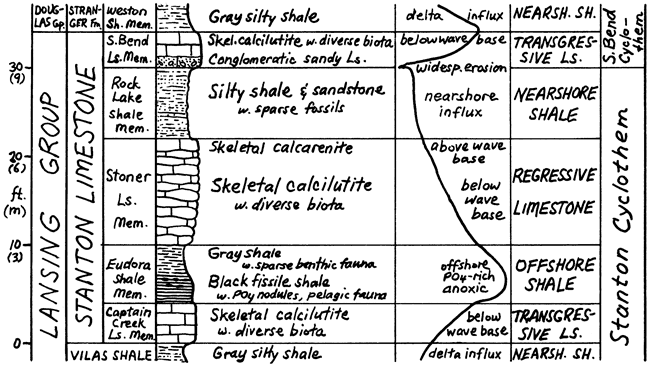
Figure 10--Outcrop and facies regions of Stanton Limestone in algal mound facies belt in southeastern Kansas (modified from Heckel, 1975, p. 45).
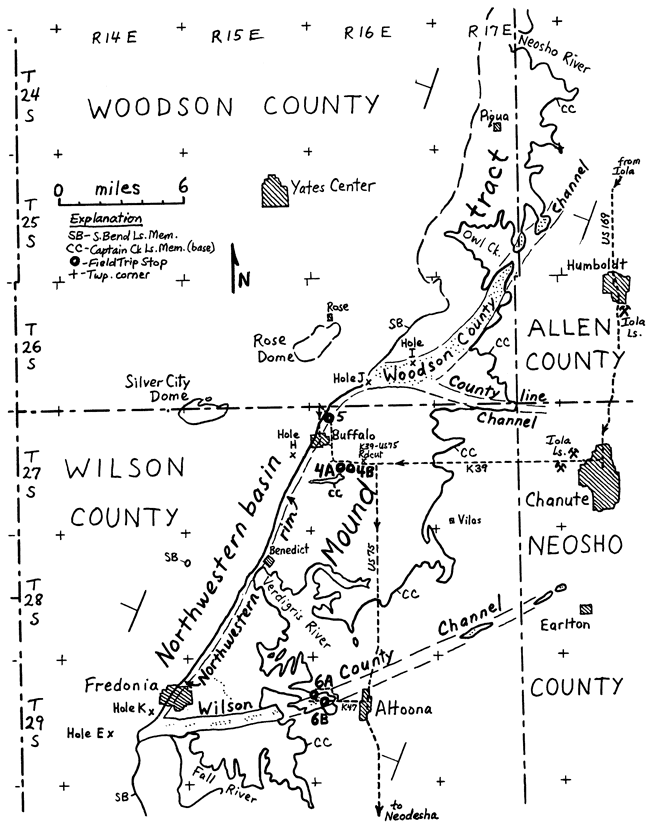
Figure 11--Cross section showing subdivisions and facies of Stanton Limestone across algal mound facies belt in southeastern Kansas (modified from Heckel, 1975, p. 48).
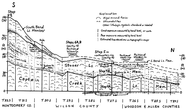
Figure 11a--East-west cross section through north end of detrital belt (see Fig. 15, 16).
Unload bus in lane W of spillway bridge; walk S down spillway (15 min.).
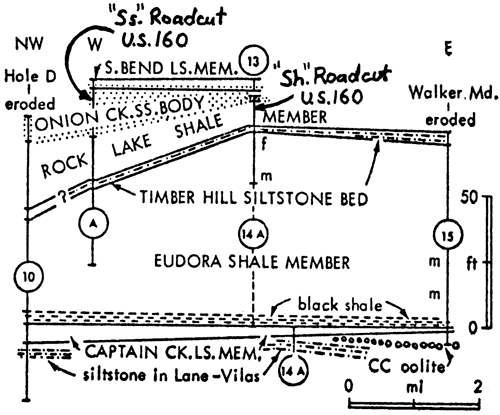
This stop shows one of the few transgressive calcarenites and part of the thickest transgressive phylloid algal mound in the Kansas Pennsylvanian.
Vilas Shale is a thick sequence of rapidly deposited sandy mud probably as a deltaic complex building westward; final delta slope is preserved beneath northwestern rim of Stanton buildup (Fig. 10, 12), seen at Stop 5.
Benedict bed here consists of spar-cemented oolite surrounding large shale-cored stromatolite heads; the oolite disappears eastward, and the stromatolite disappears westward. Though no definite algae have been detected in thin section, stromatolites locally carry encrusting forams and a few brachiopods and snails, and probably represent nonskeletal algal mat development during initial marine inundation of the Vilas delta platform. Oolite records the zone of agitated water focused along northwest edge of platform during early transgression. Ooids display ghost lamellar structure in blocky calcite crystals, thus record direct inversion from aragonite in transgressive environment where subaerial dissolution never occurred. Thin shale above records last detrital pulse from delta.
Captain Creek Limestone, with Benedict bed, is the transgressive limestone of the Stanton cyclothem. It is skeletal calcilutite with relatively diverse marine biota dominated by blades of phylloid algae that often shelter spar-filled voids with geopetal sediment in the base. This "algal-mound facies" records quiet water below wave base but above the effective photic limit for this kind of algae. Phylloid algae include red and green forms in which internal structure has been obliterated by neomorphism and/or dissolution-void-fill. Locally, blue-green algal filaments encrust the phylloid algae.
Leave Stop 4A at 2:00 P.M.
Walk 0.5 mi., up spillway and E below highway level to quarry (20 min.).
This stop shows offshore facies of the Stanton cyclothem in the algal mound facies belt, from the upper part of the transgressive limestone through the lower part of the regressive limestone.
Captain Creek is sparry algal calcilutite (typical algal mound facies) through its entire 25-ft thickness, which records transgression slow enough for much more algal blade and mud production within the photic zone than during other major inundations in Kansas.
Thin gray Eudora Shale with abundant diverse conodont fauna typical of other core shales, scattered benthic invertebrates, and rare phosphorite nodules records sediment starvation at maximum transgression with quasi-estuarine circulation and upwelling, but above the level of anoxic bottom water, which is confined in this facies belt to topographically low channel axes (Figs. 10, 13) where the transgressive limestone is thin (Stop 6B).
Stoner Limestone is the regressive limestone of the Stanton cyclothem. It has invertebrate calcarenite at base with no cross-bedding, grain abrasion, or evidence of algal activity; what little micritization is detected in grains is internal, thus probably fungal. Upper beds display phylloid algae from 4 ft. above base, suggesting shallowing to above base of photic limit for these algae. Top of Stoner exposed in K39-U.S. 75 roadcut just to east has abundant algae, some in spar-cemented zones, suggesting further shallowing to wave base.
Leave Stop 4B at 2:50 P.M.
Walk back across highway to bus, which leaves at 3:00 P.M.
Drive 4 miles (W & N on US 7S to downgrade past Buffalo turnoffs) (5 min.).
This stop shows the thick development of skeletal calcarenite in the top of the regressive limestone (Stoner Member) along the northwest rim of the Stanton mound tract.
Regional dip, which is generally 30 feet/mile to WNW across the mound tract, increases abruptly at this place to about 6 to 7 times as much (about 20; locally up to 100) to form a rim to the algal buildup (Fig. 12). This rim coincides with final delta-front slope of the underlying Vilas Shale and forms a gentle but noticeable westward-facing escarpment from here to Fredonia, 15 miles to the southwest (Fig. 10).
Figure 12--Stratigraphic and facies relations across northwestern rim of Stanton mound tract near Buffalo (modified from Heckel, 1975, p. 47).
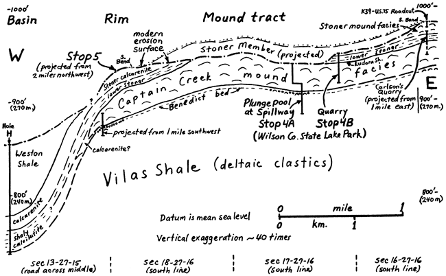
The upper part of the Stoner Member changes facies from phylloid algal mound facies on the central mound tract (K39-US-75 Roadcut, E of Stop 4B) to skeletal calcarenite along the rim. In contrast to the basal calcarenite seen at Stop 4B, the calcarenite exposed here shows both grain abrasion and small-scale cross bedding, reflecting water agitation and traction transport of sediment; in places it shows large-scale megaripples, a common bedform on shoals in the zone of wave action. Spar cementation is pervasive often with drusy rims around grains. Fossils include fragments of phylloid algae (especially Archaeolithophyllum), solenporid red algae (Heckel, 1975b),and dasyclad green algae, in addition to echinoderms, fenestellid, fistuliporid, and rhomboporid bryozoans, brachiopods, pelecypods, gastropods, foraminifers (including fusulinids), ostracodes, scattered calcisponges and corals. Many grains have micrite envelopes, which are particularly noticeable on echinoderms and sparry molluscan and algal grains. All these features point to shallowing of the sea bottom above effective wave base over a broad area along this edge of the mount tract, where waves dissipated their energy on this shoal before moving eastward over the quieter environment of the calcilutitic algal mound facies around Stop 4.
Northward down the road ditch, diversely fossiliferous skeletal calcilutite dips off the rim; whether lower Stoner (thus representing an earlier stage of regression) or upper Stoner in a lower position on the rim, this records deeper water below effective wave base. The area northwest of the rim is considered a "basin" because no nearby opposite side is detected for it to be considered a channel. Corehole data show that the Stanton in the basin is mainly shaly calcilutite with a diverse invertebrate fauna (especially whole bryozoans of all types, brachiopods, echinoderms and calcisponges) and little or no algae, all reflecting quiet water below wave base. Zones near the tops of the cores consist of spar-cemented calcarenite with algal blades and may represent material washed periodically down from the rim.
Leave Stop 5 at 3:30 P.M.
Drive 21 miles (N to 1st left, next left S through Buffalo, E to U.S. 75 4 S to Altoona; W on K47 across river, then 1st N, 1st W & S on gravel roads) (30 min.). Descend Stanton escarpment over thick Vilas Shale at about 13 miles.
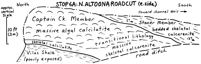
This stop shows facies change from Captain Creek algal mound into channel-margin calcarenite along north side of major east-west (Wilson County) channel.
Captain Creek algal mound facies thins southward from 12 feet to disappearance along middle of cut, as basal skeletal calcilutite grades to calcarenite and thickens complementarily. Bedded Stoner skeletal calcarenite overlies thin finger of mound facies in middle of cut and dips southward toward channel axis. Eudora Shale is very thin or absent. As Captain Creek algal mound facies grew vertically in response to water deepening, it extended laterally very little into the channel. Basal unit is one of few known exposures of Captain Creek mound-flank calcarenite, which contains calcilutite clasts derived nearby from tops of algal blades in mound facies.
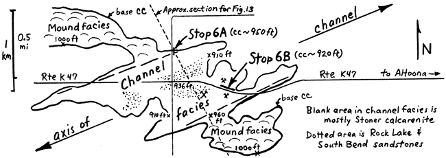
Carbonate channel facies lie at least 80 feet (25 m) below equivalent mound facies on either side (Figs. 13, 14). Channel is traced from outliers northeast of Altoona westward 22 miles to Fredonia (Fig. 10). Averaging 0.7 mile wide, it forms a noticeable topographic low in the main outcrop belt toward Fredonia where a small creek flowing down it exposes Stanton channel facies at the same elevation that tributaries cutting Stanton mound facies expose underlying Vilas Shale. Most channel fill is Stoner calcarenite, but reddish Rock Lake quartz sandstone (exposed on way to Stop 6B) and gray South Bend fossiliferous quartz sandstone and sandy calcilutite overlie Stoner along channel axis.
Figure 13--Stratigraphic and facies relations across major channel in Stanton mound tract (modified from Heckel, 1975, p. 46).
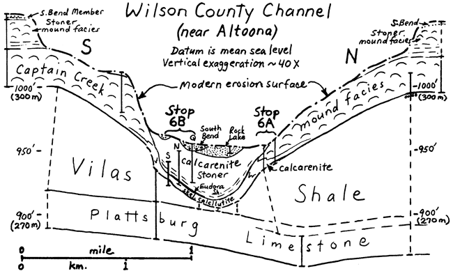
Figure 14--Map of Altoona roadcuts (Stop 6) in Wilson County channel (modified from Heckel, 1975, p. 56).
Leave Stop 6A at 4:25 P.M.
Drive 1 mile (S, & E on K47) (5 min.) Rock Lake sandstone on left at junction.
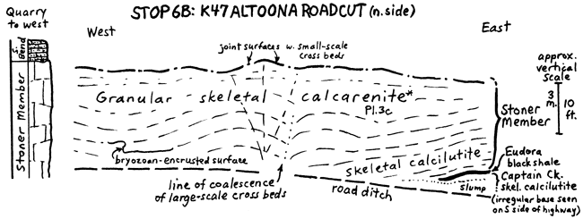
This stop shows Stanton channel facies near axis of Wilson County Channel.
Captain Creek is thin skeletal calcilutite in which diverse marine fauna and lack of Vilas clasts record deposition in quiet water below effective wave base. This suggests that the initial Stanton carbonate deposit merely conformed to preexisting channelled topography on the Vilas delta surface after terrigenous influx ceased in a continually subaqueous environment as sea water encroached into a formerly freshwater channel. No diagnostic delta facies are identified in Vilas, though.
Thin black Eudora Shale records greatly reduced deposition of finest suspended material in anoxic bottom environment developed in deepest water at maximum transgression. Black color disappears as shale rises 10 feet across highway toward south side of channel, which remained continually above the anoxic water layer.
Stoner Member, forming most of channel fill, is skeletal calcilutite at the base recording resumption of carbonate deposition in still relatively deep quiet water after anoxic bottom conditions disappeared as sea began to shallow. Upper Stoner is spar-cemented abraded-grain calcarenite that records increasingly well washed environment developed in channel as further shallowing caused waves and currents to impinge upon the bottom. Distinctive large-scale cross bedding in which up-arched beds coalesce laterally at edges, probably represents cross-sections of elongate lime-sand bars, parallel to sides of channel, that accreted upward through time with little movement toward sides of channel. Small-scale cross bedding locally shows bidirectional transport of tidal currents. Many organisms present as whole fossils (brachiopods, snails, corals, cephalopods) probably lived in the channel. Common articulated crinoid stems suggest rapid burial by a thick layer of debris during storms. Bryozoan-encrusted irregular surface indicates intermittency of deposition and periods of erosion. Many abraded grains have micrite envelopes and some have coatings as well. Crushed envelopes and coatings indicate dissolution and collapse of some grains. Brownish grains are ferroan dolomite, either replacement or void fill after grain dissolution.
Quarry to west (northwest corner) exposes lenses of Rock Lake sandstone and 5 feet of South Bend interbedded fossiliferous quartz sandstone and sandy calcilutite recording later channel fill, reworked in the succeeding transgression.
Leave Stop 6B at 5:45 P.M.
Drive 10 miles (E on K47, S on U.S. 7S) (15 min.) Non-mound Plattsburg Limestone below Stanton on K47; Chanute Sandstone along U.S. 75.
Dinner at Old Homestead Motel, U.S. 75 N, Neodesha,Ks.about 7:00 P.M.
Overnight Stop
Second day (Sunday) Leave Old Homestead Motel at 8:00 A.M.
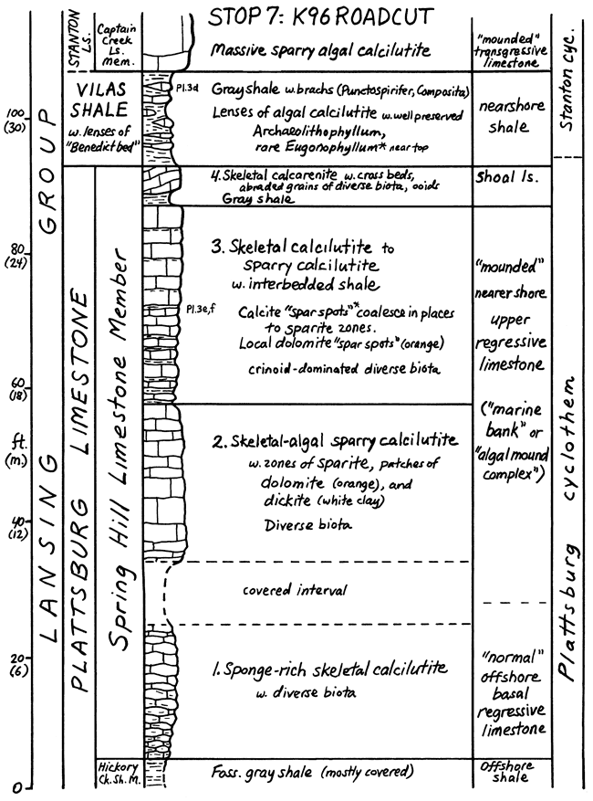
Drive 6 miles (S on U.S. 75 through Neodesha, W on K96) (10 min.). Lane-Bonner Springs nearshore shale below Plattsburg on left past junction.
This stop shows one of the most complex mound facies, that of the Plattsburg Limestone, the next cyclothem below the Stanton.
Spring Hill Member is the regressive limestone of the Plattsburg cyclothem. Although limited in areal extent to essentially the south half of Wilson County, this mound complex in the Spring Hill displays the greatest variety of facies known among buildups in Kansas. It is the original "marine bank" studied by Harbaugh (1959) and visited on earlier field trips (1962, 1965). This roadcut is presently under petrologic study by David L. Nelson, Iowa Master's candidate, who provided basic information on the four subdivisions of the Spring Hill Member:
Greatly thinned Vilas Shale records nearshore detrital pulses that finally swamped Plattsburg carbonate mound development. Influx was periodic enough in shallow water that phylloid algae, particularly Archaeolithophyllum, temporarily produced enough carbonate to form limestone lenses in the detrital environment.
Captain Creek massive algal mound records reestablishment of large-scale algal carbonate production after cessation of detrital influx, as sea transgressed again.
Leave Stop 7 at 9:20 A.M.
Drive 14 miles (W 1.4 miles on K96, S on gravel road, descending Stanton escarpment over thickened Vilas Shale (equivalent to Plattsburg mound), past thick Lane-Bonner Springs exposure at bridge, up over thin non-mound Plattsburg at curve, following high Stanton escarpment on right; W on paved road to Dam entrance, S and W past Dam Headquarters) (25 min.).
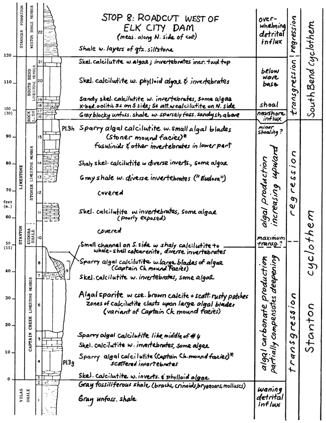
This stop shows mound development in all 3 Stanton carbonate members near south end of mound facies belt in thickest known section of Stanton Limestone.
Fossiliferous top of Vilas Shale (unit 2) records return of more open marine conditions after rapid nearshore detrital influx (unit 1).
Captain Creek skeletal calcilutite at base (unit 3) records initial marine carbonate deposition after sea transgressed enough to strand detrital influx farther away. Unit 4 records initial proliferation of phylloid algae to produce massive mound facies, with spar-filled voids containing pelleted geopetal mud fill beneath the algal blades. Compactional fracture is evident in mud and some skeletal fragments. Thin beds into lower unit 5 record temporary subdual of algae. Top of unit 5 plus unit 6 record major episode of algal proliferation to form massive mound facies as carbonate deposition kept sufficient pace with water deepening to keep bottom within photic zone for a substantial time. Most of unit 6 is "algal sparite" mound facies in which a) little mud was deposited, and b) early spar fillings and some later lime mud were largely recrystallized. Supporting a) are zones of calcilutite "clasts" deposited in depressions on top of large irregular algal blades; supporting b) are immense brownish strained calcite crystals that encompass algal blades, void space, partial fillings of botryoidal radial acicular spar, and former internal geopetal sediment (see later article in this guidebook). Unit 7 marks temporary subdual of algae before final phase of algal proliferation and similar sparite formation, mainly in obvious voids, recorded in unit 8. Unit 9 is a small channel that plunges southward off nearby edge of mound, and is filled with diverse unabraded invertebrate-rich shaly limestone, probably deposited in deeper water and possibly belonging to higher members.
Eudora Shale is not exposed other than possibly in small channel (unit 9).
Stoner skeletal calcilutite near base (unit 11) with scattered algae records quiet marine environment probably during initial regression. Unit 13 (fossiliferous gray "Eudora" shale) records substantial, but slow, fine detrital pulse. Unit 14 marks return of invertebrate and algal carbonate production, and unit 15 records sufficient shallowing to again initiate enough algal proliferation to produce massive mound facies at top. Some spar-cemented zones of algal blades near the top suggest eventual shoaling to above wave base.
Rock Lake Shale and sandstone (units 16-17) record detrital influx in nearshore to ?nonmarine environments across top of Stoner mound, ending Stanton cyclothem.
South Bend oolitic cross-bedded quartz sandstone at base (unit 18) records initiation of carbonate deposition in shallow agitated marine environment; thin layers of calcilutite abruptly overlain by sandstone suggest periodic washing of sand across mud (possibly tidal) flats. Higher units (19, 20, 21) record further transgression with deposition of skeletal calcilutite in quieter more offshore environment. Phylloid algae, though present, do not form as well developed mound facies here as westward (Qy. on US 160 at Elk R. bridge). Also westward, the shaly top of the South Bend has one of the most diverse invertebrate faunas in the Stanton, which suggests initial development of offshore shale in South Bend cyclothem.
Overlying Weston Shale records rapid detrital influx that overwhelmed offshore shale and any succeeding carbonate deposition and eventually caused nonmarine environments to aggrade across parts of eastern Kansas.
Leave Stop 8 at 11:00 A.M.
Drive 24 miles (W, S, W, N, W on paved roads to US 160 on E outskirts of Elk City, then S & E through Independence to 1 mile E of Verdigris River bridge) (30 min.).
Westward from Stop 8 we cross the plateau formed by Stanton algal mound facies near the south end of the algal mound facies belt (Fig. 15). In the large forested hill to the south (Timber Hill), all Stanton limestone members have greatly thinned or disappeared, and Eudora and Rock Lake clastics dominate the Stanton interval. The abrupt facies change into the terrigenous detrital facies belt occurs in all members of the Stanton (Fig. 16), and also along the same alignment, in the mound complexes of the older Dennis and Swope cyclothems.
Figure 15--Outcrop and facies regions of south end of Stanton Formation in southeastern Kansas (modified from Heckel, 1975, p. 44).
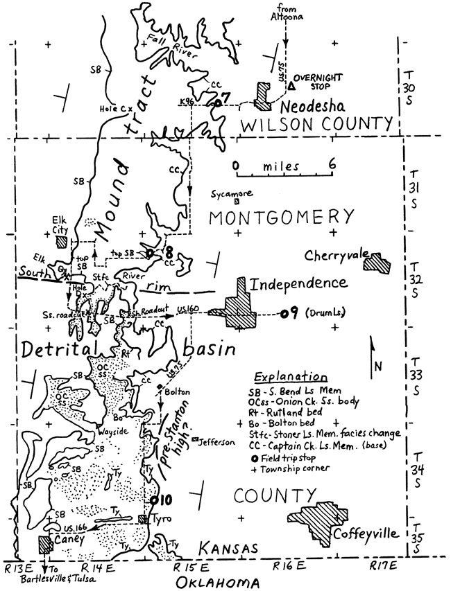
Figure 16--Cross section showing subdivisions and facies of south end of Stanton Formation across detrital facies belt in southeastern Kansas (modified from Heckel, 1975a, p. 8).
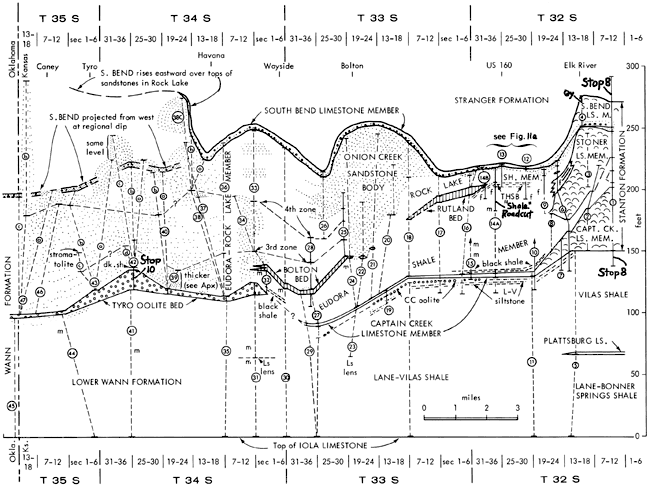
The quarry along US 160 just south of the Elk River bridge displays abrupt southward thinning of the South Bend mound. The upper South Bend in the north wall is 20 feet of massive algal mound facies, which thins southward (in about 300 feet) to 13 feet of bedded skeletal calcilutite with only subordinant algae.
Three miles farther along US 160 ("sandstone" roadcut, Fig. 11a), the South Bend has thinned to 4 feet of limestone. It overlies 18 feet of reddish-brown sandstone (Onion Creek body) above 17 feet of shale, both constituting the Rock Lake Member, which has thickened southward from 5 feet in the quarry at Elk River bridge to 35 feet here. This overlies a siltstone (Timber Hill bed, down in far creek bank on left) and 30 feet more of shale, assigned to the Eudora and equivalent to the upper Stoner Limestone, which has lensed out 1.5 miles to the north.
Two miles farther east a "shale" roadcut (Fig. 11a, 16) exposes fossiliferous shale, assigned to the Eudora, that can be traced northward to the Stoner pinchout, thus indicating southward replacement of the regressive limestone by marine clastics in the detrital facies belt. In the top of the cut, Rock Lake shale and sandstone have thinned to about 12 feet. Less than a mile to the east, the transgressive limestone (Captain Creek) is exposed; it has thinned to only about 3 feet from 50 feet at Stop 8, just 4 miles north. The small hill in the distance on the right is Walker Mound, where black phosphatic shale, which has reappeared at the base of the Eudora, marks maximum transgression over thin Captain Creek.
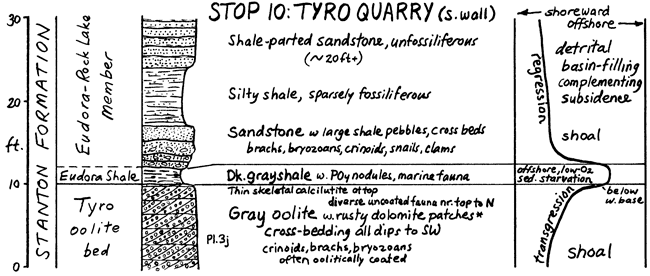
This stop shows the Drum Limestone, an oolite with oomoldic porosity.
The Drum is spar-cemented oolite calcarenite with fossils common in certain zones. Most of the ooids are now molds largely unfilled by later spar. Oomoldic porosity is significant in many petroleum reservoirs of this age in the subsurface of western Kansas. The ooids probably were preferentially removed because they were originally aragonite. In support, originally aragonitic fossils such as clams and snails also are molds, whereas fossils known to be originally calcite (echinoderms, brachiopods and bryozoans) are still intact. Some of the remaining ooids are neomorphic microspar that retains concentric structure; others are coarser clear blocky spar that probably resulted from void filling (Pl. 3i).
The Drum is named from this area, where it locally is 50 feet thick. Just 0.3 mile to the east (on the right past the road junction) it has thinned from 18 feet at Stop 9 to 1 or 2 feet in a shale and sandstone sequence; yet the name Drum has been carried north to Kansas City and even to Iowa. Although thin limestone is reported near this horizon locally in eastern Kansas, lack of recent detailed study of this interval suggests that limestones called Drum around Kansas City and north probably should be referred to by local names that have priority (e.g., Cement City).
Leave Stop 9 at 12:00 noon (Lunch on bus)
Drive 21 miles (W through Independence, S on U.S. 75, 5.5 mi. to paved road; S 2.3 mi., W 1 mi. past Bolton bed [equivalent to lower Stoner] above Eudora Shale on right; S 5 mi. [past Bolton bed again on left and over hills formed by Stanton detrital rocks], then E on gravel road to end) (30 min.).
This stop shows the core of the Stanton cyclothem in the terrigenous detrital facies belt.
Tyro oolite bed is equivalent to the Captain Creek Member and is one of the few Missourian limestones that can be walked across the Oklahoma border. Quartz grains nucleate most ooids in the Tyro. Oolitic coatings seem well preserved at some localities, but here in local patches and bands, all the coatings and sometimes the sparry cement have been replaced by finely crystalline ferroan dolomite to produce "tigerstone" and "leopardstone" lithologies.
Cross beds here and at other localities dip consistently to the southwest. Oolitic coatings tend to be thinnest in the northeastern-most exposure and thickest in the western-most exposure. Above criteria, along with locally higher regional dip in conjunction with eastward thickening of pre-Tyro strata in northeastern-most outcrop, indicate that Tyro ooids were initially generated on a northeastward shoal from which they were carried by currents, still accreting, to the southwest to form the present deposit (Fig. 15). Thus the Tyro initially records an early stage of transgression in an environment of water agitation like the oolite facies of the Benedict bed. Lessening of agitation, probably from deepening during Tyro deposition, is suggested by diverse fauna, not oolitically coated, discovered by Senich (1978) in the upper Tyro in the north side of the quarry. Later transgression to depths below effective wave base is recorded in about 1 cm of skeletal calcilutite at the top of the Tyro in the south wall.
Dark gray Eudora Shale carries phosphorite nodules and pelagic and benthic fauna of abundant conodonts, cephalopods, echinoderms, brachiopods, ostracodes, and foraminifers. It records slow deposition during maximum transgression, below wave base but just above the top of the anoxic water layer that was located farther to the north.
Overlying sequence is termed Eudora-Rock Lake because of southward disappearance of marker units separating the two members. Fossiliferous sandstone at base with shale pebbles is a local unit absent across the quarry. Cross bedding in it indicates traction transport of sediment and suggests shoal deposition during a later stage of regression. Overlying sparsely fossiliferous shale and sandstone probably represent deltaic influx.
Leave Stop 10 at 1:10 P.M.
Drive 180 miles (W & S through Tyro, W on U.S. 166 to Caney, S on U.S. 75 to Bartlesville and Tulsa; thence to Oklahoma City, arriving about 4:30 P.M.).
In the years since the pioneering work of Wilson (1957a, b) and Harbaugh (1959, 1960, 1962) on the Upper Pennsylvanian algal carbonate buildups ("reefs," "marine banks") in southeastern Kansas, new exposures and detailed field mapping have greatly extended our knowledge of distribution of buildups and associated facies in the Stanton Limestone of this region. Most significant perhaps is the discovery of extensive contemporaneous channel and flank deposits that respectively transect and rim the areas of buildup. Furthermore, advances in knowledge of modern carbonate environments and of the cyclic sequence of environments through the Upper Pennsylvanian section have fostered better understanding of the reasons for development of the various facies associated with the Stanton carbonate buildups.
Since Harbaugh's (1965) last formal field trip to this area, the general nature of phylloid algal buildups in eastern Kansas has been established by Heckel and Cocke (1969), the distribution of channel and rim facies among the buildups in the Stanton Formation has been compared with some modern analogs by Heckel (1972a), and the southern gradation of Stanton buildups into shale, sandstone, and thin limestones of the terrigenous detrital facies belt in central Montgomery County has been documented by Heckel (1975a). Paleontological work on the Stanton of this area, initiated by Newell (1933), more recently has been supplemented and refined by Wray (1964) and Heckel (1975b) on the red algae, by Senich (1975) on biotic differentiation among the buildup, channel and rim facies, by Wood (1977) on the conodonts, by Brondos (1978) on the ostracodes and foraminifers, and by Senich (1978) on the macroinvertebrates, particularly brachiopods, gastropods and pelecypods. Work is in progress by J.M. Cocke on the corals, D.F. Toomey on the sponges, R.K. Pabian and H.L. Strimple on the crinoids, and work is planned by T.J. Galvin and F.K. McKinney on the bryozoans. The work of Wood (1977) on Stanton conodonts (see also Wood and Heckel, 1977)is built on the description of Missourian conodonts of Kansas by Baesemann (1973), which had led to the vertical analysis of conodont faunas and lithologies by Heckel and Baesemann (1975) and eventually to the sedimentological explanation of the cyclic sequence by Heckel (1977).
In the open marine facies belt of northeastern Kansas, the Stanton is divided into five members comprising three limestones separated by two shales (Fig. 9). The lower three members (Captain Creek, Eudora, Stoner) plus the adjacent parts of the underlying and overlying shales (Vilas, Rock Lake) constitute a typical Kansas cyclothem in terms of both lithology and conodonts. The South Bend Limestone Member at the top, however, formerly considered a "super" limestone member, shows lithologic and conodont characteristics of a "middle" limestone member and thus apparently records the transgressive phase of a higher cyclothem (here termed South Bend) that was overwhelmed by Douglas Group clastics before succeeding "core" shale and "upper" limestone members could develop.
The upper part of the Vilas Shale is the nearshore shale that initiates the Stanton cyclothem. In the Kansas City area the Vilas consists of about 6 m of gray shale with thin beds of siltstone. Macrofossils occur mainly at the top, and the conodont fauna (collected only at the top) is strongly dominated by Adetognathus.
The Captain Creek Limestone Member is about 1.5 m of medium-bedded skeletal calcilutite carrying a diverse marine biota that includes brachiopods, bryozoans, echinoderms, clams, snails, fusulinids, small corals and blades of phylloid algae. Conodont faunas consist of Adetognathus and Anchignathodus (formerly Ozarkodina) at the base with Idiognathodus appearing upward and becoming dominant at the top. Although it is somewhat thicker than most, the Captain Creek has all the characteristics of a transgressive limestone.
The Eudora Shale Member in northeastern Kansas is about 1.8 m of gray to brown shale with most of the lower half consisting of the black platy organic-rich facies carrying phosphorite laminae and nodules. Marine benthic invertebrates are scattered through the top, but only marine pelagic fossils, mainly conodonts, fish scales, and orbiculoid brachiopods (which may have been epipelagic), are found in the black facies. Conodont faunas are the most abundant and diverse in the entire Stanton and are strongly dominated by Idiognathodus. Most significant is the unique occurrence in the entire Stanton in northeastern Kansas of Idioprioniodus and Gondolella, interpreted to be deeper water forms (Heckel and Baesemann, 1975). The Eudora has all the characteristics of a typical offshore shale.
The Stoner Limestone Member is about 3.6 m of thin to medium-bedded skeletal calcilutite grading upward to abraded calcarenite in the Kansas City region. The diverse assemblage of macrofossils is dominated by brachiopods, echinoderms, bryozoans and fusulinids. Conodont faunas are sparse and dominated by Idiognathodus with scattered Anchignathodus, Aethotaxis and Adetognathus. The Stoner displays the characteristics of a regressive limestone in the open marine facies belt, particularly the upward change from calcilutite to calcarenite, which records some shallowing to above wave base, and the lack of shoreline facies at the top, which are typical only in the more shoreward facies belts. (This lack of really shallow-water deposits also explains the apparent lack of vertical change in the conodont faunas of the Stoner.) By contrast, in the northern shoreward facies of Nebraska, the upper Stoner displays dolomitic poorly fossiliferous calcilutite interpreted as a tidal-flat environment by Russell (1972).
The Rock Lake Shale Member is about 2.4 m of light brown silty micaceous shale in the Kansas Turnpike exposure, but varies laterally from 1 to 4 m and contains in places clay shale, impure platy limestone, and reddish sandstone, a situation of lateral heterogeneity that is not surprising in nearshore shales. Tracks, trails and burrows are the only fossils found with regularity, although clams are abundant locally, and land plants and brackish-water invertebrates were found near Garnett in east-central Kansas (Moore, et al., 1936). Conodonts from the Turnpike section (Fig. 9) consist of only a few Idiognathodus confined to the lower and middle parts. This is compatible with the lack of shoal-water facies at the top of the underlying Stoner and suggests that the influx of Rock Lake clastics overwhelmed Stoner carbonates in the subtidal environment, as would be expected for nearshore shales in the open marine facies belt. In support, trace fossils in the Rock Lake in northeastern Kansas indicate a marginal marine environment (Hakes, 1975). In the northern shoreward facies in Nebraska, on the other hand, the lower Rock Lake consists largely of unfossiliferous reddish mudstone deposited high on a tidal flat, according to Russell (1972); he notes also that this is overlain by mudstone to sandstone with marine fossils that mark the beginning of the succeeding transgression.
The South Bend Limestone Member, about 1.5 m thick along most of the Kansas outcrop, consists of a twofold lithologic subdivision. At the base is a heterogeneous unit of locally cross-bedded calcareous quartz sandstone to conglomerate with pebbles of calcilutite, shale, sandstone, chert, wood fragments, and occasional marine fossils. This is overlain by a homogeneous medium-bedded skeletal calcilutite with a diverse marine fauna of brachiopods, bryozoans, echinoderms,fusulinids, mollusks and scattered corals. Conodont faunas range from absent in the base to Adetognathus-dominated in the lower middle to Idiognathodus-dominated in the upper part. The vertical trends in both lithology and conodonts strongly support the transgressive nature of the South Bend, which is further corroborated by Russell (1972) and Hakes (1975). In fact, about the only departure of the South Bend from other transgressive limestones is the well developed shoal-water facies at the base. This probably reflects the widespread withdrawal of the sea indicated from Nebraska to southernmost Kansas late during Rock Lake deposition, which resulted in widespread subaerial erosion and accumulation of many types of residual material that were then incorporated into the initial deposit of the transgressing South Bend sea.
This field trip will visit the Stanton Formation only in the phylloid algal mound and terrigenous detrital facies belts in southeastern Kansas, where all three limestone members thicken into mound complexes and where all members show more or less abrupt and radical facies changes across topographic differences associated with the mounds.
Facies in each member of the Stanton Formation in the algal mound facies belt are strongly related to paleotopographic features associated with the mound complexes, which are detectable as modern.topographic features either by casual observation or by detailed mapping (Fig. 10, 15).
Most of the Stanton outcrop in the phylloid algal mound facies belt is developed on the mound buildup tract, a regional topographically high plateau that extends along the common boundary of Allen and Woodson counties diagonally across central Wilson County into northwestern Montgomery County. It is bounded on the east by the prominent erosional escarpment held up by the Stanton over thick nonresistant Vilas shale and on the west by the erosional limit of younger covering rocks, which along the central portion of outcrop in northern Wilson County coincides with the northwestern rim to the buildup. Its south end is marked by abrupt southward thinning of the algal mound complexes in all limestone members into the detrital facies belt across the Elk River Valley in west central Montgomery County, and its north end is probably a more gradational thinning of the limestone members into the open marine facies belt north of the Allen County line in Anderson County. The buildup tract is transected in southeastern Woodson and central Wilson counties by two major contemporaneous channel systems. Across the mound tract in northwestern Montgomery County, all three limestone members are developed mostly as phylloid algal mound facies, as seen at Stop 8. Northward only the Captain Creek and Stoner maintain this facies development (seen at Stop 4), whereas the South Bend thins to open marine facies. A layer of stromatolites that we will see at Stop 4A (the Benedict bed; see later section) underlies the Captain Creek mound in this northern region. The Eudora consists of a thin layer of gray shale between thick-bedded to massive Captain Creek mound facies and thinner bedded basal Stoner wherever exposed across the buildup tract, as we will see at Stop 4B.
Transecting the buildup tract and lying as much as 70 to 90 ft. (21 to 27 m) topographically lower along strike than the mound facies are two major channel systems. The more southerly one, the Wilson County channel, is 0.5 to 1 mile (1-1.6km) wide and is traced for at least 22 miles (37 km) west-southwestward from outliers in west central Neosho County across the middle of Wilson County past Altoona to southwest of Fredonia (Fig. 10). It contains a thin sequence of Captain Creek skeletal calcilutite and Eudora black shale at the base and is filled mainly with Stoner skeletal calcilutite and particularly calcarenite (Fig. 13), all of which we will see at Stop 6B. At Stop 6A the facies change on the north side of the channel is exposed. In places are later channel fillings of ferruginous Rock Lake sandstone and calcareous conglomeratic South Bend sandstone.
The main branch of the more northerly system, the Woodson County channel, is about 1 mile (1.6 km) wide and extends 12 or possibly 15 miles (20 to 25 km) from outliers in west central Allen County curving gently southwestward across southeastern Woodson County. It contains locally thick conglomeratic oolite at the base (assigned to the Benedict bed) overlain by thin Captain Creek algal calcilutite, Eudora black shale, and Stoner skeletal calcilutite. Parts of it are lined by Stoner calcarenite, but the greater part of the channel fill consists of up to 21 m of Rock Lake shale and sandstone with individual sandstone bodies up to 11 m thick. Only tracing of the thin distinctive South Bend Member over the top of this thick channel fill, which previously had been mapped as post-Stanton clastics, allowed it to be assigned to the Rock Lake Member.
A southern branch to the Woodson County system, the County-line channel, is about 0.5 mile (1 km) wide and extends at least 5 miles (8 km) from the common juncture of Allen, Woodson, Wilson and Neosho counties west-northwestward across the Wilson-Woodson line to meet the Woodson County channel. The County-line channel contains thin Captain Creek algal calcilutite, Eudora black shale, and Stoner skeletal calcilutite overlain by skeletal and oolitic calcarenite. The major part of its fill is probably Rock Lake shale that is poorly exposed.
Along the northwestern side of the central portion of the mound tract between the west ends of the Woodson County and Wilson County channels, is a low west-facing escarpment where the Stanton dips westward beneath younger covering shales lying topographically lower beneath stream valleys to the northwest. This is the northwestern rim to this portion of the buildup. Elevation differences across 0.6 mile (1 km) give a minimum regional dip of 200 feet per mile (36 m/km) off the rim near Buffalo (about 2.2°) compared to normal regional dips of 30 feet per mile (about 0.3°) across the mound tract. Most of the exposed rocks along the northwestern rim are thick cross-bedded upper Stoner skeletal calcarenites, which we will see at Stop 5. A few exposures of Captain Creek algal mound facies show that it extends much closer to the edge of the rim than does Stoner mound facies. Beneath the Captain Creek, the Benedict bed is oolitic calcarenite where exposed along the rim. The Eudora, Rock Lake, and South Bend are rarely exposed on the rim, and all, where seen, are quite thin.
Northwest of the buildup rim, the Stanton is known only from cores (especially E, K, H on Fig. 10), in which it lies as much as 150 ft. (45 m) topographically lower than in the mound tract near Buffalo (Fig. 12). This area represents a basin into which both major channel systems appear to empty. It is not now considered a channel because so far no opposite side has been detected. Nevertheless, holes K and H are within 1 mile (1.6 km) of the rim, and although hole E is 2 miles (3.3 km) west of the rim, it is on line with the Wilson County channel, and so the possibility that what I am presently terming a basin in northwestern Wilson County is actually a channel about 2 miles (3.3 km) wide, cannot be ruled out pending careful study of well logs. The exposure of Stanton nearly three miles (5 km) northwest of the rim appears to be the top of the South Bend, but it is not known whether it rests upon an opposite carbonate rim or upon Rock Lake basin fill. Most of the lower Stanton cored in the basin is shaly skeletal calcilutite with a diverse fauna. The Eudora Shale has not been recognized, and so it is not known whether this sequence is Captain Creek, lower Stoner, or both. The upper part of the limestone sequence in the basin is skeletal calcarenite assigned to the upper Stoner because much of it resembles Stoner calcarenite exposed along the rim. Rock Lake sandstone fill is present in core K, and South Bend conglomeratic sandstone is present in cores E and K, overlain by calcilutite in core E.
Three to five miles (5-8 km) northwest of the rim and north of the presently detected basin, lie two structural domes (Rose and Silver City), which bring up inliers of Stanton Limestone west of the main line of outcrop. On both domes the Captain Creek is massive algal calcilutite of the mound facies, the Eudora is thin fossiliferous gray shale, and the Stoner is largely skeletal calcarenite with some shaly calcilutite in the lower part. The Rock Lake is thin shale and the South Bend is thin oolitic conglomerate overlain by skeletal calcilutite. Facies in all members are typical of those found either along the rim or in the mound tract near the rim. Thus the two domes represent paleotopographically higher areas north of the basin. Whether they represent ancient local shoals with approximately their present configuration or further elevated parts of a northern mound tract bounding the basin on the north (and possibly continuous with the mound tract presently exposed northwest of the Woodson County channel) is unknown, pending careful study of well logs in the intervening subsurface. Both domes are sites of Cretaceous intrusions of igneous rock, however, which undoubtedly raised the Stanton units higher than the original Pennsylvanian surface of deposition (Wagner, 1954).
The abrupt southward thinning of all three Stanton mound complexes along the same east-west line, roughly coinciding with the Elk River Valley in western Montgomery County, suggests that the buildup tract is bounded on the south by a rim nearly as prominent as the northwestern rim in Wilson County. The erosional removal of much of this facies change by the Elk River in conjunction with the difficulty of determining exact strike directions have inhibited measurement of modern topographic relief along this facies change. Thickness changes across the south ends of the Stanton mounds and the underlying Lane-Vilas clastic sequence as measured up from the Iola Limestone (which changes little in thickness or facies across this region), however, shows that the southward thinning of the mounds apparently does involve descent off the topographically higher mound tract into a southern detrital basin (Fig. 16). The relative lack of terrigenous detritus within most of the mound facies supports this, because if clastics were introduced at the same topographic level as the mounds, they would be expected to be much more noticeably interbedded with the mound facies. In fact, the two clastic wedges (coinciding with the two shale members) that do extend into the mound tract display complementary southward thickening but no facies change with the underlying mound complexes that thin into the detrital belt, suggesting that these detrital units are fill around the preexisting higher mounds. The facies change that is detected here is between the detrital unit (Eudora) that underlies the Stoner mound and replaces it to the south. Also, the South Bend mound thins southward from the top as it grades into off-mound calcilutite facies across a quarry on the southern rim of the mound tract. The southern rim of the Stanton mound tract coincides with alignment 2 of Heckel and Cocke (1969, p. 1060), along which the older Swope and Dennis mound complexes also terminate southward.
The terrigenous detrital facies belt of west central and southwestern Montgomery County seems to have been largely a basin lying topographically lower than the mound tract, as outlined in the previous section. Of the three carbonate members that form algal mounds to the north, the Captain Creek and South Bend thin greatly to calcisponge-rich skeletal calcilutite, and the Stoner grades into fossiliferous shale assigned to the Eudora. Two thin skeletal calcarenite limestone beds (Rutland, Bolton) appear southward, high and low respectively, within the horizon of the Stoner Member. A thin lenticular quartz siltstone bed (Timber Hill) lies just below the Rutland bed near the top of the Stoner horizon. The two Stanton shale members thicken considerably into the detrital facies belt where they constitute the great majority of the Stanton Formation. The Eudora is mainly gray to brown fossiliferous shale with a thin development of black shale facies at the base. The top of the Eudora is very fossiliferous and largely the southern gradation of the Stoner Limestone. The Rock Lake consists of poorly fossiliferous tan shale and locally contains thick bodies of sandstone, which form many of the hills in southwestern Montgomery County. One of these sandstone bodies (Onion Creek) is well exposed between Stops 8 and 9. South of the disappearance of the thin Captain Creek sponge calcilutite, the Tyro oolite bed, which we will see at Stop 10, appears at about the same stratigraphic horizon beneath the black shale facies of the Eudora.
The Tyro oolite gives the only definite evidence for topographic differences within the detrital facies belt. Consistent unidirectional cross-bedding dip directions in conjunction with increasing size of ooids in the same direction indicate that the ooids accreted as they moved southwestward. The substantially greater dip (70 feet per mile, compared to 30 feet per mile normally) of the Tyro off its northeastern-most prong of outcrop west of Jefferson (Fig. 15),in conjunction with the rather abrupt southeastward thickening of the underlying Lane-Vilas sequence from about 80 or 90 feet (24 to 27 m) beneath the south end of the Captain Creek sponge calcilutite near Bolton to about 115 feet (35 m) beneath the northeastern-most prong of the Tyro (Fig. 16), suggest strongly that a pre-Stanton high lay to the east of present outcrop within the detrital belt of south central Montgomery County and probably controlled deposition of the Tyro oolite.
A closer look at the nature and lateral variation of each unit of the Stanton Formation in southeastern Kansas will facilitate interpretation of depositional history of the sequence across the different topographic features in the two southern facies belts.
Setting the stage for Stanton deposition is the underlying Vilas Shale, which thickens southward from northeastern Kansas, attaining 80 to 100 feet (24-30 m) over off-mound Plattsburg Limestone in northern Wilson and north central Montgomery counties. It thins substantially beneath the topographically low Stanton channel systems, nearly to disappearance beneath the Wilson County channel. It also thins locally to disappearance below the topographically high Stanton mound tract over the top of the Plattsburg mound complex in southern Wilson County. The Vilas is gray to tan shale with zones of thin-bedded siltstone containing macerated plant fragments, little different in gross lithology from northeastern Kansas. Marine fossils are concentrated at the top, but scattered elements of molluscan fauna, particularly snails and clams, have been found within the formation by J. M. Cocke and me. The sparse conodont fauna at the top is dominated by Adetognathus with Idiognathodus increasing southward (Wood, 1977). Above the Plattsburg mound complex west of Neodesha (Stop 7), lenses of algal calcilutite within the thinned Vilas sequence are assigned to the Benedict bed at the base of the Stanton (see next section).
More detailed work is called for on outcrop in order to delineate environments more accurately. Detailed study of subsurface information in north central Wilson County is necessary in order to further document thickness changes accompanying the abrupt northwestward descent of the top of the Vilas beneath the Stanton off the northwestern rim of the Stanton mound tract illustrated in Figure 12. Well logs from two holes [Becker #1 Bursch; Aylward #8 Young (Bursch)] off the rim near core H west of Buffalo do show that the Vilas has thinned into the basin to 35 and 40 feet (10 and 12 m) from about 100 feet (30 m) characteristic along the escarpment to the east beneath the Stanton mound tract. On the other hand, the Vilas isopach map of Harbaugh (1962, p. 29) shows no consistent thickness change off the south end of this rim, but if the substantially greater dip of the Stanton in this region were not taken into consideration, the Stanton in the basin may have been mistaken for Plattsburg. For example, hole K near Fredonia was intended to core Plattsburg, but the unit cored was Stanton, encountered at about the level that the Plattsburg was expected.
The base of the Stanton north of the Wilson County channel is marked by a thin bed of limestone informally termed the Benedict bed. It is typically separated from the overlying base of the Captain Creek Member by 1 to 2 feet (0.3 to 0.6 m) of sparsely fossiliferous shale, but it is known to occur at the base of the Captain Creek with little or no intervening shale in the floor of -two quarries near Benedict and in the spillway plunge pool at Wilson County State Lake (Stop 4A). Although it reasonably could be considered a limestone lens in the top of the Vilas as Wagner (1961) has done, I am defining it as the base of the Stanton for present purposes because it marks the beginning of carbonate deposition throughout this region. The thin shale above it, though technically part of the Stanton as so defined, is referred to as the uppermost tongue of Vilas.
Where exposed on the northwestern rim (mainly around Benedict) the Benedict bed is 4 to 5 feet (1.2 to 1.5 m) of cross-bedded oolite with local zones of shale pebbles and an abundant fauna of brachiopods (Punctospirifer, Composita), snails, clams and fenestellid bryozoans. The sparse conodont fauna is dominated by Adetognathus (Wood, 1977). Over most of the mound tract, from the north side of the Wilson County channel at least as far northward as the U.S. 54 roadcut in west central Allen County east of Piqua (Fig. 10), the Benedict bed consists of a lenticular zone of domal stromatolite heads (first shown me by F.W. Wilson) with a general shape of overturned bowls up to about 1 foot (0.3 m) high, 2 feet (0.6 m) in diameter and several cm thick. Scattered snails and brachiopods are present in some of the heads. Similar stromatolite heads surrounded by oolite mark the facies change in the Benedict bed toward the northwestern rim of the mound tract, where the bed lies at the base of the Captain Creek in the quarry northeast of Benedict and at Wilson County State Lake, which will be seen at Stop 4. The Benedict bed consists of nearly 20 feet (6 m) of oolite to oolitic skeletal calcarenite with shale pebbles, brachiopods, snails and bryozoans in core I in the base of the Woodson County channel below the Eudora and Captain Creek. Thin lenses of whole-shell brachiopod (mainly Punctospirifer) calcirudite up to nearly a foot (0.3 m) thick are assigned to the Benedict bed, particularly along the north side of the Wilson County channel. Stromatolites found along the north rim here are encrusted by large specimens of the red alga Archaeolothophyllum. The limestone lenses in the upper Vilas west of Neodesha are assigned to the Benedict bed, although no other exposure of this unit is known for 8 miles north to the Wilson County channel. These calcilutite lenses (seen at Stop 7) contain well preserved Archaeolithophyllum throughout (described by Wray, 1964) and rare well preserved specimens of the green alga Eugonophyllum (discovered by J.E. Barrick) in the upper layers.
Southward from the open marine facies belt into the mound tract, the Captain Creek thickens to at least 20 feet (6 m) in Woodson County, 30 feet (9 m) in Wilson County, and 45 to 50 feet (14-15 m) at the south end of the mound tract in northern Montgomery County (Stop 8). The basal 1 foot (0.3 m) or so consists of skeletal calcilutite (to calcarenite along the northwestern and channel rims) containing phylloid algae, echinoderms, brachiopods, and fenestellid bryozoans. Nearly all the thickening is manifest as mound facies, which typically appears massive and vuggy on outcrop. This is seen at Stops 4 and 8. Most of the mound facies is sparry algal calcilutite in which relatively large algal blades shelter spar-filled voids from complete infilling by lime mud through the umbrella effect described by Harbaugh (1960). Internal structure of most of these phylloid algae has been obliterated by recrystallization, but both green codiaceans (Anchicodium) and the red alga Archaeolithophyllum have been identified locally. A variety of invertebrates are scattered through the Captain Creek, and the conodont fauna. increases upward in abundance and diversity, with Idioprioniodus and Gondolella appearing at the top of the mound facies (Wood, 1977). Much of the upper one-half of the thickest portion of the Captain Creek mound in northern Montgomery County is algal sparite, which is seen at Stop 8. It consists mainly of extremely coarsely crystalline brownish and whitish calcite with subordinate clast-like masses of calcilutite lying upon algal umbrellas, and small patches of ferroan dolomite that typically weathers to a rusty limonitic residue (see following article). At or near the top of the mound are small side channels, from 1 to 12 feet (0.3 to 3.6 m) deep, typically indenting the rims adjacent to basins and major channels. The smaller side channels usually are filled with skeletal calcarenite, and the larger ones at the top are filled with intercalations of skeletal calcarenite, skeletal calcilutite and fossiliferous shale, which probably belong to the Eudora and Stoner Members. A side channel is seen at Stop 8 (unit 9).
Descending into the Woodson County and County-line channels, the Captain Creek thins markedly to as little as 2 feet (0.6 m) of algal-dominated calcilutite. Approaching the north side of the Wilson County channel, Captain Creek mound calcilutite grades into skeletal calcarenite in one of the few known exposures of Captain Creek mound-flank calcarenite, which is seen at Stop 6A. Lower near the axis of this channel, the Captain Creek grades and thins to as little as 2 to 3 feet (0.6 to 0.9 m) of diversely fossiliferous skeletal calcilutite with an uneven basal surface having relief of nearly 2 feet (0.6 m), which is seen at Stop 6B.
Mound calcilutite extends across the mound tract to the edge of the northwestern rim before grading to only poorly exposed calcarenitic calcilutite. Because the Eudora is not yet definitely identified in cores from the northwestern basin, it is not known whether some of the shaly skeletal calcilutites in the lower parts of the cores there are Captain Creek or not. Mound calcilutite is the only Captain Creek facies exposed on Silver City and Rose domes. Off the southern rim of the mound tract, Captain Creek mound calcilutite is notched locally by side channels (e.g., unit 9 at Stop 8) and thins into the detrital belt to a few feet of calcisponge-rich skeletal calcilutite with crinoids, brachiopods, bryozoans and algal-invertebrate encrustations. In the northern few miles of the detrital belt, a thin layer of oolite forms the base of the Captain Creek and is separated from the main ledge by a few feet of fossiliferous calcisponge-rich shale. This oolite grades westward and southward to shale and oolitic sandstone respectively, both containing stromatolitically coated fossils and clasts.
Appearing 1 to 2 miles south of the southernmost known exposures of Captain Creek sponge calcilutite and oolite, but probably at nearly the same stratigraphic horizon, the Tyro oolite marks the base of the Stanton through the southern half of the detrital facies belt exposed in Kansas. The Tyro ranges from missing locally within its outcrop belt up to at least 15 feet (4.5 m) thick. It is a cross-bedded spar-cemented oolite with a thin (1 cm) layer of skeletal calcilutite at the top at Stop 10. It carries scattered echinoderm, brachiopod and bryozoan fragments, most of them oolitically coated; a diverse fauna of whole brachiopods characterizes the top (Senich, 1978). The sparse Tyro conodont fauna is dominated by Idiognathodus (Wood, 1977). Cross beds measured at three localities (including Stop 10) display consistent southwestward dip directions. Average size of ooids seems to increase regionally from about 0.3 to 0.5 mm in the northeast (hill west to Jefferson) southwestward to about 1.2 mm at Hafer Run west of Tyro. These trends apparently coincide with descent of the Tyro off an eastern topographic high within the detrital belt (Fig. 15), which is supported also by greater than regional westward dips and thickening of pre-Tyro strata as outlined previously under discussion of the detrital basin.
The black shale facies of the Eudora, rarely more than 2 feet (0.6 m) thick, is continuous from northeastern Kansas at least to central Anderson County. Southward it appears only in topographic lows above thin Captain Creek within the phylloid algal mound facies belt and in the detrital facies belt. It is present in cores in the Woodson County channel and exposed on outcrop in the County-line channel and in the Wilson County channel, where we will see it at Stop 6B. It is present above the Captain Creek sponge calcilutite in drill holes and on outcrop across the northern end of the detrital basin. It is exposed above the Tyro oolite west of its northeastern end (hill west of Jefferson) and as a dark gray, less platy facies above the Tyro southward at Tyro quarry, which we will see at Stop 10.
Above thick Captain Creek algal calcilutite of the mound tract and on the two domes, the Eudora occurs typically as less than 1 foot (0.3 m) of fossiliferous gray shale. Small phosphorite nodules are present locally, often resting on top of the Captain Creek. The Eudora carries the most abundant and diverse conodont fauna of any unit in the Stanton across southeastern Kansas; it is dominated by Idiognathodus, Idioprioniodus and Gondolella (Wood, 1977). Because Idioprioniodus and Gondolella are known elsewhere in the Stanton only in the top 1 foot (0.3 m) of thick underlying Captain Creek and the basal 4 feet (1.2 m) of overlying Stoner and equivalent Bolton bed (see below), their presence along the entire Eudora outcrop ties this horizon together as representing a unique phase of Stanton deposition.
The overlying interbedded sequence of gray shale and limestone, often several feet thick and seen at Stops 4 and 8, represents a gradation between the Eudora and the overlying Stoner Limestone Member. Although it is assigned to the lower part of the Stoner Member, I have referred to it informally as "Eudora-Stoner." I have also referred to thicker layers of gray shale (up to several feet), which often carry a rich fauna of brachiopods and other invertebrates (seen at Stop 8), within this interbedded sequence as "Eudora," but these lie above the true Eudora horizon.
In the few known exposures of mound flanks along major channels, the Eudora is extremely thin or absent with Stoner calcarenite resting upon Captain Creek, as seen at Stop 6A. The Eudora is not yet known to be exposed along the northwest rim of the mound tract, and it has not yet been identified in the cores from the adjacent basin, where the black facies appears to be missing, if in fact the cores have penetrated deep enough to the proper horizon.
The Eudora thickens southward off the south rim of the Captain Creek mound to a maximum known thickness nearly 2 miles (3.3 km) into the detrital belt of about 70 feet (21 m) of gray fossiliferous shale with a thin zone of black facies reappearing at the base. A molluscan fauna characterizes the middle, and a brachiopod-bryozoan fauna dominates the top, which represents the southern gradation of the Stoner Member. From here the Eudora thins both westward (Fig. 11a) along the southern rim of the mound tract, and southward to 18 feet (5.4 m) about halfway to the Oklahoma border. South of the loss of the overlying marker unit (Bolton), it is difficult to separate the Eudora from the overlying Rock Lake Member, so the entire interval from the Tyro to the South Bend is referred to as Eudora-Rock Lake Member (Fig. 16).
Thickening southward from the open marine facies belt, the Stoner reaches 25 feet (7.5 m) at Mont Ida in the north end of the algal-mound facies belt (Heckel, 1975a, Fig. 3c). Here the lower half is bedded skeletal calcilutite grossly similar to that of the open marine facies belt, but with downward increasing shale interbeds and upward increasing dominance of phylloid algae. The upper half is massive phylloid algal mound facies. Southward, no complete section of the Stoner is well exposed on the mound tract for nearly 70 miles (115 km) to the roadcut west of Elk City dam (Stop 8), where nearly 40 feet (12 m) of Stoner display roughly the same subdivision as at Mont Ida: the lower portion (partly covered) is shaly thin-bedded skeletal calcilutite with marine invertebrates and some phylloid algae and a thick layer of fossiliferous shale ("Eudora"); the upper portion is thicker bedded nonshaly skeletal calcilutite with abundant fusulinids and phylloid algae grading upward to massive algal mound facies.
The thin-bedded lower Stoner (so-called "Stoner-Eudora" where conspicuous shale interbeds are present) is well exposed above Captain Creek mound facies at quarries (including Stop 4B) scattered across the entire algal-mound facies belt; thus it seems continuous across the mound tract. Skeletal calcilutite is dominant with various amounts of invertebrates (especially brachiopods and fenestellids) and upward increasing amounts of phylloid algae, both as free blades and apparently encrusting forms. Typically at or near the base (above Eudora shale) is a layer of skeletal calcarenite made up mainly of echinoderms, brachiopods and fenestellids, the latter two typically whole, and all showing no signs of abrasion. Recovery of Gondolella from this lithology at several localities is compatible with its presence elsewhere in nonalgal, potentially deeper-water limestones (Heckel and Baesemann, 1975, p. 503). Stoner conodonts decrease in abundance and diversity upward, a reverse trend from that seen in the Captain Creek (Wood, 1977).
The upper Stoner across the mound tract is poorly exposed. Away from the northwestern rim, it contains mound facies of algal and invertebrate calcilutite to calcarenite, which is exposed near Stop 4. Algal blades tend to be smaller than in the Captain Creek mound, more like small potato-chips rather than lettuce leaves, and they shelter less spar-filled voids, which makes the rock less vuggy as well. Eugonophyllum has been identified by J.L. Wray in Stoner mound facies at Stop 8. Some samples from the Stoner mound facies appear vaguely laminated and consist mainly of recrystallized masses of algal blades. Oolite that may belong to the top of the Stoner is known from scattered exposures near Buffalo and Neodesha. The upper Stoner becomes conspicuously more calcarenitic and invertebrate-rich in the mound tract approaching the northwestern rim.
Along the northwestern rim much of the upper Stoner, as seen at Stop 5, is cross-bedded, spar-cemented, abraded-grain skeletal calcarenite carrying a diverse biota including solenoporid red algae near Buffalo (Heckel, 1975b). Muddier variants of the Stoner along the rim (probably both lower and upper Stoner), display different dominance of various fossils including fenestellids, echinoderms, and myalinid clams (Senich, 1975). Much of the Stoner on the two domes is cross-bedded skeletal calcarenite similar to that on the rim, and the lower Stoner on Rose Dome is shaly thin-bedded skeletal calcilutite with blades of phylloid algae. In cores from the basin, the lower Stoner includes much if not all of the shaly skeletal calcilutite carrying calcisponges, fenestellid and other bryozoans, brachiopods, echinoderms, but little algae. The upper Stoner here is calcarenitic, often with spar cement and algal blades as well as invertebrates, many of them whole shells.
In the Wilson County channel, the Stoner provides most of the fill, which attains at least 25 feet (7.5 m) in thickness at the best exposures near Altoona, as seen at Stop 6B. The lower several feet are basically skeletal calcilutite with some algal blades and a variety of invertebrates including fenestellids and echinoderms. The upper part is basically spar-cemented skeletal calcarenite, typically consisting of abraded algal and invertebrate grains that give the rock a markedly granular appearance. Both large-scale and small-scale cross-bedding are visible at Stop 6B. Whole fossils include mat-like bryozoans encrusting irregular surfaces, the boxwork-shaped bryozoan Meekoporella, and the brachiopod Schizophoria, both of which Senich (1975) found to be essentially indigenous to this channel, thus explaining the "exotic fauna" discovered by Newell (1933) in an exposure of the channel near Fredonia. In the Woodson County channel, similar calcarenite occurs in places, particularly along the channel edges, but does not provide as much fill. In the two cores there, the Stoner consists of 4 to 6 feet (1.2 to 1.8 m) of skeletal calcilutite below thick Rock Lake detrital fill. In the main exposure of the County-line channel, the Stoner is a few feet of skeletal calcilutite overlain by skeletal calcarenite and fossiliferous oolite.
At the south end of the mound tract in northwestern Montgomery County, the Stoner becomes less shaly from Stop 8 westward in the bluffs along the north side of the Elk River, then thins southward in about a mile to disappearance (Fig. 16) in the north end of Timber Hill, which lies on the south side of the river. In a former road-ditch exposure there (Fig. 16, sec. 6), the top can be seen grading into shale with a diverse bryozoan-brachiopod dominated fauna, and a little to the south, algal mound facies lenses out into shale below this fauna. All the nearby shale equivalent to the Stoner is assigned to the Eudora because of the high position of the thin siltstone and limestone marker beds that appear above it just to the south. Of the three marker beds (Timber Hill, Rutland, and Bolton) that separate the Eudora and Rock Lake Shale Members in central Montgomery County, the former two are equivalent to the upper Stoner and the latter is equivalent to the lower Stoner,but none are continuous with it along outcrop.
The Timber Hill is a lenticular 2 to 4-foot (0.6 to 1.2 m) thick bed of tan to light gray quartz siltstone that crops out in the northern 2 to 3 miles (3 to 5 km) of the detrital belt. It overlies Eudora shale that carries the diverse brachiopod-bryozoan-dominated fauna that is equivalent to the top of the south end of the Stoner Member. The Timber Hill lenses in westward above this fauna along the roadcut on U.S. 160. It appears again eastward as the outlier capping Walker Mound, and is exposed westward in a ravine crossed by U.S. 160. Fossils are rare in the Timber Hill, but small pelecypod and echinoderm fragments have been identified in thin section, and pinnid and nuculid clams, snails, and the brachiopod Linoproductus have been collected at Walker Mound.
Overlying the south end of the Timber Hill bed and extending another couple of miles southward, the Rutland bed is a lenticular crossbedded, spar-cemented skeletal calcarenite that ranges up to at least 8 feet (2.4 m) thick. Abraded fragments of algae are conspicuous as dark oatmeal-like grains on the weathered surface and include well-preserved Archaeolithophyllum, the green dasyclad Epimastopor , unidentifiable phylloid codiaceans and fragments of solenoporids (Heckel, 1975b). A wide variety of abraded invertebrate debris includes echinoderms, fenestellid and rhomboporid bryozoans, molluscs, brachiopods, scattered foraminifers (including fusulinids), small corals and calcisponges. Conodonts are sparse and dominated by Adetognathus (Wood, 1977); ooids are rare.
About 1.5 miles (2 km) south of the south end of the Rutland bed at a lower horizon, another lenticular bed of skeletal calcarenite up to 4.5 feet (1.4 m) thick, the Bolton bed, appears and crops out for about 4 miles (7 km) to the center of the detrital belt exposed in Kansas. In contrast to the Rutland bed, algae are rare in the Bolton bed, and the similarly diverse groups of invertebrates that are present are unabraded and much less fragmented. The Bolton bed carries a diverse conodont fauna including Idioprioniodus and Gondolella (Wood, 1977). Ooids are present locally.
Rock Lake Shale MemberSouthward from the open marine facies belt, the Rock Lake thins and is poorly exposed over most of the algal-mound facies belt. Where exposed on the mound tract, the Rock Lake is typically 1 to 3 feet (up to 1 m) of light gray shale with sparse fossils, including echinoderm pieces and the conodont Idiognathodus. A thin sandstone bed occurs in this shale at Stop 8. At places, particularly toward the south end of the mound tract, the Rock Lake is missing, and basal South Bend lies directly upon the Stoner. Not far away, however, a large area of reddish-brown sandstone northeast of Elk City is assigned to the Rock Lake (Fig. 16). At places on the mound tract in central Wilson County, at least 5 feet (1.5 m) of cross-bedded red sandstone that fill small erosional channels cut into the Stoner also are assigned to the Rock Lake. Similar crossbedded red to brown sandstone up to perhaps 10 feet (3 m) thick is present at places as partial fill along the entire length of the Wilson County channel. In the Woodson County channel, nearly all the fill consists of Rock Lake reddish-brown-weathering sandstone and subordinate gray shale. The only good exposure of Rock Lake along the northwestern rim (in the bank of the Verdigris River at the low-water bridge southwest of Benedict) shows 1.5 feet (0.5 m) of fossiliferous gray shale grading westward in 100 feet (30 m) to 3 feet (0.9 m) of thin-bedded sandstone that contains a lens of shale-pebble conglomerate and carries plant fragments and marine invertebrates. About 20 feet (6 m) of sandstone with plant fragments and subordinate shale constitute the Rock Lake in core K from the adjacent basin. In core E from the basin on line with the Wilson County channel, however, the Rock Lake is missing as South Bend conglomeratic limestone rests directly on Stoner. In core H from the basin to the north, the Rock Lake is missing also, if the South Bend is correctly identified.
Off the south rim of the mound tract in Montgomery County, the Rock Lake thickens progressively southward into a substantial detrital fill reaching 100 feet (30 m) to possibly as much as 200 feet (60 m) of poorly fossiliferous shale and sandstone in the southern part of the detrital basin (Fig. 16). South of the Rutland bed outcrop, the lower part of the Rock Lake is equivalent to the uppermost Eudora of the northern end of the detrital belt and thus the upper Stoner of the mound tract. South of the Bolton bed outcrop, the Rock Lake is not easily separated from the thinned Eudora, and together they become the Eudora-Rock Lake Member, which probably consists mostly of Rock Lake basin fill, considering the southward thinning trend of the Eudora beneath the Bolton bed. Just south of the southern mound rim, the Rock Lake comprises 10 feet (3 m) of gray to tan unfossiliferous shale overlain by 2 feet (0.6 m) of brown sandstone in the eastern roadcut along U.S. 160. Westward in 3 miles (5 km) this sandstone thickens to 18 feet (5.4 m) while the underlying shale also thickens to 17 feet (5.1 m). Below this, however, the Eudora thins complementarily to maintain a relatively uniform Stanton interval across this area (Fig. 11a).
The reddish-brown sandstone in the top of the Rock Lake along U.S. 160 is informally termed the Onion Creek sandstone body from exposures several miles to the south along Onion Creek where it reaches about 100 feet (30 m) in thickness and consists of thick-bedded to massive layers of sandstone, often with cross bedding apparent, and poorly exposed interbedded shale. The Onion Creek is present over much of the north half of the detrital belt and grades southward toward Wayside into thin-bedded sandstone and sandy shale. Other substantial but less well-defined sandstone bodies appear southward in the Eudora-Rock Lake interval toward the Oklahoma border and can be seen from the bus enroute to and at Stop 10. These represent the northern developments of what has often been called Torpedo Sandstone in Oklahoma. Two possibly continuous calcareous horizons have been mapped within the Rock Lake of southern Montgomery County by Heckel (1975a). Informally termed the "3rd and 4th oolitic zones," they consist mainly of oolitic quartz sandstone with scattered but locally abundant marine fossils and shale pebbles. Two horizons of stromatolites are present above the 3rd zone west of Tyro.
Southward from the open marine facies belt, the South Bend maintains its characteristic twofold lithologic subdivision across the few exposures where it can be found in the northern and central mound tract and the two domes in Woodson and Wilson counties. The sandy lower part is locally conglomerate and in places is oolitic, often with quartz grains as nuclei. Pebbles in the conglomerate include calcilutite, shale, siltstone, sandstone, chert, and skeletal and wood fragments. Quartz grains in the matrix are the coarsest in the Stanton. Fossils include myalinid clams, and the brachiopods Derbyia and Meekella. The upper skeletal calcilutite is basically the same as in northeastern Kansas. In the few samples run from the top, conodonts showed moderate abundance and diversity with Idiognathodus dominance (Wood, 1977). The South Bend extends essentially unchanged across the top of the thick Rock Lake detrital fill in the Woodson County channel. In the Wilson County channel where less Rock Lake is present, however, the South Bend provides fill of as much as 15 feet (4.5 m) of fossiliferous, cross-bedded, conglomeratic, calcareous gray quartz sandstone with intercalations of calcilutite in places. Where found along the northwestern rim of the mound tract, the South Bend is a 2-foot (0.6 m) layer of sandy conglomeratic limestone carrying myalinid clams, but it is not known if the upper calcilutite is present because of incomplete exposures. In the adjacent basin, the only complete definite South Bend (core E) consists of 2 feet (0.6 m) of skeletal calcilutite overlying 8 feet (2.4 m) of sandy conglomeratic limestone.
At the south end of the mound tract in northwestern Montgomery County, the South Bend thickens into a phylloid algal mound,which is seen at Stop 8. The basal layers comprise about 5 feet (1.5 m) of interbedded calcilutite and sandstone that is oolitic in places, with local basal conglomerate. The upper 15 to 25 feet (4.5-7.5 m) consist of thick-bedded skeletal calcilutite (Stop 8), with phylloid algae becoming more dominant westward to form more massive mound rock in the north wall of the quarry on U.S. 160 at Elk River bridge. Abrupt southward thinning at the mound tract rim can be seen across this quarry, where 20 feet (6 m) of massive mound rock in the north wall are replaced southward in 300 feet (90 m) by 13 feet (4 m) of medium-bedded skeletal calcilutite with subordinate algae in the south wall. The top few cm of bedded South Bend here carries one of the most diverse invertebrate assemblages found in the entire Stanton (Senich, 1978). Less than 3 miles (5 km) farther south, the South Bend has thinned to only 3 feet (0.9 m) of skeletal calcilutite overlying 18 feet (5.4 m) of Onion Creek sandstone along U.S. 160. Southward, its distinctive lithologies and twofold subdivision allow the South Bend to be traced across the entire detrital belt to the Oklahoma border southwest of Caney. In the area around Wayside and Havana, the upper calcilutite carries a biota conspicuously dominated by calcisponges like that of the older and similarly transgressive Captain Creek Member in the detrital belt. Southward the basal sandy conglomeratic limestone dominates more of the South Bend.
Overlying the South Bend is a thick detrital sequence comprising in southeastern Kansas over 100 feet (30 m) of essentially unfossiliferous gray to tan shale assigned to the Weston Shale Member of the Stranger Formation. It contains thin layers of siltstone with sole markings where we will see it at Stop 8. Nearby some of the silt and sand layers are manifest as loading structures that foundered into the underlying shale. Invertebrate fossils are abundant and diverse in the lower foot of shale above the bedded off mound South Bend at the quarry on U.S. 160 at the Elk River bridge, possibly an upward continuation of the rich uppermost South Bend fauna reported by Senich (1978). This may represent offshore (core) shale development of the South Bend cyclothem. The conodont fauna in this shale is similar to that in the top of the South Bend (Wood, 1977).
Synthesizing the above information on the nature of the units involved, we may now draw a coherent picture of deposition of the Stanton Formation broken down into the various cyclothem phases.
Before the transgression that resulted in formation of the lower Stanton, most of the Vilas Shale was deposited. As with other outside shales, its generally silty, poorly fossiliferous nature records rapid detrital influx into shoreline to prodeltaic environments. The substantial westward thinning in northern Wilson County from beneath the Stanton mound tract to beneath the Stanton basinal facies suggests that the Vilas was deposited in the form of a deltaic lobe progressing from east to west in this area. The final edge of the delta front probably lay beneath the northwestern Stanton mound rim where greater than normal westward dips are measured today on both the Stanton and top of the Vilas. The thinner Vilas west of the rim thus would represent prodeltaic deposits.
Development of transgressive Stanton carbonate facies and eventually of deeper-water anoxic shale facies in both major channel systems indicates that they were already established as topographic lows during Vilas deposition, probably as sites of distributary or river channels. Moreover, such long linear features would not likely be cut by deepening sea water during the transgressive phase.
The uppermost Vilas, Benedict bed, and Captain Creek Limestone Member were deposited as the sea transgressed over eastern Kansas. Initial carbonate deposits of the Benedict bed reflect the topography of the underlying Vilas surface. Large domal stromatolite heads with scattered invertebrates formed in very shallow marine water, perhaps in the low intertidal zone, over the top of the Vilas delta shoal (below the eventual Stanton mound tract) at least across the area north of the Wilson County channel. About the same time, ooids were forming in more agitated water along the northwestern rim and were deposited, along with small invertebrates and some shale pebbles ripped up from the underlying surface, to form an oolitic calcarenite in the zone where most wave energy was dissipated along the edge of the Vilas delta shoal. Sedimentation was probably continuous in the deeper perhaps continually marine environment in the adjacent basin over the prodeltaic portion of the Vilas. This is suggested by the upward gradation from shale to shaly calcilutite then solid skeletal calcilutite in the one hole (E) that penetrated definite Vilas, which records spasmodic waning of detrital influx as invertebrates and carbonate mud-producing algae proliferated in a quiet marine environment.
Places in the base of the Woodson County channel (Core I) were the sites of accumulation at this time of large amounts of ooids and shale pebbles,which probably were formed in agitated shoal water along the edges. On the other hand, little deposition is indicated at this time in the Wilson County channel, other than some shell accumulations that show little abrasion and thus probably represent nothing more than growth of invertebrates in marine water following the wane of Vilas fresh water and detrital influx. Along the north rim of this channel, stromatolites deposited in very shallow water were later encrusted by the red alga Archaeolithophyllum perhaps in slightly deeper more fully marine water. South of the Wilson County channel above the topographically high Plattsburg mound complex over which only a little late-stage Vilas Shale was deposited, Archaeolithophyllum and eventually the green codiacean Eugonophyllum proliferated during pauses in the fine detrital influx in deepening water to form the limestone lenses west of Neodesha. A final pulse of detrital influx into marine water then left the uppermost tongue of Vilas above the Benedict bed over most of the area.
After the water cleared, phylloid algae and marine invertebrates established themselves over the entire Vilas delta platform to form the basal layer of the Captain Creek Limestone Member. Greater water agitation where waves dissipated their energy at the change in slope along the upper edges of the northwest rim and the Wilson County channel winnowed enough mud to form calcarenite marginal to the calcilutite of this layer across the platform. Then phylloid algae began to proliferate on such a scale across the entire platform that they a) impeded waves and currents enough to allow carbonate mud deposition even in shallow water during earliest transgression, b) crowded out many of the marine invertebrates, and c) produced enough sediment (both blades and mud-size debris) to compensate somewhat for water deepening during transgression and maintain shallower water depths within the effective photic zone for significant algal growth. This produced the phylloid algal mound facies of the Captain Creek, which defines the mound tract over the topographically-high Vilas delta platform and extends outward to the very edge of the rims along the basins and channels. Waves dissipated their energy and formed calcarenites only during early transgression and in a very narrow zone around the broad region of algal proliferation so that Captain Creek flank facies are areally restricted and rarely exposed. Where calcarenitic flank facies are exposed (Stop 6A), it is seen that the mound facies extended laterally very little over previous flanks as it grew vertically in response to bottom subsidence. This illustrates the transgressive nature of this mound complex in that algal growth maintained itself only over areas upon which it started and which stayed in the depth zone favorable for growth. It did not extend itself much over an adjacent area that had dropped below this zone, as it could have if water level were constant or dropping relative to bottom subsidence. Nevertheless, temporary establishment of less algal, bedded calcilutite zones overlain by mound facies in the thickest sequence seen at Stop 8 records variation in the amount of algal carbonate production related to some factor not yet identified.
Focusing on the broader question as to why the Captain Creek has such a well developed phylloid algal mound complex, whereas most middle limestone members have only a thin local development or none at all, the answer most likely involves the average rate of transgression. The Captain Creek transgression must have been slow enough for phylloid algae to become well established and produce sediment at a rate to compensate sufficiently for relative sea level rise over a long period of time. In contrast, all other middle limestone members were probably deposited in somewhat more rapid transgressions during which, if phylloid algae became established at all, water deepening was too great for them to compensate by sediment production for very long. In support of this, the Captain Creek is thicker and richer in phylloid algae than other middle limestone members in the open marine facies belt to the north, which suggests relatively slower transgression there as well. In any case, progressive regional southward thickening of the Captain Creek mound facies probably relates to southward increase in the overall rate of bottom subsidence able to be compensated by algal sediment production, which extended up to the southern rim of the mound tract.
The end of Captain Creek algal mound formation probably occurred when the average rate of water deepening exceeded compensation by algal sediment production for a long enough time that the bottom surface dropped below the zone favorable for algal growth, and algal sediment production ceased. If algal sediment production had been completely compensating bottom subsidence, this would require either an increase in bottom subsidence or eustatic rise in sea level, but if algal sediment production had been only partially compensating bottom subsidence, then the bottom eventually would have dropped below the zone favorable for algal growth without any change in rate of subsidence or eustatic rise in sea. level.
Side channels present at the top of the Captain Creek mound facies, particularly near the edges of the mound tract, might lead one to conclude that sediment production eventually exceeded bottom subsidence and built the substrate up into shallower water, where water movement over the mound facies became impeded enough to form channels. On the other hand, the side channels exposed now on the top of the Captain Creek may have formed initially lower in the member farther down the slope (where they are no longer exposed) through the same process of channelization by water washing off and on the mound,to and from the adjacent deeper area. If so, then their position only at the top of the mound facies resulted from their migration both upward through time and farther onto the mound tract as the edge of the mound facies receded a little away from the lower parts of the slope. This is supported by the appearance in several places of a thin, presumably early development of mound facies at places along lower parts of the major channel systems.
In the Wilson County channel, the lack of clasts of underlying Vilas in the Captain Creek suggests that Stanton carbonates may have merely conformed to pre-existing topography on the Vilas delta platform, initiating after detrital influx had ceased and sea water had encroached into a formerly fresh-water channel in a continually subaqueous environment. The presence of calcilutite with a diverse fauna in the basal Captain Creek in deeper parts of the channel (Stop 6B) indicates that initial carbonate deposition occurred in quiet water below effective wave base, in contrast to the washed calcarenite higher on the north edge of the channel (Stop 6A). The erosion indicated by the irregular base of the Captain Creek in the channel probably occurred earlier during Vilas deposition when strong currents were moving down the channel. A similar general situation is suggested in the more northern major channel system where the Captain Creek also is thin calcilutite, although the greater amount of algal blades in the samples taken there suggests shallower depths than in the Wilson County channel. In any case algal growth did not last for long in the channels as subsidence took the bottom surface into increasingly deeper water with little compensation by sedimentation.
Off the mound tract to the south, lateral gradation of the basal Captain Creek oolite into stromatolitic shaly and sandy facies indicates that the Vilas-Captain Creek transition in the northern part of the detrital facies belt took place in shallow nearshore water. With slight deepening of the sea, an invertebrate biota dominated by calcisponges became established during a final detrital pulse that formed the overlying calcareous shale. This biota maintained itself as the seas cleared somewhat to form the thin sponge-rich calcilutite that marks the top of the Captain Creek here. The presence of calcilutite and of probable algae in the organic encrustations common in this facies suggests that it was largely deposited in a stage of transgression after the sea bottom was below effective wave base but before it dropped below the effective photic zone. The absence of phylloid algae may relate both to greater detrital influx, indicated by the sponge-rich shale, during the depth range most favorable for their initial establishment, and to greater subsidence in this region than they could compensate much by sediment production where they did become established in thin limestone at the north end of the detrital belt. In the central part of the detrital belt, outbuilding of a late Vilas delta lobe from the east had already established a shoal that remained sufficiently long in agitated near-surface water for large-scale generation of ooids. These ooids then were swept off the shoal and moved by currents southwestward several miles across the deepening sea to form the Tyro oolite.
This phase is represented by the lower part of the Eudora Shale where it is thick, and by the entire Eudora where it is thin. Once the water deepened over the surface of the Captain Creek mound at a rate greater than algae could produce carbonate mud, it was only a matter of time before the sea bottom dropped beneath the effective photic zone for these particular algae, and algal carbonate production essentially ceased. Soon the water became deep enough for a thermocline and eventually the quasi-estuarine circulation cell to develop. During all this time, the sea had inundated nearby land and had pushed shoreline far back on remaining land, causing incoming sediment to be deposited near these shorelines far away from the Kansas outcrop. For a while so little of the two most abundant sediments (terrigenous detritus and carbonate) were deposited in Kansas that phosphate concentrated by the quasi-estuarine cell accumulated as small nodules on the surface of the mound. Eventually, the finest suspended detritus settled out in sufficient quantities over a long period of time to form the thin layer of Eudora gray shale that covers most of the Captain Creek mound and contains abundant conodonts.
In deeper areas above thin Captain Creek in all three major channels and in the detrital basin off the southern rim, the quasi-estuarine cell was able to deplete bottom oxygen enough that settling organic matter became incorporated into the sediment in sufficient quantity to produce the platy black shale facies. The apparent absence of the Eudora black facies in the northwestern basin appears anomalous. It may be only an artifact of sampling in that only one hole (E) is known definitely to have penetrated the entire Stanton and this was cored for practical reasons only through the more solid limestone so that the Eudora horizon may be below the cored interval. Nevertheless, no black shale was noted in chips from below, and the apparent absence of black shale in this basin may be real, and thus related to maintenance of some vertical circulation in this area.
The apparent absence or great reduction of any Eudora to little more than a shale parting along the upper margins of major channels (such as at Stop 6A) probably resulted from the slightly greater effect of the slow-moving deeper-water current of the quasi-estuarine cell in preventing fine sediment from settling where it impinged upon the edges of the mound buildup.
If the vertical range of the conodonts Gondollela and Idioprioniodus is assumed to delimit the time during which the sea bottom was subject to the inflowing low-oxygen current at the base of the quasi-estuarine cell (Wood and Heckel, 1977), some time relations can be suggested. Although they are confined to the Eudora in northeastern Kansas, Wood (1977) found Gondolella and Idioprioniodus in southeastern Kansas not only in both gray and black facies of Eudora across the algal mound facies belt and in the lower Eudora across the detrital facies belt, but also in the top 0.1 m of Captain Creek and in the lower 1.2 m of Stoner at several localities across the mound tract. Its presence in the uppermost Captain Creek signifies that a little carbonate mud came to rest on the top of the mound in deep water after algal growth had waned considerably and long after carbonate production had ceased in northeastern Kansas. Its presence in basal Stoner calcarenite indicates that carbonate production resumed in deep water over the mounds in the form of growth of invertebrates, which underwent essentially no abrasion and little fragmentation other than disarticulation, before carbonate production began again in northeastern Kansas.
The upper Eudora Shale, the Stoner Limestone Member, the Rock Shale Member and their southern equivalents were deposited as the sea regressed across eastern Kansas. Four stages of regression: early, middle, late, and final are detected, corresponding respectively to: 1) upper Eudora and lowermost Stoner and their equivalents in the southern basin, 2) lower to middle Stoner (plus southern equivalents), 3) upper Stoner (plus southern equivalents), and 4) Rock Lake. Upward disappearance of black shale facies marks the initial transition from still stand to the early stage of detectable regression. The upward disappearance of the conodonts Gondolella and Idioprioniodus generally occurs just below the first appearance of substantial phylloid algae; this break is taken to mark the transition from the early to the middle stage. First appearance of evidence of wave-agitated bottom conditions marks the transition from the middle to late stage, and first appearance of substantial terrigenous detritus over the algal-mound facies belt marks the transition from the late to final stage.
The early stage of regression is recorded in the upper gray Eudora and lowermost Stoner with Gondolella and Idioprioniodus in the algal mound facies belt, and in the lower Eudora above the black shale facies and the Bolton bed in the southern detrital belt. As water shallowed enough that the oxygen-depleting effects of the quasi-estuarine circulation cell were sufficiently offset by periodic weak vertical circulation so that the sea bottom again became somewhat reoxygenated in the channels and southern detrital basin, organic matter was again largely oxidized and gray shale was deposited over black shale. Eventually enough oxygen was replenished to the bottom that invertebrates proliferated in places to produce the unabraded skeletal calcarenites in the base of the Stoner over the mound tract and the Bolton bed in the southern basin. Ooids presumably from a nearby shoal, perhaps even from a Tyro deposit that was never covered by Eudora Shale, were washed into the Bolton bed. Proximity to topographic highs in this region has been previously indicated by nature of the Tyro and underlying strata. It is also indicated by the dark gray easily disaggregated Eudora at Tyro Quarry (Stop 10), which even though recording the maximum transgressive phase, contains much less organic matter and a limited benthic fauna (Wood, 1977); this indicates low oxygen rather than anoxic conditions and suggests a shallower position at or just above the top of the anoxic water layer herein the southern end of the detrital belt in Kansas.
The middle stage of regression is recorded in the lower Stoner (including much of the so-called "Stoner-Eudora" and "Eudora") in the mound tract and in the middle to upper Eudora of the southern detrital facies belt. As water shallowed above the thermocline and the large-scale quasi-estuarine cell broke up permanently, invertebrates were already producing fair amounts of skeletal carbonate on the sea floor. About the time that Gondolella and Idioprioniodus disappeared, the bottom rose above the base of the effective photic zone for growth of carbonate-mud-producing algae, and thin skeletal calcilutites characteristic of the lower Stoner were deposited over the mound tract (including Rose Dome). Soon carbonate mud was washed into the major.channels and the basin to the northwest. These deposits along with the underlying skeletal calcarenites provide much of the fill in the side channels marking the top of the Captain Creek along the upper rims of the major channels and basins. Slightly later, after the base of the effective photic zone for growth of coherently calcified phylloid algae was reached, increasing numbers of blades and encrustations of these were deposited in the upper layers of the calcilutites. Periodically throughout earlier stages of regression, pulses of fine detritus from the now approaching shoreline were carried across the mound tract to form the richly fossiliferous "Eudora" shale interbeds in the sequence. To the south, a lobe of shale built westward across the northern end of the detrital belt to give most of the thick Eudora Shale there, which carries a restricted molluscan fauna probably recording turbid water and soft substrate (Heckel, 1975a). In places, this influx lapped up over the southern rim of the Captain Creek mound to give the thicker "Eudora" shale zone that is partly visible at Stop 8. As soon as shallowing brought the sea bottom back into the portion of the photic zone that was favorable for abundant growth of phylloid algae, they again proliferated sufficiently to form much of the Stoner algal mound facies across the mound tract. Although enough carbonate was being produced to dilute the influx of shale and form thicker limestone beds, the nearing shoreline source provided enough fine detritus at times to keep the Stoner mound facies bedded with shale intercalations compared to the massive Captain Creek.
The late stage of regression is recorded in the upper Stoner across the entire algal mound facies belt and in the Timber Hill and Rutland beds in the southern detrital belt. As further shallowing brought the broad area of sea bottom on the mound tract and domes up above effective wave base, currents and large waves began consistently to impinge upon the bottom, particularly along the northwestern rim. There they winnowed mud sediment, and abraded sand-size skeletal grains to form an agitated shoaling environment of shifting rippled sands that apparently was unfavorable to permanent establishment and proliferation of phylloid algae, Most wave and current energy from over the northwestern basin was dissipated over the shoal along the northwestern rim, so that only less consistent, weaker agitation was present over the central mound tract where only thin spar-cemented zones record the shoaling above wave base. This shoaling-upward regressive facies pattern of the Stoner mound facies stands in contrast to the transgressive Captain Creek mound facies in which most all algal sediment production took place in quiet deepening water below effective wave base right out to the platform edge where waves broke and dissipated their energy in a narrow belt only during early transgression to form basal Captain Creek and the Benedict bed. In the northwestern basin, the water remained below wave base for a longer time than on the mound tract, so skeletal calcilutite was deposited for a longer time during regression there. The skeletal calcarenites that do appear toward the tops of all core sequences consist of layers of both whole-shell accumulations and abraded grains that may represent debris periodically swept off different parts of the rim without much reworking in the basin. Shallowing in the Woodson County channel during this stage brought about shoaling and formation of abraded-grain calcarenites along the edges while mud continued settling in the deeper parts along the axis. In the County-line channel, shoaling eventually affected the axis where skeletal calcarenite followed by oolite was deposited. In the Wilson County channel, shoaling during this stage eventually restricted most water movement to the pre-existing channel where strong, probably tidal currents washed much abraded skeletal debris up and down in the form of lime sand bars elongate parallel to the channel axis. This left the upward-accreting, laterally coalescing large-scale cross beds and locally bidirectional small-scale cross beds, both seen at Stop 6B. At the south end of the mound tract, proliferation of greater amounts of phylloid algae produced a thicker mound facies, probably in response to the greater bottom subsidence here allowing more sediment to accumulate during the drop in sea level. Just off the south rim, the late stages of the Eudora shale lobe were encroaching onto the area of proliferating algae to form the intergradation between Eudora and Stoner mound facies exposed at the north end of the detrital belt. Southward, tongues of sandstone, probably from the south, encroached onto-shale deposition in places in the central and southern parts of the detrital belt. Eventually a detrital pulse became winnowed of finer mud and formed the Timber Hill bed across part of the shallowing sea in the north end of the detrital belt. Finally, shallowing reached the point where phylloid algal blades, perhaps eroded and transported from parts of the top of the Stoner mound, were washed around and abraded on a local shoal with other algae, invertebrates and ooids eventually to accumulate in a lenticular windrow-like bar as the Rutland calcarenite bed.
The final stage of regression is recorded in the Rock Lake Shale Member, when large amounts of terrigenous mud and increasing amounts of sand from an enroaching shoreline detrital source completed filling of the detrital basin from the south and spread out over most of the algal mound belt from the south and perhaps also from the east. Great amounts of sand and mud washed down and filled the Woodson County channel, much of it still in a marine environment below wave base, and eventually mud with lesser amounts of sand filled the County-line channel. Although detrital material of all sizes probably washed down the Wilson County channel, the currents apparently remained strong enough to wash the mud through and leave only patches of cross-bedded sand along the axis. On lower-lying areas of the Stoner mound tract and calcarenite rim, mud washed into a marine environment to leave a couple of feet of sparsely fossiliferous shale. On some exposed higher areas in central Wilson County, small channels began eroding through several layers of upper Stoner limestone and eventually became filled with cross-bedded channel sands. Sand washed along the northwestern rim was deposited in places (core K) out into the basin. In the detrital basin to the south, great amounts of sand and mud flooded in, partly into nearshore marine and shoreline environments as recorded in the 3rd and 4th oolitic zones. Much of this detrital influx, however was segregated into massive probably channel-sand facies, and thin interbedded sand and shale interchannel facies, both recording a probably deltaic distributary-floodplain complex, which eventually filled the basin (Heckel, 1975a). The northern-most of these channel-system sands, the Onion Creek body, is partly even-bedded along U.S. 160, possibly suggesting a shoreline bar facies near the mouth of the channel at one stage of development.
What is essentially the latest stage of regression is recorded mainly in the conglomeratic basal deposit of the overlying South Bend Limestone Member. The wide variety of sources represented by the pebbles, along with widespread distribution of the deposit (across the entire Kansas outcrop) and its sharp contact over a variety of rocks that represent environments of different topographic relief, indicate a regional subaerial event of substantial vertical magnitude (Heckel, 1975a). The lack of sharp contact over many sandstones probably reflects mainly the tendency of sand to remain loose and unindurated relative to carbonate or clay-dominated sediment in the subaerial environment. Many skeletal fragments may have been eroded out of underlying deposits,and the wood was derived from trees living on emergent land. In addition to the evidence for sea withdrawal along the Stanton outcrop in Kansas, presence,of similar conglomerate in one core (E) suggests that the sea withdrew from the basin west of the mound tract as well. Nevertheless, the position of this core opposite the Wilson County channel leaves open the possibility that the conglomerate was washed down the channel into a continually submarine environment, which is supported by the apparent absence of conglomerate in the two other cores from the basin.
Widespread withdrawal of the sea at this time also helps explain why the Rock Lake Shale is so thin compared to other outside shales. Its final surface along outcrop became entirely emergent and underwent more severe erosion than apparently affected other outside shales, such as the Vilas, which were deposited largely in nearshore marine environments with subaerial exposure in eastern Kansas only on parts of local delta lobes. Withdrawal of the sea and erosion also explains the absence of Rock Lake over parts of the Stoner mound as well as the presence of so much residual debris in the base of the South Bend, including the largest quartz grains found in the Stanton. There was probably so much reworking of loose sand in both shallow marine and subaerial environments that it is difficult to determine in many cases whether the sand reached its final resting place during the latest regressive or succeeding transgressive phase. In fact, only the lack of marine fossils and presence of high-angle cross-bedding suggests that the sand in the small erosional channels cut into the Stoner on the mound tract of central Wilson County during withdrawal of the sea was deposited by streams during emergence of this surface rather than during the earlier stages of succeeding transgression.
This phase is recorded in the South Bend Limestone Member. When the sea again encroached over the irregular Rock Lake-Stoner surface across all facies belts in Kansas, it reworked the variety of eroded and residual materials in a number of shoreline and shallow marine microenvironments to produce the coarse sandy, conglomeratic, and laterally variable base of the South Bend. On local shoals, such as the top of the Stoner mound at Stop 8, quartz sand grains became oolitically coated during transgression. In other places thin layers of calcilutite were deposited in local protected areas such as lagoons or tidal flats; some were reworked into mud-chips, which became incorporated into the overlying quartz sand probably washed in during storms. Accumulation of sandy and conglomeratic debris in the marine environment to a greater thickness in the Wilson County channel than anywhere else suggests that this feature had remained more of a topographic low than the Woodson County channel, where the South Bend is thin.
With further deepening of the sea, the entire surface of deposition was brought below effective wave base, the effects of bottom topography became minimized, and lime mud settled out rather evenly over the sandy conglomerate across all parts of the facies belts in Kansas to form the thin calcilutite of the upper South Bend. The only departure from this later pattern of uniformity was over the thickest and probably most prominent portion of the Stoner mound at the south end of the mound tract, where the sea bottom remained within the optimal depth range for phylloid algae to proliferate and produce enough sediment to build up the bottom locally for enough time to form the geographically restricted South Bend mound complex in northwestern Montgomery County.
Although there is no evidence (black shale or phosphorite) to suggest that the sea reached depths deep enough to develop much of a thermocline that could set up a quasi-estuarine cell in the South Bend cycle, depths may have exceeded the effective photic limit for much algal carbonate production as indicated by the concentration of diverse invertebrates in a thin shaly zone at the top of the South Bend (particularly in the Quarry on U.S. 160 at the Elk River bridge). Before much noticeable core shale had time to develop, however, the entire area of outcrop was inundated by an immense influx of terrigenous detritus that formed the Weston Shale Member of the Stranger Formation. Although this influx was rapidly deposited at least initially in a probably prodeltaic marine environment, it is thick enough that it eventually may have filled the basin to give an apparent regression without the necessity of a rapid eustatic drop in sea level.
It is appropriate to mention briefly a few points brought out on this field trip that seem well worth considering during subsurface exploration for petroleum in Midcontinent Pennsylvanian rocks.
Figure 17--Comparison of geographic patterns of buildups and channels in Stanton Limestone of phylloid algal mound facies belt and modern south shore of Persian Gulf (from Heckel, 1972a, Figures 2, 4).
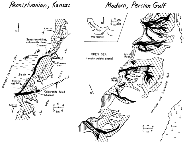
Baesemann, J.F., 1973, Missourian (Upper Pennsylvanian) conodonts of northeastern Kansas: Jour. Paleontology, v. 47, p. 689-710.
Brondos, M.D., 1978, Ph.D. dissertation in preparation: Univ. of Kansas.
Elias, M.K., 1937, Depth of deposition of the Big Blue (late Paleozoic) sediments in Kansas: Geol. Soc. America, Bull., v. 48, p. 403-432.
Ferm, J.C., 1970, Allegheny deltaic deposits: SEPM Spec. Pub. 15, p. 246-255.
Hakes, W.G., 1975, Trace fossil analysis of a transgressive sequence (Pennsylvanian, Kansas) (abs.): Am. Assoc. Petrol. Geol., Ann. Mtg. Dallas, Abstracts, v. 2, p. 32.
Harbaugh, J.W., 1959, Marine bank development in Plattsburg Limestone (Pennsylvanian), Neodesha-Fredonia area, Kansas: Kansas Geol. Survey, Bull. 134, pt. 8, p. 289-331. [available online]
Harbaugh, J.W., 1960, Petrology of marine bank limestones of Lansing Group (Pennsylvanian) southeast Kansas: Kansas Geol. Survey, Bull. 142, pt. 5, p. 189-234. [available online]
Harbaugh, J.W., 1962, Geologic guide to Pennsylvanian marine banks, southeast Kansas: Kansas Geol. Soc., 27th Field Conf. Guidebook, p. 13-67.
Harbuagh, J.W., and others, 1965, Field conference guide to Pennsylvanian marine banks, southeastern Kansas: Geol. Soc. America, Ann. Mtg., Kansas City, Field Conf. Guidebook, p. 1-46.
Heckel, P.H., 1972, Recognition of ancient shallow marine environments: SEPM, Spec. Publ. 16, p. 226-286.
Heckel, P.H., 1972a, Pennsylvanian stratigraphic reefs in Kansas, some modern comparisons and implications: Geol. Rundschau, v. 61, pt. 2, p. 584-598.
Heckel, P.H., 1975, Field guide to Stanton Formation (Upper Pennsylvanian) in southeastern Kansas: Kansas Geol. Society, 31st Field Conf. Guidebook, "Upper Pennsylvanian limestone facies in southeastern Kansas," p. 2-71.
Heckel, P.H. , 1975a, Stratigraphic and depositional framework of the Stanton Formation in southeastern Kansas: Kansas Geol. Survey, Bull. 210, 45 p. [available online]
Heckel, P.H., 1975b, Solenoporid red algae (Parachaetetes) from Upper Pennsylvanian rocks in Kansas: Jour. Paleontology, v. 49, p. 662-673.
Heckel, P.H., 1977, Origin of phosphatic black shale facies in Pennsylvanian cyclothems of Mid-Continent North America: Am. Assoc. Petrol. Geol., Bull., v. 61, p. 1045-1068.
Heckel, P.H. and Baesemann, J.F., 197S, Environmental interpretation of conodont distribution in Upper Pennsylvanian (Missourian) megacyclothems in eastern Kansas: Am. Assoc. Petrol. Geol., Bull., v. 59, p. 486-509.
Heckel., P.H. and Cocke, J.M., 1969, Phylloid algal-mound complexes in outcropping Upper Pennsylvanian rocks of Mid-continent: Am. Assoc. Petrol. Geol., Bull., v. 53, p. 1058-1074.
Moore, R.C., 1936, Stratigraphic classification of the Pennsylvanian rocks of Kansas: Kansas Geol. Survey, Bull. 22, 256 p.
Moore, R.C., 1949, Divisions of the Pennsylvanian System in Kansas: Kansas Geol. Survey, Bull. 83, 203 p. [available online]
Moore, R.C., 1950, Late Paleozoic cyclic sedimentation in central United States: 18th Internat. Geol. Cong., 1948, Great Britain, Rept., pt. 4, p. 5-16.
Moore, R.C., Elias, M.K., and Newell, N.D., 1936, A "Permian" flora from the Pennsylvanian rocks of Kansas: Jour. Geology, v. 44, p. 1-31.
Mossler, J.H., 1973, Carbonate facies of the Swope Limestone Formation (Upper Pennsylvanian) southeast Kansas: Kansas Geol. Survey, Bull. 206, pt. 1, p. 1-17. [available online]
Newell, N.D., 1933, The stratigraphy and paleontology of the upper part of the Missouri Series in eastern Kansas: Ph.D. dissert., Yale Univ., 247 p.
Russell, J.L., 1972, Depositional environment of the Rock Lake Shale (abst.): Geol. Soc. America, Abs. with Prog., v. 4, no. 4, p. 293.
Schroeder, R.A., and Hayes, J.B., 1968, Dickite and kaolinite in Pennsylvanian limestones of southeastern Kansas: Clays & Clay Minerals, v. 16, p. 41-49.
Senich, M.A., 1975, Relation of biotic assemblages to lithofacies in Stanton Limestone (Upper Pennsylvanian), southeastern Kansas: M.S. thesis, Univ. of Iowa, 198 p.
Senich, M.A., 1978, Macrofossil distribution in the Stanton Formation (Upper Pennsylvanian) in eastern Kansas: Ph.D. dissertation, Univ. of Iowa.
Wagner, H.C., 1954, Geology of the Fredonia Quadrangle, Kansas: U.S. Geol. Survey, Geol. Quad. Map 49.
Wagner, H.C., 1961, Geology of the Altoona Quadrangle, Kansas: U.S. Geol. Survey, Geol. Quad. Map 149.
Wanless, H.R., and others, 1970, Late Paleozoic deltas in the central and eastern United States: SEPM, Spec. Pub. 15, p. 215-245.
Weller, J.M., 1958, Cyclothems and larger sedimentary cycles of the Pennsylvanian: Jour. Geology, v. 66, p. 195-207.
Wilson, F.W., 1957, Barrier reefs of the Stanton formation (Missourian) in southeast Kansas: M.S. thesis, Kansas State Univ., 50 p.
Wilson, F.W., 1957, Barrier reefs of the Stanton formation (Missourian) in southeast Kansas: Kansas Acad. Sci., Trans., v. 60, no. 4, p. 429-436.
Wood, R.H., Jr., 1977, Conodont distribution in facies of the Stanton Formation (Upper Pennsylvanian, Missourian) in southeastern Kansas: M.S. thesis, Univ. of Iowa, 121 p.
Wood, R.H., Jr., and Heckel, P.H., 1977, Significance of conodont distribution in the Stanton cyclothem (Missourian, Upper Pennsylvanian) in eastern Kansas (abst.): Geol. Soc. America, Abs. with Prog., v. 9, p. 667-668.
Wray, J.S., 1964, Archaeolithophyllum, an abundant calcareous alga in limestones of the Lansing Group (Pennsylvanian), southeastern Kansas: Kansas Geol. Survey, Bull. 170, pt. 1, p. 1-13. [available online]
Zeller, D.E., ed., 1968, The stratigraphic succession in Kansas: Kansas Geol. Survey, Bull. 189, 81 p. [available online]
Carbonate lithologies consisting almost entirely of coarsely crystalline calcite spar are known from Upper Pennsylvanian phylloid algal mound complexes in the Iola, Plattsburg, Stanton and Oread Formations in southeastern Kansas (Heckel and Cocke, 1969). The thickest and most extensive known exposure of algal sparite is found in the middle of the Captain Creek Limestone Member of the Stanton Formation near the south end of the mound belt. Designated unit 6 at Stop 8 on this field trip, the algal sparite is the most conspicuous lithologic unit of the roadcut, forming massive vertical walls of largely buff to brown, coarsely crystalline, vuggy, unbedded rock approximately 6 m. thick. A number of rusty patches consisting of small crystal-lined voids are scattered throughout the unit. Except for an irregularly defined band about 0.5 m. thick near the middle, which contains large clast-like masses of calcilutite, unit 6 contains little obvious carbonate mud.
The massive sparite of unit 6 overlies a unit of sparry algal calcilutite (unit 5), which is more typical of Upper Pennsylvanian algal-mound lithologies in Kansas; the contact between these units is sharp, gently undulatory and stylolitic. Above the sparite with more gradational contact is 1 m. of bedded skeletal calcilutite (unit 7), and gradationally above unit 7 is 2.6 m. of massive sparry algal calcilutite (unit 8), which contains notably larger spar patches beneath algal blades than does unit 5. In terms of relative amounts of spar versus mud, unit 8 appears to be intermediate between the "typical" sparry algal calcilutite of unit 5 and the algal sparite of unit 6.
In hand specimen, both the algal sparite of unit 6 and the large patches of spar beneath algal blades in unit 8 consist of extremely large, dull brownish calcite crystals, which contain lighter, cloudy ghost structures visible mainly on polished, cut surfaces, or on large, apparently slightly curved cleavage surfaces. These cloudy ghost structures typically appear as 1) complex botryoidal forms with indistinctly concentric and radial fabric (seen under a hand lens) or, less commonly 2) smooth-surfaced geopetal fabrics. Scattered throughout the sparite of both units 6 and 8 are small elongate light-colored fragments that appear to be the micritized or mud-encrusted outer surfaces of algal blades (see Heckel and Cocke, 1969, Figs. 7, 9, 10). Often these are paired like railroad tracks with the former center of the blade now represented by either clear or cloudy spar.
The gross fabric of the sparite in unit 8, both in patches beneath large algal blades, with smooth bases over geopetal sediment (now skeletal calcilutite), and filling fractures transecting portions of the calcilutite, is that of spar merely filling larger voids than is usual. Evidence of extensive neomorphism of sediment is lacking. The gross fabric of unit 6 differs mainly in the presence of much less calcilutite, except in the zone through the middle. Nevertheless, even away from the middle, small patches of calcilutite are present, and these often display the curved shapes of algal blades below and smooth geopetal sedimentary surfaces above, which suggest origin by settling of small amounts of mud onto the algal blades. So far there is no definite evidence for neomorphism of significant original loose sediment in unit 6 either, although whether sufficient framework could have been supplied to the rock by the algal blades alone remains a valid question, which will be addressed later.
In thin section, the algal sparites of both units display a variety of microstructures. Thin sections taken from the ghost botryoidal structures show radiating lines of tiny inclusions, all within a single giant calcite crystal (Plate 1a). Often, the giant calcite crystals consist of strained sub-crystals with irregular sutured boundaries that sometimes follow a few of the lines of inclusions (Plate 1b). Outer boundaries of the radially structured features are often distinct enough to show a hemispherical to nearly spherical shape (Plate 1c). In places these boundaries mark merely the terminations of the radiating lines of inclusions entirely within the large calcite crystal, which is clearer beyond the terminations (Plate 1d). In other places, the boundaries mark the end of the large calcite crystal as well, which then often abuts against a finer, more typical blocky mosaic of calcite (Plate 1e). In most cases, the hemispherical cloudy areas with radial lines of inclusions appear originally to have been botryoidal growths of radiating acicular crystals emanating from a single point. In rare instances where they can be discerned clearly, individual crystal terminations are blunt and sometimes appear to have been broken (Plate 1f). High-magnification examination of some rays reveals that the dark material is arranged transverse to the ray direction, as though reflecting crystal growth zones. The botryoidal growth forms, acicular nature, and blunt terminations of the rays suggest that these features were originally crusts of aragonite, which were original partial void fillings that eventually became neomorphosed to the large strained calcite crystals. Although boundaries of the large strained crystals sometimes coincide with boundaries of the radial inclusion structures (Plate 1e), more frequently they do not (Plate 1d). This means that in some cases the large calcite crystals were entirely neomorphic and replaced only acicular botryoidal aragonite and were later encrusted by much smaller blocky unstrained calcite crystals in a later stage of void filling, whereas in other cases the large crystals did not stop forming at the boundaries of the aragonite, but grew on into space as void-filling spar.
Thin sections of the ghost geopetal fabrics show the geopetal feature to consist of similar tiny inclusions, which, however, are not aligned as in the botryoidal fabric. The position on top of algal blade fragments in the base of a void sheltered by a large algal fragment (Plate 1g) strongly suggests origin as an internal fine "dirty" sediment partially filling a small blade-sheltered void (within a larger void) and now incorporated entirely within a giant strained calcite crystal. Thus it would seem that these giant calcite crystals that could neomorphose botryoidal aragonite and fill remaining void space, could also neomorphose some internal sediment as well. This ghost neomorphosed internal sediment, however, was probably later than, and most likely somewhat chemically different from, the original mud sediment that is now calcilutite and does not appear to have been significantly affected by the giant strained calcite crystals.
Scattered throughout the sparite of unit 6 are small rusty patches, commonly voids lined with red-brown drusy crystals resembling dolomite. In thin section these crystals turn out to be calcite with strongly developed lines of iron-oxide that delineate forms similar to dolomite rhombs (Plate 1h). These lines do not follow the present irregular calcite crystal boundaries, and suggest an origin by calcitization of original ferroan dolomite, in which some of the iron had oxidized along cleavage planes. These calcitic rusty patches thus may be a recent weathering product of rust-colored dolomite patches like those observed in the Iola sparite lens seen at Stop 3, which may represent an even later stage of void filling in the sparite under further different chemical conditions.
Several of the sparite occurrences from other algal mound complexes have been examined briefly by the authors, or by others (J.C. Mitchell, D.L. Nelson, work in progress on Iola and Plattsburg respectively). Some form of relict radially aligned inclusion structures have been noted in each occurrence. The degree of "sparification," or amount and size of spar crystals in the rock varies, but the consistent appearance of radial inclusions in the spar suggests a genetic relationship, as if the development of botryoidal radial crystals facilitated recrystallization into large calcite spar crystals. Although other differences exist among individual sparite occurrences, it seems possible that each sparite can be placed in a rough developmental sequence, with spar growth having been arrested by alteration of the diagenetic environment at different stages. In the Captain Creek sparite, the "sparification" process appears to have proceeded further than in the other occurrences.
Recent studies of carbonate cement and recrystallization fabrics in both modern and ancient environments have helped to clarify the genesis of similar radial structures, which probably are analogous to those discerned in the Captain Creek sparite. Ginsburg and James (1976) described the development of botryoidal aragonite as early subsea cement in Holocene reef limestones off the coast of Belize. Comparison of their illustrations with relict botryoidal structure in the Captain Creek sparite reveals a striking similarity of general morphology. Mazzullo and Cys (1977) described and illustrated similar fabrics in Permian reef-associated rocks from the Guadalupe Mountains of Texas and New Mexico, and discussed their development from original rayed structures to small spar crystals with sutured boundaries and undulatory extinction patterns. Kendall (1977) coined the term "fascicular-optic calcite" for spar containing similar bundles of rayed inclusions and undulatory optical extinction, differentiating it from previously described "radiaxial calcite" (Kendall and Tucker, 1973) on the basis of optic axis patterns. Kendall (1977) also suggested that development of large individual spar crystals may be facilitated by pre-existing radial acicular crystal structures in which optical orientations of adjacent crystallites are nearly parallel.
Davies (1977) has distinguished two types of radiating structures preserved as relicts in calcite spar of Upper Paleozoic reef complexes from the Canadian Arctic. One type resulted from spar replacement of a void-filling, probably aragonitic hemispheroid, similar to the botryoidal aragonite described by Ginsburg and James (1976); Davies termed this type of spar "botryoidal calcite." The second type of spar is spherical to fan-shaped and occasionally replaces fossil grains, preserving ghostly outlines of the pre-existing structures. Davies (1977) termed spar of this kind "spherulitic calcite" and suggested that it grew originally as acicular aragonite neomorphic after mud sediment. Both types were~found commonly in association, and Davies theorized that both developed from similar geochemical circumstances, which are not yet understood.
Although the radial structures in the Captain Creek algal sparite seem likely to have developed in a similar manner to the modern botryoidal void-filling aragonite cement found by other workers, a question concerning the degree of original void space still remains. Phylloid algal blades, if sturdy enough, probably could have supported a great deal of original void space in the sediment. Even so, it seems unlikely that the algal blade fabric evident on outcrop and polished hand specimens could have achieved sufficient grain support for later void-filling development of all the spar now present, unless very early development of pervasive botryoidal aragonite cement actually augmented the algal blades in providing framework to the rock before much overburden could have caused collapse to a more grain-packed fabric. Thus although Davies, (1977) model provides a mechanism for development of large individual spar crystals in void space while, at the same time, eliminating mud (and possibly skeletal grains) by growth of neomorphic aragonite spherules later recrystallizing into calcite spar, it may not be necessary to explain the Captain Creek sparite. In any case, the development of botryoidal aragonite and subsequent recrystallization into large calcite crystals proceeded to an extreme stage where virtually all original void space, whether or not initially partly filled by botryoidal aragonite, and any later mud infiltrating the remaining voids, became engulfed in the giant strained calcite spar crystals. It is noteworthy that the same growing giant calcite crystals were both neomorphic after acicular spar as well as after mud, and void-filling of any remaining space.
It is also worthy of comment that Ginsburg and James (1976) found modern botryoidal aragonite along the seaward margins of the Belize reefs, Davies (1977) found botryoidal and spherulitic calcites in upper Paleozoic shelf-edge Canadian buildups, and Mazzullo and Cys (1977) found similar cements in the reef and upper fore-reef deposits of the Captain complex. Except for the thin lenticular Iola sparite (Stop 3), the best development of sparites in Kansas algal mounds are found near the carbonate-detrital facies belt boundary, along which at least some of the mounds appear to have faced a topographically lower detrital basin (see description of southern rim of Stanton mound tract in this guidebook). The diagenetic environment leading to formation of relict radially structured sparites is at present a subject of speculation, but it would seem that their common occurrence in organic buildups along the higher sides of topographic features is more than a coincidence.
Ginsburg, R.N., and James, N.P., 1976, Submarine botryoidal aragonite in Holocene reef limestones, Belize: Geology, v. 4, p. 431-436.
Heckel, P.H. and Cocke, J.M., 1969, Phylloid algal-mound complexes in outcropping Upper Pennsylvanian rocks of Mid-Continent: Am. Assoc. Petrol. Geol., Bull., v. 53, p. 1058-1074.
Kendall, A.C., 1977, Fascicular-optic calcite: a replacement of bundled acicular carbonate cements: Jour. Sed. Petrol., v. 47, p. 1056-1062.
Kendall, A.C., and Tucker, M.E., 1973, Radiaxial fibrous calcite: a replacement after acicular carbonate: Sedimentology, v. 20, p. 365-389.
Mazzullo, S.J., and Cys, J.M., 1977, Submarine cements in Permian boundstones and reef-associated rocks, Guadalupe Mountains, west Texas and southeastern New Mexico; in, Upper Guadalupian Facies, Permian Reef Complex, Guadalupe Mountains, New Mexico and West Texas, M.E. Hileman and S.J. Mazzullo, eds.: Permian Basin Sect., SEPM, p. 151-200.
Plate 1--Photomicrographs of algal sparite facies in Captain Creek Limestone at Stop 8. Scale bar in lower right is 0.05 m long unless otherwise indicated.
1a--Cloudy part of giant calcite crystal showing radiating lines of inclusions (center, right) and included subcrystals (left, extinct under crossed polarizers). Unit 6.
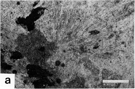
1b--Cloudy part of giant calcite crystal showing subcrystals with irregular boundaries, some following a few lines of inclusions (crossed polarizers). Unit 6.
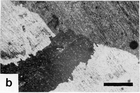
1c--Cloudy part of giant calcite crystal showing three ghost hemispherical shapes formed by radiating bundles of inclusions. Unit 6.
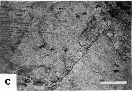
1d--Boundary of cloudy part within giant calcite crystal (below) containing radiating lines of inclusions, with clear part (above) beyond terminations of lines of inclusions. Unit 6.
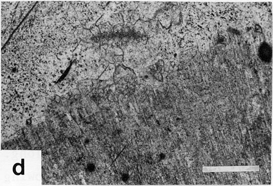
1e--Boundary of giant calcite crystal (above) that coincides with boundary of hemispherical shape, which abuts against finer more typical blocky calcite mosaic representing later stage of void filling. Unit 6.
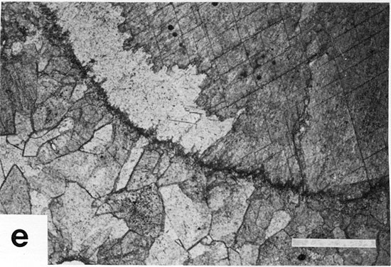
1f--Part of giant calcite crystal with ghost hemispherical shapes showing blunt terminations of former component acicular crystals suggesting that they were originally aragonite. Unit 6.
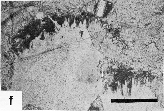
1g--Part of giant calcite crystal showing geopetal cloudy portion (darker) with small algal fragments in base of clear void (lighter) sheltered beneath larger algal blade (top left) and suggesting origin of cloudy area as "dirty" internal sediment. Scale bar is 2.0 mm long. Unit 8.
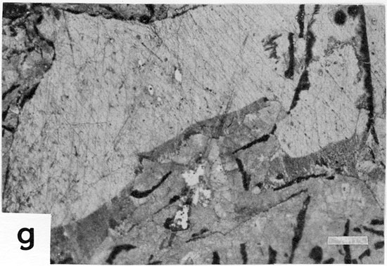
1h--Calcite crystals (shades of gray under crossed polarizers) that show strong rhombic lines of iron oxide, which are not coincident with calcite boundaries, but suggest origin along cleavage planes of ferroan dolomite that has subsequently been calcitized. Unit 6.
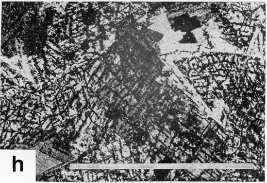
Plate 2--Photomicrographs of selected carbonate facies at Stops 1-4. Scale bar in lower right is 1.0 mm long unless otherwise indicated.
2a--Basal Raytown invertebrate calcarenite (crinoid stem along top) showing no evidence of grain abrasion, micrite envelopes or algal remains; darker grains are masses of encrusting foraminifers. Stop 1.
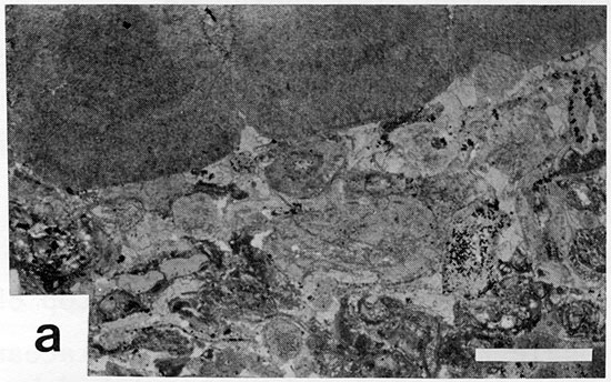
2b--Upper Bethany Falls oolite overlain abruptly by laminated siliceous crust that forms lower part of paleocaliche profile. Stop 2A.
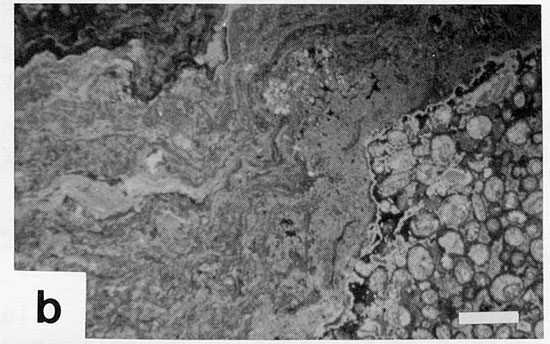
2c--Rubbly calcirudite forming upper part of paleocaliche profile at top of Bethany Falls, showing irregular layering around "clasts" that seem joined to one another. Stop 2A.
2d--Critzer spar-cemented, abraded-grain skeletal calcarenite with fragments of mollusks (clear) and dasyclad green alga, Epimastopora (darker grains with fencework structure). Stop 2B.
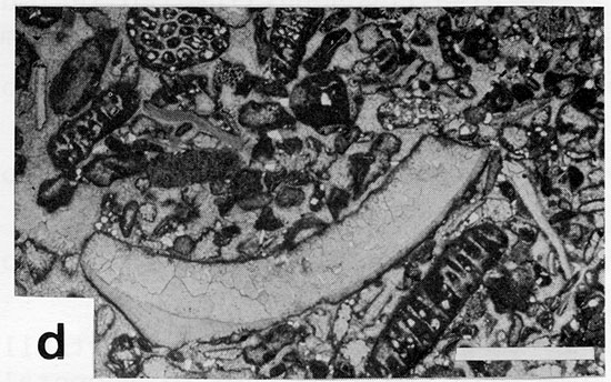
2e--Upper Sniabar skeletal calcarenite with scattered coated grains. Stop 2B.
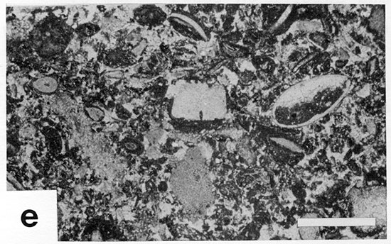
2f--Thin lens of calcilutite at top of Sniabar with ostracodes and foraminifers, probably representing lagoonal deposit. Stop 2B.
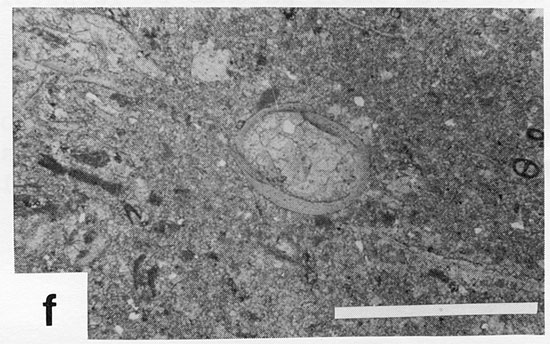
2g--Iola sparite showing geopetal dolomite structures (upper center: clear coarse crystals above slightly darker smaller crystals) in field of coarse calcite (gray), some showing ghost radial structure (right), and small patches of calcilutite (black). Stop 3.
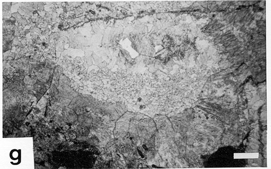
2h--Benedict bed oolite, with coated Punctospirifer shells, overlying stromatolite head. Scale bar is 2.0 mm long. Stop 4A.
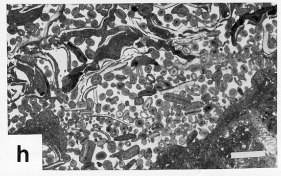
2i--Captain Creek mound facies showing mass of blue-green algal fi-laments encrusting clearer crystalline remains of phylloid algal blades. Stop 4A.
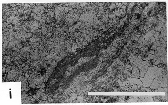
2j--Basal Stoner invertebrate calcarenite showing no evidence of grain abrasion or algal activity. Dark irregular lines around some grains is iron oxide stain. Stop 4B.
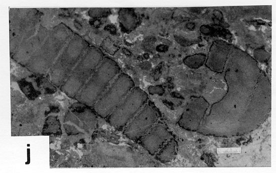
Plate 3--Photomicrographs of selected carbonate facies at Stops 5-10. Scale bar in lower right is 1.0 mm long unless otherwise indicated.
3a--Upper Stoner spar-cemented, abraded-grain skeletal calcarenite on northwestern rim of mound tract; many grains have thin micrite envelopes. Stop S.
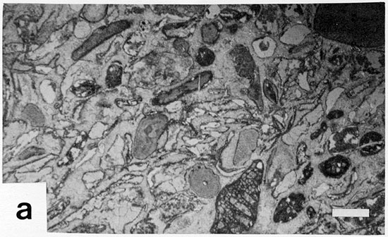
3b--Upper Stoner mound facies away from northwestern rim showing partly altered algal blades in somewhat muddy matrix. K39-US75 roadcut east of Stop 4B, for comparison to Plate 3a.
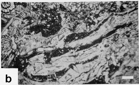
3c--Upper Stoner spar-cemented, abraded-grain skeletal calcarenite in axis of Wilson County channel; many grains have thin micrite envelopes. Stop 6B.
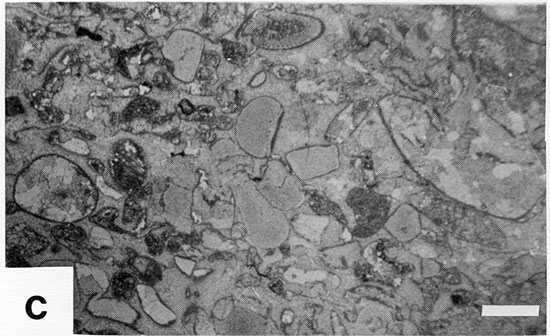
3d--Limestone lens (Benedict bed) in Vilas Shale with well preserved codiacean green alga Eugonophyllum (collected, thin sectioned and photographed by J.E. Barrick). Scale bar is 0.2 mm long. Stop 7.
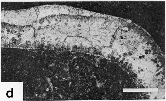
3e--Spring Hill mound facies, Unit 3, showing "spar spots" of spherulitic origin in microspar matrix. Stop 7.
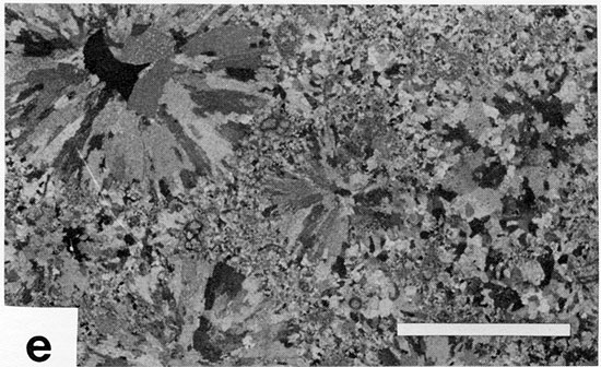
3f--Spring Hill mound facies, Unit 3, showing "spar spots" of obscure origin. Stop 7.
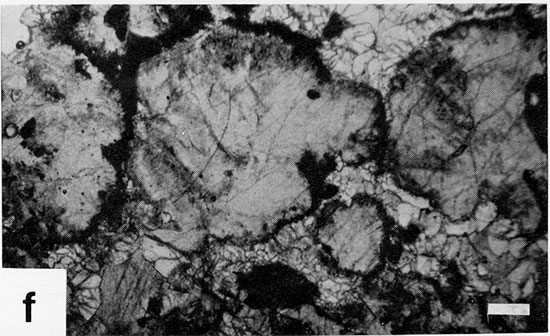
3g--Captain Creek mound facies with void sheltered by thin algal blade (lower left) offset by fracture in mud (along top); clear spar fills both fracture and sheltered void. Stop 8.
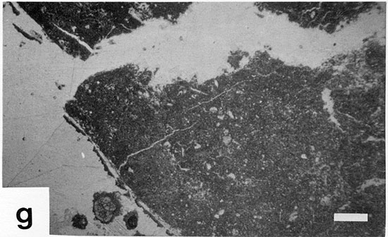
3h--Stoner mound facies, showing partially altered, partially dissolved algal blades, some with small patches of geopetal mud settled on tops. Stop 8.
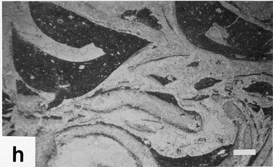
3i--Drum oolite, with neomorphosed ooids and oomolds, some partially filled with clearer crystals of calcite. Stop 9.
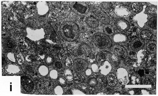
3j--Tyro oolite, showing spar-cemented ooids, several quartz-nucleated, with patchy fine-grained ferroan dolomite replacement of both spar and ooids (darker area in lower left center and granular-looking area in upper right).
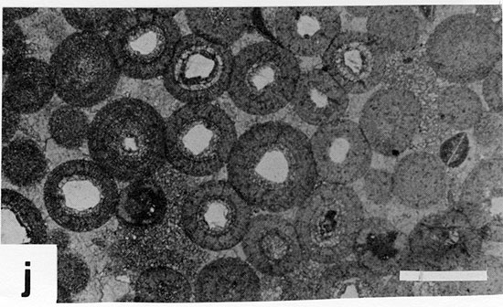
Kansas Geological Survey, Upper Pennsylvanian Cyclothemic Limestone Facies in Eastern Kansas
Placed on web July 6, 2009; originally published in Feb. 1978.
Comments to webadmin@kgs.ku.edu
The URL for this page is http://www.kgs.ku.edu/Publications/Bulletins/GB2/index.html