Kansas Geological Survey, Bulletin 197, originally published in 1969
Originally published in 1969 as Kansas Geological Survey Bulletin 197. This is, in general, the original text as published. The information has not been updated.
The Toronto limestone Member, at the base of the Oread Limestone (Pennsylvanian), averages about 10 feet in thickness. It is exposed in southeastern Nebraska and northwestern Missouri and can be traced across eastern Kansas, grading southward into shale in northern Oklahoma. A thin Osagia algal oncolite zone, which is the strand-line record of a transgressing sea, occurs at the base of the unit over much of northern and central Kansas. A 4- to 8-foot skeletal lime wackestone with an open-marine fauna covers the oncolite zone and extends into Oklahoma and Nebraska. This facies contains three subfacies which are products of local conditions during the inundative (standing-level) phase of a sea and not migrating facies tracts of a transgressing sea. From central Kansas northward a 1- to 4-foot lime mudstone with a molluscan fauna occurs at the top of the Member. This is a shallow subtidal to tidal-flat deposit accumulated during regression. The Toronto limestone facies do not fit into a phase scheme representing definite stages of transgression and regression. The stratigraphic relationships are similar to those in the Recent carbonate sequence of the Great Bahama Bank and suggest that a eustatic change in sea level was the controlling mechanism during the deposition of the Toronto Limestone.
Thin, sheet-like limestones enclosed in shales are the outstanding feature of the Pennsylvanian (Missourian and Virgilian) section exposed in Kansas and adjoining parts of Missouri, Nebraska, and Iowa. Some of these limestones can be traced with certainty for distances up to several hundred miles on the outcrop and can be correlated from the outcrop into the subsurface for similar distances (Moore, 1950, 1964; Morgan, 1951). This study is concerned with recognition of sedimentary facies and reconstruction of the depositional environment of the Toronto Limestone Member of the Oread Limestone, included in the Shawnee Group of Virgilian age. Because the Toronto Limestone is a marker unit in the subsurface, many petroleum geologists are interested in its depositional history. The principles applied in this study can also be applied in the search for facies changes in exploring for stratigraphically trapped oil.
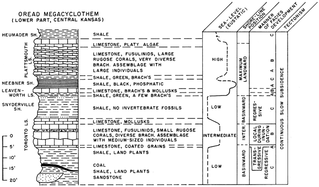
The Shawnee Group is said to contain the most complete record of so-called megacyclothems or cycles of cyclothems in the Upper Pennsylvanian of the Midcontinent (Moore, 1950, p. 11). The five limestones recognized by Moore, 1936, 1950) in the Oread megacyclothem are widespread and distinctive. The lower three limestones are characterized by lithologic types and faunas thought to be diagnostic of individual cyclothems (Fig. 1). Each cyclothem is viewed as being partly to completely developed and differing in composition from associated cyclothems. The lower limestone (Toronto) is about 5 to 15 feet thick, yellowish-brown, argillaceous, and irregularly bedded. The middle limestone (Leavenworth) is only 1 to 2 feet thick, bluish-gray, dense, and generally a single bed (Toomey, 1964). The upper or third limestone (Plattsmouth) is light-gray, wavy-bedded, and comparatively thick (10-30 feet). The fourth and fifth limestones (Kereford and Clay Creek) are less distinctive and probably continuous only from central Kansas northward.
Figure 1--Stratigraphic position of Oread Limestone and Oread megacyclothem. Section at left shows general relationship of Oread Limestone to other rock units [letters m, n, o, and p are four megacyclothems recognized by Moore (1950)]. Oread megacyclothem (O) on right [arabic numerals on far right refer to cyclothems recognized by Moore (1950) within Oread megacyclothem]. Stratigraphic concepts of Douglas Group after Ball (1964). Lansing and Shawnee interpretation after Jewett, O'Connor, and Zeller (1968).
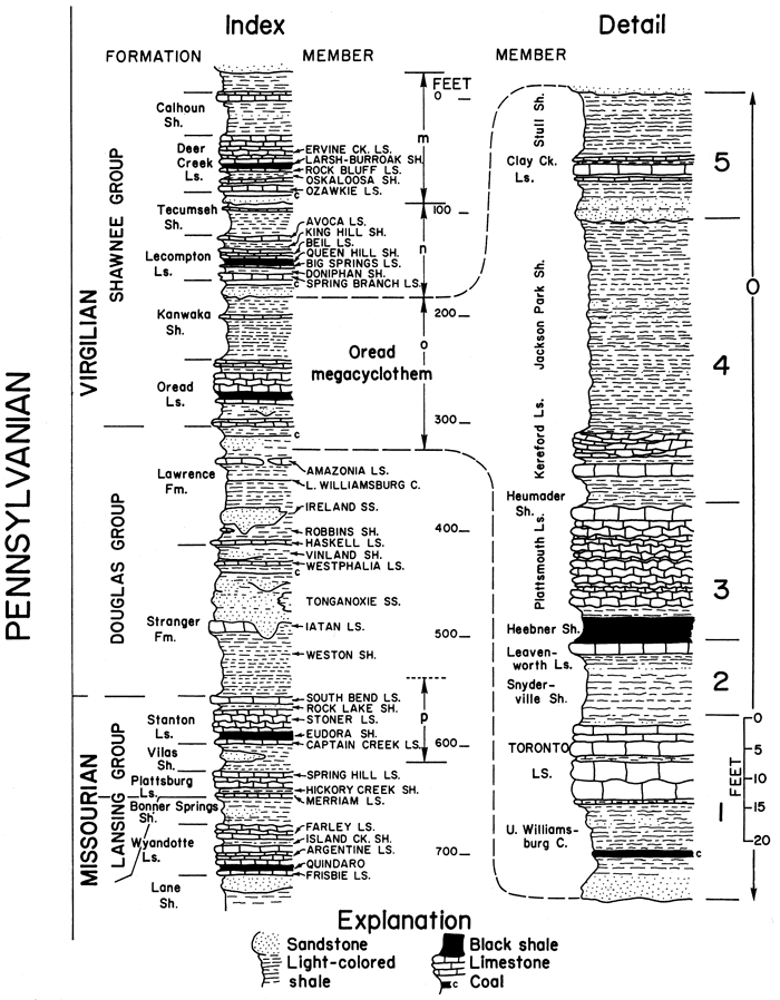
A diagnostic feature of the Oread megacyclothem is a black fissile shale (Heebner) in the third cyclothem (Moore, 1936; Evans, 1967). The lower (Toronto) cyclothem is termed complete because it contains an ascending succession of sandstone, shale, coal, and shale beneath it. The middle (Leavenworth) and upper (Plattsmouth) cyclothems both lack sandstones or coals and are, therefore, said to be "compressed" (Moore, 1936). Only through detailed stratigraphic and petrographic studies of the individual limestones can the validity of the megacyclothem concept be evaluated.
This report on the Toronto Limestone delineates the sedimentary facies and reconstructs the general depositional history of the limestone. The results of these studies suggest a eustatic change in sea level as the cause of the cycle.
I am grateful to E. G. Purdy, from whom I learned many of the principles of Recent carbonate deposition in British Honduras as a field assistant in 1961-62. I thank Carey Croneis, who served as chairman of the dissertation committee, and R. R. Lankford and T. E. Pulley, who were members of that committee. D. F. Toomey, Pan American Petroleum Corporation, suggested the study and aided in the field work and petrographic studies. Discussions with S. M. Ball, Pan American Petroleum Corporation, made me aware of many of the intriguing problems of Kansas geology, and he accompanied me to several key outcrops. J. K. Evans, Pan American Petroleum Corporation, gave field assistance and "brainstormed" many of the problems with me. G. A. Sanderson, Pan American Petroleum Corporation, identified the fusulinids, and K. J. Mesolella, of the same firm, suggested improvements in the manuscript. Encouragement and monetary support were provided by the State Geological Survey of Kansas through the efforts of D. F. Merriam. P. H. Heckel, of the Kansas Survey, read the manuscript and made helpful suggestions. The study was made possible through donation of some outcrop descriptions, rock samples, and thin sections by Shell Development Company. Special thanks are due J. M. Parks, formerly with the Shell Development Company, who initiated the work and encouraged me to continue the study. I am grateful to Mrs. Marthann David for editing the manuscript and to Mrs. Carol Erwin for typing, both of whose help made publication possible.
The Oread Limestone, basal formation of the Shawnee Group, contains seven members (Fig. 1). In spite of the seemingly monotonous alternations of shale and limestone bodies, each member of the Oread has distinct lithologic features. In areas where one member has undergone a facies change, the change can be detected by using the other members as key lithologic markers.
Figure 2 is a schematic cross section illustrating lateral continuity of some of the marine members of the Oread (i.e., Toronto Limestone, Leavenworth Limestone, Heebner Shale, and Plattsmouth Limestone) northeastward from Oklahoma into Kansas, Missouri, and Iowa. The Kereford Limestone Member of the Oread is confined to central and northern Kansas, Missouri, and Nebraska. Some of the more conspicuous lateral changes in the Oread are in the marginal-marine to continental Snyderville Shale section. The Snyderville increases in thickness toward southern Kansas and changes from bluish-gray and gray to green and red shale and becomes increasingly sandy toward the south. The Toronto, Leavenworth, and Plattsmouth limestones grade laterally into marginal-marine terrigenous clastics in Osage County, Oklahoma. The Leavenworth persists farther south than the Toronto. The black Heebner shale changes to bluish-gray shale bearing a diverse invertebrate fauna, and it thickens abruptly in Oklahoma (Evans, 1967). The Plattsmouth Limestone persists as a thicker body of carbonate farther south than does the Toronto Limestone, but it lenses out in a clastic section in extreme northern Oklahoma (Fig. 2). The clastic section, termed the "Vamoosa Formation," is equivalent to Douglas and Shawnee rocks and can be traced southward to the northern flanks of the Arbuckle Mountains (Oklahoma Geol. Survey & U.S. Geol. Survey, 1954; Ball, 1964).Figure 2--Restored cross section of Douglas Group and lower part of Shawnee Group. Datum is base of Toronto Limestone. Shawnee data from Moore, 1964; Cooley, 1952; Hershey, et al., 1960; Toomey, 1964; Evans, 1967; and Troell, 1965. Douglas reconstruction from Ball,1964.
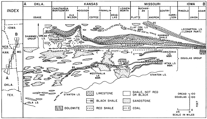
Except for the Heumader Shale and Kereford Limestone, members of the Oread Limestone are recognized also in Nebraska and Iowa where several features of the stratigraphy are noteworthy. Although the units from the Toronto through the Plattsmouth can be recognized in Nebraska, the shale intervals are thin. In fact, the shales have thinned so considerably that the lecompton Limestone (Fig. 1) lies only a few feet above the Oread. The "Weeping Water Limestone," as the Toronto is termed in Nebraska, is lithologically similar to outcrops of the Toronto in Missouri. In Adair County, Iowa, outcrops of the Leavenworth Limestone, Heebner Shale, and Plattsmouth Limestone are present, but a calcareous quartz sandstone is present in the stratigraphic position of the Toronto. The Snyderville Shale is relatively thick in Oklahoma, Kansas, and Nebraska, but thins into Iowa. This thinning is thought to be due to lack of a major source of terrigenous sediment and a slower rate of subsidence.
The Plattsmouth, Heebner, Leavenworth, Snyderville, and Toronto members of the Oread have been identified widely in the subsurface of Kansas as much as 300 miles west of the outcrop belt (Moore, 1950, p. 12-13; 1964, p. 333-334). The Heebner Shale is highly radioactive and, as a key bed, can be traced widely in the subsurface by use of gamma-ray logs (Moore, 1950, p. 13; Morgan, 1951, p. 3).
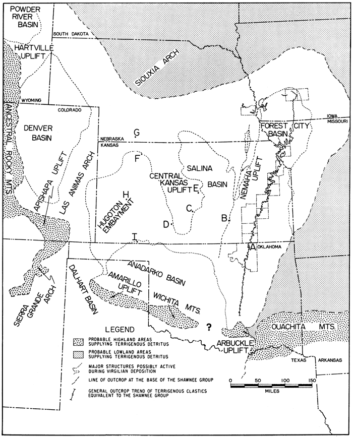
Figure 3 is a regional map showing the areal extent of Oread strata. The five members of the Oread Limestone listed above can be traced as far northwest as borehole F, as far west as borehole H, and as far southwest as borehole I (Moore, 1950, fig. 6, p. 14; Morgan, 1951, exhibit 3, p. 9). Moore notes that a single black shale unit is present in each of his subsurface sections at the position of the Heebner except in a southwestern Kansas well where another radioactive (black) shale occurs, presumably a few feet higher in the section (borehole 1, Fig. 3).
Figure 3--Majot peleotectonic features in Kansas and surrounding states during Virgilian time [modified from Tectonic Map of the United States, Am. Assoc. Petrol. Geol., 1944, and state geologic maps of Oklahoma (1954), Kansas (1964), Missouri (1939), Nebraska (1950), and Iowa (1937)]. Letters indicate boreholes to which subsurface correlations of Oread Limestone have been made.
Lukert (1949) published two cross sections revealing some Oread stratigraphic relationships. One section extends from southern Osage County, Oklahoma, westward to northeastern Garfield County. This cross section (ibid., pl. 2) shows that the Plattsmouth Limestone, Heebner Shale, and Leavenworth Limestone can be traced in the subsurface at least one and possibly two townships farther to the east in Oklahoma than can the Toronto Limestone.
Results of both outcrop and subsurface studies of the Oread show wide lateral continuity for the Toronto, Leavenworth, and Plattsmouth limestones and the Heebner Shale, but the Toronto Limestone is not as widespread as the other members.
Regional stratigraphic analysis of the Shawnee Group (Rascoe, 1962) suggests that the early Virgilian sea entered the Anadarko basin and the Kansas shelf from the Dalhart basin area of the Texas Panhandle (Fig. 3). According to Rascoe (1962, p. 1364-1365) more than two-thirds of the Shawnee Group (Topeka, Deer Creek, Lecompton, and Oread) in southwestern Kansas is composed of carbonates which extend into the mouth of the Dalhart basin. Toward the Apishapa-Sierra Grande uplift, the carbonates change to interbedded limestones and shales and then, bordering the uplift, into arkosic clastics. Some of the arkosic sediments flanking the Amarillo-Wichita uplift are assumed to be coeval with the Shawnee Group. Adkison (1963) describes the Heebner Shale as black and the other Oread shales as gray. He recognized crinoids, brachiopods, and fusulinids in the Oread limestones in the subsurface of south-central Kansas, which would indicate a shelf environment of deposition for these limestones. Adkison stated that the Oread (and indeed the entire Shawnee Group) is principally limestone, which suggests slowly subsiding and possibly shoaling conditions in the area of the Central Kansas uplift (Fig. 3). The Shawnee Group shelf limestones of Kansas grade into silty gray shales interspersed with thin limestones and sandstones in the Anadarko basin. The Oread Limestone, however, is widely distributed over the basin (Rascoe, 1962, p. 1365).
Both Shaw (1964) and Irwin (1965) drew distinctions between oceanic, coastal deposition (marginal) and nonoceanic, epicontinental (epeiric) deposition. Marginal seas inundate only the periphery of the continents today, whereas epeiric seas spread inland for many hundreds of miles during the Pennsylvanian Period. Principal differences between the two settings are the extreme shallowness, wide areal extent, and low bottom slopes in epeiric seas. These geographic relationships acted to restrict water circulation and are thought to have reduced wave action and diurnal tides.
The widespread Toronto Limestone was deposited in an epeiric sea extending at least 450 miles--from the Dalhart basin to southwestern Iowa. The outcropping portion of the Toronto represents sedimentation in a basin margin setting (Fig. 3).
The term "sedimentary facies" is used here to indicate gross fabric type (Dunham, 1962) and constituent composition of a rock (limestone) sequence which records different depositional environments.
Detailed studies of Toronto Limestone exposures (Fig. 4) revealed key lithologic types, gross rock types, and stratigraphic relationships. Fossils were collected at outcrop localities (Table 1), and the limestone beds were sampled to obtain specimens for thin sections. About 500 thin sections were examined; 140 of these were point-counted. These thin-section data were subjected to a factor analysis by means of a computer, and the results were integrated with data from the other thin sections, field observations, and analyses of shales.
Figure 4--Location map of Toronto exposures and cores studied. Solid line connecting the localities denotes reconstructed section (Fig. 6). List of localities in Table 1.
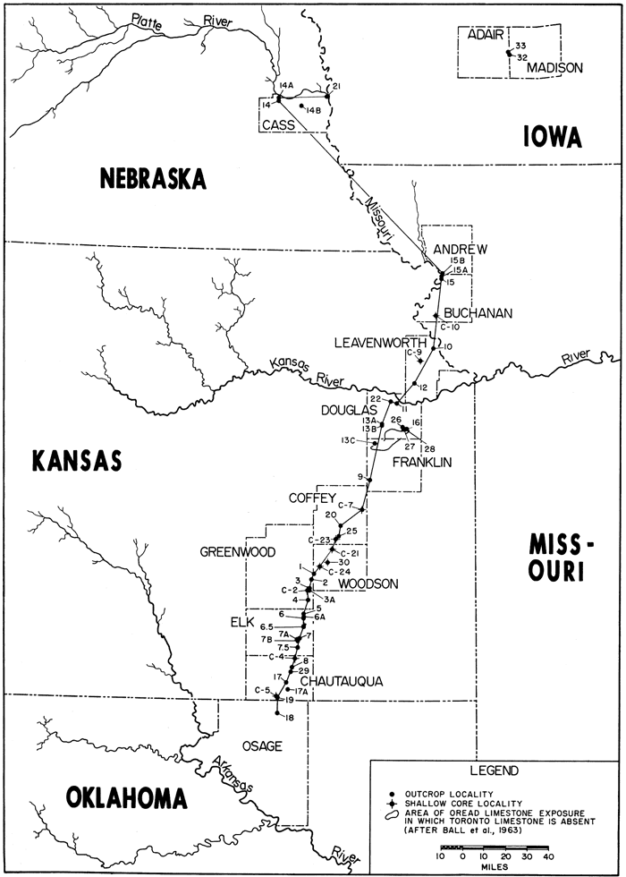
Table 1--List of localities. C=core localities; remainder are outcrop localities. Numbers given in order from south to north along cross-section list in Figure 4.
| 18. | NW NE sec. 7, T 28 N, R 10 E, Osage County, Oklahoma. Exposure in bar ditch at corner in county road about 5 miles south of state line. |
| 19. | SW NE sec. 12, T 35 S, R 10 E, Chautauqua County, Kansas. Exposure in road gutter near base of hill 1.5 miles northeast of Elgin. |
| C-5. | NW NE sec. 12, T 35 S, R 10 E, Chautauqua County, Kansas. Shallow core drilled west of road. |
| 17A. | NW SW sec. 23, T 34 S, R 11 E, Chautauqua County, Kansas. Exposure of Plattsmouth Limestone, Heebner Shale, Leavenworth Limestone, and Snyderville shale in road cut on north side of hill. No Toronto Limestone present. |
| 17. | NE NW sec. 4, T 34 S, R 11 E, Chautauqua County, Kansas. Exposure in road ditch at corner along county road. |
| 29. | NE sec. 12, T 33 S, R 11 E, Chautauqua County, Kansas. Exposure on hillside along east side of county road, beneath massive sandstones. |
| 8. | CEL sec. 36, T 32 S, R 11 E, Chautauqua County, Kansas. Kansas. In ditch on left side of road atop small hill immediately south of larger hill capped by Plattsmouth Limestone. |
| C-4. | SE NW sec. 8, T 32 S, R 12 E, Chautauqua County, Kansas. Shallow core locality. |
| 7.5. | SW sec. 16, T 13 S, R 12 E, Elk County, Kansas. Exposure in road ditch on east side of county road on north slope of hill, 1.5 mile south of Longton. |
| 7B. | C NW sec. 33, T 30 S, R 12 E, Elk County, Kansas. Near junction of a creek and north-trending tributary of same. |
| 7A. | C sec. 33, T 30 S, R 12 E, Elk County, Kansas. Road cut on east-west road, 1 mile northwest of Longton. |
| 7. | NE SW sec. 27, T 30 S, R 12 E, Elk County, Kansas. Exposure in bar ditch on west side of county road, about 1 mile north of Longton. |
| 6.5. | E line SE NW sec. 6, T 30 S, R 12 E, Elk County, Kansas. Exposure in cutbank of stream, 100 yards west of road. |
| 6. | NW NE sec. 12, T 29 S, R 12 E, Elk County, Kansas. Exposure in road cut at intersection of two county roads. |
| 6A. | SE SE sec. 1, T 28 S, R 12 E, Elk County, Kansas. Exposure in road cut on south side of east-west trending road. |
| 5. | S.L. NE sec. 36, T 28 S, R 12 E, Elk County, Kansas. Exposures in bar ditch at break in slope along east-west road and in trench silo a few yards south of road. |
| 4. | CSL sec. 29, T 27 S, R 13 E, Greenwood County, Kansas. Exposure in bar ditch near base of hill on east-west road. |
| C-2. | NW SW sec. 5, T 27 S, R 13 E, Greenwood County, Kansas. Shallow core locality. |
| 3A. | SW NW sec. 4, T 27 S, R 13 E, Greenwood County, Kansas. Exposure in cutbank of stream on Hibbard's farm. |
| 3. | CSL SW sec. 33, T 26 S, R 13 E, Greenwood County, Kansas. Exposure along stream adjacent to county road. |
| 1. | CNL NW sec. 35, T 25 S, R 13 E, Woodson County, Kansas. Exposures in road cut along U.S. Highway 54 and in quarry about 200 yards due south of road cut; Toronto type locality. |
| C-24. | CSL sec. 8, T 25 S, R 14 E, Woodson County, Kansas. Shallow core locality. |
| 30. | S.L. sec. 35 and 36, T 24 S, R 14 E, Woodson County, Kansas. Outcrop study. |
| C-21. | SW SE sec. 31, T 31 S, R 15 E, Woodson County, Kansas. Shallow core locality. |
| C-23. | CN2 SW sec. 4, T 23 S, R 15 E, Coffey County, Kansas. Shallow core locality. |
| 25. | CL secs. 34 and 35, T 22 S, R 15 E,. Coffey County, Kansas. Road cut on U.S. Highway 75, 0.5 mile south of Gridley turnoff. |
| 20. | C SE sec. 2, T 22 S, R 15 E, Coffey County, Kansas. Exposure in small quarry about 200 yards north of east-west county road. |
| C-7. | CSL sec. 32, T 20 S, R 17 E, Coffey County, Kansas. Shallow core locality. |
| 9. | W2 sec. 24, T 18 S, R 17 E, Franklin County, Kansas. Exposures on west side of U.S. Highway 50 on either side of intersection with county road. |
| 13C. | WL NW sec. 32, T 15 S, R 18 E, Franklin County, Kansas. Road cut on county road just south of intersection. |
| 13B. | SW C SE sec. 14, T 14 S, R 18 E, Douglas County, Kansas. Road cut on east-west road on east side of due south extension of Lone Star Lake. 13A. NW sec. 14, T 14 S, R 18 E, Douglas County, Kansas. Exposure above and west of dam at Lone Star Lake and along road south of dam site. |
| 26. | NW sec. 28, T 14 S, R 20 E, Douglas County, Kansas. Exposure in quarry adjacent to county road. |
| 27. | SWC NW sec. 27, T 14 S, R 20 E, Douglas County, Kansas. Exposure in quarry several hundred yards west of curve on county road. |
| 28. | Same location as L-27. Exposure is road cut on county road at curve at north edge of hill. |
| 16. | SW NE sec. 27, T 14 S, R 20 E, Douglas County, Kansas. Exposure in ditch along road on north slope of hill. |
| 22. | C NW sec. 21, T 12 S, R 19 E, Douglas County, Kansas. Exposure in road cut along interstate 70, just east of county road overpass outside city of Lawrence. |
| 11. | NW sec. 36, T 12 S, R 19 E, Douglas County, Kansas. Exposure in city of Lawrence at road cut northwest of University of Kansas campus. |
| 12. | CSL NW sec. 8, T 11 S, R 21 E, Leavenworth County, Kansas. Exposure in road cut along State Highway 16, 1 mile west of Tonganoxie. |
| C-9. | CNL sec. 26, T 9 S, R 21 E, Leavenworth County, Kansas. Shallow core locality. |
| 10. | NW NW sec. 22, T 8 S, R 22 E, Leavenworth County, Kansas. Exposure in road cut atop hill on State Highway 7. Leavenworth type locality. |
| C-10. | C S line sec. 22, T 55 N, R 37 W, Buchanan County, Missouri. Shallow core locality. |
| 15. | NE NW sec. 31, T 58 N, R 35 W, Buchanan County, Missouri. Exposure in bluff above abandoned Huemader's Quarry. |
| 15A. | NW margin sec. 30, T 58 N, R 35 W, Buchanan County, Missouri. Exposure in bluff adjacent to Missouri River near Andrew County line. |
| 15B. | SW sec. 19, T 58 N, R 35 W, Andrew County, Missouri. Exposure in stream cut along Andrew-Buchanan County line, just south of road. |
| 14B. | C N line sec. 5, T 10 N, R 12 E, Cass County, Nebraska. Exposure in road cut on west side of Cedar Creek, 1.7 miles east of Weeping Water. |
| 14. | NW sec. 15, T 12 N, R 10 E, Cass County, Nebraska. Quarry on Pawnee Creek, about 0.5 south of confluence of Pawnee Creek and Platte River. Exposure of Cass Limestone, Lawrence Shale, Toronto Limestone, Snyderville Shale, Leavenworth Limestone, Heebner Shale, and lower part of Plattsmouth Limestone. Cretaceous conglomerate directly on Plattsmouth. |
| 14A. | SW NW sec. 15, T 12 N, R 10 E, Cass County, Nebraska. Exposure in Johansen's Quarry on Pawnee Creek, west of South Bend. |
| 21. | Central portion sec. 6, T 12 N, R 14 E, Cass County, Nebraska. Exposure along railroad tracks northeast of Plattsmouth. |
| 33. | NE NE sec. 1, T 75 N, R 30 W, Adair County Iowa. Exposure in valley walls of small tributary of Middle River. |
| 32. | SW NW sec. 7, T 75 N, R 29 W, Madison County. Iowa. Small outcrop adjacent to road bridge on south side of east-west-trending stream. |
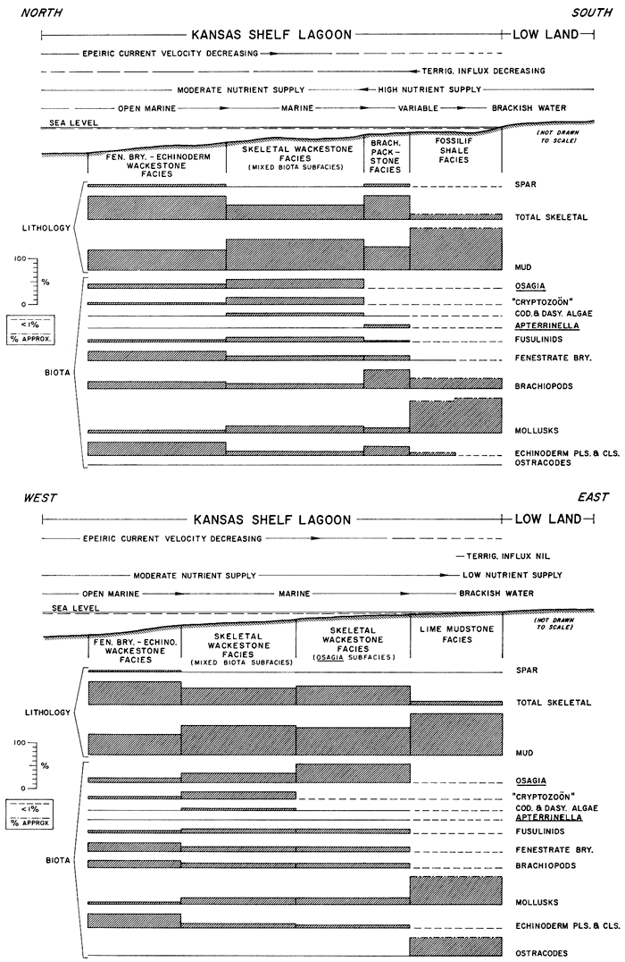
Five facies and five subfacies are recognized in the Toronto cyclothem: (1) skeletal wackestone (with mixed biota, molluscan, and Osagia subfacies); (2) brachiopod facies (with brachiopod packstone and brachiopod marl subfacies); (3) fenestrate bryozoan-echinoderm wackestone facies; (4) Osagia grainstone facies; and (5) lime mudstone facies. A sixth facies, fossiliferous shale, is transitional with the Toronto Limestone. These facies are enclosed by unfossiliferous shale of probable brackish-water or nonmarine origin. Constituent compositions of the Toronto cyclothem facies are tabulated in Table 2 and plotted in Figure 5.
Figure 5--Histograms showing rock and biotic composition of five facies and five subfacies in Toronto Limestone Member. Biota percentages recalculated on basis of 10 most abundant skeletal types. Histograms at left show composition in terms of mud (MU), spar (SP), and skeletal grains (SK). Histograms on right illustrate composition of skeletal grains in terms of 10 biotic constituents. PA=platy algae; TU=Tubiphytes; Oa=Osagia; Cy="Cryptozoon"; AP=Apterrinella; FB=fenestrate bryozoans; BS=brachiopod shells; Mo=mollusks, EF=echinoderm fragments--mainly crinoids; and Os=ostracodes.
A, Osagia grainstone facies; B, Brachiopod packstone subfacies: C, Fenestrate bryozoan-echinoderm wackestone facies; E, Skeletal wackestone facies, mixed biota subfacies; F, Skeletal wackestone facies, molluscan subfacies; G, Lime mudstone facies.
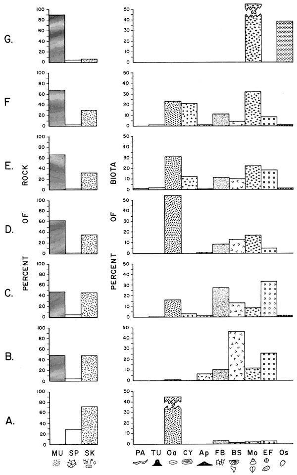
Table 2--Volutiietric composition of Toronto Limestone facies. (Mean values.
| Brachiopod packstone subfacies n=8 |
Fenestrate bryozoan- echinoderm wackestone facies n=32 |
Osagia grainstone facies n=2 |
Skeletal wackestone facies |
Lime mudstone facies n=11 |
|||
|---|---|---|---|---|---|---|---|
| Mixed biota wackestone n=55 |
Molluscan wackestone n=19 |
Osagia wackestone n=6 |
|||||
| Percent of skeletal grains, recalculated to 100 percent | |||||||
| Epimastopora | 0 | <1 | 0 | .2 | 0 | 0 | 0 |
| Platy algae | 0 | <1 | 0 | .5 | 0 | 0 | 0 |
| Tubiphytes | 0 | .2 | 0 | 1.3 | .5 | 0 | 0 |
| Osagia | .5 | 18.2 | 86.1 | 19.8 | 15.0 | 36.9 | 0 |
| Algal mat | 0 | 0 | 0 | 2.5 | 0 | 0 | 0 |
| "Cryptozoon" | 0 | 2.1 | 0 | 7.5 | 14.7 | 0 | 0 |
| Apterrinella | 4.6 | .2 | 0 | .4 | .3 | .5 | 0 |
| Fusulinids | 1.7 | 3.4 | 0 | 9.6 | 6.2 | 8.4 | 0 |
| Other foraminifers | 1.6 | .2 | .1 | .8 | .9 | .5 | 0 |
| Fenestrate bryozoans | 7.5 | 19.1 | 2.5 | 6.8 | 7.1 | 6.1 | 0 |
| Ramose bryozoans | .6 | .4 | 0 | .2 | 1.6 | 0 | 0 |
| Encrusting bryozoans | .4 | .9 | 0 | .2 | .8 | 0 | 0 |
| Brachiopod shells | 35.1 | .6 | .5 | 6.6 | 2.7 | 8.1 | 0 |
| Brachiopod spines | 4.3 | .8 | .1 | .4 | .1 | 1.2 | 0 |
| Mollusks | 8.3 | 5.7 | 2.1 | 14.4 | 20.6 | 12.6 | 19.2 |
| Echinoderm pls. and cls. | 18.7 | 23.8 | 3.1 | 6.3 | 5.0 | 4.5 | 7.5 |
| Echinoid spines | .4 | .3 | 0 | .2 | .1 | .2 | 0 |
| Trilobites | .2 | .3 | 0 | .1 | 0 | 0 | 7.5 |
| Ostracodes | .5 | .3 | 0 | .1 | .4 | .2 | 13.2 |
| Unknown skeletal | 15.9 | 21.9 | 5.4 | 21.4 | 23.7 | 21.0 | 63.8 |
| Percent of rock | |||||||
| Total skeletal | 46.1 | 47.1 | 73.2 | 33.3 | 30.3 | 35.7 | 2.7 |
| Lime mud | 47.8 | 48.2 | 0 | 65.7 | 67.8 | 61.7 | 90.6 |
| Calcite spar | 4.1 | 4.6 | 26.5 | 1.2 | 1.6 | 1.4 | 2.2 |
| Intraclasts | .1 | 1 | .3 | <.1 | <.1 | .4 | .5 |
| Terrigenous silt | .1 | <.1 | 0 | .4 | <.1 | <.1 | .9 |
Figure 6 is a schematic cross section showing distribution of the facies of the Toronto and contiguous strata. The datum is a shaly or marly zone which is less than one foot thick. This horizon is recognized from Elk to Leavenworth counties, Kansas, and is thought to be correlative with a shaly bed in Nebraska. Encrusting bryozoan oncolites and horn corals are common in this interval in the Elk-Coffee County region of Kansas.
Figure 6--Restored cross section of Toronto Limestone Member and contiguous strata showing distribution of facies and subfacies at localities shown in Figure 4. A larger version of this figure is available.
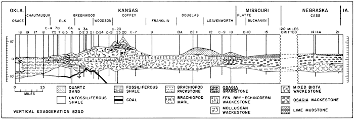
Most of the Toronto Limestone from southern Kansas to southeastern Nebraska (Table 2; Fig. 6) is a skeletal wackestone with a varied but fragmented biota. This facies can be divided into three subfacies on the basis of biotic composition: (1) mixed biota subfacies, (2) Osagia subfacies, and (3) molluscan subfacies.
Approximately the lower half of the Toronto from southern to northeastern Kansas is a light-gray (fresh) to buff or brown (weathered), thin- to thick-bedded limestone. This interval--the mixed biota subfacies--yields a diverse biota (Fig. 8, E). Osagia oncolites, mollusks, fusulinids, "Cryptozoon" oncolites (Fig. 7, D), fenestrate bryozoans, brachiopod shells, and crinoid parts are each present in amounts ranging volumetrically from 5 to 20 percent of the biota (Table 2). Seventeen genera of brachiopods are recognized in this subfacies (Troell, 1965). Four genera of mollusks, three of pelecypods, one of gastropods, and two of sponges can be identified. Corals, including solitary lophophyllids and a colonial tabulate (Syringopora), are consistent components, but are not abundant.
At the base of the mixed biota subfacies at Localities 20, 9, 13A, 22, 11, and 12 (Fig. 6) is a shelly zone consisting primarily of Osagiacoated skeletal grains, fusulinids, and small brachiopods (Fig. 8, G). This interval, which is only a few inches thick, is a marker bed that is much more fossiliferous than the rest of the mixed biota subfacies. The rock types of this shelly zone are in the wackestone to packstone class. The mud matrix contains terrigenous silt. The Osagia oncolites are small bean-shaped, coated grains. As observed in thin section, they have a shell-fragment nucleus and are coated by thin, crinkly, concentric, dark calcareous laminae. Encrusting foraminifers commonly are found within the dark calcite laminae, and sinuous Girvanella tubes, produced by boring, frequently occur in the colony. Shell debris and quartz silt also are bound into the oncolites. The nuclei of these coated grains commonly have been bored. These characteristics are seen in oncolites in modern seas (Ginsburg, 1960).
The skeletal wackestone facies contains more Osagia oncolites (Fig. 8, F) in northwestern Missouri and southeastern Nebraska than it does in central Kansas (Fig. 5, 6). This abundance is emphasized by recognition of the Osagia subfacies in this region (Table 2). Fusulinids, fenestrate bryozoans, brachiopod shells, mollusks, and echinoderm parts each contribute between 5 and 10 percent to the biota of this subfacies and Osagia oncolites make up almost 40 percent.
Faunal diversity is lower in the Osagia subfacies than in the mixed biota subfacies. Epimastopora, Tubiphytes, and platy algae (Eugonophyllum), which are found in minor amounts in the mixed biota subfacies, are lacking in the Osagia subfacies. Only seven brachiopod genera are present in the Osagia subfacies compared to 17 in the mixed biota subfacies. No corals were identified from the Osagia subfacies. Most of the mollusks in the Osagia subfacies are Osagia-coated and were tabulated as Osagia, hence the percentage of mollusks appears to be lower than it actually is.
In central and southern Kansas between Localities 9 and 6.5 (Fig. 6) the upper Toronto contains several rock types, but the most abundant and persistent is a wackestone (Fig. 7, B, D) with abundant mollusks, "Cryptozoon" oncolites, and Osagia oncolites. This is the molluscan subfacies of the skeletal wackestone facies. Thirteen genera of brachiopods, two pelecypod genera, several gastropods, and lophophyllid corals were identified in this subfacies.
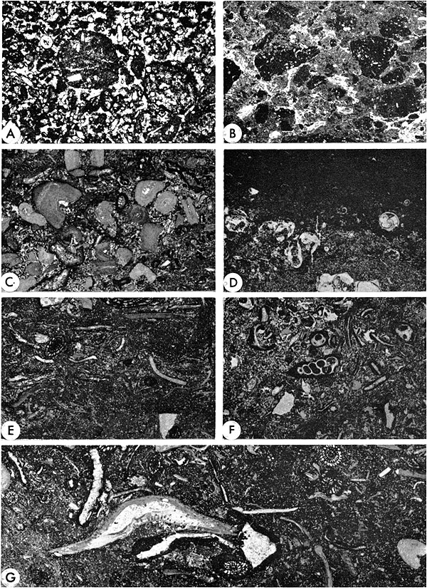
Figure 7--Representative photomicrographs of Toronto Limestone Member. All photographs in plane light in true vertical orientation. [Please note: images enlarged slightly and magnifications recalculated for web version to show more information.] A, Brachiopod facies, packstone subfacies. Thick shells near bottom are sedentary pelecypod Myalina. Overlying Myalina are flattened brachiopod shells, crinoid segments, rhomboporid bryozoans and brachiopod spines. Myalina found only near southern limit of brachiopod facies. Locality 18. x4.4. B, Skeletal wackestone facies, molluscan subfacies. Calcite-replaced gastropod on right. Fragment of Eugonophyllum (green codiacian alga) below and slightly left of gastropod. Other grains are crinoid parts, mollusk fragments, and fusulinids. Swirled pattern at top is due to burrowing organisms. Bioclastic nature of particles suggests slow depositional rate. Locality 3. x4.4. C, Organic mat. Tubiphytes Maslov in growth position inside large cavity. Innermost lamina (dark layer), above cavity, is composed of thread-like filaments similar to those in some red algae. Thicker layers are pelletal micrite and sparry calcite overlain by darker thin red algal layer. Growth of Tubiphytes inside cavity suggests that the organism may not be a green alga, but a hydrozoan, as suggested by Newell, et al., (1953, p. 112). Presence of encrusting bryozoans, fenestrate bryozoans, encrusting foraminifer Tetrataxis, and Tubiphytes on or within the mat suggests a subtidal depositional environment. Locality 1, mixed biota subfacies. x4.4. D, "Cryptozoon" oncolite. Specimen consists of alternating red? algal layers and sparry calcite with encrusting bryozoans, fenestrate bryozoans, encrusting foraminifer Tuberitina, and probable hydrozoan Tubiphytes intercalated into colony. Hemispherical shape of specimen surrounded by and infilled with mud is evidence of growth on muddy bottom. Rotation during growth is indicated by overturned laminae at bottom continuous with upper part of colony which is in growth position. Toronto "Cryptozoon" appears to have formed in a shallow, subtidal environment. This oncolite type is commonly referred to as "Ottonosia Twenhofel" but more closely resembles Cryptozoon kansasensis Johnson (see Johnson, 1963, p. 70 and 198). (Term "Cryptozoon" is in quotation marks to signify usage in a descriptive sense and to avoid confusion with Cryptozoon Hall, a blue-green algal stromatolite). Locality 1, molluscan subfacies of skeletal wackestone facies. "Cryptozoon" is thought to have formed in a shallow subtidal environment. Locality 1, molluscan subfacies. x4.4.
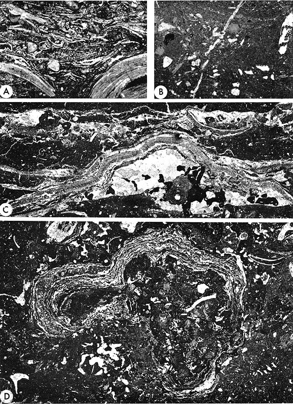
Figure 8--Representative photomicrographs of Toronto Limestone Member. Plane light in true vertical orientation. [Please note: images enlarged slightly and magnifications recalculated for web version to show more information.] A, Pelletoidal grainstone with lime wackestone intraclast, winnowed zone within lime mudstone facies. Locality 11. x11. B, Ostracode lime mudstone intraclasts with lime mud matrix: lime mudstone facies. Origin of pebbles explained by subaerial exposure of ostracode lime mud indurated by dessication, followed by reworking of mud cracks on a tidal flat by flooding. Similar lithologic types occur on modern supratidal flats in the Bahamas (Roehl, 1967). Locality 26. x4.4. C, Fenestrate bryozoan echinoderm facies. Both fenestrate bryozoans and echinoderm segments are present. x5. D, Lime mudstone facies over skeletal wackestone facies. Grains are ostracode valves and gastropod shells. Locality 14. x4.4. E, Skeletal wackestone facies, mixed biota subfacies. Brachiopod and pelecypod shell fragments, fenestrate bryozoans, and fusulinids. Skeletal grains grade with decreasing size into mud, suggesting that mud was formed by comminution of skeletal material. Locality C-7. x4.4. F, Skeletal wackestone facies, Osagia subfacies. Molluscan remains coated with detrital carbonate mud constitute Osagia oncolites. Locality 14A. x4.4. G, Skeletal wackestone facies. Basal detrital zone of Toronto Limestone Member at Locality 11. Larger shell is the brachiopod Neochonetes, above which is fragment of brachiopod Derbyia. Also present are fenestrate bryozoans, fusulinids, and crinoid parts. Dark coatings on grains are Osagia, a blue-green algal encrustation. Speckled appearance of matrix due to quartz silt. Brachiopods named above, fusulinids, Osagia coatings, and quartz silt characterize this lithologic marker zone. x5.5. [An illustration of the Toronto Osagia grainstone facies from Locality 20 is shown by Dunham in his classification of limestones (1962, p. 118, pl. 6, fig. C).]
The skeletal wackestone facies of the Toronto is underlain by a brachiopod facies in Nebraska and grades laterally into a brachiopod facies (Fig. 7, A) in southern Kansas.
In southern Kansas (Loc. 6.5, Fig. 6), the Toronto Limestone is a brachiopod packstone that changes to a shale facies southward. Brachiopod shells and spines account for 40 percent of the biota. Echinoderms (19 percent), mollusks, and fenestrate bryozoans (each 8 percent) are the only other abundant remains. Eight brachiopod genera are present. A conspicuous component in this subfacies is the encrusting foraminifer Apterrinella, which comprises 3 percent of the biota and occurs attached to brachiopod shells. The following mollusks were observed: the small, elongate burrowing pelecypod Nuculana, the pelecypod "Aviculopecten," and specimens of the gastropod Euphemites. Large, disarticulated valves of the sedentary, attached pelecypod Myalina (Orthomyalina) are found in the Toronto Limestone at its southernmost occurrence (Loc. 18, Fig. 6).
In Nebraska (Loc. 14, 14A, 21, Fig. 6), the lower Toronto is a shelly, fossiliferous limy shale or marl. This brachiopod mart subfacies rests disconformably on unfossiliferous red shales of the Lawrence Formation (Fig. 1), but grades upward into the overlying skeletal wackestone facies. Fossils in this subfacies are well preserved and include 10 genera of brachiopods, crinoid parts, fenestrate and ramose bryozoans, lophophyllid corals, and fusulinids.
This facies extends from southern Kansas to northwestern Missouri. It is generally a burrowed wackestone with almost 50 percent skeletal grains (Table 2; Fig. 5). Echinoderm fragments, fenestrate bryozoans, Osagia oncolites, and brachiopods, in that order, are the most abundant grain types (Fig. 8, C). Of lesser abundance are mollusks, "Cryptozoon" oncolites, and fusulinids. Fossils collected from this facies include eight genera of brachiopods and lophophyllid corals.
This facies is developed locally in northern Woodson and southern Coffee counties, Kansas. Almost 90 percent of the grains have Osagia coatings (Table 2; Fig. 5). Other conspicuous components are echinoderm plates, fenestrate bryozoans, and mollusks. Large, vertically oriented burrows with pelecypods (Wilkingia, previously called Allorisma) in a living position have been observed in this facies. Generally, the limestones of this facies are grain-supported and cemented with sparry calcite.
At northern Kansas and Nebraska outcrops, a lime mudstone facies is developed at the top of the Toronto Limestone (Fig. 8, D). Only 3 percent of skeletal grains occur within this facies (Table 2). Fossils observed include sponge spicules, ostracodes, several gastropod genera, and eight pelecypod genera, the most notable of which is Myalina. Intraclastic conglomerates have been found locally within the facies (Fig. 8, B). In Douglas County, Kansas (Loc. 22, Fig. 6), pelletoidal grainstones occur (Fig. 8, A).
At Localities 11 and 22 (Douglas County, Kansas), the contact between the lime mudstone facies and the underlying fenestrate bryozoan-echinoderm wackestone facies is irregular, wavy, and sharp. Bedding within the mudstone facies at these localities is thin, irregular, and discontinuous.
The fossiliferous shale facies is present mainly in southern Kansas and northern Oklahoma, but also occurs in northern Kansas and Missouri (Fig. 6). It is characterized by rapid lateral variation in fauna and lithologic character. In southern Kansas, green shales above a thin coal deposit are interbedded with limestone beds of the Toronto. Progressive lateral replacement of limestone beds by green fossiliferous shale in a southerly direction is indicative of facies change from limestone to fine clastics. Rapid faunal change and lithologic variation are seen in the fossiliferous shale beneath the Toronto Limestone. In Chautauqua County, these shales contain about six genera of brachiopods, several gastropod genera, burrowing pelecypods (including Nucula and Nuculana), crinoid columnals, and bryozoans. Several discontinuous horizons with abundant Myalina occur in the shales at some outcrop localities. Fusulinids are abundant in the limestone tongues of the Toronto and in the shales just beneath them in Elk County. At least seven genera of brachiopods, crinoid columnals, echinoid spines, lophophyllid corals, bryozoans, gastropods, and pelecypods (including scattered myalinids) are associated with the fusulinids. At Localities 6.5 and 7 (Fig. 6), a Myalina-rich shale overlies a blue-gray shale above the coal; fusulinids are extremely abundant in the shale above the Myalina shale. At Locality 5, fusulinid-rich shale and unfossiliferous shale overlie a blue-gray shale sequence capped by an oxidized horizon; coal is present beneath the blue-gray shale. In Greenwood County, at least five genera of brachiopods, crinoid parts, lophophyllid corals, fusulinids, and gastropods occur in the shale above the coal. In places (as at Locality 6A in Elk County), current-rippled sandstones and sandy shales bearing Nuculana, Myalina, and plant fragments are intercalated into the section.
The shale subjacent to the Toronto Limestone in northern Kansas and Missouri contains six genera of brachiopods, crinoid parts, bryozoans, and pelecypods, including Myalina.
This facies includes gray, green, and red shales. It is developed above (Snyderville Shale Member) and below (top of Lawrence Formation) the Toronto Limestone Member (Fig. 6). Generally, these shales lack invertebrate fossils, but locally they contain plant fragments and charophyte oogonia.
Facies changes in the Toronto Limestone to marine, brackish-water, and continental shales from southern Kansas to northern Oklahoma suggest that most contemporaneous clastics were derived from land areas in southern Oklahoma, Arkansas, and the southwestern portion of the Ozark dome. This source is indicated not only by the lithologic changes and the thickening of the Snyderville Shale section to the south (Fig. 2), but by directional features in the partially equivalent Vamoosa Formation in northern Oklahoma. Hicks (1962) has shown that cross-stratification readings in sandstone channels of the Vamoosa suggest prevailing westward and southwestward movement in northern Osage County, Oklahoma, but a northwestward trend is evident in northern Creek and southern Osage counties, Oklahoma. Thus, a depocenter for terrigenous influx presumably lay in the west-central portion of Osage County or farther west (Fig. 11). A delta or deltaic complex probably existed in western Osage County during deposition of the Toronto Limestone, and perhaps a shift in the distributary pattern allowed carbonate deposition to encroach into northern Oklahoma for short periods of time. Oklahoma exposures of the clastic sequence equivalent to the Toronto Limestone are thought to be the upper reaches or subaerial topset plain of a delta. This is based upon the convergence of channels in Osage County, the association of unfossiliferous red and green shales with the channels, and the absence of coals, which, if present, would suggest interdistributary marsh environments (Fisk, 1960).
Some of the channel bottoms in the Lawrence-Snyderville section in Osage County contain marine fossils such as brachiopods and bryozoans. These occurrences are best explained by invasions of dense marine waters along channel bottoms. This is caused by less dense, low-salinity water flowing over saline water of greater density. In northern British Honduras, saltwater has been observed as far as 50 miles upstream in the New River during the dry season (Pusey, 1964, p. 36); the occurrence of red mangroves at least 50 miles upstream in the Rio Hondo River of British Honduras indicates that saltwater penetration is not short-lived. I have seen thriving marine benthonic faunas near river mouths in southern British Honduras where bottom salinities are marine (30‰), but surface waters are brackish (10-15‰).
The relationship of the marine shale beds, laterally equivalent to the Toronto Limestone, within the Vamoosa delta in northern Oklahoma (Fig. 11) is interpreted as being similar to modern Atchafalaya Bay and surrounding environments situated immediately between the Chenier Plain and the birdfoot delta of the Mississippi River. Little sand reaches the Bay because coarse sediments are trapped in the Atchafalaya delta in Grand Lake about 50 miles inland (Fisk, 1956, p. 6). Silt and clay are discharged into Atchafalaya Bay and are swept by longshore currents westward as far as the Sabine River. The brackish-water to marine shale facies in the Toronto cyclothem is interpreted as having been deposited in a nearshore embayment somewhat similar to Atchafalaya Bay and bordering a deltaic complex possibly similar to, but on a lesser scale than, the modern birdfoot delta of the Mississippi River.
The fossiliferous shale facies is the most variable of all the Toronto facies in terms of biota. Fusulinid-rich shales occur near lenticular edges of limestone facies, and brachiopods (Neochonetes, Crurythyris, Linoproductus, Derbyia, and Antiquatonia), crinoids, and bryozoans are common in the shales farther removed from the limestone tongues. Shale beds containing abundant myalinids are commonly intercalculated with the brachiopod shales. Lack of a diverse fauna in the myalinid concentration suggests brackish-water conditions, and, considering the sessile habit of this pelecypod, a niche analogous to that of the modern bay oyster of the Gulf Coast (Crassostrea virginica) is envisaged. Brachiopods, bryozoans, and crinoids lived adjacent to the gregarious myalinid populations on a bottom, which in areas, or at times, was subjected to normal-marine waters. Whether the salinity differentiation was due to a bathymetric barrier to saline waters, circulation pattern, or climatic fluctuation is open to question. The situation may have been analogous to the fluctuation in salinity during alternating several-year-long periods of drought and normal rainfall in bays along the upper Texas Gulf Coast. During normal years, the salinity of the bays is low (brackish-water) and the macrofauna is almost exclusively molluscan, but during periods of extended drought the salinity of the lower parts of the bays may approach the values of the open Gulf and allow Gulf organisms, including small corals, to invade these areas (T. E. Pulley, personal communication, 1961).
In essence, quiet-water deposition is the general picture for the fossiliferous shale facies of the Toronto, as indicated by the presence of mud and the well-preserved, unworn condition of the fossils. Brackish waters are indicated by the accumulations of great numbers of myalinids, and normal-marine conditions are evidenced by the brachiopods, fusulinids, crinoids, corals, and bryozoans. The lenticular development of the variable-salinity faunal assemblages indicates a complex facies pattern, such as is found in deltaic environments in the modern Gulf of Mexico (Donaldson, 1966; Lankford and Shepard, 1960). A bay with variable salinity adjacent to a delta complex is suggested as the environment of deposition for these beds.
Limestone facies of the Toronto cyclothem were deposited in areas where the rate of clastic influx was negligible and clear water (Irwin, 1965) or autochthonous (Shaw, 1964) sediments could dominate.
The brachiopod facies at either end of the Toronto outcrop are proximal to marine shale (Fig. 6). The association of the brachiopod facies with marine shales is thought to be a consequence of increased nutrient supply in areas marginal to greater terrigenous influx. Emery and Stevenson (1957, p. 693) relate high concentrations of nutrients in modern estuaries and lagoons to nearness to land where runoff provides a continuous supply of nutrient-rich waters.
The brachiopod facies with its fusulinids, bryozoans, and crinoids accumulated below wave base under shallow-marine, subtidal conditions seaward of areas where marine shales were deposited. Algae may have been largely excluded from the brachiopod facies because of the high turbidity. Recognition of the pelecypod Myalina only in the southernmost exposure of the facies suggests proximity to brackish water to the south , inasmuch as Myalina apparently occupied a niche and had a habit similar to that of the modern brackish-water bay oyster Crassostrea virginica that is abundant in the low-salinity bays of the Texas Gulf Coast. Presence of angular and rounded lithoclasts of calcilutite and worn fusulinids in a packstone calcarenite at the top of the brachiopod facies at Locality 7 (Fig. 4) is evidence of early subaerial exposure. The brachiopod marl of Nebraska is a subtidal open-marine accumulation whose well-preserved shells suggest lack of scavenging organisms in a low energy environment.
The Osagia-rich zone is at the base of the mixed biota subfacies where brackish-water shales (with linguloid brachiopods and "Aviculopecten" pelecypods) or nonmarine (unfossiliferous) shales occur beneath the limestone. This zone was deposited at the strand line as marine waters of the Toronto sea transgressed (Fig. 13).
The bulk of the mixed biota subfacies is the record of deposition in open-marine, clear, intermittently agitated water with little terrigenous influx. This is indicated by the varied biota, including fusulinids, solitary and colonial corals, fenestrate and encrusting bryozoans, numerous brachiopods, and crinoid debris. This diverse fauna suggests optimum ecologic conditions, such as normal salinity and good water circulation, with abundant food supply.
Organic crusts or mats bearing some resemblance to modern algal mats were seen at three localities (Loc. 6A, 1, 22, Fig. 4) in the mixed biota subfacies (Fig. 7, C). The mats in the Toronto are made up of alternating thick micrite layers and thin red algal layers. The mats are lenticular, several inches thick, and only a few feet in length. Penecontemporaneous buckling of the laminae is indicated (Fig. 7, C) by a tubular encrusting organism, Tubiphytes Maslov, which is apparently in growth position attached to the roof of the cavities. The mats resemble blue-green algal mats common on the tidal flats of Florida Bay and the Bahamas (Ginsburg and Lowenstam, 1958; Monty, 1967). However, Ginsburg and Lowenstam (1958) report that in Florida Bay, algal mats may occur as much as 6 feet below the low-tide level. Monty (1967) reports that algal mats occur at depths up to 10 feet in the Bahamas. The spotty distribution of Toronto algal mats is taken to indicate shallow, subtidal conditions. Many of the skeletal grains are broken and have Osagia coatings on them. The predominantly clastic texture of the skeletal grains suggests a slow depositional rate relative to biological activity (scavenging, burrowing, encrusting, etc.), and the Osagia coatings suggest some bottom agitation.
Although the presence of lime mud in the mixed biota subfacies seemingly argues against bottom agitation, it is possible that much of the lime mud was formed at the bottom through skeletal disintegration and decomposition. Gradation in particle size from sand and coarser-sized skeletal grains to mud-sized carbonate suggests that much of the lime mud in the Toronto Limestone was produced by breakdown of skeletal material. Feeding activity by predators and scavengers, bacterial attack on organic material in shell structure, and boring activity by sponges and green and blue-green algae could have produced the mud. Carbonate muds in British Honduras are thought to have originated largely from skeletal disintegration through bacterial decay and abrasion (Purdy, 1963; Pusey, 1964; Matthews, 1966). Thus the percentage of carbonate mud in the Toronto may not be an accurate index to relative current strength. It is known that fine sediments are less readily eroded than coarser material after deposition (Hjulström, 1939). In addition to small grain-size, it is likely that the carbonate muds contained mucilagenous organic matter that would have further impeded bottom erosion.
The depositional environment of the Osagia subfacies seems to have been more restricted and the bottom more agitated than in the mixed-biota environment. This is indicated by fewer brachiopod genera and lack of corals. Clear water is indicated by the Osagia oncolites, considered to be of blue-green algal origin. The differences between the mixed biota and Osagia subfacies indicate perhaps that salinities, circulation, or food supply was not optimum in the northern part of the skeletal mud facies. Recent Molluscan biofacies patterns in Florida Bay are determined by relative variations in salinity (Turney, 1964); thus, salinity variation in the Toronto sea is a plausible explanation for the restricted fauna in the Osagia subfacies.
The high percentage of lime mud in the molluscan facies indicates a quiet to intermittently agitated depositional environment for most of this subfacies. Conditions were apparently open-marine, as indicated by corals, bryozoans, brachiopods, and echinoderms. Very shallow water near the southern limit of this subfacies is evidenced by fusulinid grainstones with scour-and-fill cross-bedding at Locality 6A (Fig. 4). In summary, clear, well-lighted, open-marine waters are suggested for the skeletal wackestone facies.
All three subfacies of the skeletal wackestone facies contain 15-37 percent Osagia oncolites (biota means). The coatings were developed by trapping and binding of fine carbonate and quartz silt. The only organisms in modern seas that trap and bind in this manner are blue-green algae, and an analogy between the Pennsylvanian and Recent forms seems reasonable. Ginsburg (1964, p. 22) states that modern blue-green algae may extend to depths of 120 feet in Recent seas, and algal scums are present to depths of 100 feet. Many of the Osagia nuclei have been bored, apparently by algae. Bathurst (1967, p. 459) reports that boring algae are not found living below 150 feet in modern seas. The common occurrence of Osagia oncolites in the skeletal wackestone facies suggests environmental conditions near the optimum, where light intensity was high. This seems to indicate that the Osagia grains formed in the upper part of the photic range for blue-green algae and in depths as great as perhaps 50 feet. It is also in agreement with the 0- to 40-foot depth-range found by Purdy (1963) for the skeletal mud facies in the Great Bahama Bank.
The presence of echinoderms, bryozoans, corals, fusulinids, and brachiopods in the fenestrate bryozoan-echinoderm wackestone facies is indicative of open-marine waters. The dominance of filter-feeding organisms in this facies implies a slow rate of sedimentation. The fragmented condition of the skeletal grains indicates the rate of sedimentation did not exceed the rate of burrowing and scavenging by deposit feeders. Osagia-coated grains are common in the facies and are suggestive of relatively clear, well-lighted, and at least periodically, agitated conditions.
Fusulinids in the fenestrate bryozoan-echinoderm facies are subcylindrical and may have been symbiotic with the crinoids. The streamlined nature of the test seemingly could have withstood considerable water turbulence. These fusulinids (Kansanella) contrast with robust forms (Triticites) that occur in the mixed biota and Osagia subfacies.
Suspension-feeding bryozoans, crinoids, and solitary corals are more abundant in the fenestrate bryozoan-echinoderm wackestone facies than in the other Toronto facies. These organisms suggest relatively clear, open-marine waters with an abundant supply of suspended food. Thus it appears that of all the Toronto facies, the fenestrate bryozoan-echinoderm facies was deposited in areas closest to open-marine circulation. Considering depth of deposition, the ubiquitous Osagia oncolites in this facies suggest depth of deposition on the order of the skeletal wackestone facies, approximated to be up to 50 feet or so. Although the algae may be an index to maximum depth, they imply little as to minimum depth. In the case of the fenestrate bryozoan-echinoderm facies, as well as for the major portion of the skeletal mud facies, water depths had to be sufficient for marine conditions to be maintained by circulation, so that average depths approaching 30-50 feet appear reasonable.
The Osagia grainstone facies accumulated in clear but agitated waters as suggested by the abraded condition of the Osagia nuclei, presence of the Osagia coatings, and lack of mud in intergranular areas. The diverse skeletal nature of the nuclei of the coated grains suggests open-marine conditions. Algal "biscuits" occur in a bed above the Osagia grainstone (Fig. 9, 4, B; Fig. 10). They are practically identical in size, shape, and microstructure to Recent forms from southern Florida and the Bahamas (Ginsburg, 1960) and Alacran Reef, Yucatan (Fig. 9, C, D). Ginsburg and Lowenstam (1958, p. 312) report algal biscuits in less than 10 feet of water in Florida and the Bahamas. The Osagia facies is viewed as a shoal-water deposit with the offshoal muddy sediments containing algal biscuits accumulating in water depths on the order of less than 20 feet. The depth figure is based on analogy with modern occurrences in Florida and the Bahamas.
Figure 9--Algal "biscuits" from Toronto Limestone and modern lagoon. [Please note: images enlarged slightly and magnifications recalculated for web version to show more information.] A, top view of algal biscuit; B, underside of algal biscuit; both from Toronto Limestone Member (Loc. 20, Fig. 4). C and D, top and bottom vews respectively of Recent algal biscuits from lagoon behind Alacran Reef on Campeche Bank, Yucatan (collected by Walter C. Pusey, III, from subtidal lagoon in less than 20 feet of water). Umbilical openings on undersides of both Toronto and Recent specimens indicate that biscuits originated by encrusting laminae that were deposited on projections above the bottom. Ginsburg (1960) reports identical blue-green algal biscuits from Florida and the Bahamas in marine subtidal waters less than 10 feet deep. All photos x 2.
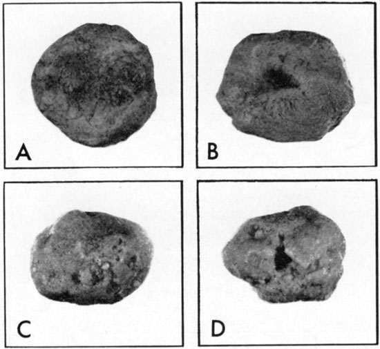
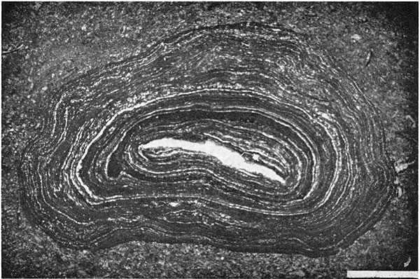
Figure 10--Photomicrograph of algal "biscuit" from Toronto Limestone Member (Loc. 20, Fig. 4). Cross-polarized light. Dark laminations are mud-sized sediment. Light laminations are sparry calcite, presumably having replaced blue-green algal laminae. Nucleus is shell. Contrary to biscuits shown in Figure 9, this biscuit his undergone repeated overturning, indicated by concentric laminations. Bar at bottom represents 2 mm.
The dominance of a molluscan fauna indicates restricted depositional conditions for the lime mudstone facies. The pelecypod Myalina is not abundant, but is widespread and suggests brackish water. The presence of mud-pebble beds and winnowed calcarenite zones is evidence for at least periodic subaerial exposure and occasional high kinetic energy that are typical in the supra- and intertidal zones of the Bahamas (Roehl, 1967; Shinn, Ginsburg, and Lloyd, 1965) and northern British Honduras (Ebanks, 1967). The remainder of the facies is similar to the shallow, nearshore, brackish-water ostracode-lime mud facies of northern British Honduras (Pusey, 1964).
Deposition of the Toronto Limestone began following a period of regression and emergence after deposition of the Amazonia Limestone Member of the Lawrence Formation and perhaps part of the shale above it (Fig. 1, 2). Widespread unfossiliferous red shale and bluish-gray silty shales bearing plant fragments, charophyte oogonia, and smooth-shelled ostracodes indicate nonmarine to brackish-water deposition just prior to Toronto sedimentation. The coal and shale beneath the Toronto Limestone represent marshland deposition similar to the peat formation in the Chenier Plain of Louisiana (Gould and Morgan, 1962, p. 292-326). The marshland probably formed to the north of a relatively large deltaic complex (Fig. 11).
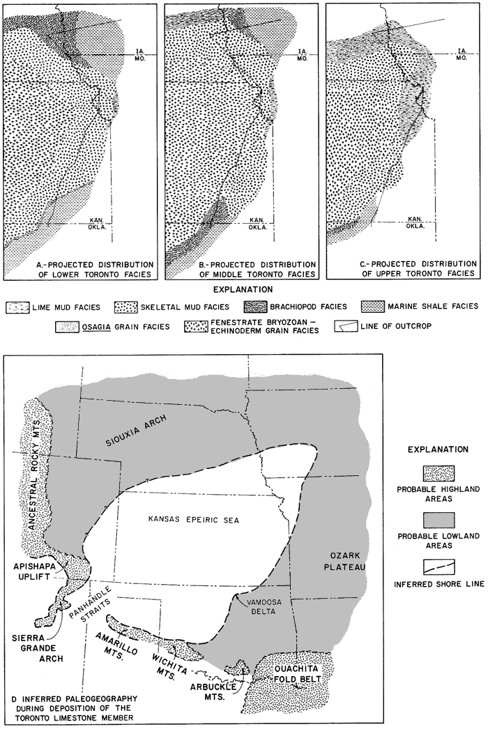
Figure 11--Inferred facies patterns after transgression of Toronto sea (A-C) (Fig. 13), and general paleogeographic setting during phase of inundation (D).
Lime deposition began with a rapid marine transgression. Rapidity is indicated by the general absence of a thick marine clastic interval at the base of the Toronto over most of central Kansas; the thin Osagia oncolite zone at the base of the section probably represents intertidal deposition. Where clastic deposition was able to keep pace with rising sea level, as in southern Kansas, the Toronto Limestone grades into marine and brackish-water shales and sandstones, which are of deltaic origin.
Environmental factors directly influencing the Toronto facies included: (1) the rate of detrital influx; (2) salinity that is related to circulation within the basin; (3) nutrient element supply; and (4) water agitation, which is related to bathymetry and hydrography.
Figure 12 is a reconstruction of the environment during the inundative phase of Toronto sedimentation. The wide distribution and thicker accumulation of the Osagia and mixed biota subfacies and the fenestrate bryozoan-echinoderm facies point toward deposition during maximum extent of the marine waters. The upper half of Figure 12 depicts the sea-to-land facies transition envisaged for southern Kansas and northern Oklahoma. Decreasing salinity and increase in terrigenous influx toward the land are thought to have given rise to the purely skeletal composition of the Toronto Limestone and the change to shale. Similar seaward (marine) to landward (brackish-water) changes can be seen today in the sediments in northern British Honduras (Pusey, 1964), in which skeletal grains (green algae, foraminifers, and mollusks) predominate. This pattern contrasts markedly with sediments seen in a seaward (marine) to landward (hypersaline) traverse in the Bahamas (Purdy, 1963), where nonskeletal grains (oolites, pellets, and grapestones) are most abundant. The lower half of Figure 12 is a reconstruction of facies relationships in northern Kansas where influx of terrigenous detritus was lacking. It was in these areas that Osagia oncolites and tidal-flat sediments became prominent.
Figure 12--Model of reconstructed facies patterns and mean constituent particle composition for the Toronto cyclothem. Upper diagram, from Vamoosa delta in northern Oklahoma due north to central Kansas (Fig. 11). Lower diagram, from northern Kansas eastward into northwestern Missouri.
Lack of widespread regressive facies (lime mudstone, Osagia grainstone, and molluscan subfacies) at the top of the Toronto Limestone is suggestive of nondeposition or erosion. Although there is some evidence of erosion locally at the top of the Toronto, indications of widespread erosion on a regional scale are lacking. The pattern seems to be a product of deposition or nondeposition and not post-depositional erosion. Lack of intertonguing between the Toronto Limestone and the overlying Snyderville Shale suggests an hiatus between the two lithosomes.
In summary, the Toronto Limestone and coeval shales comprise a thin stratigraphic interval deposited during transgression, a relatively thick interval deposited during maximum transgression, and a regressive section that may be locally thick but is generally thin and discontinuous.
Considering the origin of the Toronto cyclothem, several stratigraphic observations seem important: (1) a widespread shale section with a coal, largely brackish-water and nonmarine, overlain by (2) a thin strand-line zone at the base of the Toronto Limestone, succeeded by a relatively thick inundative section which is capped by shallow-marine and tidal-flat sediments; (3) local channeling of the Toronto limestone prior to deposition of the Leavenworth Limestone; (4) a shale section above the Toronto that is largely devoid of marine fossils except in the upper few inches; and (5) wider areal distribution of the Leavenworth Limestone, as compared to the Toronto, and more blanket-like nature of the Leavenworth facies (Toomey, 1964).
A depositional surface close to sea level is indicated by the shale and coal section beneath the Toronto Limestone. Marsh or swamp deposition similar to that on the Chenier Plain of southern Louisiana is suggested for these beds. The thin strand-line deposits at the base of the Toronto suggest that the marshland was transgressed rapidly (Fig. 13). Low coastal topography and a relatively rapid change in sea level seem likely. Once the sea level had risen and the land had been inundated, facies tracts were established (Fig. 11), and the main portion of the Toronto Limestone was deposited. Next, lowering of sea level allowed littoral or tidal-flat sediments to be deposited regressively in northern Kansas and Nebraska, while tidal-flat, marginal subtidal, and delta-influenced sediments were being deposited in southern Kansas and Oklahoma. A period of exposure and nondeposition followed at which time channels were cut through the Toronto Limestone in Missouri (Fig. 2) and in Douglas and Elk counties in Kansas. During the low sea-level stand, continued subsidence (whose rate was balanced or exceeded by the rate of clastic influx) kept the depositional surface above sea level (in the present outcrop position) so that flood-plain sediments were deposited. Another transgression then took place in which a marginal-marine and strand-line veneer of fossiliferous shale preceded the open-marine carbonate deposition of the Leavenworth Limestone (Toomey, 1964). The fact that the Leavenworth Limestone is more widespread than the Toronto Limestone at both the northern and southern ends of the outcrop belt and the presence of an open-marine skeletal lime mud which is blanket-like in distribution over the region (Toomey, 1964) suggests that the sea level was higher during deposition of the Leavenworth as compared with the Toronto (Fig. 13).
Figure 13--Summary diagram illustrating cyclic relationships in lower part of Oread megacyclothcm. Relationships diagramnied for the Toronto to Heebner interval are based on detailed studies by Troell (1965) for Toronto limestone, Toomey (1964) for Leavenworth Limestone Member, and Evans (1967) for the Heebner shale. Plattsmouth relationships are conjectural inasmuch as it has not been studied in detail. Deltaic deposition, postulated for the southern extent of Snyderville in this report, has been interpreted (Brown, 1967) for sandstones (Elgin) in the Kanwaka Shale (Fig. 2). During periods of low sea level, the Kansas shelf was exposed and fluvial sediments were deposited, e.g., the Snyderville Shale.
These observations can be accounted for by three different types of mechanisms to explain cyclothems summarized by Wells (1960): (1) compaction of sediments, (2) tectonic movements, and (3) eustatic changes in sea level. The compaction theory is rejected for the Toronto section because compaction would have had to be spasmodic over a wide region. Differing tectonic rates, which is a more likely explanation, would have involved the following sequence of events: (1) sudden depression of the basin, initiating the Toronto transgression; (2) deposition exceeding subsidence so that the basin filled with limestone to sea level and the sea regressed across the area; (3) continued subsidence and outpouring of clastics exceeding the rate of basin subsidence and allowing the nonmarine Snyderville Shale to accumulate; and (4) accelerated subsidence, allowing rapid transgression and deposition of the Leavenworth. A eustatic change in sea level as an explanation for the above observations on the Toronto would involve the following events acting along with continued gradual subsidence: (1) rise in sea level, initiating the Toronto cycle; (2) deposition of the bulk of the section when sea level was high; (3) lowering of sea level and regression of carbonate facies accompanied by channeling, and deposition of clastics in the basin; and (4) another sea-level rise to allow rapid transgression and deposition of the Leavenworth Limestone.
The issue to be settled here is whether there was a variation in the rate of subsidence or a fluctuation in the sea level. The subsidence theory is unlikely because of the requirement that basin depth could not exceed the thickness of the limestone, since the Snyderville Shale along the outcrop is thought to be nonmarine. The fauna of the Toronto Limestone is marine, and it is contended that water depth had to be sufficient to allow circulation to maintain normal-marine conditions; hence, water depths on the order of 50 feet are thought to he a reasonable estimate. Serious objections to this hypothesis are the reversal of tectonic movement that would be required to explain normal-marine conditions in the Toronto facies and the channeling of the Toronto Limestone prior to Leavenworth deposition. The eustatic theory is the most plausible explanation for the Toronto-Leavenworth sequence. Consider the stratigraphic relationships of Recent sediments in the area of the Frazier Hog Cay of the Great Bahama Bank noted by Laporte and Imbrie (1964, p. 252). Since the Bank was flooded, approximately 7000 years ago (Scholl and Stuiver, 1967; Curray, 1965), roughly 5 to 10 feet of sediment has accumulated. Immediately above the hard-rock Pleistocene floor is a thin veneer of molluscan calcarenite, the record of initial flooding of the bank by the eustatic rise in sea-level. The superjacent section, at least two to three times thicker than this thin molluscan layer, includes oolitic calcarenite on the Bank margin interfingering with grapestone calcarenite bankward. The rate of transgression was rapid enough (Laporte and Imbrie, 1964, p. 252-254) so that the ". . . dominant portion of the Bahamian post-Pleistocene stratigraphic record is related to local conditions at the site of sedimentation rather than to a particular transgressive phase of a depositional cycle." The thinness of the transgressive deposits and the thicker deposits of the slowly rising or standing sea-level stage in the Recent record is found not only in the carbonate sediments of the Bahamas but also in the terrigenous clastic deposits of the Chenier Plain in Louisiana (Gould and McFarlan, 1959).
Thus, a study of contrasting Recent sedimentary environments has shown that transgression rates accompanying a eustatic change in sea level are too rapid for deposition to keep pace; hence, the major portion of the stratigraphic record is deposited during the slowly rising or inundative phase. Stratigraphic relationships in the Toronto cyclothem duplicate Recent stratigraphic records sufficiently so as to suggest that the eustatic-control theory is plausible (Fig. 13). Carboniferous glaciation in the Southern Hemisphere has been cited as the cause of the eustatic change in sea level (Duff, Hallam, and Walton, 1967, p. 38, 41, 112).
Generally, the Toronto Limestone is a mud-supported admixture of particulate skeletal material derived from a diverse biota. Grain-supported clean calcarenites occur only locally in the outcrop belt, which extends from northern Oklahoma across Kansas to northwestern Missouri and southeastern Nebraska. Invertebrates which are important contributors in terms of skeletal grains include: mollusks (pelecypods and gastropods), brachiopods, crinoids, echinoids, bryozoans (fenestrate, ramose, and encrusting), and fusulinids. Small mobile and encrusting foraminifers, platy algae, and the dasyclad Epimastopora are persistent components, but are not abundant. Encrusting, sediment-fixing organisms important in the formation of the limestone are accretionary forms referred to as Osagia and "Cryptozoon." Oolites have not been found in the Toronto Limestone, and mud pellets, although preserved in places, are rare. Thus, in general terms, the Toronto may be termed a "skeletal lime wackestone."
The role of secretionary colonial organisms was minor in the genesis of Toronto sediments. Encrusting foraminifers are present on some of the skeletal grains and in some coated grains; encrusting bryozoans occur within some "Cryptozoon" coatings and are developed on shell fragments. Colonial syringoporid corals were found in small discontinuous lenses at only one exposure.
Many of the skeletal-grain nuclei of Osagia are bored, almost certainly by blue-green algae. In some cases, the nuclei are completely riddled with borings; also many non-coated grains are bored. Borings analogous to these have been reported from modern shallow-water carbonate sediments (Pusey, 1964, p. 67, p. 82). The presence of bored grains in the Toronto Limestone is suggestive of shallow-water depositional conditions and a slow depositional rate. In addition, the process of algal boring may have been very important in the breakdown of shell material not only to sand and coarser-sized fragments but also to mud-sized particles as well.
The Toronto Limestone is made up of individual beds ranging from several inches to several feet in thickness. The lime mudstone facies exhibits cut-and-fill-type bedding, and similar bedding was found locally in the molluscan subfacies. For most other facies, however, the bedding surfaces are mainly planar. The origin of the planar bedding is in question. A thin shale zone containing encrusting bryozoans and lophophyllid corals is present in the middle portion of the Toronto (datum zone for restored cross section, Fig. 6). Ecological considerations of growth habit and feeding type suggest a slow rate of deposition for this interval rather than a rapid influx of clastics. As noted above, algal coating (Osagia) and algal boring suggest that rate of sedimentation was slower than the rate of coating and boring. Thus, it may be that the bedding surfaces in the Toronto are records of minor disconformities caused by pauses in carbonate deposition.
Carbonate facies within the Toronto Limestone are not parallel belts that migrated in processive fashion with the transgression and regression. The oscillation of the strand was too rapid for deposition to keep pace, probably a consequence of an almost flat depositional surface and an abrupt change in sea level. The bulk of Toronto Limestone sedimentation took place following a rapid transgression. Facies tracts were developed after transgression in response to terrigenous influx, salinity patterns, nutrient-element distribution, and energy relationships. The faunal composition indicates open-marine waters offshore and more brackish waters nearshore. Although depth did not directly control the facies pattern, a minimal mean depth of 50 feet is envisaged for the more marine facies, so that circulation could maintain normal-marine salinities.
Because facies of the Toronto Limestone do not fit into a phase scheme with the facies representing particular stages of transgression and regression, either pulsating subsidence of the basin or a eustatic change in sea level must be invoked to explain the cycle. The transgressive record is thin, and thicker sediments accumulated under slowly rising or inundative conditions. These relationships are similar to those in the Recent carbonate sediment section on the Great Bahama Bank and in the Recent clastic record in the Chenier Plain of southern Louisiana. These similarities would suggest a eustatic change in the sea level as a controlling mechanism for the cycle (Fig. 13).
Adkison, W. L., 1963, Subsurface geologic cross section of Paleozoic rocks from Butler County to Stafford County, Kansas: Kansas Geol. Survey, Oil & Gas Invest. no. 28, 90 p. [available online]
American Association of Petroleum Geologists, 1944, Tectonic Map of the United States: Prepared under the direction of The Committee on Tectonics, Division of Geology and Geography, National Research Council, scale 1:2,500,000.
Ball, S. M., 1964, Stratigraphy of the Douglas Group (Pennsylvanian, Virgilian) in the northern Mid-Continent Region: Unpub. Ph.D. dissertation, Dept. Geol., Univ. Kansas, 490 p.
Ball, S. M., Ball, M. M., and Laughlin, D. J., 1963, Geology of Franklin County, Kansas: Kansas Geol. Survey, Bull. 163, 57 p. [available online]
Bathurst, R. G. C., 1967, Depth indicators in sedimentary carbonates: Marine Geology, v. 5, p. 447-471.
Brown, S. L., 1967, Stratigraphy and depositional environment of the Elgin Sandstone (Pennsylvanian) in south-central Kansas: Kansas Geol. Survey, Bull. 187, pt. 3, 9 p. [available online]
Cooley, D. R., 1952, Facies change in the Oread Limestone in southern Kansas and northern Oklahoma: Unpub. M.S. dissertation, Dept. Geol., Univ. Kansas, 61 p.
Curray, J. R., 1965, Late Quaternary history, continental shelves of the United States; in, The Quaternary of the United States, H. E. Wright, Jr., and D. G. Frey, eds.: Princeton University Press, Princeton, N.J., p. 723-735.
Donaldson, A.C., 1966, Deltaic sands and sandstones; in, Symposium on Recently Developed Geologic Principles and Sedimentation of the Permo-Pennsylvanian of the Rocky Mountains: Wyoming Geol. Assoc., 20th Ann. Conf., Guidebook, p. 31-62
Duff, P. McL. D., Hallam A., and Walton, E. K., 1967, Cyclic Sedimentation; in, Developments in Sedimentology, v. 10: Elsevier Pub. Co., New York, 280 p.
Dunham, R. J., 1962, Classification of carbonate rocks according to depositional texture; in, Classification of Carbonate Rocks--a Symposium, W. E. Ham, ed.: Am. Assoc. Petroleum Geologists, Mem. 1, p. 108-121
Ebanks, W. J., Jr., 1967, Recent carbonate sedimentation and diagenesis Ambergris Cay, British Honduras: Unpub. Ph.D. dissertation, Dept. Geol., Rice Univ, 189 p.
Emery, K. O., and Stevenson, R. E., 1957, Chap. 23: Estuaries and Lagoons; in, Ecology, J. W. Hedgpeth, ed.: Geol. Soc. America, Mem. 67, v. 1, p. 673-750.
Evans, J. K., 1967, Depositional environment of a Pennsylvanian black shale (Heebner) in Kansas and adjacent states: Unpub. Ph.D. dissertation, Dept. Geol., Rice Univ., 166 p.
Fisk, H. N., 1956, Near-surface sediments of the continental shelf off Louisiana: Proc. 8th Texas Conf. Soil Mechanics and Foundation Engineering, p. 1-36.
Fisk, H. N., 1960, Recent Mississippi River sedimentation and peat accumulation: 4th Internat. Cong., Carboniferous Stratigraphy and Geology, Heerlen, Holland, 1958, C. R., p. 187-199.
Ginsburg, R. N., 1960, Ancient analogues of Recent stromatolites: 21st Internat. Geol. Cong., Norden, Pt. 22, p. 26-35.
Ginsburg, R.N., 1964, South Florida carbonate sediments: Geological Soc. America, Guidebook for Field Trip No. 1, 72 p.
Ginsburg, R.N., and Lowenstam, H. A., 1958, The influence of marine-bottom communities on the depositional environment of sediments: Jour. Geology, v. 66, p. 310-318.
Gould, H. R., and McFarlan, E., Jr., 1959, Geologic history of the Chenier Plain, southwestern Louisiana: Gulf Coast Assoc. Geol. Soc., Trans., v. 9, p. 237-260.
Gould, H.R., and Morgan, J.P., 1962, Coastal Louisiana swamps and marshlands: Guidebook of Gulf Coast and Central Texas, Geol. Soc. America, p. 287-341
Hershey, H. G., Brown, C. N., van Eck, O., and Northup, R. C., 1960, Highway construction materials from the consolidated rocks of southwestern Iowa: Iowa Highway Res. Board, Bull. 15, 151 p.
Hicks, R. V., 1962, Paleocurrent directions in the Vamoosa Formation (Pennsylvanian) of Oklahoma: Unpub. M.S. dissertation, Dept. Geol., Univ. Kansas, 28 p.
Hjulström, Filip, 1939, Transportation of detritus by moving water; in, Recent Marine Sediments--a Symposium, Pt. 1--Transportation, P. D. Trask, ed.: Am. Assoc. Petroleum Geologists, p. 5-31.
Iowa Geological Survey, 1937, Geologic Map of Iowa: scale 1:500,000.
Irwin, M. L., 1965, General theory of epeiric clear-water sedimentation: Am. Assoc. Petroleum Geologists, Bull., v. 49, p. 445-459.
Jewett, J. M., O'Connor, H. G., and Zeller, D. E., 1968, Pennsylvanian System; in, The Stratigraphic Succession in Kansas, D. E. Zeller, ed.: Kansas Geol. Survey, Bull. 189, p. 21-43. [available online]
Johnson, J. H., 1963, Pennsylvanian and Permian algae: Colorado School Mines Quart., v. 58, 211 p.
Lankford, R. R., and Shepard, F. P., 1960, Facies interpretations in Mississippi delta borings: Jour. Geol., v. 68, p. 408-426.
Laporte, L. F., and Imbrie, John, 1964, Phases and facies in the interpretation of cyclic deposits; in, Symposium on Cyclic Sedimentation, D. F. Merriam, ed.: Kansas Geol. Survey, Bull. 169, v. 1, p. 249-263. [available online]
Lukert, L. H., 1949, Subsurface cross sections from Marion County, Kansas, to Osage County, Oklahoma: Am. Assoc. Petroleum Geologists, Bull., v. 33, p. 131-152.
Matthews, R. K., 1966, Genesis of Recent lime mud in southern British Honduras: Jour. Sed. Petrology, v. 36, p. 428-454.
Missouri Geological Survey & Water Resources, 1939, Geologic Map of Missouri: scale 1:500,000.
Monty, C. L. V., 1967, Distribution and structure of Recent stromatolitic algal mats, eastern Andros Island, Bahamas: Ann. Soc. Géologique Belgique, t. 90, 1966-67, no. 3, p. 57-99, 19 pl.
Moore, R. C., 1936, Stratigraphic classification of the Pennsylvanian rocks of Kansas: Kansas Geol. Survey, Bull. 22, 256 p.
Moore, R. C., 1950, Late Paleozoic cyclic sedimentation in central United States: 18th Internat. Geol. Cong., Great Britain, 1948, Pt. 4, Proc. sec. C, Rhythm in Sedimentation, p. 5-16.
Moore, R. C., 1964, Paleoecological aspects of Kansas Pennslvanian and Permian cyclothems; in, Symposium on Cyclic Sedimentation, D. F. Merriam, ed.: Kansas Geol. Survey, Bull. 169, v. 1, p. 287-380. [available online]
Morgan, J. V., 1951, Correlation of radioactivity logs of the Lansing and Kansas City groups in central Kansas: Petroleum Trans. A.I.M.E., v. 195, p. 111-118.
Nebraska Geological Survey, 1950, Geologic Map of Nebraska: scale 1:500,000.
Newell, N. D., Rigby, J. K., Fisher, A. G., Whiteman, A. J., Hickox, J. E., and Bradley, J. S., 1953, The Permian Reef Complex of the Guadalupe Mountains Region, Texas and New Mexico--A Study in Palcoccology: W. H. Freeman & Co., San Francisco, Calif., 236 p.
Oklahoma Geological Survey and United States Geological Survey, 1954, Geologic Map of Oklahoma: scale 1:500,000.
Purdy, E. G., 1963, Recent calcium carbonate facies of the Great Bahama Bank: 1. Petrography and Reaction Groups: Jour. Geology, v. 71, p. 334-355; 2. Sedimentary Facies: Ibid., p. 472-497.
Pusey, W. C., III, 1964, Recent calcium carbonate sedimentation in northern British Honduras: Unpub. Ph.D. dissertation, Dept. Geol., Rice Univ., 247 p.
Rascoe, Bailey, Jr., 1962, Regional stratigraphic analysis of Pennslvanian and Permian rocks in western Mid-Continent, Colorado, Kansas, Oklahoma, Texas: Am. Assoc. Petroleum Geologists, Bull., v. 46, p. 1345-1370.
Roehl, P. O., 1967, Stony Mountain (Ordovician) and Interlake (Silurian) facies analogs of Recent low-energy marine and subaerial carbonates, Bahamas: Am. Assoc. Petroleum Geologists, Bull., v. 51, p. 1979-2032.
Scholl, D. W., and Stuiver, Minze, 11)67, Recent Submergence of Southern Florida: A comparison with adjacent coasts and other eustatic data: Geol. Soc. America, Bull., v. 78, p. 437-454.
Shaw, A. B., 1964, Time in Strratigraphy: McGraw-Hill Pub. Co., 350 p.
Shinn, E. A., Ginsburg, R. N., and Lloyd, R. M., 1965, Recent supratidal dolomite from Andros Island, Bahamas; in, Dolomitization and Limestone Diagenesis: Soc. Econ. Paleont. & Mineral., Spec. Pub. 13, p. 112-123.
State Geological Survey of Kansas, 1964, Geologic Map of Kansas: Map M-1, scale 1:500,000.
Toomey, D. F., 1964, Lateral homogeneity in a "middle limestone member" (Leavenworth) of a Kansas Pennslvanian megacyclothem: Unpub. Ph.D. dissertation, Dept. Geol., Rice Univ., 184 p., 13 pl.
Troell, A. R., 1965., Sedimentary facies of the Toronto Limestone, lower limestone member of the Oread megacyclothem (Virgillan) of Kansas: Unpub. Ph.D. dissertation, Dept. Geol., Rice Univ., 213 p., 25 pl.
Turney, W.J., 1964, Florida Bay molluscan fauna; in, South Florida Carbonate Sediments--Guidebook for Field Trip No. 1: Geological Soc. America, p. 15-19
Wells, A. J., 1960, Cyclical sedimentation: A Review: Geol. Magazine, v. 97, p. 389-403.
Kansas Geological Survey, Depositional Facies of Toronto Limestone Member
Placed on web March 25, 2009; originally published in Dec. 1969.
Comments to webadmin@kgs.ku.edu
The URL for this page is http://www.kgs.ku.edu/Publications/Bulletins/197/index.html