![]()
Prev Page--Glossary || Next Page--Location and Geohydrologic Setting
Introduction
Statement of the Problems
Irrigation is the largest use of water in Kansas. In 1970, about 1,500,000 acres (610,000 ha) were under irrigation and additional acreage is being added each year. Most is in the semiarid western part of the state. Application of irrigation water in a semiarid region accelerates natural leaching processes. Soluble salts carried by the irrigation water and those originally present in the soil or ground water normally appear in the increased drainage from the irrigated area. Relatively pure water is removed from the groundwater reservoir by plants through evaporation and transpiration, thereby raising the concentration of residual salts. These salts, possibly augmented by excess fertilizers, pesticides, and sediment, can render water in the receiving streams or ground-water reservoirs unsuitable for agricultural re-use and for municipal and many industrial purposes.
During the recurrent periods of drought to which Kansas is subject, the addition of saline drainage from irrigated land to water containing naturally high concentrations of dissolved solids could cause severe degradation of quality in water supplies. Conversely, drainage from the irrigated land could benefit depleted ground-water reservoirs and sustain perennial streamflow where natural streamflow is ephemeral. However, little definitive information about the effects of irrigation on the chemical quality of related water resources in Kansas is available. Most of the previous work relating irrigation to water quality in the State described the effects of the chemistry of the irrigation water on soils and crop yields. Published results of investigations of the effects of return flow on streams in other states provides useful guidelines for anticipating changes, but the results are not necessarily applicable everywhere.
Irrigation will continue to be a substantial factor affecting the water-resources development and the economic health and growth of Kansas. Most of the irrigation is with ground water for which the rate of withdrawal exceeds natural recharge; therefore, surface-water sources may become more important in the future. Development of surface water for irrigation has been confined chiefly to six U.S. Bureau of Reclamation projects in the Kansas River basin in the north and west-central part of the State. In 1966, about 70,000 acres (28,000 ha) were irrigated with water from project reservoirs, all of which lie upstream from major centers of population that depend mainly on the river and its tributaries for a water supply. Development of additional acreage is contemplated. Quantitative information describing the effects of irrigation on water quality is needed to facilitate planning for equitable distribution of the limited supply of water and to promote the most efficient use of water for irrigation with a minimum degradation of quality in related water supplies.
In 1964, the Kansas Water Resources Board and other concerned State and Federal agencies considered preliminary proposals for a detailed interagency investigation of the hydrologic system of a typical irrigation project in Kansas. The newly organized Cedar Bluff Irrigation District in west-central Kansas (fig. 1) was selected for the study, but funding was inadequate to support the extensive staffing and instrumentation necessary for the proposed comprehensive study. To satisfy the urgent need for information, and to collect data that could constitute the framework for more detailed studies, the less ambitious pilot investigation described herein was begun in 1965 as a cooperative effort by the Environmental Health Services (now Division of Environment) of the Kansas Department of Health and Environment, the Kansas Geological Survey, and the U.S. Geological Survey. Data collection for the project was concluded in December 1971.
Figure 1--Index maps showing location of report area.
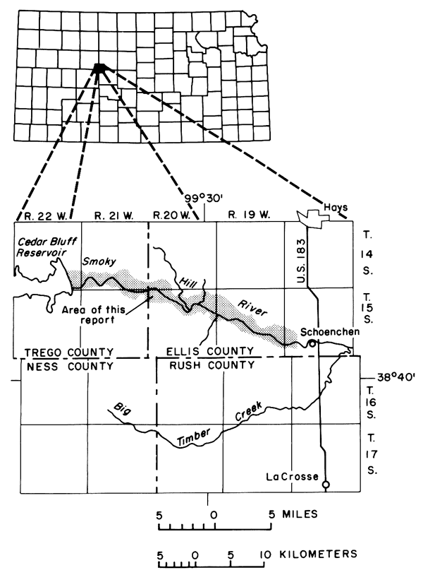
The Cedar Bluff Irrigation District was selected for the study because the natural equilibrium of the semiarid hydrologic environment had only recently been upset by irrigation that began in 1963. No critical pollution problems were known to exist, but degradation in the chemical quality of low streamflow of the adjacent Smoky Hill River by drainage from the irrigation district could adversely affect the municipal water supply for the city of Hays which is obtained from wells in the valley alluvium about four miles downstream from the study area. Pertinent background information describing the geology and water resources is available from published reports by Hodson (1965) and Leonard and Berry (1961) and unpublished data in the files of State and Federal agencies. Useful data also were collected on a routine basis from existing observation wells and recording gages by personnel of the U.S. Bureau of Reclamation and the irrigation district as part of the operation of the Cedar Bluff Dam and district.
The Cedar Bluff study is unique in Kansas because it began soon after the first irrigation season and before return How became a significant component of streamflow adjacent to the district. Data representing the preirrigation base line are scarce, but progressive changes in water quality caused by irrigation could be separated from natural variations as the district converted from range land and dryland farming to intensive cultivation under irrigation. Increased crop diversification, livestock production, and use of chemicals are peripheral results of irrigation that may complicate the water-quality picture. However, the effects on water quality of cultural factors other than irrigated agriculture appeared to be relatively insignificant or amenable to measurement. The irrigation water from Cedar Bluff Reservoir and runoff through or from the sparsely populated drainage area of the district seem to be relatively unaffected by municipal or industrial effluent. Ground water withdrawals in the district are generally small and widely scattered.
Objectives and Scope of the Study
The principal objective of the study was to evaluate the progressive effects of irrigation with water from Cedar Bluff Reservoir on the chemical quality of ground water and surface water in and adjacent to the newly established irrigation district. A secondary objective was to relate the changes in the chemical quality of water to natural and manmade factors in the environment to a sufficient degree that the relations would be useful for water-resources evaluation and planning. Development of a precise hydrologic model for use as a planning tool is beyond the scope of this investigation, but most of the data collected are applicable to that type of endeavor.
A wide variety of data was collected and analyzed by different methods to evaluate their application to the potential problem of quality deterioration resulting from irrigation. If the results serve as guidelines for selection of the type and minimum quantity of data needed for similar or related investigations of the movement of inorganic pollutants or of artificial recharge under somewhat similar geohydrologic conditions, an implied objective of the study has been attained.
Approach
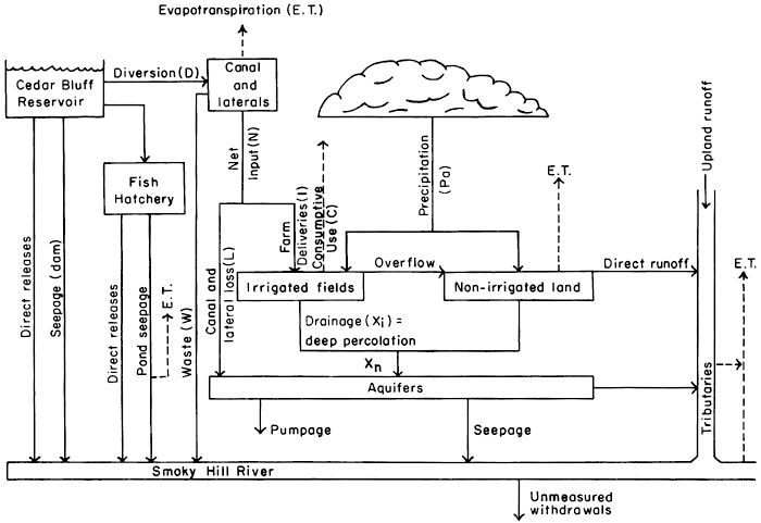
A large volume and wide variety of basic data were collected at the sites shown in plate 1 between 1964 and 1971 to describe semiquantitatively the system shown schematically in figure 2. The data include measurements of precipitation, water levels and water discharge; lithologic and gamma-ray logs of observation wells and test holes; chemical analyses of ground water, surface water, and soil; analyses for pesticides in ground and surface water; and selected particle-size analyses of soil. Except where noted in the text, water analyses were performed in the Division of Environment laboratory, Kansas Department of Health and Environment. The methods of analysis generally were those recommended in "Standard Methods for the Examination of Water, Sewage, and Industrial Wastes" (American Public Health Association and others, 1971). Definitions of technical terms, as used in this report, are summarized in the glossary. Some were from publications of the U.S. Department of Agriculture and the Federal Water Pollution Control Administration (now Environmental Protection Agency). Extensive use of existing digital-computer programs (Lowell, et al., 1970) facilitated compilation and analysis of the varied and voluminous data.
Figure 2--Diagram of the local hydrologic system.
Only the most significant part of the basic data is reproduced herein, and that part mostly in graphical form. Data have been released in the U.S. Geological Survey annual series "Water Resources Data for Kansas, Part 2. Water Quality Records," in interpretative progress reports (Leonard 1969a, b, 1970), and in a compilation (Leonard and Stoltenberg, 1972) intended for limited distribution to researchers engaged in similar or related studies. Information relating to the operation of the irrigation district and Cedar Bluff Reservoir was drawn freely from published and unpublished reports of preliminary investigations, work plans, and operations provided by the U.S. Bureau of Reclamation, McCook, Nebr. and by Mr. Robert Schamel, Manager, Cedar Bluff Irrigation District. Observation-well information not included in published reports are on file at the U.S. Geological Survey, Lawrence, Kans.
The data are used to describe the geohydrologic setting in sufficient detail to relate the physical and chemical properties of the system to the quantity and quality of water passing through it. Input of water and salts is estimated from the measured quantity and quality of irrigation water, the quantity and distribution of rainfall, and estimates of the quantity of water returned to the atmosphere by crops.
Recorded changes in the altitude and configuration of the water table and in the concentrations of the major ions in ground water in and adjacent to the irrigated area reflect the arrival, distribution, lateral migration, and discharge of water in and from the ground-water reservoir. Detailed data are used to relate corresponding changes to the geology, distribution of water, and changes in the chemistry of the soil profile in three experimental plots.
Data from sixteen seepage-salinity surveys describe the quantity and quality of ground-water discharge from the district and its effect on low streamflow of the Smoky Hill River. Additional data collected at more frequent intervals at four stations adjacent to the district describe streamflow over a wider range of conditions. Estimates of the quantity and quality of drainage from the district based on the results of the salinity surveys were compared with estimates based on continuous records and with estimates based on irrigation requirements and distribution of the irrigation water.
English units of measurements used in this report are given in equivalent metric units (in parentheses) using the following conversion factors:
| English units | Multiply by | Metric units |
|---|---|---|
| inch (in) | 2.54 | centimeter (cm) |
| foot (ft) | .3048 | meter (m) |
| mile (mi) | 1.609 | kilometer (km) |
| acre | .4047 | hectare (ha) |
| 4.047 x 10⁻³ | square kilometer (km2) | |
| square mile (mi2) | 2.590 | square kilometer (km) |
| gallon (gal) | 3.785 | liter (l) |
| cubic foot (ft3) | .02832 | cubic meter (m3) |
| cfs-day (ft2/s-day) | 2447 | cubic meter (m3) |
| acre-foot (acre-ft) | 1233 | cubic meter (m3) |
| 1.233 X 10⁻³ | cubic hectometer (hm3) | |
| cubic feet per second (ft3/s) |
.02832 | cubic meters per second (m3/s) |
| gallons per minute (gpm) | .06309 | liters per second (l/s) |
Numbering System for Wells and Soil-sampling Sites
Wells and soil-sampling sites are numbered according to the Bureau of Land Management's system of land subdivision. The first set of digits of the location number indicates the township south of the north border of Kansas, which is the 40th parallel; the second set, the range west of the sixth principal meridian; and the third set, the section in which the well is situated. The first letter denotes the quarter section, or 160-acre tract; the second, the quarter-quarter section, or 40-acre tract; and the third (when shown), the quarter-quarter-quarter section, or 10-acre tract. The quarter sections, quarter-quarter sections, etc., are designated A, B, C, and D in a counterclockwise direction beginning in the northeast quarter section. For example, well 14-21W-27DAD is in the SE NE SE sec. 27, T. 14 S., R. 21 W. (fig. 3).
Figure 3--Numbering system for wells and soil-sampling sites.
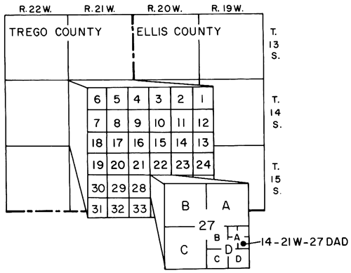
If more than one well is in the same tract, consecutive numbers beginning with 2 are added to the letters in the order in which the wells were installed. To simplify the description and graphical illustration of experimental plots, the closely spaced wells therein are designated by the last letter and number in consecutive order beginning with 1.
Prev Page--Glossary || Next Page--Location and Geohydrologic Setting
Kansas Geological Survey, Geohydrology
Placed on web Nov. 2012; originally published 1975.
Comments to webadmin@kgs.ku.edu
The URL for this page is http://www.kgs.ku.edu/Publications/Bulletins/CQS1/03_intro.html