Kansas Geological Survey, Bulletin 96, part 2, originally published in 1952
Prev page--Report Start
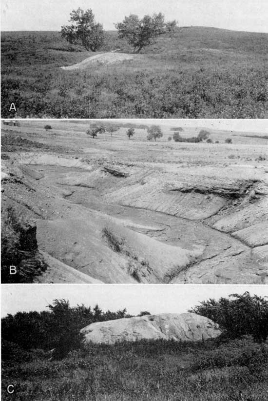
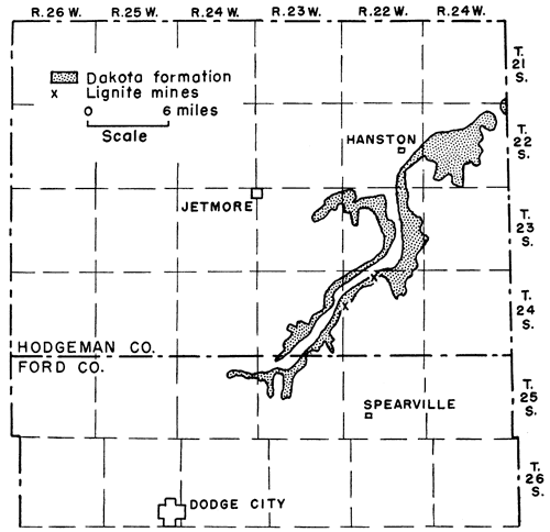
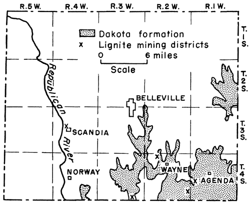
The Dakota formation forms the bedrock of a triangular-shaped area of approximately 6 to 7 townships in the western part of the county (Fig. 6). No outcrops of lignite were seen in the field nor are there any published references to Clay County lignite outcrops in the geologic literature. Lignite, however, was formerly mined 50 or more years ago at one locality in the county. The mine, a drift mine, now represented by a dump heap (Pl. 3A) is located on the south bank of a small stream approximately in the NE cor. NW sec. 28, T. 6 S., R. 1 E. about 4 1/2 miles due east of St. Joseph in Cloud County. Two hundred feet south of the dump heap and 25 to 30 feet higher is a circular depression now mostly filled which may have been the site of a shaft. The lignite is reported to have been 18 inches thick and has been encountered in a number of near-by water wells. Judged by the character of the materials composing the mine dump, the coal or lignite occurred in a shale. Massive reddish-colored Dakota sandstone crops out approximately at the same elevation as the partially filled circular depression referred to above and continues to crop out on the slopes still higher. No data are at hand as to the amount of coal mined, by whom, depth to the coal, or the exact time of mining. The mine is not included in any of the published reports of the State Coal Mine Inspector.
Figure 6--Map of Clay and Cloud counties, Kansas, showing distribution of the Dakota formation and the location of lignite mines.
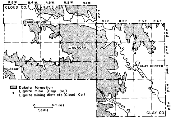
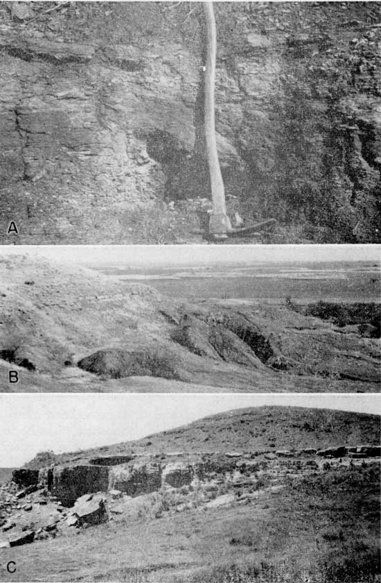
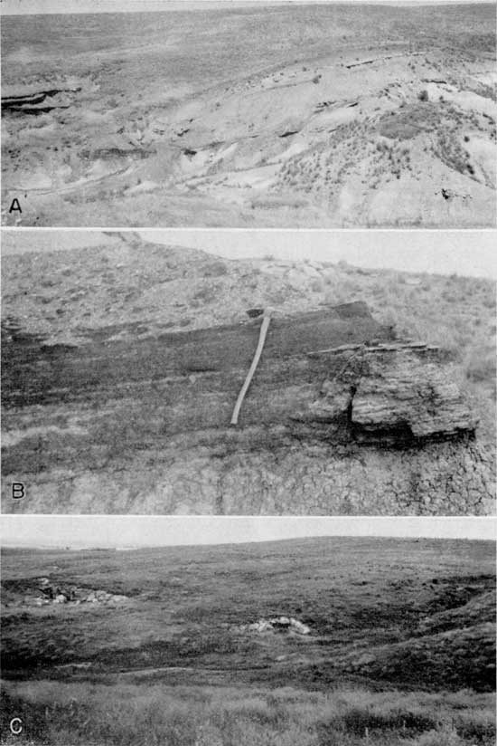
Plate 3--Lignite mines and outcrop. A, Mine dump of only known lignite mine in Clay County. Portal of mine in depression flanked by trees. Channel Dakota sandstone marks horizon. B, Lignite outcrop (dark band) in ravine southwest of Elmo, in sec. 24, T. 16 S., R. 1 E., Dickinson County. C, Mine dump 3 miles east of Jewell in sec. 34, T. 4 S., R. 7 W., Jewell County. The mine is 160 feet deep and the lignite from 30 to 36 inches thick.
Reserves--On the basis of an 18-inch seam of lignite there were about 400,000 tons of coal originally under the 160 acres considered here as marginal reserve coal land. It is believed that the amount mined was not great and would not change materially the reserve tonnage of this coal as estimated. It is therefore listed as this figure in this report.
More than 40 percent of all lignite mined in central Kansas was produced in Cloud County. The Dakota formation forms the surface rocks of approximately 11 of the 20 townships that comprise the county. The coal-bearing strata are found chiefly in the eastern two tiers of ranges and the easternmost tier of townships (Fig. 6). The occurrence and mining of lignite in Cloud County were known as early as 1855 (Wing, 1930, p. 43). Coal is reported last mined in 1940 (Delplace, 1941, p. 10).
Minersville mining district--Of the five localities in the county where lignite is reported to have been mined, the most important one is the Minersville coal mining district from 5 to 6 miles north and 1 1/2 to 3 miles east of Concordia, primarily in secs. 1 and 2, T. 5 S., R. 3 W. The mining district extended northward into sec. 35, T. 4 S., R. 3 W. in Republic County. Minersville, now entirely abandoned, was a mining community of several houses, a hotel, stores, and a U.S. post office (Pl. 2C).
Figure 7--Map of the Minersville lignite mining district, Cloud and Republic counties, Kansas.
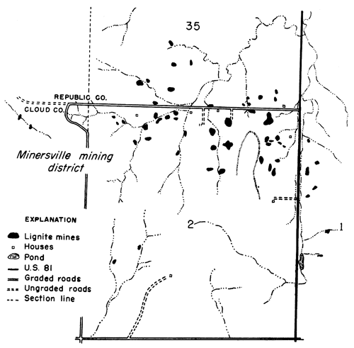
As reported to me by Mr. D. Curtis the coal seam is 22 to 24 inches thick and is divided into an upper 6 to 8-inch coal which is separated from a lower 12-inch seam by 3 to 4 inches of impure coal or "blackjack." The average thickness of the lignite reported by the various coal mine inspectors is 22 inches. Outcrops of the lignite are essentially absent in the area where the mines are located. The only good outcrop of the coal seen in the Minersville mining district is in Republic County in the NW cor. SW sec. 26, T. 4 S., R. 3 W. about 1 1/4 miles north of the northernmost mine of the area. The lignite at the outcrop measures 25 inches in thickness. The coal in the Minersville district occurs 12 feet below the sandstone forming the top of the Dakota formation (Whitla, 1940, p. 33) and 102 feet below the Jetmore limestone of the Greenhorn formation (Wing, 1930, p. 44). The coal is over and underlain by shale. The lignite was mined in shaft and slope mines and chiefly by the longwall system. On the lower ground some of the lignite was obtained by stripping methods. The coal lay at various depths below the surface. In 1875 the shafts were 25 feet deep, in 1890 the mines averaged 55 feet in depth, in 1899 they averaged 75 feet, and the last mines opened were in the neighborhood of 100 feet. None of the mines had railroad connections. All the coal was sold as mine-run coal and hauled away by the wagon load to points as much as 20 to 30 miles distant. The mines were small affairs and employed from 4 to 14 men each. The miners were paid from $1.25 to $2.50 a ton for mining the coal which was sold at prices from $2.25 to $4.00 per ton at the mines. Most of the mines operated for six months or less during the year; others, however, were active during the entire year as is suggested by the fact that the price paid to the miners during the summer months was slightly less than the pay they received per ton for mining the coal during the winter months.
The presence of lignitic coal is also recorded in the logs of test holes put down on the flood plain of Republican River north of Concordia (Fishel, 1948, pp. 177-180). The lignite is encountered at a depth of 78 to 97.5 feet beneath the valley floor surface and in the test hole put down in the SE cor. sec. 19, T. 5 S., R. 3 W. the lignite is 2 feet thick. It is apparent from the geologic relationship that the lignite in this test hole found at a depth of 80 feet below the Republican River flood plain is not at the same stratigraphic horizon at which the coal was mined 3 to 4 miles farther north in the Minersville mining district. The test hole lignites are presumably to be correlated with the lignite cropping out in the basal part of the Dakota formation south of Elmo in Dickinson County.
Concordia mining district--According to a Cloud County map (Sims, 1883, p. 32) published in 1883, coal occurred in sec. 16, T. 6 S., R. 3 W., from 2 to 3 miles south of Concordia. A search for this coal mine proved futile as did the location of another mine shown on the map in sec. 26, T. 6 S., R. 4 W., near the former town of Graves. Evidence of a mine, however, reported by a local resident to have existed about 1 mile west of the Graves mine was found in a pasture in the Cen. NE sec. 34, T. 6 S., R. 4 W. on the Wilcox farm. This mine is represented by a circular shaft depression about 12 feet in diameter and now 5 feet deep. No other information was obtained relative to the mine.
Glasco mining district--Coal is also shown on the Sims' (1893) map in sec. 4, T. 8 S., R. 4 W. about 4 miles east and 1 to 2 miles north of Glasco. All field traces of any mining activity that may have existed are gone and if any coal was mined as reported the mine must have been very small. Inquiry at Glasco and in the general area where the coal was reported to have been led to the discovery of a place in the NW sec. 10, T. 8 S., R. 4 W., a mile farther south and about one-half mile east where coal was formerly taken from the bank of a small stream. At the time of my visit to the place alluviation had so filled up the valley floor that only the capping sandstone of the Dakota formation was exposed.
Aurora mining district--Sims' (1883) map of Cloud County also shows coal to be present in Aurora Township, secs. 18 and 26, T. 7 S., R. 2 W. The locality in sec. 18, about 3 miles west of Aurora, is in the Carlile shale and Graneros limestone formations. Search for the mines in this section and inquiry concerning them at Aurora and vicinity yielded no results. South of Aurora about 2 miles, coal was seen in the SW cor. sec. 23 where it also was mined and in the NW sec. 26. Half a mile farther south in the same section the lignite was reported to have been mined. All the lignite seen was very thin, from 2 to 8 inches thick, and cropped out no more than 2 feet above creek level and from 50 to 60 feet below the lowest limestone in the Greenhorn limestone formation. Without doubt the lignite seen was not the seam that was mined formerly. Mr. LaBarge, an old resident of Aurora, reported to me that coal was mined south of Aurora more than 60 years ago and that he as a youngster helped his father haul some of the mined coal away in partial payment for certain moneys which the owner of the mine owed Mr. La Barge's father. Because of the gentle slopes that prevail in this part of Cloud County and the excessive slumping found almost everywhere where erosion has caused gullies, outcrops of lignite are extremely difficult to find in the Aurora area.
West Pipe Creek mining district--A coal mine was also reported to me by Mr. Will Callahan who lives on a farm in the NW sec. 12, T. 8 S., R. 3 W. This mine is about 1 1/4 miles west and 1 mile north of Callahan's house and is 0.35 mile west and 0.15 mile south of the NE cor. sec. 3, T. 8 S., R. 3 W. When seen the remains of the mine, a spot of mine debris worn down to the level of the surrounding surface, was in the midst of an oats field and never would have been found except for the help of a nearby farmer and a knowledge of the exact location. No information was obtained regarding the mine except that the coal was last mined more than 50 years ago and that much water was encountered in the mine.
Production--The coal at Minersville was probably the first lignite mined in central Kansas. As reported by Wing (1930, p. 43) mining probably started in 1855. Mr. D. Curtis, now living where Minersville formerly was located and whose father settled there in 1872, related to me that mining at Minersville was in full progress by 1872. Data on coal production are incomplete. The first coal officially reported mined was for 1875 when 500 tons of lignite were produced. Three years later production had reached 10,000 tons and in 1884, 16,000 tons of coal were mined (if the coal sold at $2.50 a ton, the prevailing price at that time and the published value $40,000 is correct). Production data are given in Table 7 for the years beginning with 1875. It will be noted that no tonnage is listed for 1936 to 1940. It is not to be presumed that no coal was mined in Cloud County during that period or in the other years for which no data are available. On the basis of published data Cloud County produced a minimum of 130,753 tons of lignite (Table 7).
Table 7--Published lignite production data for Cloud County, Kansas.
| Year | Tons | Year | Tons | Year | Tons | ||
|---|---|---|---|---|---|---|---|
| 1875 | 500 | 1891 | 7,040 | 1901 | 8,876 | ||
| 1878 | 4,000 | 1893 | 3,588 | 1902 | 5,561 | ||
| 1880 | 1,000 | 1894 | 3,700 | 1936 | 670 | ||
| 1883 | 1,333 | 1895 | 5,000 | 1937 | 50 | ||
| 1884 | 16,000 | 1896 | 5,500 | 1938 | 50 | ||
| 1885 | 4,118 | 1897 | 2,800 | 1939 | 50 | ||
| 1887 | 8,000 | 1898 | 400 | 1940 | 50 | ||
| 1889 | 7,313 | 1899 | 6,146 | ||||
| 1890 | 6,800 | 1900 | 7,208 | Total | 130,753 |
Reserves--Since all the lignite mined and known to occur in the county is less than 3 feet thick all reserve lignites of Cloud County are classified as marginal coal reserves. Furthermore, a thickness of 1 foot was considered as the average thickness of the original coal reserves since lignite of a lesser thickness would hardly have been mined by shafting or drifting methods. It is estimated that, prior to mining there was in Cloud County approximately a minimum of 5,300,000 tons of coal of 1 foot thickness and that the reserves as of June 1, 1950, amount to 5,200,000 tons. Coal reserves for the various mining districts in Cloud County are recorded in Table 8.
Table 8--Marginal lignite reserve lands and tonnage in Cloud County, Kansas. Reserves estimates are stated to three significant figures or less.
| Mining district |
Location | Thickness, inches |
Reserves, tons |
|---|---|---|---|
| Minersville | 1, 2, 3-5-3W | 12 | 1,700,000 |
| Concordia | 34-6-4W | 12 | 900,000 |
| Glasco | 10-8-4W | 12 | 900,000 |
| Aurora | 23, 26-7-2W | 12 | 900,000 |
| West Pipe Creek | 12-8-3W | 12 | 900,000 |
| Total | 5,300,000 | ||
| Production | 130,753 | ||
| Reserves | 5,200,000 | ||
Elmo area--No coal or lignite has been reported to occur or to have been mined in Dickinson County. However, 3 miles south and from 1 1/2 to 5 miles west of Elmo (Fig. 8) lignite is exposed in several ravines. The best outcrop is in the SW cor. SE sec. 24, T. 16 S., R. 1 E. where the lignite, 22 inches thick, is exposed in the sides of a short ravine just north, of the east-west section-line road (Pl. 3B). Beneath the lignite is a dark-gray to blackish clay shale that contains numerous and large well-developed selenite crystals and pieces of pyritized logs. Small gypsum veins cut the upper part of the shale, of which 7 to 10 feet is exposed. Overlying the lignite is 48 inches of silty shale or light-cream to yellowish siltstone, the lower 30 inches of which is thin-bedded and the upper 18 inches made up of layers 1 to 2 inches thick. The entire unit tends to weather down into small fragments or chipstones. The lignite dips westward. The coal is to be seen again south of the east-west section-line road in sec. 25 where it ranges in thickness from a featheredge to 30 inches. A mile east and about 0.2 mile south of this road, in sec. 8, T. 16 S., R. 2 E., the lignite seam is 8 inches thick. At this outcrop the coal is overlain by 3 to 4 fleet of gray shale which is capped by a 3-inch sandstone. A fourth exposure of the coal is in the NW cor. NE sec. 27, T. 16 S., R. 1 E., approximately 2 1/4 miles west of the first outcrop. At this easternmost outcrop the coal is associated with black shale 18 to 24 inches thick. The lignite zone rests on 5 feet of gray shale which lies on top of a thin-bedded limy siltstone that weathers to chipstones and small sheet or platelike fragments. The overlying rock is soft white to iron-stained sandstone 5 or more feet thick (Fig. 9).
Figure 8--Map of Dickinson County, Kansas, showing distribution of the Dakota formation.
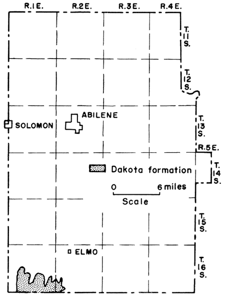
Figure 9--Stratigraphic sections measured in Dickinson and Ellsworth counties, Kansas, showing the position of the lignite in the Terra Cotta member of the Dakota formation.
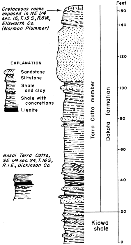
Stratigraphic position of the lignite--The Dickinson County lignite differs from that in the other counties described in this report in that it does not occur in the upper part of the Dakota formation. The lignite is either in the basal part (Terra Cotta member) of the Dakota formation or is in the upper part of the Kiowa shale. It is not always possible in the field to distinguish with certainty the base of the Terra Cotta clay member of the Dakota formation from the upper part of the Kiowa shale. According to Plummer and Romary (1942, pp. 331-332) differentiation between the two stratigraphic units can be made only by ceramic and other tests that show the mineralogic characteristics of the two rock units. Permian strata crop out no more than 1 mile east of the coal exposures and typical Dakota channel sandstones cap the much higher surrounding hills to the west of the coal localities. Plummer (personal communication) is of the opinion that the coal horizon is in the Terra Cotta member of the Dakota formation (so classified here). Similar lower Dakota formation lignite has been encountered in test holes drilled on the flood plain of Republican River several miles north of Concordia in Cloud County. Plummer (Moore and others, 1951, p. 26) also measured a section in Ellsworth County in which lignite occurs in the lower part of the Terra Cotta member (Fig. 9).
Proximate analysis--A sample of the coal collected in sec. 24, T. 16 S., R. 1 E. was analyzed. Table 2 shows that the Dickinson County sample has by far the highest ash content and the lowest B.t.u. value of all the samples analyzed. It should be noted that the coal has been exposed for a very long time and even though much of the face of the coal was removed before taking the sample, no real typical or good sample could be obtained.
Reserves--No more, than 160 acres of land can be classified as reserve coal land in secs. 24 and 25. On the basis of the coal averaging 20 inches in thickness it is estimated that the 160 acres contain approximately 500,000 tons of marginal lignite reserves.
As far as is known no lignite has been produced in Dickinson County.
The Dakota formation is the dominant bedrock in Ellsworth County and is found in each of the county's 20 townships (Fig. 10). As reported by Saunders (1873, pp. 389-390) who probably made the first chemical analysis of the Kansas Cretaceous lignite, lignite was mined along Wilson Creek, a south-flowing tributary to Smoky Hill River, just east of Wilson a few years before 1872. The coal in Ellsworth County where mined ranged in thickness from 12 to 36 inches and was in all respects similar to the lignite mined elsewhere in the other Cretaceous coal-bearing counties of central Kansas. The mines were chiefly of the shaft and drift or slope type although some stripping was done. The underground mines were worked on the longwall system. Several seams of coal, at some places five or six, occur in the upper part of the Dakota formation. In 1895 two coal seams were reported being mined (Brown, 18,96, p. 65) 3 miles south of Wilson.
Figure 10--Map of Ellsworth County, Kansas, showing distribution of the Dakota formation and the location of lignite mining districts.
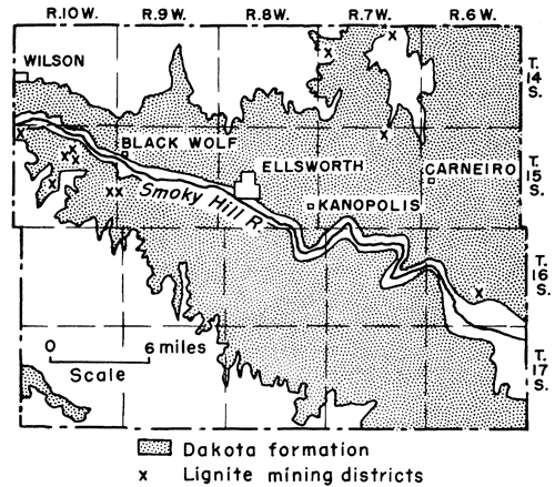
All the mines, most of which were worked only during the winter months, were small and employed no more than three to a dozen or so men. The prevailing selling price of the coal was $3 to $3.25 a ton. No coal has been reported mined in Ellsworth County since 1902. The coal was used primarily for heating houses but some was used to burn lime (Gray, 1874, p. 142) and some to fire railroad locomotives (Hutchinson, 1871, p. 63; Anonymous, 1951, p. 209; Malin, personal communication). The lignite was mined in at least five localities within the county and is known to occur at several other places (Fig. 10).
Coal Creek-Smoky Hill River mining district--One of the important, if not the most important, of the mining districts in the county was along Smoky Hill River and its north-flowing tributaries about 3 miles due south of Wilson in the northwestern part of the county. This mining district extended westward into adjacent Russell County (Fig. 11) where it continued along Coal Creek (see Russell County). The coal south of Wilson is found in the SW cor. sec. 31, T. 14 S., R. 10 W. and in the NW sec. 6, T. 15 S., R. 10 W. The coal crops out and the mine dumps follow the steep slopes of a short unnamed north-south gulch headed into Smoky Hill River Valley (Plate 4B). Most of the mines were on the west- or east-facing slope of the rock spur whose west and also west-facing slopes are in Russell County. Some of the mines in later years extended entirely across the rock spur, a distance of approximately 1,000 feet, and had their portals in one county and their exits in the other county. Evidences of six mines were noted in the two Ellsworth County sections. In 1890 the I. H. Baldridge mine was a double drift mine consisting of 2 mines running parallel to each other and 40 feet apart. One of the mines was used as an inlet and the other as the outlet. The coal was mined on the longwall system and rooms branched to the right of one mine and to the left of the other so that the ventilation in the mines was very good (Stewart, 1891, pp. 27-29).
Figure 11--Map of the Coal Creek-Smoky Hill River lignite mining district, Ellsworth and Russell counties, Kansas, showing location of mines and marginal lignite reserve areas. On map read "marginal" in place of "emergency" lignite reserve lands.
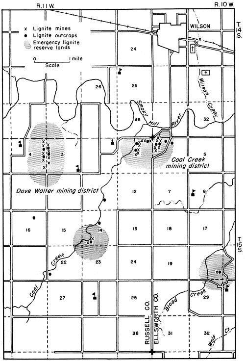
Plate 4--Smoky Hill River-Coal Creek mining district, Ellsworth County, and mine in Lincoln County. A, Outcrop of lignite, sec. 6, T. 15 S., R. 10 W. Adz at base of lignite, top of seam at top of dark band above horizontal sample drill hole. Lignite 17 inches thick overlain by 7 1/2 inches of laminated lignitic clay shale. B, Mine dumps just north of outcrop shown in A. Smoky Hill Valley in upper background. C, Mine portal between two massive siltstones, the lower one of which is 10 feet thick. The mine is in the East Elkhorn Creek mining district in sec. 32, T, 13 S., R. 7 W., Lincoln County.
The lignite crops out at a number of places in the two sections. A section measured (Fig. 4) in the gulch in sec. 6 shows the coal to be 20 inches thick and lying between two siltstones, the upper one of which is 8 inches thick and the lower one 24 inches thick. At this locality four other coal seams from 2 to 5 inches thick occur within a zone of shales and siltstones 12 feet thick (Pl. 4A). According to the reports of the coal mine inspectors the mined coal ranged in thickness from about 8 to 20 inches. About 1 1/2 miles south of these mines was another mine, the Vandine (Brown, 1896, p. 65) which according to the report was in operation in 1895, employed five men, and produced 600 tons of coal. A search for this mine was unsuccessful and no one in the neighborhood knew of its existence. Another mine not seen by me is along Wilson Creek just east of Wilson on what was then the Kansas Pacific Railroad (now the Union Pacific Railroad). It was from this mine that the first lignite coal was sampled and analyzed (Saunders, 1873, pp. 389-390; 1896, pp. 32-33). A special search for this mine was made on April 26, 1951, without discovering its location. Nowhere within a radius of one-half mile from where the Union Pacific Railroad crosses Wilson Creek is there any indication of a former mine or any trace of the Dakota formation. All material seen is sand and silt which presumably conceals the former mine site if the mine really existed. It may be that the Wilson Creek mine along the Kansas Pacific Railroad may actually have been several miles south of the railroad for in a business directory entitled St. Louis to Denver, for 1870 and published (presumably in 1870) by N. W. Josselyn and Co. of St. Louis is found the following excerpt (Anonymous, 1951, p. 209):
Wilsons Station. A 'wood and water' station, 239 miles from State line. . . Coal is found about 5 miles south of here and is being worked but it is not of a very good quality.
Apparently a better grade of coal must have been mined in the Wilson area if a statement made in connection with the town of Ellsworth has any merit. According to the agent who recorded his candid impressions in the business directory just cited "A vein of anthracite coal is being mined near the western boundary line of the county [Ellsworth], and is delivered at the railroad for $8 per ton."
Coal samples 1, 2, and 3 were collected in sec. 6, T. 15 S., R. 10 W. Proximate analyses of these samples are presented in Table 2.
Blood Creek mining district--Lignite coal occurs in secs. 10, 15, 16, and 20, T. 15 S., R. 10 W. between 5 and 7 miles southeast of Wilson. In the SE sec. 20 a 12-inch lignite seam showed evidence of having been mined by stripping the coal from a small bench or shoulder at a point 15 feet above creek level and about 0.2 of a mile west of the north-south section-line road. The coal is overlain by a soft white sandstone 1 to several feet thick and is underlain by white and yellowish clay. In the NW cor. sec. 15, 12 inches of lignite crops out 2 feet below the top of the Dakota formation which here is represented by 6 inches of iron-stained sandstone. Above the sandstone is typical Graneros black fissile shale containing many well-developed selenite crystals. Between the sandstone and the coal is 2 feet of black fissile shale much like the Graneros shale. The measured section (Fig. 4) also shows 10 feet of black fissile shale beneath the coal, 9 to 12 inches of dirty-gray ripple-marked siltstone, and about 15 feet of white and yellow-brown clay. This same seam crops out in the bluffs in the SW cor. sec. 10 and NE cor. sec. 16. Approximately 1 mile to the east in the SE cor. sec. 10 and NW cor. sec. 15 the coal contains a large amount of clay and is as much as 30 inches thick. It underlies a 6-foot siltstone, the lower part of which is white and in the form of a single bed, whereas the remaining upper 5 feet is thin-bedded. Above the siltstone is at least 12 feet of soft white siltstone which has a tendency to weather into chipstones. Some lignite was mined here by stripping along the outcrop. The coal horizon is also exposed in the bluffs on the west side of the gulch several hundred feet wide and opposite the coal outcrop. The stratigraphic relationships are somewhat different on the west side of the gulch from that seen on its east side. The coal zone is much more shaly and silty, shows cross-bedding at a high angle, and has a thickness of 10 feet. The overlying siltstone is only 10 to 12 inches thick and is overlain by 10 feet of dark-gray clay shale above which is sandstone 5 to 6 feet thick. In the SW cor. sec. 10 the coal is essentially pure lignite and is 12 inches thick.
Black Wolf area--Lignite also is found in sec. 19, T. 15 S., R. 9 W., and in sec. 24, T. 15 S., R. 10 W., from 1 1/2 to 2 miles southwest of Black Wolf. The lignite occurs within a dark-gray to black fissile shale. Rapid changes in the character of the lignite and adjacent rocks are common and the entire sequence of strata shows a pronounced dip (Pl. 5A). At about the SE cor. SW NW sec. 19, T. 15 S., R. 9 W., the lignite zone (Pl. 5B) consists of a top layer of lignite 12 inches thick below which is a 3-inch pure white clay or kaolin resting on a 3-inch layer of black powdery material overlying a lignitic silt to clay 17 inches thick. A gray siltstone (the uppermost part of the Dakota formation here) 15 inches thick is found 7 feet 7 inches above the lignite. Below the lignitic zone is clay containing an interbedded siltstone. The detailed measured section is shown in Figure 4. According to Whitla (1940, p. 37) the lignite ranges from 13 to 18 inches of pure lignite to a zone of alternating bands of lignite and white sand to a carbonaceous clay. Plummer (Whitla, 1940, p. 38) reports 5 feet of clayey lignite, 3 feet of which probably would burn, in the same area. No record of lignite having been mined in the Black Wolf area is known.
Plate 5--Wolf Creek area, Ellsworth County, and the Gettes-McDonald mine, Lincoln County. A, View showing the dipping nature of the strata exposed in sec. 19, T. 15 S., R. 9 W., southwest of Wolf Creek, Ellsworth County. The lower strata constitute the Dakota formation, the upper rocks belong to the Graneros shale and Greenhorn limestone formations. B, Close-up of lignitic zone showing thickness and dip. Upper 12 inches lignite, lower 2 feet black lignitic silt to clay. Lignite interbedded in shale and clay. Same locality as in A. C, Portal to Gettes-McDonald drift mine in sec. 24, T. 13, S., R. 8 W., Lincoln County. The mine opening is immediately below a massive sandstone seen better to the left of the mine. The general absence of outcrops and the difficulty of finding the mine located in the middle of the section are well illustrated in this view.
Ellsworth area--A lignitic clay 3 to 4 inches thick was observed in a road cut south of Oxide Creek in the SW cor. SE sec. 33, T. 15 S., R. 8 W., about 2 1/2 miles southeast of Ellsworth. The impure coal is 37 feet below a massive cross-bedded sandstone which marks the top of the Dakota formation. A coal 3 feet thick was reported to me to have been penetrated at a depth of about 100 feet in a test well drilled for water at the municipal airport in the SE sec. 16, T. 15 S., R. 9 W. This coal, however, upon further investigation proved to be but a few inches thick and according to the geology of the area is in the basal part of the Dakota formation. No coal has been produced in the immediate Ellsworth area.
Venango or Kanopolis Dam mining district--A 26-inch lignite seam is reported to have been mined at or near the former town of Venango in the early 1880's (Sims, 1883, p. 233). Venango was located in the southern part of Ellsworth County in the NW sec. 27, T. 16 S., R. 6 W., just east of the north end of the Kanopolis Dam. Search for the mine was without success. A man operating a large earth-removing shovel near the dam informed me at the time of my visit on July 16, 1947, that he plowed up lignite, near the present spillway of the dam (about 1 1/2 miles south of the former townsite). According to this individual there were two seams of lignite, one of which was 2 inches thick and the other 12 inches. The lignite reported mined in 1880 apparently is related to the 12-inch seam. No production figures are available for the Venango mining district.
Carneiro mining district--Lignite was mined about 3 miles north and 2 to 2 1/2 miles west of Carneiro in the NW sec. 2, T. 15 S., R. 7 W. Evidences of 12 mines, mainly drift mines and one or two strip mines, are still to be seen on both sides of a small north-flowing stream. The coal, according to Mr. W. W. Shoemaker, a resident of the area and one who helped mine the coal 60 to 65 years ago, was from 12 to 16 inches thick and lay at an average depth of 20 feet. According to him 25 to 30 men were engaged in getting the coal. Entries extended into the hillsides for several hundred feet. Apparently some of the coal was mined by stripping (Whitla, 1940, p. 38). It is impossible in the field to tell the exact stratigraphic horizon at which the lignite seam occurred. A dark iron-stained sandstone crops out 15 to 20 feet above the coal dump heap and forms the surface rock in this vicinity. The coal sold for $4.00 a ton and was hauled as far as Wilson, 25 miles distant. Lignite 1.5 feet thick crops out in the SW sec. 23, T. 14 S., R. 7 W., about 2 miles due north of the mines just referred to. This lignite occurs 5 feet below the top of the Dakota formation. Four miles still farther north in the SE sec. 2, T. 14 S., R. 7 W., a very short distance south of the Ellsworth-Lincoln County line, are the Crossgrove and Whitehead drift mines. Mr. Shoemaker also helped mine the coal here which according to him measured 12 inches in thickness, although pockets of 3-foot coal were encountered and mined.
East Elkhorn Creek mining district--Coal was obtained from several drift mines in secs. 7 and 8, T. 14 S., R. 7 W., about 1 1/2 miles south of the Ellsworth-Lincoln County line. Mr. Henry Briand who lives in sec. 8 stated to me that the coal was mined 65 years ago and as late as about 1917. The coal ranged from 16 to 24 inches in thickness and was found at a depth of 75 feet. The coal was obtained by drifting into the hillsides and was mined by 12 to 15 men during the fall and winter months. The coal sold for $3.00 a ton and was hauled by the wagonload to Lincoln and Ellsworth, towns 12 and 15 miles distant, respectively. A royalty of 25 cents per ton was paid to the Union Pacific Railroad, owner of the mineral rights.
Buff-Cow Creeks area--Coal was reported to have, been mined in T. 14 S., R. 9 W., east of Wilson and northwest of Ellsworth before but not after 1875 (Gray, 1875, p. 269) in veins from 7 to 24 inches thick and at a depth of 45 feet. No evidence of the mines was seen nor did people of the community know of their existence. A thin lignite seam 2 to 6 inches thick was observed in the south bank of a small stream in the SE SW sec. 23, T. 14 S., R. 9 W.
Production--The first year for which lignite production is officially listed is 1883 when 3,450 tons of coal was reported mined It is clear that coal was mined much earlier but apparently only in small amounts. The last year for which production is listed is 1902 when only 20 tons of lignite was reported mined. A minimum total of 41,229 tons of lignite is recorded for Ellsworth County (Table 9).
Table 9--Published lignite production data for Ellsworth County, Kansas.
| Year | Tons | Year | Tons | Year | Tons | ||
|---|---|---|---|---|---|---|---|
| 1883 | 3,450 | 1890 | 5,000 | 1897 | 1,427 | ||
| 1884 | 3,450 | 1891 | 6,048 | 1898 | 96 | ||
| 1885 | 3,308 | 1892 | 1899 | 195 | |||
| 1886 | 1893 | 2,400 | 1900 | 2,510 | |||
| 1887 | 3,000 | 1894 | 2,100 | 1901 | 2,730 | ||
| 1888 | 1895 | 2,000 | 1902 | 20 | |||
| 1889 | 5,035 | 1896 | 2,000 | Total | 41,229 |
Reserves--There are no known lignite deposits in the county having a thickness of 3 feet. All reserves, listed here therefore are considered marginal coal reserves. Before mining Ellsworth County had an original reserve of approximately 8,800,000 tons of coal. Of this amount a minimum of 41,229 tons is recorded as having been mined, leaving thus in the ground as of June 1950, a total of about 8,800,000 tons of lignite coal. Table 10 gives data relative to the reserve coals of Ellsworth County by mining districts.
Table 10--Marginal lignite reserve lands and tonnage in Ellsworth County, Kansas. Reserves estimates are stated to three significant figures or less.
| Mining district |
Location | Acres | Thickness, inches |
Reserves, tons |
|---|---|---|---|---|
| Coal Creek-Smoky Hill River | 6-15-10W | 502.66 | 20 | 1,500,000 |
| Blood Creek | 10, 15, 16, 20-15-10W | 1,507.98 | 12 | 2,600,000 |
| Black Wolf | 19-15-9W | 502.66 | 12 | 900,000 |
| 24-15-10W | ||||
| Carneiro | 2-15-7W | 502.66 | 12 | 900,000 |
| 23-14-7W | 900,000 | |||
| East Elkhorn Creek | 7,8-14-7W | 502.66 | 20 | 1,500,000 |
| Venango-Kanopolis Dam | 27-16-6W | 500,000 | ||
| Total | 8,800,000 | |||
| Production | 41,229 | |||
| Reserves | 8,800,000 | |||
Point of Rocks mining district--A narrow strip (1 to 4 miles wide) of the Dakota formation crops out along Buckner and Sawlog Creeks in the southeastern part of Hodgeman County and to a small extent in adjoining Ford County (Fig. 12). Lignite has been reported mined at two localities in Hodgeman County. The southernmost mine was on the west bank of a north-flowing creek tributary to Sawlog Creek in the NW sec. 18, T. 24 S., R. 22 W. The coal underlies a thick massive sandstone which at this locality forms the caprock of the Dakota formation. The coal is supposed to have been 3 feet thick, was mined 50 years or so ago, and burned with such an intense heat that the grates of the stoves usually were burned through in a short time. All evidence of the mine, a drift mine, is obliterated as the creek has completely buried the mine portal and mining debris under at least 15 feet of sand, silt, and mud, a condition repeated at the more northerly mine on the south bank of Sawlog Creek, 2 1/2 miles farther north and 2 miles east in the SW sec. 33, T. 23 S., R. 22 W. Although search was made for outcrops of lignite in Hodgeman County, no coal was seen. About 1 mile east of Hanston, also known as Olney, in the SW sec. 24 and the NW sec. 25, T. 22 S., R. 22 W., the upper part of the Dakota formation is well exposed. Plummer (personal communication) reported the presence of thin lignite at this locality but at the time of my visit in July 1948 I found only two horizons of black fatty clay where normally elsewhere the lignite is known to occur.
Figure 12--Map of Hodgeman and northern Ford counties, Kansas, showing distribution of the Dakota formation and the location of the two lignite mines in Hodgeman County.
Alleged lignite area--Between Sawlog and Whitewoman Creeks south of a promontory known locally as Point of Rocks and extending a short distance into Ford County is an area reported to be underlain by lignite. The presence of the lignite is reported from numerous drill and seismic holes penetrating to depths of 63 to more than 100 feet in the search for oil and gas in Hodgeman and Ford counties. The coal is asserted to range in thickness from 3 to 12 feet. A sample of the coal given me and reported to have come from one of the test holes is a black, brittle, shiny pure coal which may be classified as a high-grade black lignite. According to the information at hand no coal is reported to occur west of Sawlog Creek, a fact apparently corroborated by field evidence and the stratigraphic section measured by me in the SE sec. 13, T. 24 S., R. 23 W. (Fig. 13). The coal on the basis of the test holes thus far drilled is thought to underlie a northeast-southwest trending area approximately 2 miles wide and 7 miles long or a total of 14 square miles. The maximum thickness of coal reported is 12 feet with most of the coal along the margins of the field as outlined by the test holes measuring 3 feet. The exact limits of the alleged field which extends southward into Ford County is not known. A coal sample submitted to the State Geological Survey and the samples of coal given to me subsequently at the time of my visit to the area are similar to the black lignite cropping out along the bluffs of Smoky Hill River in the NE sec. 6, T. 15 S., R. 14 W. about 7 miles south and 3 miles west of Russell in Russell County.
Figure 13--Stratigraphic section of the Dakota formation measured in sec. 13, T. 24 S., R. 22 W., Hodgeman County, Kansas.
Alleged lignite reserves--No outcrops of the lignite were seen in the field and knowledge of the coal, its thickness, and distribution are known only from reported information based upon drilled test holes. The presence of the coal is accepted and is based on the veracity of the reports and suggested by broad geologic field relationships. The coal reserves are therefore classified as alleged lignite reserves in contradistinction to marginal, potential, or inferred reserves, all of which are supported by more data. Computation of the alleged coal reserves, based on an isopachous map drawn from data furnished me and giving the thicknesses of the lignite in the various test holes, indicates that the alleged Hodgeman-Ford County coal reserve lands contain approximately 105,000,000 tons of lignite.
Jewell County is entirely underlain by Cretaceous strata but nowhere, with the exception of a very small area along Buffalo Creek in sec. 13, T. 5 S., R. 6 W., is the Dakota or lignite-bearing, formation exposed (Fig. 14). Mudge (Gray, 1875, p. 298) as early as 1874 reported surface coal from 15 to 20 inches thick was being used locally in the southeastern corner of the county and in the same year T. B. Carpenter, Secretary of the Jewell County Agricultural Society, also stated that coal existed but not in paying quantity.
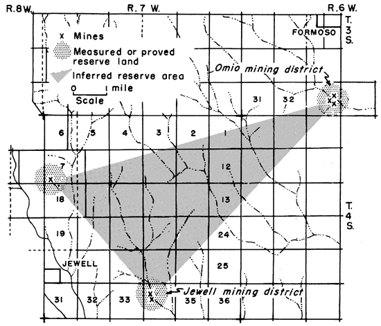
Figure 14--Map of Jewell County, Kansas, showing location of lignite mining districts.
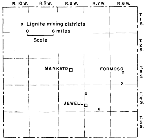
Omio mining district--There are two and possibly three places in Jewell County where lignite was formerly mined. The first of these is in the SE sec. 35, T. 3 S., R. 6 W., at a place where formerly the town of Omio was located. With the coming of the railroad in 1887 the town of Omio was moved 3 miles to the north to become the town of Formosa. The Omio coal was discovered accidentally by G. W. Wade in drilling a water well to a depth of about 150 feet (Findley, 1888, p. 8). The coal encountered measured 3 or more feet thick, a figure both published and given to me by a number of people of the Omio neighborhood. According to Mrs. Tom Shedden, who came to Omio in 1882, talk of mining was then in progress and shortly after that a local mining company was organized. By 1886 or earlier coal was being mined. Eight shaft mines supposedly operated in this district. The main mine was on the south bank of a creek about 100 feet west of the present north-south road to Formosa. A second mine was located north of the creek about 300 feet north of the bridge and 200 feet west of the Formosa road. This shaft mine is evidenced today by a circular depression, now almost completely filled, 10 feet in diameter. Evidences of other near-by mines are to be seen by the presence of mining debris now leveled down to ground level and scattered among the cultivated fields. The mines encountered a large amount of water which was so salty that when pumped out and drained into the pools of the surrounding marsh killed all the fish in the ponds and streams. Mrs. Shedden informed me that in the early years of mining the mines were operated day and night and that a large amount of lignite which sold for about $3.00 a ton was produced. Mining in the Omio district came to an end about 1900.
Jewell mining district--The other Jewell County coal mines now represented by large dump piles and an old shaft (Pl. 3C) are in the NW sec. 34, T. 4 S., R. 7 W., about 5 1/2 miles south and a like distance west of the Omio mines. Jewell is practically 3 miles due west of the mines. Like the Omio mines, the lignite was discovered while drilling for water. The coal lay at a depth of 160 feet and was from 30 to 36 inches thick. According to published reports a thick hard sandstone overlies the coal. The first of the two mines found in this district was sunk in about 1901. According to the Jewell City Republican in an issue of 1904 a block of coal 36X36X36 inches and weighing 900 pounds was taken out of the mine by Mr. Smithmeyer, superintendent of the mine. Sometime in April of 1904 a new shaft was started and by September it was connected with the tunnels of the old mine in order to drain mine waters into the old mine. The Jewell mines, known as the Basye and Wallace mines, experienced considerable water trouble and many delays due primarily because of strikes. Advertisements in the Jewell City Republican for 1904 and 1905 were to the effect that the coal was being sold at from $3.00 to $4.00 a ton. The mines operated last in about 1907. Mining was done by the longwall method. The mines were without railroad connections although the Missouri Pacific Railroad tracks were only half a mile farther south.
It is not clear whether coal was mined or encountered at a third locality north of Jewell. According to Casselman (1903, p. 25) the Waconda Oil and Mining Company in 1901 sank a shaft 3 miles north of Jewell to a depth of 165 feet where they found a 32-inch seam of good-quality lignite. Much trouble was encountered in the sinking of this shaft as a vein of quicksand was penetrated that yielded a large amount of salt water. In May 1902 the superintendent of the mine, Mr. Edward Keegan, was accidentally killed by falling 60 feet to the bottom of the shaft. In the same report (Casselman, 1903, p. 20) is a description of the Waconda Coal and Mining Company's No. 1 mine. This mine, however, is 3 miles east of Jewell. The coal reported in mine No. 1 was 34 inches thick. Whether the two reported mines are separate mines, one north and the other east of Jewell or whether the two mentioned mines are really one and the same mine, the one east of Jewell, is not clear. According to Casselman the north mine is reported to have been closed down after the fatal accident in May 1902. The east mine produced about 1,000 tons of coal in 1902 and was last reported as an active mine in 1907. On the basis of thickness of coal, location of mines, production data, and slight differences in the names of the mining companies it is reasonable to assume that there was a mine located north of Jewell and another east of the town.
Production--Published coal production figures (Table 11) for Jewell County total 9,963 tons. Of this amount 2,000 tons came from the Omio mines and 7,963 tons was produced in the mines east of Jewell which began mining in 1902 at the time when the Omio mines were no longer operating.
Table 11--Published lignite production data for Jewell County, Kansas.
| Year | Tons | Year | Tons | |
|---|---|---|---|---|
| 1885 | 800 | 1902 | 1,000 | |
| 1889 | 800 | 1905 | 2,833 | |
| 1890 | 400 | 1906 | 4,070 | |
| Total | 9,963 |
Proved or measured reserves--According to the criteria used by the Fuels Branch of the U.S. Geological Survey an isolated drill hole, mine, or outcrop may be considered to determine an original area of coal extending for a radius of half a mile around the hole, mine, or outcrop. On this basis the original lignite reserves of Jewell County are approximately 7,400,000 tons, a figure which might also be used for the reserves of the measured lignite as of June 1, 1950, since the total production is less than 10,000 tons. The estimated reserves are shown by districts in Table 12.
Table 12--Lignite reserve lauds and tonnage in Jewell County, Kansas. Reserves estimates are stated to three significant figures or less.
| Mining district |
Location | Thickness, inches |
Acres | Original reserve, tons |
Production, tons |
Measured reserve, tons |
|---|---|---|---|---|---|---|
| Omio | 35-3-6W | 36 | 502.66 | 2,600,000 | 2,000 | 2,600,000 |
| Jewell East | 34-4-7W | 30-36 | 502.66 | 2,500,000 | 7,963 | 2,500,000 |
| Jewell North | 7-4-7W | 32 | 502.66 | 2,300,000 | 2,300,000 | |
| Totals | 7,400,000 | 9,963 | 7,400,000 | |||
Inferred or potential reserves--The presence of lignite at approximately the same depth and reported thickness at three separate localities, the statement that the coal is supposed to have been of good quality, and the belief by practically everyone between Omio and Jewell that the coal underlies the area between the two places suggest that the entire 5 by 8 mile triangular area defined by the three occurrences of coal (Fig. 15) is underlain by lignite having an average thickness of at least 16 inches (one-half the reported average thickness at the three tested localities). On this basis Jewell County has a reserve of inferred or potential lignite coal to the extent of about 22,400,000 tons or a grand total of 29,800,000 tons of lignite of all classifications (Table 6).
Figure 15--Map of part of Jewell County, Kansas, showing lignite mining districts, proved or measured lignite reserve lands, and inferred or potential lignite reserve area.
Of the lignite-bearing counties in Kansas, Lincoln County ranks fourth in production. All the county, with the exception of the alluvium in the major river valleys, is underlain by rocks of Cretaceous age. The Dakota or lignite-bearing formation is the most widespread formation in the county, covering approximately 11 of its 20 townships (Fig. 16). Lignite coal occurs and has been mined in T. 10 S., Rs. 9 and 10 W.; T. 11 S., R. 9 W.; and T. 13 S., Rs. 7 and 8 W. The coal is from 16 to 24 inches thick and where seen in sec. 33, T. 13 S., R. 7 W., lies between two massive sandstones (Pl. 4C).
Figure 16--Map of Lincoln County, Kansas, showing distribution of the Dakota formation and location of the lignite mining districts.
East Elkhorn Creek mining district--The best exposure of lignite is in the SW cor. NW sec. 33, and approximately in the Cen. SE sec. 32, T. 13 S., R. 7 W. Both places are about half a mile north of the Lincoln-Ellsworth County line. The coal observed in a short deep ravine in the SW cor. NW sec. 33 is 2 feet thick. It is over and underlain by massive siltstone. The lower siltstone is 10 feet thick and is separated from the coal by a 3-inch layer of silty lignitic shale or clay. The overlying siltstone is soft, irregularly bedded, iron-stained, and 6 feet thick. Beneath the underlying siltstone is about 30 feet of gray shale containing siltstones and thin layers of iron-stained sandstone. On top of the 6-foot overlying soft siltstone is a 5-foot dark-gray shale, 12 feet of gray shale with sandstone layers, 4 feet of dark-gray shale containing selenite crystals capped by about 1 foot of brownish ironstone. Immediately above the ironstone is 15 feet of typical Graneros gray shale filled with well-developed selenite crystals. About one-fourth mile farther west and a short distance south in the SE sec. 32 are two abandoned drift mines (Pl. 4C). As reported by Whitla (1940, pp. 45-46) the coal zone between the two massive siltstones is 42 inches thick. The upper siltstone measures 4 feet thick whereas the lower one is 10 feet in thickness. The coal at the entrance to one of the drift mines is 24 inches thick and forms the lower part of the coal horizon; the upper 18 inches is lignitic clay. According to Whitla (1940, p. 46), "Ten feet back from the entrance the entire thickness of beds between the two sandstones is lignite." Proximate analyses of lignite sampled in sec. 33 (No. 13 and 14) are given in Table 2.
West Elkhorn Creek mining district--About 3 miles northwest of the East Elkhorn Creek mines in the NE sec. 24, T. 13 S., R. 8 W. are the J. Gettes and McDonald mines. These mines are close to West Elkhorn Creek. The mines are drift mines and extend into the hillside slopes just beneath a sandstone or siltstone of variable thickness. No outcrops of lignite were seen anywhere in the vicinity of the mines. Outcrops of rocks of any kind are exceedingly few in the entire section of land in which the mines occur (Pl. 5C). Data on thickness of coal, when, and how much mined are not available.
Ash Grove mining district--Most of the Lincoln County coal mines are in the northwest part of the county in the area several miles north of Denmark and at Ash Grove and vicinity between Bacon Creek and South Branch of Spillman Creek (Fig. 17). A shaft mine 55 feet deep was located about one-fourth mile north and one-fourth mile east of the school house and church at the northeast corner of Ash Grove or about at the NE cor. SW sec. 20, T. 10 S., R. 9 W. The coal, according to Mr. J. D. Hayden, a blacksmith at Ash Grove and one of the early coal miners in that community, averaged 15 inches in thickness and was mined chiefly from 1881 to 1896. Ten to 15 men were normally employed at the mine. The mine today is represented by a dump heap 150 to 200 feet in diameter and a filled-in shaft depression about 10 feet in diameter. The coal mined was reported in 1893 as being at Allamead (Gallagher, 1894, p. 59), a town formerly located 2 miles east and half a mile north of Ash Grove. Inquiry and field evidence indicate that no mine ever existed at Allamead and that the only mine known close by was the one just northeast of Ash Grove. The coal mine shaft was located on the N. B. Alley farm and according to Brown (1896, p. 77) 210 tons of coal were mined in 1895 by six men. The shaft opening is situated on a rock terrace which stratigraphically is in the upper part of the Graneros shale. The coal was discovered accidentally in the process of putting down a water well. The coal horizon apparently is in the upper part of the Dakota formation.
Figure 17--Map of the northwestern part of Lincoln County, Kansas, showing the location of lignite mines, mining districts, and marginal lignite reserve lands. On map read "marginal" instead of "emergency" lignite reserve lands.
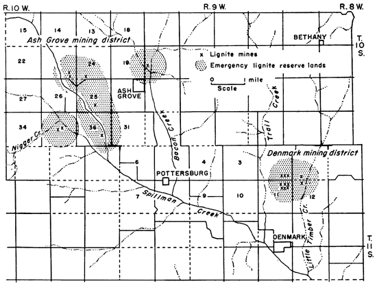
Coal 18 to 20 inches thick was mined 2 miles due west of Ash Grove in the SW sec. 24 and in the SE sec. 23, T. 10 S., R. 10 W. The mine in sec. 24 was a shaft mine 60 feet deep whereas the two mines in sec. 23 now represented by dump heaps were drift or slope mines. Another shaft mine was in the SE sec. 25 where the coal was reported to have been 14 to 18 inches thick. Along the north branch of Spillman Creek in the SE sec. 36, T. 10 S., R. 10 W. is evidence of a slope mine close to the creek and about 50 feet below the general upland level. This mine is approximately 1 1/4 miles north and 1 1/2 miles west of the former townsite of Pottersburgh. Other shaft mines operated about 1895 and before were located in the Cen. sec. 35, T. 10 S., R. 10 W. along South Branch Spillman Creek.
Denmark mining district--Coal was mined in the SW sec. 1; SE sec. 2; NE sec. 11; NW sec. 12, T. 12 S., R. 9 W., about 2 miles north of Denmark. The coal mined was from 18 to 24 inches thick and was separated into two seams by a thin parting or band of blackjack or lignitic clay. The mines in the Denmark district were all shaft mines and were from 50 to 60 feet deep. There were at least three mines in sec. 2, six in sec. 11, and one each in secs. 1 and 12.
Other reported mining districts--Coal was also reported to occur and to have been mined in Madison Township, the southeastern-most township in the county. No mines or evidences of mines or lignite outcrops were seen in this part of the county or are known by residents of the township. A shaft mine 45 feet deep and having a coal seam 22 inches thick was reported (Gallagher, 1894, p. 60) to have been sunk in 1893 at a locality 2 miles north and 1 1/2 miles west of Vesper. Vesper is approximately 7 miles due west of Lincoln. This mine, known as the Andrew Nelson mine, must have been either in the southern part of sec. 26 or in the northern part of sec. 35, T. 11 S., R. 9 W. Since either place is remote from any known coal mines in the county it is more likely that the mine was 2 miles north and half a mile west of Denmark where several coal mines had been worked. L. B. Nelson in 1898 (McGrath, 1899, p. 9) operated a coal mine in the SW sec. 1, T. 11 S., R. 9 W., about 2 miles north of Denmark and along Little Timber Creek.
Production--Coal from 10 to 20 inches thick was discovered cropping out along the banks of some of the streams in Lincoln County especially in T. 11 S., R. 9 W. north and northwest of Denmark as early as 1875 (Gray 1875, p. 316; Mudge, 1875, p. 125). Although some coal north of Denmark had been mined to a limited extent (Hudson, 1881, p. 242) as early as 1879 no official coal production for Lincoln County was reported until 1884 when 1,100 tons was mined. The last year for which production is reported is 1902. Lincoln County produced a minimum total of 39,493 tons of coal insofar as published records reveal. Without doubt more coal was mined than reported. Data published relative to lignite production in Lincoln County are presented in Table 13.
Table 13--Published lignite production data for Lincoln County, Kansas.
| Year | Tons | Year | Tons | Year | Tons | ||
|---|---|---|---|---|---|---|---|
| 1883 | 1,100 | 1890 | 6,600 | 1897 | 750 | ||
| 1884 | 1,100 | 1891 | 6,768 | 1898 | 350 | ||
| 1885 | 2,775 | 1892 | 1899 | 400 | |||
| 1886 | 1893 | 2,400 | 1900 | 400 | |||
| 1887 | 2,920 | 1894 | 2,400 | 1901 | 714 | ||
| 1888 | 1895 | 2,000 | 1902 | 437 | |||
| 1889 | 6,499 | 1896 | 1,800 | Total | 39,493 |
Marginal reserves--Since all the mined lignite was less than 3 feet in thickness with the possible exception of some that may have been mined in the East Elkhorn Creek mines, all the reserves in Lincoln County are classified here as marginal reserve coals. Original reserves previous to mining total slightly more than 10,500,000 tons in Lincoln County. Of this amount 39,493 tons have been mined, leaving thus about 10,500,000 tons of lignite still in the ground. Table 14 presents data by districts on lignite reserves in Lincoln County.
Table 14--Marginal lignite reserve lands and tonnage in Lincoln County, Kansas. Reserves estimates are stated to three significant figures or less.
| Mining district |
Location | Thickness, inches |
Reserves, tons |
|---|---|---|---|
| East Elkhorn Creek | 32,33-13-7W | 24 | 1,000,000 |
| West Elkhorn Creek | 24-13-8W | 12 | 900,000 |
| Denmark | 1, 12-10-9W | 20 | 1,500,000 |
| 2, 11-10-9W | 20 | 1,500,000 | |
| Ash Grove | 20-10-9W | 14 | 1,000,000 |
| North Branch Spillman Creek | 25-10-10W | 16 | 1,200,000 |
| 23, 24-10-10W | 19 | 1,400,000 | |
| South Branch Spillman Creek | 36-10-10W | 14 | 1,000,000 |
| 35-10-10W | 14 | 1,000,000 | |
| Total | 10,500,000 | ||
| Production | 39,493 | ||
| Reserves | 10,500,000 | ||
Very little of the Dakota or lignite-bearing formation crops out in Mitchell County (Fig. 18). In the Solomon River Valley between Simpson and Beloit the upper part of the formation forms the bluffs on both sides of the valley as it does along Salt Creek in T. 9 S., R. 7 W. The sandstone is reddish, cross-bedded, and sufficiently resistant to form a fairly distinct bench.
Figure 18--Map of Mitchell County, Kansas, showing distribution of the Dakota formation and the location of the lignite mining districts.
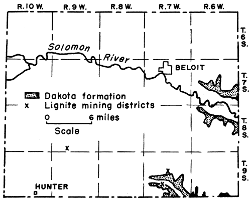
Salt Creek mining district--Thin lignite seams were seen in the south bluffs of Salt Creek in the NE cor. sec. 28, T. 9 S., R. 7 W., where also in former years the coal was mined. Evidence of an old drift mine was still seen in spite of the tremendous amount of slumping or small scale landsliding that had taken place and which made it impossible to get good data on the coal. The lignite is reported to have had an average thickness of 14 inches (Stewart 1892, p. 37) and was mined by drifting. The mines of this area were crude and in constant need of attention and were worked primarily and during the winter months by farmers and their families. The coal was sold locally. Saltville, no longer existent, in the SE sec. 9, T. 9 S., R. 7 W., was the center of the Mitchell County coal mining district. According to Stewart (1891, pp. 44-45) two drift mines were in operation at Saltville in 1890. About 20 men were employed mining the coal. According to Whitla (1940, p. 52) coal 14 inches thick was drift-mined in sec. 21, T. 9 S., R. 7 W. during the years before 1900. These mines may well have been the same as those referred to above in sec. 28 on the south side of Salt Creek. Local residents knew of no mines in sec. 21.
Landes (1930, p. 54) states that a coal mine was reported to him to be in the NW cor. sec. 22, T. 9 S., R. 8 W., along Rock Creek. A search for this mine, however, proved futile and no one in that vicinity knew or ever heard of it. A more likely place for this mine would have been 6 miles due east in the NW cor. sec. 22, T. 9 S., R. 7 W., along Fifth Creek and about 1 1/4 miles south of Saltville which served as the center of the Salt Creek mining district and where coal might logically be expected to be present. The country rock at the location cited by Landes is Carlile shale, Greenhorn limestone, and the top of the Graneros shale. The nearest Dakota outcrop is 3 miles east of the supposed location of the mine.
Solomon River Valley mining district--Lignite mines were also reported (Logan, 1897, p. 209; Crane, 1898, p. 143) to have been present in the Solomon River Valley. These mines although searched for were not seen or located by me.
Hunter mining district--A mine supposedly was operated years ago (Landes, 1930, p. 54) in the SE sec. 32, T. 8 S., R. 9 W., about 5 miles north and 2 1/2 miles east of Hunter. No information is available on this mine except that it was along the banks of a small north-flowing tributary of Walnut Creek and that its portal was in the Blue Hill shale, the uppermost member of the Carlile shale formation. The top of the Blue Hill shale in Mitchell County lies approximately 400 feet above the top of the Dakota formation. It is therefore reasonable to assume that any coal that may have been mined at this locality was not the Dakota lignite. No positive proof of the mine or any mining dump material was to be seen at the time of my visit to the place where I was told the mine was located. However, a farmer who lives on the quarter section of land where the mine was informed me that the deed to his farm specifies that his ownership of the land does not include the mining rights for that quarter section of land.
Production--The Mitchell County lignite was known and mined to a limited extent as early as 1875 (Gray, 1875, p. 34) from seams reported to have been from 15 to 30 inches thick although later reports gave the coal a thickness of 12 to 14 inches. The coal sold for $2.00 a ton and was used locally. Production figures for Mitchell County are very incomplete (Table 15) and none are reported by the State Coal Mine Inspector after 1891. It seems that following that year the State coal mine inspectors were unable to locate the mines and on inquiry at Saltville were told that no mines were known to exist near by (Gallagher, 1894, pp. 65, 66). As far as official published reports are concerned Mitchell County produced a total of 3,148 tons of lignite.
Table 15--Published lignite production data for Mitchell County, Kansas.
| Year | Tons | Year | Tons | |
|---|---|---|---|---|
| 1879 | 80 | 1890 | 948 | |
| 1880 | 120 | 1891 | 1,040 | |
| 1889 | 960 | Total | 3,148 |
Marginal reserves--The original coal reserves of Mitchell County are estimated at 500,000 tons.
The coal-bearing Dakota formation is found chiefly in the southern part of the county in T. 4, Rs. 1, 2 and the eastern one-half of R. 3 (Fig. 19). Several sections in the vicinity of Haworth, sec. 36, T. 2 S., R. 1 W., are also underlain by the Dakota formation. Coal has been mined at several localities in the county and since at least 1875 (Gray, 1875, pp. 385-386) and probably as early as 1855 (Wing, 1930, p. 43).
Figure 19--Map of Republic County, Kansas, showing distribution of the Dakota formation and the location of lignite mining districts.
Scandia mining district--Coal from 16 to 20 inches thick is reported as having been mined at Scandia between 1891 and 1893 when the shaft was abandoned and later caved in (Gallagher, 1894, p. 80). According to old settlers and a retired well driller at Scandia, lignite 3 to 4 feet thick was struck in drilling a water well 3 miles north and 3 miles west of Scandia in the NW cor. sec. 36, T. 29 S., R. 5 W. Attempts to mine the coal were made and after obtaining some of it water trouble soon put a stop to mining activities here. A similar thick lignite seam was encountered in a well 1 3/4 miles north of Scandia in the NE sec. 5, T. 3 S., R. 4 W. A man fatally injured at this well stopped all further operations for securing the coal. No definite information could be learned relative to the depth of the encountered coal nor to its quality. Scandia and surrounding areas are not in the area of the Dakota formation which crops out at the nearest place about 9 miles southeast of Scandia. The Greenhorn limestone and Carlile shale constitute the bedrock of the Scandia area. Whether the Scandia coal or lignite is Dakota lignite or a stratigraphically higher coal similar to that north of Hunter in Mitchell County is not known.
Norway area--Three and one-half miles east of Norway in the NE cor. sec. 24, T. 4 S., R. 4 W., coal or lignite 3 feet thick was penetrated in drilling a well 120 feet deep. The surface rock at this locality is the Carlile shale formation. On the basis of the thickness of the Cretaceous rocks occurring in Republic County given by Wing (1930, pp. 21-35) the coal seam encountered in the 120-foot well could well have been the Dakota lignite.
North extension, Minersville mining district--The Minersville mining district of Cloud County extends northward into Republic County in sec. 35, T. 4 S., R. 3 W. (Fig. 7, Pls. 2C, 6A) There are eight mines in the SE and seven mines in the SW of the section. The coal is 20 to 22 inches thick and is in all respects similar to that mined in Cloud County. The only good outcrop of lignite seen in the vicinity of the mines is in the NW cor. SW sec. 26, approximately 1 mile north of the northernmost mine in sec. 35. The lignite crops out in ravines and is contained in shales. The seam 25 inches thick consists of an upper 3-inch lignite separated from the lower 12-inch coal by 10 inches of impure coal. Sample 15 was collected at this outcrop and analyzed in the chemical laboratories of the State Survey (Table 2).
Wayne mining district--Lignite was formerly mined from 1 to 2 miles north of Wayne which is in sec. 9, T. 4 S., R. 2 W. Two abandoned drift mines are. along the west bank of a stream in the SE sec. 5, T. 4 S., R. 2 W. The entries to the mines are about 15 feet above creek level and are capped by a 10-foot bed of soft massive Dakota sandstone. Another mine was formerly located along the same stream about one-half mile farther north in the NE sec. 2. The presence of coal is also reported in a water well about half a mile east of the mines (Cen. W2 sec. 4, T. 4 S., R. 2 W.). No other information regarding the mines was learned.
Agenda mining district--Lignite is exposed and was mined 60 years ago by drifting on the Boal farm in the NE SE sec. 19, T. 4 S., R,. 1 W. The mine is 2 miles south and 1 1/2 miles west of Agenda. The lignite varies in thickness and quality in very short distances. Where measured (Fig. 4) the lignite constitutes the lower 17 inches of a 40-inch lignitic zone. Above the lignite is 10 inches of black lignitic clay which in turn is overlain by 4 inches of black sooty lignite. Beneath the lignite is 7 feet 2 inches of ashy white nonbedded siltstone. The lignitic zone is overlain by 9 feet 2 inches of clay and siltstone above which is 15 feet of dark-brown and bright-red sandstone and siltstone. The amount of coal removed is not known but according to Mr. Boal a considerable amount has been mined. Plummer also reported an outcrop of lignite in a road cut at the southeast corner of the same section. This lignite was not exposed at the time of my visit to the place. Another mine was also reported to me to be in the SE cor. NE sec. 25, three-fourths of a mile south and 1 mile west of the Boal lignite. Because of stream alluviation the exact spot locating the mine could not be ascertained with certainty. Proximate analysis of lignite sample 15, collected on the Boal farm, is given in Table 2.
Production--According to published records, Republic County produced a total of 30,790 tons of lignite (Table 16).
Table 16--Published lignite production data for Republic County, Kansas.
| Year | Tons | Year | Tons | Year | Tons | ||
|---|---|---|---|---|---|---|---|
| 1883 | 2,700 | 1891 | 1,056 | 1899 | 1,696 | ||
| 1884 | 2,700 | 1892 | 1900 | 501 | |||
| 1885 | 2,431 | 1893 | 1,605 | 1901 | 525 | ||
| 1886 | 1894 | 2,575 | 1902 | 1,700 | |||
| 1887 | 1895 | 1,724 | 1903 | ||||
| 1888 | 1896 | 2,000 | 1904 | ||||
| 1889 | 998 | 1897 | 1,300 | 1905 | 6,902 | ||
| 1890 | 400 | 1898 | 1906 | 547 | |||
| Total | 30,790 | ||||||
Reserves--According to reports there is 3-foot lignite in Republic County at NE cor. sec. 6, T. 3 S., R. 4 W., northwest of Scandia; NW cor. sec. 36, T. 2 S., R. 5 W., north of Scandia; and NE cor. sec. 24, T. 4 S., R. 4 W. east of Norway. The estimated reserves at these three localities (considered here as inferred coal reserves) totals 7,900,000 tons. Reserve lignite lands in which the coal is less than 3 feet thick and classified as marginal coal reserve lands comprise 1 square mile in the north extension of the Minersville mining district, 1 1/8 square miles in the Wayne area, and 2 square miles in the Agenda area, a total of 4 1/8 square miles containing about 7,700,000 tons of 20-inch coal. An additional 500,000 tons of reserve coal are to be found at Scandia. The total original coal reserves of Republic County amount to approximately 16,100,000 tons and are summarized in Table 17.
Table 17--Lignite reserve lands and tonnage in Republic County, Kansas. Reserves estimates are stated to three significant figures or less.
| Mining district |
Location | Thickness, inches |
Reserves, tons |
|---|---|---|---|
| N. extension, Minersville | 35, 27, 26-4-3W | 20 | 1,900,000 |
| Wayne | 4,5-4-2W | 20 | 2,100,000 |
| Agenda | 19, 25-4-2W | 20 | 3,700,000 |
| Scandia area | 16,17-3-4W | 20 | 500,000 |
| Northwest and north of Scandia | 5, 3-4W | 36 | 7,900,000* |
| 36-2-5W | |||
| Norway | 24-4-4W | ||
| Total | 16,100,000 | ||
| Production | 30,790 | ||
| Reserves | 16,100,000 | ||
| *This is the only lignite in Republic County considered by the U.S. Geological Survey as actual reserves. Others listed are marginal reserves. |
|||
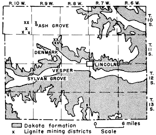
In Russell County the Cretaceous coal-bearing strata follow in the main the valleys of Smoky Hill and Saline Rivers, together with their tributaries (Fig. 20). Lignite was known to occur in the county by at least 1875 (Mudge, 1875, pp. 124-125) for in that year according to Gray (1875, p. 399) considerable coal had been developed. This coal, reported from 30 to 40 inches thick, sold at the mines for $2.00 a ton. Production for 1875 amounted to 500 tons. By 1881 (Hudson, 1881, p. 252; Sims, 1883, p. 437) lignite was reported to be found in nearly all parts of the county and 11 mines were in operation. Of these 11 mines, 2 were in Fairview Township in the northeast part of the county, 3 in Plymouth Township southeast of Dorrance or southwest of Wilson in Ellsworth County, 4 in Center Township northeast of Bunker Hill, and 2 in Russell Township in which Russell is located. These mines, between February 28, 1881, and March 1, 1882, yielded a total of 6,175 tons of lignite valued at $24,000. The capital invested in the mines is reported to have been $6,075. The principal mines by 1897 were located on Wolf Creek and Coal Canyon (Logan, 18,97, p. 209). The Wolf Creek mines were southwest of Lucas whereas the Coal Canyon mines were in the southeastern part of the county. There are at least seven areas in Russell County, possibly nine (Hudson, 1881, p. 252) where lignite was mined (Fig. 20). Coal is supposed to have been mined in Russell and Winterset Townships, although the mines were not located by me.
Figure 20--Map of Russell County, Kansas, showing distribution of the Dakota formation and the location of lignite mining districts.
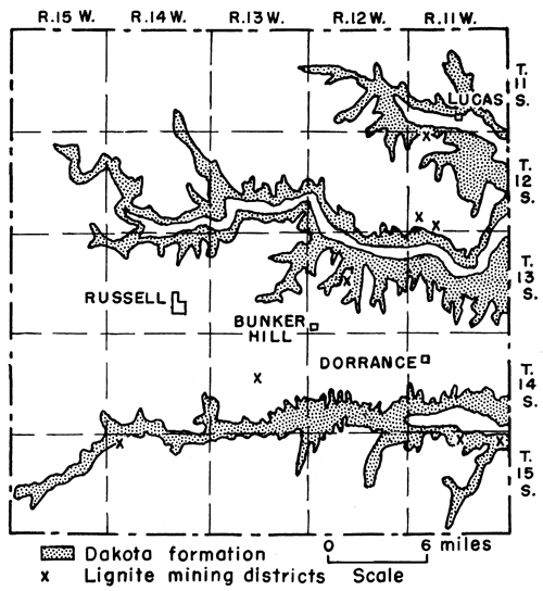
Lincoln Township mining district--Although no mines were located by me in Winterset Township, lignite crops out along Smoky Hill River in the NW sec. 6, T. 15 S., R. 14 W., less than 1 mile east of sec. 1, T. 15 S., R. 15 W., in the northeast corner of Winterset Township. The lignite occurs in shale exposed in the west-facing bluffs of Smoky Hill River. The coal is jet black, shiny, very hard, and where sampled 15 inches thick. The coal cropping out here is by far the best lignite seen in central Kansas and is very similar to the coal sample reported to have come from one of the test holes drilled in Hodgeman County. Immediately above the coal is 1 foot of black lignite shale which is overlain by 7 feet of gray shale, the upper part of which is dark-gray to black. The shale is overlain by 3 feet of red crinkled sandstone above which is 3 feet of grayish shale topped by 1 1/2 feet of red to brownish sandstone. Sand and gravel of variable thickness overlie the sandstone. Beneath the coal is a 6-inch black clay shale containing lignite fragments and 15 feet of well-bedded grayish shale. Figure 4 shows the stratigraphic section measured at this place. A proximate analyses of the coal is given in Table 2 (samples 10, 11, and 12). A comparison with the other samples analyzed shows clearly that this coal is by far superior to the lignites collected elsewhere in the area covered by this report. Evidence of stripping the coal was seen along the outcrop immediately to the west of the place where the coal was sampled. If, as reported in 1881 (Hudson, 1881, p. 252), coal had been mined in Winterset Township immediately to the west of this outcrop in Lincoln Township, then it is evident that the coal must have been mined either in the NW cor. sec. 12 or in sec. 1, T. 15 S., R. 15 W., as farther to the west the Graneros shale crops out at the level of Smoky Hill River.
South Bunker Hill mining district--Lignite averaging 12 inches in thickness was formerly mined in secs. 14, 15, and 22, T. 14 S., R. 13 W., about 2 1/2 to 4 miles southwest of Bunker Hill. The mines in secs. 15 and 22 were close to stream level above which cropped out black Graneros shale. Evidence of four mines was seen in sec. 22 and two mines to the north in sec. 15. A shaft mine was also reported in the NW sec. 14, T. 14 S., R. 13 W., approximately 1 mile east and three-quarter mile north of the mines in secs. 15 and 22. These mines were in operation in 1893 (Gallagher, 1894, p. 81). The shaft mine reported in the NW sec. 14 was known as the Menzes mine. Very little information is known concerning the mines south of Bunker Hill. In 1895 Mr. James Menzes reported (Brown, 1896, p. 98) that the lignite was very extensive in Russell County but was not opened or developed very much and that there was supposed to be a second vein on an average 110 feet lower. The price paid for mining was $2.00 a ton.
Northeast Bunker Hill mining district--A large amount of lignite was mined from 3 to 4 miles northeast of Bunker Hill in Center Township in sec. 21, T. 13 S., R. 12 W. Ten entries of slope mines were observed in the bluffs of a small north-flowing tributary of Saline River about 2,00 feet east of the Bunker Hill-Anspaugh road in the center of the section. In addition a quarter of a mile farther north and the same distance east of the road are evidences of two other slope mines. A section (Fig. 4) measured at the mines shows the coal to be 12 inches thick which according to various reports appears to be the average thickness of the lignite in this part of Russell County. The coal is underlain by shale and overlain by 11 feet 6 inches of massive sandstone which marks the approximate upper part of the Dakota formation. The following stratigraphic section shows the relationship of the lignite to the overlying and underlying strata. Four coal mines were producing here in 1881 (Sims, 1881, p. 437). In 1899 two mines were in operation. The mines were worked on the longwall system. In 1897 the coal sold for $3.00 a ton. A proximate analysis of the lignite sampled in sec. 21 is presented in Table 2 (samples 8 and 9).
| Measured section in sec. 21, T. 13 S., R. 12 W. northeast of Bunker Hill, Russell County, Kansas. | Feet | Inches |
|---|---|---|
| Shale, black fissile | 1 | 2 |
| Sandstone, crinkly | 1 | 0 |
| Shale, gray, well-bedded | 3 | 0 |
| Sandstone, crinkly, iron-stained, weathering into rusty chips | 2 | 0 |
| Sandstone, massive | 6 | 8 |
| Sandstone, pyrite nodules | 4 | 10 |
| Shale, black, fissile | 0 | 8 |
| Lignite | 1 | 0 |
| Shale, gray | 1 | 6 |
| Shale, dark-gray, exposed to creek level | 7 | 6 |
Coal Creek-Smoky Hill River mining district--By far the greatest number of mines in Russell County were located in Plymouth Township south of Smoky Hill River (Fig. 11). Coal was known to occur and mined in the bluffs of Coal Creek by 1879 (Hudson, 1881, p. 252). The lignite crops out at numerous places in the ravines or gulches that are tributary to Smoky Hill River and especially along Coal Creek in secs. 1, 14, and 22, T. 15 S., R. 11 W. Most of the mines are located in sec. 1 about 3 miles south and 1 mile west of Wilson in Ellsworth County. The mines in sec. 1 are the western extensions of the Coal Creek-Smoky Hill River mining district of Ellsworth County. The lignite occurs in six seams within the upper 15 to 17 feet consisting of dark-gray shale and thin siltstones of the upper part of the Dakota formation. The coal or lignite seams range in thickness from 2 to 20 inches and for the most part are overlain by dirty-gray siltstones. The underlying rock is dark-gray shale. According to reports the mined coal was from 12 to 20 inches thick. Entries and mine dumps of eight drift or slope mines are still seen in the west-facing bluffs of Coal Creek in sec. 1 and eight in the gulch no more than one-fourth mile east in the W2 sec. 6, T. 15 S., R. 10 W. in Ellsworth County. Some of the mines extended into Ellsworth County where they connected with the Ellsworth County mines. The coal was mined by the longwall system and sold for $2.00 to $3.00 per ton. The coal also crops out along Coal Creek at a number of places for a distance of 4 miles southwest of the mines in sec. 1. According to Whitla (1940, p. 58) the lignite is from 24 to 28 inches thick along Coal Creek in sec. 14, T. 15 S., R. 11 W. Of this thickness the upper 10 to 12 inches of the seam is free from impurities. The lignite is overlain by at least 4 feet of gray sandstone or siltstone above which is shale. Beneath the coal is a white clay shale or fire clay. Whitla reports that this seam has not been mined but according to Mr. David Walter and a number of other local residents the 12- to 14-inch lignite seam has been mined in the SW of the section. The lignite is also found in the bluffs of sec. 22 where only 6 inches of coal was observed. Lignite was also reported by Mr. David Walter to outcrop at the foot of a terrace in the NW cor. NE sec. 16, T. 15 S., R. 11 W., not quite 2 miles northwest of the coal outcrop in sec. 14. The coal was found as reported but no measurements of thickness could be made due to its position at the foot of the terrace and the heavy grass cover. Pieces of coal were seen, however, by digging into the ground.
Dave Walter mining district--Along the bluffs of a valley or canyon of a north-flowing tributary of Smoky Hill River approximately along the section line between secs. 3 and 4, T. 15 S., R. 11 W., and 2 1/2 to 3 miles due west of the coal mines in sec. 1 are the traces of at least a dozen mines (Pl. 6B). Mr. David Walter, who lives in the SE cor. sec. 4, informed me that formerly a small coal town was located here and that a large amount of coal was mined. Coal was mined last at this locality according to Mr. Walter in 1907. Part of the coal was mined by stripping along the outcrop but most of the mines were drift mines. The coal is on the average about 2 feet thick (Pl. 6C), is overlain by a massive siltstone that varies in thickness in short distances and is characterized by vertical joints and holes which Plummer (Plummer and Romary, 1942, pp. 339) has interpreted to be worm borings, and is underlain by white to brown clay shale. Between the coal and siltstone is 6 to 7 inches of black lignitic shale and immediately beneath the lignite is 6 inches of dark shale. Above the capping sandstone are 3 inches of gray shale, a 10-inch lignite seam, and several thin (2- to 3-inch) siltstones imbedded in a more or less bedded shaly siltstone totaling about 5 feet. The uppermost layer of siltstone which marks the top of the Dakota formation here is brownish and from 10 to 16 inches thick. Fifteen feet of black fissile selenite-bearing Graneros shale overlies the Dakota siltstone. The black fissile shale is overlain by about 5 feet of brown sandy limestone that weathers into small chipstones and that constitutes at this locality the upper surface of a rock bench or terrace. At the time of last mining the coal sold for $4.00 a ton, the owner receiving a royalty of 25 cents for each ton of lignite mined. Samples 5, 6, and 7 (Table 2), probably not too representative of the coal actually mined, were taken along the outcrop in the NE cor. SE sec. 4, T. 15 S., R. 11 W., about one-fourth mile north of Mr. Walter's house. The proximate analysis is given in Table 2.
Plate 6--Republic County mine dump and Dave Walter mining district, Russell County. A, Large mine dump in Minersville mining district, Republic County. Material now being sold and used for road mettle and other purposes. In time the evidence for and location of many mines will thus be obliterated as is the case now. B, General view of Dave Walter mining district, secs. 3 and 4, T. 15 S., R. 11 W., Russell County; view looking north. The inner terrace of the gulch is penetrated by numerous drift mines for a distance of about 1 mile. Formerly a coal-mining town was located here. C, Exposure of lignite 30 inches thick on west side of gulch approximately at the center of the east section line of sec. 4. The lower lignite seam shown is part of the upper seam which has been broken off.
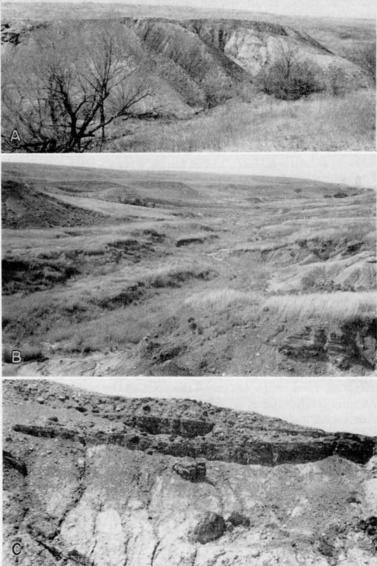
Lucas-Wolf Creek mining district--Coal was being mined along Wolf Creek near Lucas in Fairview Township as early as 1881 (Sims, 1883, p. 437) and in 1897 Logan (p. 209) reported that the principal coal mines in Russell County were located on Wolf Creek and Coal Canyon. Mr. Robert Spaulding of Lucas reported that coal, 11 to 12 inches thick, had been mined in the NE cor. sec. 5, T. 12 S., R. 11 W., as early as 1880. The mine was operated by Mr. John Hole as a drift mine and was located in a small draw tributary to Wolf Creek approximately 1 mile south and slightly more than 1 mile west of Lucas. Considerable coal was supposed to have been produced. The entry to the mine was above a massive poorly exposed sandstone which presumably marked the top of the Dakota formation at this place. Prospect holes, not seen by me however, according to Mr. Spaulding are present in the W2 sec. 5 and in the eastern part of sec. 32, T. 11 S., R. 11 W. The coal of the Lucas area is supposed to have contained much sulfur and on burning to have left a large amount of ash. The coal was used extensively in Lucas and vicinity.
Cooper Ranch-Rocktown mining district--Lignite is known to occur in secs. 29, 30, 31, 32, and 33, T. 12 S., R. 11 W., in the southwest part of Fairview Township, and to have been mined most extensively on the Cooper ranch in sec. 32 (Fig. 21). In reference to the Cooper ranch mining district Mr. Emmet Cooper of Wilson, in a letter to me dated July 5, 1947, states: "There is a strip, at least six miles long east and west, in which there is definite proof of coal deposits--in some cases three different veins at different levels . . . and that hundreds of tons of coal were mined from 1880 to 1890." The mines were located chiefly in the E2 sec. 32, and in sec. 33, T. 12 S., R. 11 W., a place also known as Rocktown. Coal was also mined at the cen. sec. 29, near the S. line sec. 30, and several mines were reported in the NE sec. 31. In addition to the mines lignite as much as 3 feet thick was also reported encountered in several wells in secs. 29, 30, and 32. The coal, which ranged from 12 to 18 inches in thickness, was obtained by drifting for distances of 250 to 300 feet into the north valley walls of Saline River. A second seam of coal also 12 inches thick was exposed in some of the numerous canyons but was not mined. A third seam, 3 feet thick, is reported to have been encountered in several wells, particularly in the SW sec. 29, SW sec. 30, and NW sec. 32. This coal lay from 40 to 50 feet below the middle seam or 65 to 80 feet beneath the upper or mined seam. This lower seam may correspond stratigraphically to the position of the lignite exposed south and west of Elmo in Dickinson County and which has been assigned to the lower Dakota formation. A 3-foot seam of lignite was also reported to me to have cropped out in 1874 at the bottom of a canyon somewhere close to the line between secs. 21 and 28, T. 12 S., R. 12 W., about 5 to 6 miles northwest of the Cooper Ranch. This coal can no longer be seen. The Cooper Ranch coal was discovered by the grandfather of Mr. Emmet Cooper either in the fall of 1879 or spring of 1880 while getting a drink from a spring. Mining ceased in 1890. According to Mr. Cooper hundreds of tons were mined and hauled away by the wagonload to places as much as 70 or more miles distant. The coal was trucked to Smith Center, Lebanon, Beloit, Osborne, Cawker City, and other places in western Kansas. Much of the coal was sold at $3.00 per ton.
Figure 21--Map of the northeastern part of Russell County, Kansas, showing the location of lignite mines, the Cooper Ranch-Rocktown and Lucas-Wolf Creek mining districts, and the reserve lignite areas.
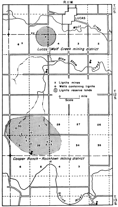
Production--On the basis of published reports Russell County produced from 1875 to 1904 a total of 44,808 tons of lignite. More coal was produced than the published records show as coal was mined as late as 1907 in the Dave Walter mining district and some coal was mined in the Cooper-Rocktown area during the winter of 1938-1939 and sold on the market even though not recorded (Whitla, 1940, p. 58). Production data are given in Table 18.
Table 18--Published lignite production data for Russell County, Kansas.
| Year | Tons | Year | Tons | Year | Tons | ||
|---|---|---|---|---|---|---|---|
| 1875 | 500 | 1887 | 120 | 1896 | 1,000 | ||
| 1878 | 500 | 1888 | 1897 | 181 | |||
| 1880 | 9,400 | 1889 | 6,005 | 1898 | 35 | ||
| 1881 | 1890 | 6,044 | 1899 | 28 | |||
| 1882 | 6,175 | 1891 | 6,044 | 1900 | 11 | ||
| 1883 | 967 | 1892 | 1901 | ||||
| 1884 | 967 | 1893 | 2,100 | 1902 | 27 | ||
| 1885 | 140 | 1894 | 900 | 1903 | 2,718 | ||
| 1886 | 1895 | 600 | Total | 30,790 |
Reserves--The minimum original reserve lignites of Russell County may be estimated at 20,600,000 tons. Of this amount 7,900,000 tons is 3-foot coal, the remainder consisting of lignites from 12 to 24 inches thick and is the coal which was formerly mined to the extent of 44,808 tons. There remains approximately 20,600,000 tons of unmined coal in Russell County of which 12,700,000 tons is classified as marginal lignite reserves and 7,900,000 tons as proved or measured reserves. Reserve lignite data for Russell County are summarized by districts in Table 19.
Table 19--Lignite reserve lands and tonnage in Russell County, Kansas. Reserves estimates are stated to three significant figures or less.
| Mining district |
Location | Thickness, inches |
Reserves, tons |
|---|---|---|---|
| Cooper Ranch-Rocktown | 29,30,31-12-11W | 36 | 7,900,000* |
| 32,33-12-11W | 12 | 2,600,000 | |
| Lucas-Wolf Creek | 5-12-11W | 12 | 900,000 |
| Bunker Hill Northeast | 21-13-12W | 12 | 900,000 |
| Bunker Hill Southwest | 14,15,22-14-13W | 12 | 800,000 |
| Coal Creek | 1-15-11W | 15 | 500,000 |
| 14-15-11W | 12 | 900,000 | |
| Dave Walter | 3,4,9,10-15-11W | 24 | 4,000,000 |
| 33,34-14-11W | |||
| Lincoln Township | 6-15-14W | 15 | 1,100,000 |
| Total | 20,600,000 | ||
| Production | 44,808 | ||
| Reserves | 20,600,000 | ||
| *This is the only lignite in Russell County considered by the U.S. Geological Survey as actual reserves. Others listed are marginal reserves. |
|||
Lignite was known to occur in Washington County as early as 1875 (Mudge, 1875, pp. 124-125). Most of Washington County is underlain by the Dakota formation (Fig. 22) but since most of the lignite occurs in the upper part of the formation outcrops of the coal are necessarily confined to the northwest and west-central parts of the county. Outcrops of lignite are extremely few. The nonresistant character of the Dakota formation together with the thinness of the lignite seams and the excessive slumping on the hillsides are responsible for the concealment of the coal at most places. A 2- to 3-inch seam of lignite was observed in a roadside ditch in the SW cor. NW sec. 35, T. 1 S., R. 1 E., about 4 1/2 miles north of the east edge of Haddam.
Figure 22--Map of Washington County, Kansas, showing distribution of the Dakota formation and location of lignite mines.
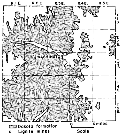
Clara-Throop mining district--Coal was mined 50 or more years ago on the Cupp farm now owned by Earl Pascal in the NE cor. SW sec. 17, T. 3 S., R. 2 E. The Cupp location is about 3 miles north and half a mile west of Throop. The coal as reported by Plummer (personal communication) was 18 inches thick although at the time of my visit to the place on July 29, 1947, only 4 to 6 inches of the coal was seen. Whether the coal seen was the seam mined or whether a second and thicker seam is present could not be ascertained as the coal observed was practically at creek level and the slopes above the coal were excessively slumped and soggy from springs. The coal is overlain by a sandstone and occurs in a dark-gray shale. Associated with the lignite were many pyrite nodules. A small amount of lignite was mined by stripping in the cen. NE sec. 20, T. 3 S., R. 1 E., along the bank of a small creek. This strip location is about 2 miles west and half a mile south of the Cupp mine or 3 miles north and half a mile east of Clara. The seam seen at this place measures 14 inches in thickness and occurs in a dark-gray shale. The same seam of lignite, also 14 inches thick, crops out in the creek bed in the NW cor. NE of the section. The overburden at both places is from 20 to 30 feet thick.
Production and reserves--No data were obtained in regard to how much lignite was mined in Washington County. It is reasonably certain, however, that production did not amount to much. All lignite reserves in Washington County consist of coals less than 30 inches in thickness, and therefore are classified here as marginal reserves. It is reasonably certain that 300,000 tons of lignite is available in sec. 24 and 400,000 tons in sec. 17, a total of 700,000 tons in the Clara-Throop area.
Ottawa County--Coal about 6 inches thick was discovered by a Mr. Gladden who lived on the headwaters of Hard Crossing Creek in about 1864 or 1865 (Scheffer, 1934, p. 234). Gladden took a sample of the coal to Junction City for the purpose of organizing a coal-prospecting company. Failing in his efforts to organize a coal company and endeavoring to keep the matter of coal before the public, Gladden was able to have the name of Hard Crossing Creek changed to Coal Creek, the name it still bears. Just where the coal was found is not certain. Coal Creek post office was established on October 3, 1866. Its location, however, is uncertain as on the Ottawa County map for 1875 (Gray, 1875, p. 367) Coal Creek post office is located in the SE sec. 23, T. 12 S., R. 2 W., whereas on the map for 1880 (Hudson, 1881, p. 60) Coal Creek post office is in the SE sec. 18, T. 12 S., R. 1 W. By 1887 Coal Creek post office no longer appeared on the Ottawa County map published by the Kansas State Board of Agriculture. The Ottawa County coal seam was not seen but judging from the geologic map of Kansas the coal must occur in the basal part of the Dakota formation which forms the bedrock for most of the county (Fig. 23). Mudge (1875, p. 125) also included Ottawa County among the Cretaceous lignite-bearing counties of central Kansas at an early date.
Figure 23--Map of Ottawa County, Kansas, showing distribution of the Dakota formation and the location of the Coal Creek post office of 1882.
Other counties containing lignite--Lignite has been reported also from Barton, McPherson, Rice, and Saline counties by Mudge as early as 1875 (p. 125) and from Barber County in 1887 by Hay (1889, p. 7) and is likewise reported to be present in Ford and Osborne counties (Moore, 1929, p. 4). Latta (1950, pp. 179-180) reports a 1-foot brown to black lignite in a test hole, drilled in 1945 at a depth of 98 feet below the surface and 61 feet below the top of the Dakota formation and thin beds of coal at a depth from 145 to 148 feet at the base of the Dakota formation in Barton County. The test hole is in the Cheyenne Bottoms (Schoewe, 1949, pp. 294-296) at the NE cor. sec. 9, T. 18 S., R. 13 W., less than a mile southeast of Hoisington. No coal was seen in any of the counties listed and with the possible exception of the northern part of Ford County (see discussion under Hodgeman County) no minable coal is believed to exist in those counties.
Abernathy, G. E. (1944) Mined areas of the Weir-Pittsburg coal bed: Kansas Geol. Survey, Bull. 52, pt. 5, pp. 213-228, fig. 1, pl. 1.
Abernathy, G. E. (1946) Strip-mined areas in the southeastern Kansas coal field: Kansas Geol. Survey, Bull. 64, pt. 4, pp. 125-144, fig. 1, pls. 1-3.
Abernathy, G. E., Jewett, J. M., and Schoewe, W. H. (1947) Coal reserves in Kansas: Kansas Geol. Survey, Bull. 70, pt. 1, pp. 1-20, figs. 1-2. [available online]
Anonymous (1951) Along the line of the Kansas Pacific Railway in western Kansas in 1870: Kansas Hist. Quart., May 1951, pp. 207-211.
Averitt, Paul, and Berryhill, L. R. (1950) Coal resources of the United States: U.S. Geol. Survey, Circ. 94, pp. 1-33, figs. 1-5. [available online]
Bailey, E. H. S. (1889) The composition of Kansas coals: Kansas Acad. Sci. Trans., vol. 11, pp. 46-49.
Blake, L. I. (1889) The evaporative power of Kansas coals: Kansas Acad. Sci. Trans., vol. 11, pp. 42-46.
Bowsher, A. L., and Jewett, J. M. (1943) Coal resources of the Douglas group in east-central Kansas: Kansas Geol. Survey, Bull. 46, pp. 1-94, figs. 1-12, pls. 1-6.
Brown, Bennett (1896) Eighth annual report of the Kansas State Inspector of Coal Mines, year ending December 1895, pp. 1-213.
Campbell, M. R. (1917) The coal fields of the United States, general introduction: U.S. Geol. Survey, Prof. Paper 100, pp. 1-33, figs. 1-3, pl. 1.
Casselman, D. R. (1903) Biennial report of the Inspector of Coal Mines, State of Kansas, for the two years ending December 31, 1902, pp. 1-86.
Charles, H. W. (1901) Dakota sandstone in Washington County: Kansas Acad. Sci. Trans., vol. 17, p. 194.
Crane, W. R. (1898) Special report on coal: Kansas Univ. Geol. Survey, vol. 3, pt. 2, pp. 107-336, figs. 4-54, pls. 31-70.
Crane, W. R. (1903) Coal fields of north-central Kansas: Mines and Minerals, vol. 24, p. 94.
Delplace, John (1941) Annual report of the Mine Inspection Division and the Mine Rescue Station for the year ending December 31, 1940, pp. 1-70.
Fieldner, A. C., Storch, H. H., and Hirst, L. L. (1944) Bureau of Mines research on the hydrogenation and liquefaction of coal and lignite: U.S. Bur. Mines, Tech. Paper 666, pp. 1-69, figs. 1-30.
Findley, G. W. (1888) State Inspector of Coal Mines, 3d Ann. Rept., pp. 1-68.
Fishel, V. C. (1948) Ground-water resources of Republic County and northern Cloud County, Kansas: Kansas Geol. Survey, Bull. 73, pp. 1-194, figs. 1-6, pls. 1-12. [available online]
Frye, J. C., and Brazil, J. J. (1943) Ground water in the oil-field areas of Ellis and Russell counties, Kansas: Kansas Geol. Survey, Bull. 50, pp. 1-104, figs. 1-9, pls. 1-2.
Gallagher, A. C. (1894) Sixth annual report of the State Inspector of Coal Mines for the year 1893, pp. 1-179.
Gould, C. N. (1901) The Dakota Cretaceous of Kansas and Nebraska: Kansas Acad. Sci. Trans., vol. 17, pp. 122-178, pls. 4-12.
Gray, Alfred (1874) Kansas State Board of Agriculture, 3d Ann. Rept., vol. 3, pp. 1-372.
Gray, Alfred (1875) Kansas State Board of Agriculture, 4th Ann. Rept., vol. 4, pp. 1-753.
Hay, Robert (1885) In the Dakotah: Kansas Acad. Sci. Trans., vol. 9, pp. 109-113.
Hay, Robert (1889) Horizons of the Dakotah lignite: Kansas Acad. Sci. Trans., vol. 11, pp. 5-8.
Hay, Robert (1890) A geological reconnaissance in southwestern Kansas: U.S. Geol. Survey, Bull. 57, pp. 1-49, figs. 1-21, pls. 1-2.
Hudson, J. K. (1881) Kansas State Board of Agriculture, 2d Bienn. Rept., pp. 1-640.
Hutchinson, C. C. (1871) Resources of Kansas: published privately by author, Topeka, pp. 1-287.
Jewett, J. M., and Schoewe, W. H. (1942) Kansas mineral resources for war-time industries: Kansas Geol. Survey, Bull. 41, pt. 3, pp. 69-180, figs. 1-13.
Landes, K. K. (1930) The geology of Mitchell and Osborne counties, Kansas: Kansas Geol. Survey, Bull. 16, pp. 1-55, fig. 1, pls. 1-15. [available online]
Landes, K. K. (1937) Mineral resources of Kansas counties: Kansas Geol. Survey, Min. Res. Circ. 6, pp. 1-102.
Latta, B. F. (1950) Geology and ground-water resources of Barton and Stafford counties, Kansas: Kansas Geol. Survey, Bull. 88, pp. 1-228, figs. 1-18, pls. 1-11. [available online]
Logan, W. N. (1897) The upper Cretaceous of Kansas in stratigraphy and general geology of western Kansas: Kansas Univ. Geol. Survey, vol. 2, pp. 195-234, figs. 10-11, pls. 5-6, 12, 24, 27-28, 30-34.
McGrath, G. T. (1898) Tenth Annual report of the Inspector of Coal Mines, State of Kansas, pp. 1-157.
McGrath, G. T. (1899) Eleventh annual report of the Inspector of Coal Mines, State of Kansas, pp. 1-51.
Moore, R. C. (1929) Kansas coal fields: U.S. Bur. Mines, Tech. Paper 445, pp. 3-7, figs. 1-2.
Moore, R. C., Frye, J. C., and Jewett, J. M. (1944) Tabular description of outcropping rocks in Kansas: Kansas Geol. Survey, Bull. 52, pt. 4, pp. 137-212, figs. 1-9.
Moore, R. C., and Landes, K. K. (1927) Underground resources of Kansas: Kansas Geol. Survey, Bull. 13, pp. 1-154, figs. 1-115.
Moore, R. C., and others (1951) The Kansas rock column: Kansas Geol. Survey, Bull. 89, pp. 1-132, figs. 1-52. [available online]
Mudge, B. F. (1866) First annual report on the geology of Kansas, pp. 1-56.
Mudge, B. F. (1875) Geology of Kansas: Kansas State Bd. of Agri., 4th Ann. Rept., pp. 107-127.
Plummer, Norman, and Romary, J. F. (1942) Stratigraphy of the pre-Greenhorn Cretaceous beds of Kansas: Kansas Geol. Survey, Bull. 41, pt. 9, pp. 313-348, figs. 1-4, pls. 1-2. [available online]
Plummer, Norman, and Romary, J. F. (1947) Kansas clay, Dakota formation: Kansas Geol. Survey, Bull. 67, pp. 1-241, figs. 1-17, pls. 1-7.
Rubey, W. W., and Bass, N. W. (1925) The geology of Russell County, Kansas: Kansas Geol. Survey, Bull. 10, pp. 1-104, figs. 1-11, pls. 1-7.
St. John, O. (1887) Notes on the geology of southwestern Kansas: Kansas State Bd. of Agri., 5th Bienn. Rept. pp. 132-152.
Saunders, W. H. (1873) Coals of Kansas: Kansas State Bd. of Agri., Trans. 1872, pp. 387-391.
Saunders, W. H. (1896) Coals of Kansas: Kansas Acad. Sci. Trans., vol. 1, pp. 30-34.
Scheffer, T. H. (1934) Geographical names in Ottawa County: Kansas Hist. Quart., vol. 3, pp. 227-245.
Schoewe, W. H. (1944) Coal resources of the Kansas City group, Thayer bed, in eastern Kansas: Kansas Geol. Survey, Bull. 52, pt. 3, pp. 81-136, figs. 1-8, pls. 1-5. [available online]
Schoewe, W. H. (1946) Coal resources of the Wabaunsee group in eastern Kansas: Kansas Geol. Survey, Bull. 63, pp. 1-144, figs. 1-35, pls. 1-5. [available online]
Schoewe, W. H. (1949) The geography of Kansas, Part 2, physical geography: Kansas Acad. Sci. Trans., vol. 52, no. 3, pp. 261-333, figs. 12-55.
Schoewe, W. H. (1951) Coal resources of the Permian System in Kansas: Kansas Geol. Survey, Bull. 90, pt. 3, pp. 53-68, figs. 1-4, pl. 1. [available online]
Sims, William (1883) Kansas State Board of Agriculture, 3d Bienn. Rept., pp. 1-715.
Stewart, J. T. (1891) State Inspector of Coal Mines, 4th Ann. Rept., pp. 1-116.
Stewart, J. T. (1892) Fifth report of the State Inspector of Coal Mines, pp. 1-86.
Twenhofel, W. H. (1924) The geology and invertebrate paleontology of the Comanchian and "Dakota" formations of Kansas: Kansas Geol. Survey, Bull. 9, pp. 1-135, pls. 1-23. [available online]
Whitla, R. E. (1940) Coal resources of Kansas: Post-Cherokee deposits: Kansas Geol. Survey, Bull. 32, pp. 1-64, figs. 1-28, pls. 1-5. [available online]
Wing, M. E. (1930) The geology of Cloud and Republic counties, Kansas: Kansas Geol. Survey, Bull. 15, pp. 1-51, figs. 1-2, pls. 1-18. [available online]
Young, C. M., and Allen, H. C. (1925) Kansas coal: Kansas Univ. Bull. 26, no. 5, Engr. Bull. 13, pp. 1-202, figs. 1-29, pls. 1-3.
Kansas Geological Survey, Coal Resources of the Cretaceous System
Placed on web Jan. 16, 2009; originally published in February 1952.
Comments to webadmin@kgs.ku.edu
The URL for this page is http://www.kgs.ku.edu/Publications/Bulletins/96_2/page2.html