Kansas Geological Survey, Bulletin 41, Part 9, originally published in 1942
Next--Stratigraphy
Ceramists for the State Geological Survey of Kansas.
Originally published in 1942 as Kansas Geological Survey Bulletin 41, Part 9. This online version has been created because the published version is currently out of print. This is, in general, the original text as published in 1942. The information has not been updated.
Field work undertaken primarily to determine the occurrence and ceramic properties of clay deposits in the pre-Greenhorn Cretaceous beds of central and north-central Kansas has resulted in much detailed stratigraphic information. The newly acquired data indicate needs for reclassification of these beds.
Numerous classifications have been proposed for the Cretaceous rocks of Kansas by various workers during the past 75 years. For the most part, the proposed formations have been either inadequately defined or have been of such non-persistent nature that they were not useful outside of the type area.
The classification proposed in this paper is as follows: The oldest Cretaceous rocks known in Kansas, which are of continental origin, are classed as the Cheyenne sandstone. Dark marine shale and sandstone above the Cheyenne sandstone are assigned to the Kiowa shale. These two stratigraphic units, named from Kiowa county, Kansas, have been recognized by workers for many years and can be correlated with beds in the north-central Kansas region.
Nonmarine clay and sandstone deposits that overlie the Kiowa shale are here designated as the Dakota formation. The Dakota is limited upward by the base of the Graneros shale. The formation is here subdivided into two members: the Terra Cotta clay member at the bottom and the Janssen clay member at the top. The marine shale above the Dakota formation and below the Greenhorn limestone is classified as the Graneros shale.
The continental or near-shore Cheyenne sandstone is thought to represent deposits made near the strand line of the northward-advancing Cretaceous sea. The Kiowa shale was deposited in a relatively shallow sea. The Dakota formation comprises clay and sand deposited on flats not far above sea level. Deposition of the Dakota beds was terminated by a re-advance of the sea, and in this sea the marine shale and sandstone of the Graneros formation accumulated.
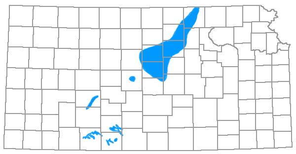
Rocks of Cretaceous age are exposed over large areas in central and north-central Kansas, in Kiowa, Clark, and Comanche counties of south-central Kansas, and at many places in the western part of the state (fig. 1). The stratigraphy of these deposits has been given considerable attention during the past 75 years, and nearly as many classifications of the beds have been proposed as the number of geologists who have investigated them. For the most part these studies have been rather superficial, although Twenhofel (1920, 1924) and others have described the marine fauna of the Kiowa shale in some detail. Many of the formations that have been named are either inadequately defined or they are of such lenticular or local nature that they have little value outside of the type areas. It is the purpose of this paper to present new data concerning the lithology and lateral extent of these beds, and to reclassify them in stratigraphic units that can be correlated over all of central Kansas.
Figure 1--Outline map showing outcrop area of pre-Greenhorn Cretaceous beds.
Field work was started by us in central and north-central Kansas in June 1938; and, since that time, 24 months have been spent in the field in this area. During this time the Cretaceous strata of eleven counties were studied in detail, and preliminary observations were made in three others (fig. 2). The original study was planned primarily as an investigation of the ceramic materials in the lower part of the Cretaceous system. In such an investigation it was necessary to obtain unweathered samples of the clay and shale deposits, and this was possible only in pits dug especially for that purpose. To facilitate such a sampling program, a W.P.A. project was set up and about 1,400 pits were dug. The samples were taken from these pits and the thickness of beds was measured in freshly made exposures. The pits were placed in off-setting position along selected slopes and were approximately 11 feet deep (fig. 3).
Figure 2--Index map of Kansas showing area covered by investigation.
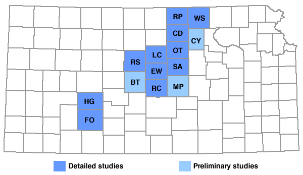
Figure 3--Diagram showing method of excavating the pits from which samples were obtained.

A sufficient number of samples were taken to obtain an adequate representation of all Cretaceous strata exposed below the base of the Greenhorn limestone. These samples were taken to the laboratory where ceramic tests and chemical analyses were made. The investigation of ceramic materials has furnished valuable stratigraphic information which is derived from accurately measured sections in areas where the beds are inadequately exposed by ordinary erosion agencies and from detailed studies in the field and laboratory on the lithology of the deposits. Basic stratigraphic data will be presented in considerable detail in a subsequent report on the ceramic properties of the clay.
The literature on the stratigraphy of the Cretaceous beds below the Greenhorn limestone in Kansas has been reviewed adequately by Tester (1931, pp. 204-230).
Acknowledgments--We are indebted to the Federal Work Projects Administration for supplying us with the laborers who excavated the pits from which our samples were taken and from which most of our sections were measured, and for the assistants who carried out "the routine ceramic tests in the laboratory. We express our thanks to R. C. Moore, K. K. Landes, and John C. Frye for direction and assistance in the field and in preparation of the manuscript, and to Dorothea Weingartner for editorial assistance. We are also grateful to E. D. Kinney and Raymond Thompson who have been responsible for the chemical analyses, and to William Hladik, who has supervised the laboratory crew in work on the clay samples. We also thank Ralph E. Grim, petrographer of the Geological Survey of Illinois, for his valuable assistance in identifying the clay minerals in the clays described in this report. It is fitting, also, to thank many individuals and several civic organizations, not separately enumerated, for cooperation and assistance given to us in the various counties where we worked. Particularly, we acknowledge the able assistance of Frank Mullen, farmer and self-trained geologist, of Ellsworth county.
Kansas Geological Survey, Geology
Placed on web October 2005; originally published November 30, 1942.
Comments to webadmin@kgs.ku.edu
The URL for this page is http://www.kgs.ku.edu/Publications/Bulletins/41_9/index.html