Prev Page--Paleozoic--Pennsylvanian System || Next Page--Bibliography
Pre-Pennsylvanian Rocks
[Note: The classification and nomenclature of the pre-Pennsylvanian rocks described in this report by Wallace Lee, although adopted by the State Geological Survey of Kansas, differ somewhat from usage in formal reports of the U. S. Geological Survey.]
Except for a small area of Mississippian rocks in the southern part of the State, the pre-Pennsylvanian rocks which crop out in the neighboring areas are known in Kansas only from cuttings, cores, and various kinds of records of drilled wells, supplemented by geophysical information. The present distribution of these rocks in the subsurface of Kansas is closely related to the pre-Pennsylvanian structural movements of the State and to subsequent periods of erosional beveling that stripped some of the formations from large areas where they occurred originally.
Regional relations--The pre-Pennsylvanian rocks of Kansas range in age from Pre-Cambrian to Mississippian. Their distribution, thickness, structural, and stratigraphic relations, and in considerable degree, their lithologic characters are reflections of earth movements which affected the Kansas region in Paleozoic geologic historv. The location and relationships of principal movements are shown diagrammatically in Figures 43 to 46.
Cambrian and Ordovician Arbuckle rocks were removed from the crest of the pre-St. Peter Southeast Nebraska arch, before deposition of the St. Peter sandstone (Ordovician) and they were in part removed from marginal areas, especially along the crest of the contemporaneous arch extending southward across Kansas. On the Chautauqua arch, the Arbuckle rocks were reduced in thickness and all formations older than the Chattanooga shale (?Devonian) were removed from its crest during periods of uplift and erosion that preceded the deposition of the Devonian rocks and again before the deposition of the Chattanooga shale. Middle and Late Ordovician, Silurian, and Devonian rocks were beveled on the northern flank of the Chautauqua arch in Kansas and on its southern flank in northeastern Oklahoma. The Chattanooga shale was deposited across this beveled surface and rests unconforniably on rocks from Arbuckle to Devonian. Downwarping of the North Kansas basin, which occurred contemporaneously with the rise of the Chautauqua arch, preserved greater thicknesses of Devonian, Silurian, and Late and Middle Ordovician rocks in that area than are known in odier parts of Kansas.
On the Central Kansas uplift, some formations were removed after the initial movements that occurred before Mississippian time. Greatly renewed activity of this structural feature occurred after Mississippian time and erosion of the uplifted area removed the whole sequence of Mississippian rocks and some additional older rocks from its crest before the beginning of Pennsylvanian deposition.
The Nemaha anticline, which was raised contemporaneously with the Central Kansas uplift, was also beveled with the removal of progressively greater thicknesses of rock toward the north and toward the south. In southern Kansas only the upper formations of the Mississippian were lost, but near the Nebraska line the whole sequence of pre-Pennsylvanian sedimentary rocks was eroded from the crest. Secondary anticlines, like the Voshell and Abilene anticlines and others, were similarly affected by post-Mississippian erosion but in minor degree.
On the other hand, in contemporaneously downwarped areas that became the Hugoton embayment, the Salina basin, and the Forest City basin (but not the Cherokee basin) greater thicknesses of pre-Pennsylvanian rocks were preserved below the level of erosion than in other areas.
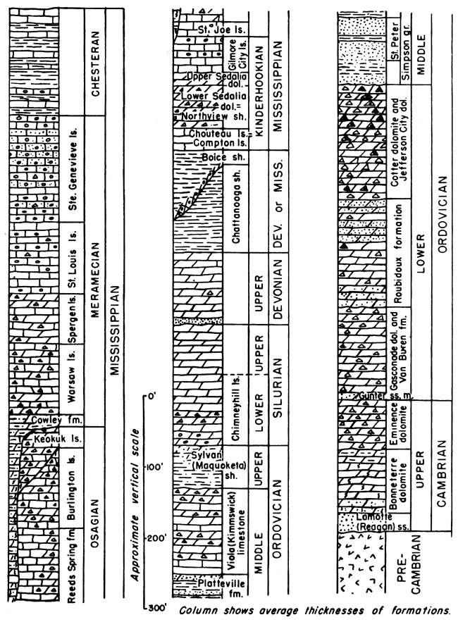
Figure 42--Pre-Pennsylvanian Paleozoic rocks in Kansas. Te complete sequence is present nowhere in Kansas.
Mississippian System
Mississippian rocks are found at the surface in Kansas only in a small area of less than two townships in Cherokee County, in the extreme southeastern corner of the State. In the subsurface, Mississippian rocks are present throughout the State except on the crest of the Central Kansas uplift and northern end and northwestern flank of the Nemaha anticline, from which Mississippian formations were stripped during uplift and erosion that preceded the deposition of Pennsylvanian rocks. The Mississippian rocks have a maximum thickness in the Hugoton embayment of southwestern Kansas where drilling has revealed more than 1,600 feet.
Chesteran Series
Important unconformities separate the Chesteran Series from Pennsylvanian rocks above and Meramecian beds below. White semigranular limestones of Batesville age, which crop out in northeastem Oklahoma above Keokuk limestone, extend into southeastern Kansas, where they have maximum thickness of less than 20 feet. In the subsurface of southwestern Kansas, Chesteran rocks are confined to deeper parts of the Hugoton embayment in Morton, Seward, Meade, Clark, and adjacent counties to the north, occurring at depths of 5,100 to 5,900 feet below the surface. They consist of granular and semigranular limestones, alternating irregularly with yellow, black, gray, and brown shale and marl. Thickness increases southward from a featheredge at the north, the total being 350 feet near the State line. Fossils from cores examined by M. K. Elias are correlated with upper, middle, and lower parts of the Illinois Chesteran sequence.
Meramecian Series
In southern Kansas, the Meramecian Series lies disconformably on deeply eroded Osagian rocks, but in northeastern Kansas this disconformity is obscure. The upper formations consist almost entirely of limestone, but lower formations contain interbedded dolomite or are mainly silty dolomite and dolomitic siltstone containing variably large quantities of chert. Meramecian rocks probably extended originally throughout Kansas but were eroded from most of the State before Pennsylvanian deposits were formed.
Ste. Genevieve limestone--Disconformable be!neath Chesteran but seemingly conformable on St. Louis limestone, the Ste. Genevieve underlies a small part of northeastern Kansas in the deeper part of the Forest City basin, but is widespread in the Hugoton embayment of southwestern Kansas. It consists mainly of silty and sandy white limestone interbedded with fine-textured oolitic limestone. The thickness is about 30 feet in Doniphan and Atchison counties, and 215 feet in the Hugoton embayment, where the formation maintains fairly constant thickness except as beveled by pre-Pennsylvanian erosion on the flanks of uplifted areas.
St. Louis limestone--Conformable with Meramecian rocks above and below, the St. Louis consists typically of noncherty lithographic and sublithographic limestone but also includes semigranular and oolitic limestone containing traces of translucent chert. Although restricted to basin areas, it is more widely distributed than the Ste. Genevieve but is absent in the Salina basin. Maximum thickness in the Forest City basin is about 50 feet and in the Hugoton embayment about 200 feet.
Spergen limestone--In northeastern Kansas the Spergen limestone consists mainly of noncherty or sparsely cherty sugary to silty dolomite interstratified with noncherty granular limestone, which in some places constitutes the greater part of the formation. The microfossiliferous chert resembles that in the conformably underlying Warsaw. The foraminifer Endothyra baileyi is commonly present in the granular limestones. In southwestern Kansas, the Spergen consists mainly of semigranular and granular limestone although it is in part dolomitic. Thickness of the Spergen is about 50 feet in the deepest part of the Salina basin, where it underlies Pennsylvanian rocks, and in the Forest City basin, where it underlies the St. Louis limestone. In the Hugotan embayment, it is about 100 feet thick.
Warsaw limestone--Composed mainly of semigranular limestone interlaminated with sugary dolomite, the Warsaw includes relatively large amounts of distinctive microfossiliferous chert. Insoluble residues of some dolomite beds are spongy masses of spicules. In southern Kansas, the Warsaw grades downward into the Cowley formation without break, but elsewhere it is obscurely unconformable on rocks of Keokuk or Burlington age. The formation is widespread in central parts of the Salina and Forest City basins and in the Hugoton embayment. It is 30 to 40 feet thick in the Forest City and Salina basins and 300 to 350 feet in the central part of the Hugoton embayment.
Cowley formation--Silty dolomite, dolomitic siltstone, and variably large amounts of dark microfossiliferous chert characterize the Cowley formation. Color of the beds ranges locally from gray to black. In southeastern Kansas, grains of glauconite are thinly disseminated throughout, but especially conspicuous in the basal 20 to 90 feet. In southwestern Kansas, chert is less abundant and glauconite is inconspicuous or absent in the basal beds. The formation was deposited in a basin eroded in older Mississippian rocks. Locally in southeastern Kansas, pre-Cowley valleys were cut through Chattanooga shale into upper Arbuckle beds. The upland north of the basin was only slightly dissected. When the basin became filled by silty Cowley sediments, the sea spread widely across the upland area and sedimentation represented by the subsurface Warsaw prevailed. In Kansas, the Cowley formation is restricted to an east-west belt 15 to 75 miles wide north of the Oklahoma border. Where the Cowley cuts out Chattanooga shale and rests on Arbuckle dolomite, it has a thickness of more than 300 feet.
Osagian Series
Formations of the Osagian Series consist of varied sequences of dolomite and limestone distinguished from one another mainly by characters of included cherts. The older Osagian formations are restricted to southern Kansas and are overlapped northward by younger formations. Basal Osagian rocks are separated from the underlying Kinderhookian by a low angular unconformity.
Keokuk limestone and Burlington limestone--Although lithologically distinct in some subsurface areas and divided by an important disconformity, the Keokuk and Burlington formations are not clearly separable in others. In southeastern Kansas, where the Burlington is absent, Keokuk beds are characterized by white tripolitic chert, siliceous limestone, and dolomite. Toward the north, limestone and dolomite of probable Burlington age, containing dense opaque white chert and varying amounts of quartz, underlie the Keokuk. Upper Keokuk rocks closely resemble some Burlington beds and where such deposits form a single sequence, they are not readily distinguishable. Near Wichita, where the Burlington consists of white semigranular limestone, it is differentiated from underlying limestone of Fern Glen age only by traces of quartz in the insoluble residues. The Keokuk and Burlington are not distinctly differentiated in southwestern Kansas although tripolitic silica occurs in some wells. The Keokuk and Burlington sequence of rocks is widely distributed in Kansas and formerly covered most, if not all, of the State. Pre-Pennsylvanian erosion beveled these strata, removing them from the Central Kansas uplift, the northern part of the Nemaha anticline, and country north of the Salina basin. In most areas, the Burlington seems to grade downward without break into Fern Glen deposits but at margins of basins, and especially toward the north in eastern Kansas, Burlington-Keokuk beds overlap onto pre-Osagian rocks. The combined thickness of the Keokuk and Burlington, where not trenched by pre-Cowley erosion, ranges from 170 feet or more in the south to about 100 feet in the north.
Reeds Spring formation and St. Joe limestone--Two formations of Fern Glen age are recognized at outcrops in southwestern Missouri and in ihe subsurface near the outcrops; the Reeds Spring formation above and the St. Joe limestone below. The Reeds Spring consists of buff and gray sugary dolomite with abundant dark to brown semitranslucent chalcedonic chert and parti-colored semiopaque chert. These rocks grade westward into gray interlaminated dolomite and limestone with gray and blue-gray chalcedonic semitranslucent chert and semiopaque chert. In southeastern Kansas, white semigranular and coarsely granular noncherty limestone beneath the Reeds Spring is classed as St. Joe limestone. In the Wichita area, St. Joe, Reeds Spring, and Burlington rocks are all semigranular almost pure limestone, the Reeds Spring division being identified by the presence of small amounts of chalcedonic chert in the insoluble residues. Rocks of Fern Glen age overlap on pre-Mississippian formations on the southeastern and southern flank of the contemporaneously rising Central Kansas uplift. In this area, reddish and greenish argillaceous limestone, mostly noncherty, and some calcareous red shale represent upper parts of the Fern Glen deposits, whereas the lower (St. Joe) part is dark gray and argillaceous. Farther westward, the lower beds include lithographic limestones. Rocks of Fern Glen age occur only in the southern part of the State. Both east and west of the Nemaha anticline and on the south flank of the Central Kansas uplift, the noncherty St. Joe limestone is overlapped toward the north by Reeds Spring, and this in turn by Burlington and by Keokuk. The upper part of the Fern Glen rocks (Reeds Spring), where overlain by Burlington in southern Kansas, has a maximum thickness of about 150 feet. It wedges out northward in Ottawa County on the west side of the Nemaha anticline and in Jackson County on the east side. The St. Joe limestone has maximum thickness of about 45 feet in southeastern Kansas, but farther west it is mostly less than 20 feet thick. The correlation of the St. Joe with beds in southwestern Kansas is uncertain.
Kinderhookian Series
A low angular unconformity separates the Kinderhookian Series from overlying Osagian rocks. All Kinderhookian formations thicken northward toward a basin in central Iowa, whereas the Osagian formations thicken southward.
Gilmore City limestone--Uppermost of the Kinderhookian deposits in Kansas is the Gilmore City limestone, which consists of noncherty, soft chalky limestone enclosing granules of broken calcareous fossils. In some zones, the granules are coated with algal crusts. Other zones are characterized by oolites, including some of irregular shape and black color. In western Kansas, the formation contains some chert. The Gilmore City limestone of Kansas occurs northeast and southwest of the Central Kansas uplift, lying disconformably on Sedalia dolomite. It thickens northwestward from a featheredge in Leavenworth County to 76 feet in Cloud County and westward from a featheredge in Finney County to 120 feet in Scott County, becoming thinner again farther northwest.
Sedalia dolomite--The upper part of the Sedalia dolomite consists of noncherty or sparsely cherty buff to gray dolomite, which extends from outcrops in Missouri westward to the northeastern flank of the Central Kansas uplift. It conformably overlies lower Sedalia east of the Nemaha anticline, but overlaps upon the Chattanooga shale to the west. In Kansas, the upper member has a maximum thickness of 30 feet near Kansas City but is rarely more than 10 feet thick west of the Nemaha anticline, where it occurs in local outliers beneath Gilmore City limestone or Fern Glen rocks, as in McPherson and adjoining counties. The chert of the lower member is generally ash gray and characterized by somewhat unique stippled markings. Southward, it thins and wedges out near the Oklahoma border. In southeastern Kansas lower Sedalia dolomite is equal to Northview shale.
Compton limestone--The Compton limestone of Chouteau age is the lowest limestone formation of the Kinderhookian Series. It closely resembles the St. Joe limestone in southeastern Kansas but is slightly greenish-gray and less granular. Like the lower member of the Sedalia, it lies entirely east of the Nemaha anticline. The Compton ranges in thickness from a featheredge east of the Nemaha anticline and at the Oklahoma border in southeastern Kansas to about 45 feet near Kansas City.
Mississippian or Devonian System
The shale sequence between Mississippian and Devonian limestones in northeastern Kansas is divided into two formations; Boice shale above and Chattanooga shale below. They are separated by a marked disconformity with topographic relief locally of as much as 110 feet. It is probable, although not proved, that the Boice shale is of Mississippian age and the Chattanooga shale (often miscalled "Kinderhook" shale) is of Devonian age.
Boice shale--Dark or light greenish-gray spore-bearing silty or dolomitic shale and basal beds of red shale or ferruginous oolite of variable thickness comprise the Boice shale. These strata conformably underlie Compton limestone or occur disconformably beneath upper Sedalia. They lie disconformably on deeply eroded Chattanooga. The Boice shale is confined to northeastern Kansas but extends somewhat west of the Nemaha anticline. Its maximum known thickness is 110 feet near the Nebraska border in Brown County.
Chattanooga shale--The Chattanooga shale is silty, pyritiferous, and in some places partly dolomitic. Spores are thinly disseminated throughout but most common in basal beds. The shale is black in southern Kansas but northward it grades into gray shale. The Misener sandstone member at the base of the shale is a distinct unit in some places but in most of eastern Kansas it is represented only by disseminated rounded sand grains. The Chattanooga shale is separated from underlying rocks by a low angular unconformity. From north to south, the Chattanooga overlaps on beveled older rocks ranging in age from Devonian to Middle Ordovician. It is present in most of eastern and central Kansas, but absent at the northern end of the Nemaha anticline, in the area northwest and northeast of the Salina basin, on the Central Kansas uplift, and southwest of the uplift. It extends in a continuous sheet westward along the Oklahoma border to Clark County in the south and Osborne County in the north. Its thickness ranges from a featheredge in Osborne, Clark, and intermediate counties to more than 250 feet in northeastern Kansas near the Nebraska border. Abnormal thicknesses of Chattanooga shale occur in McPherson County and areas to the east where the formation was deposited in valleys eroded in the older rocks.
Devonian System
Limestones and dolomites of Devonian age commonly are included with Silurian rocks in a subsurface unit called "Hunton limestone." The Devonian rocks of east-central Kansas consist of relatively pure lithographic and sublithographic limestones that grade northwestward into dolomite in the North Kansas basin. In some places, particularly just east of the Nemaha anticline, the Devonian is very coarsely crystalline and porous. A cherty zone commonly occurs 30 to 100 feet above the base. Basal Devonian beds, consisting of sandy dolomite or limestone, are distinguished readily from the nonsandy Silurian. An unconformity which occurs at the base of the Devonian section is one of the most important in the geologic sequence of Kansas, for it represents local pre-Devonian erosion of Silurian and older rocks hundreds of feet thick. In eastern Kansas, the Devonian successively overlaps Silurian, Sylvan, Viola, and upper Arbuckle rocks from north to south. Devonian limestones which once crossed the Chautauqua arch into Oklahoma were destroyed by pre-Chattanooga erosion. Devonian rocks now are confined to eastern Kansas where they occur flanking the Central Kansas uplift and Chautauqua arch. They are absent in the Hugoton embayment. In northeastern Kansas the maximum known thickness of the Devonian limestones and dolomites (215 feet) occurs in Nemaha County.
Figure 43--Pre-Simpson (pre-St. Peter) structural features in Kansas. Shown in eastern Kansas by the thickness of the earlier Paleozoic formations beveled by the Simpson (St. Peter). Lower Ordovician and Upper Cambrian rocks absent on crest of the Southeast Nebraska arch; its southern extension shown by 200-foot thickness contours. In southeastern Kansas the pre-Simpson thickness of the Arbuckle dolomites was later reduced by pre-Chattanooga erosion.
Figure 44--Structural features developed in Kansas between Simpson time and Mississippian time. North Kansas basin outlined by the 400-foot thickness contour (base of Simpson to base of Mississippian rocks). Farly movement of Central Kansas uplift outlined by assumed pre-Mississippian border of Viola limestone. Central area of ancestral Hugoton embayment shown by 150-foot Viola limestone thickness contour. Chautauqua arch outlined by pre-Chattanooga outcrop of base of Simpson.
Figure 45--Post-Mississippian-pre-Mesozoic structural features in Kansas. Central Kansas uplift outlined by margin of Mississippian rocks; Forest City and Cherokee basins by the generalized 750-foot thickness contour of Desmoinesian rocks; and central Salina basin by 300-foot thickness contour of Desmoinesian rocks. Nemaha anticline is shown by the trend of its axis. Central part of pre-Pennsylvanian Hugoton basin shown by approximate margin of Chesteran rocks.
Figure 46--Post-Permian structural features in Kansas. Western Kansas basin, evolved from Hugoton embayment, shown by generalized 250-foot structure contours on the Stone Corral. This basin is now the result of post-Dakota movements that tilted the Hugoton embayment northward toward a large basin in western Nebraska.
Figure 47--Distribution of pre-Simpson rocks in Kansas. Lower Ordovician or Upper Cambrian rocks or both underlie all of Kansas except in areas where removed by erosion. Some areas of pre-Simpson Pre-Cambrian outcrop are not shown.
Figure 48--Distribution of Simpson, Viola, and Sylvan (Maquoketa) rocks in Kansas. Separation of Sylvan areas in McPherson and Marion counties reveals a pre-Chattanooga valley. Nemaha anticline, A, pre-Pennsylvanian erosion removed pre-Pennsylvanian rocks from crest and beveled Pre-Cambrian to Devonian rocks on both flanks. Southern Nemaha anticline, B, pre-Pennsylvanian erosion exposed Pre-Cambrian rocks on local domes and beveled younger rocks (not shown) on their flanks. Chautauqua arch, C, pre-Chattanooga erosion removed upper part of Arbuckle group. Central Kansas uplift, D, pre-Pennsylvanian beveling exposed Lower Ordovician and Upper Cambrian rocks. Pre-Cambrian rocks exposed locally on anticlines; Simpson inliers preserved in synclines.
Figure 49--Distribution of "Hunton" (Devonian and Silurian) rocks in Kansas. Devonian unconformably overlaps older rocks from Arbuckle to Silurian. Re-entrant in McPherson and Marion Counties outlines pre-Chattanooga valley. Distribution of Devonian and older rocks on crest of Nemaha anticline (Morris and Wabaunsee counties) not yet revealed.
Figure 50--Distribution of Chattanooga and Mississippian rocks in Kansas. In parts of Barber and Comanche counties and southeastern and north-central Kansas, Mississippian limestones overlap margin of the shale. Chattanooga unconformably overlaps rocks from Arbuckle to Devonian. On Nemaha anticline, A, pre-Pennsylvanian erosion removed Mississippian and locally older rocks. On local domes on west flank Nemaha anticline, B, only Mississippian was eroded. On Central Kansas uplift, C, pre-Pennsylvanian erosion removed the Mississippian limestones. Outliers of Chattanooga shale occur in Ellsworth County and elsewhere.
Silurian System
Lack of sand grains mainly distinguishes the Silurian rocks of Kansas from the Devonian. Dolomite predominates but on the margin of the North Kansas basin some limestone is interbedded. The lower part of the Silurian, of probable Chimneyhill age, includes dolomitic oolite at the base, overlain by beds containing opaque white chert and slightly silty dolomite with sparsely distributed siliceous foraminifers. Higher strata are mostly white coarse dolomite. The Silurian rests disconformably on Sylvan (Maquoketa) shale, but without marked relief. In Kansas, the Silurian is restricted to the ancient North Kansas basin northeast of the Central Kansas uplift and north of the Chautauqua arch. Maximum thickness of the system in Kansas is 435 feet in Nemaha County.
Ordovician System
Late Ordovician rocks are represented in Kansas by the Sylvan (Maquoketa) shale. Middle Ordovician deposits include the Viola (Kimmswick) limestone and dolomite and Platteville formation (the latter being equivalent to the upper part of the Simpson group of Oklahoma). Early Ordovician rocks include the St. Peter sandstone and slightly older rocks of Simpson age, and formations referred to the "Arbuckle group."
Sylvan (Maquoketa) shale--The characteristic Sylvan shale of northeastern Kansas consists of greenish-gray silty dolomitic shale or cherty silty dolomite. In southern Kansas, the Sylvan becomes more argillaceous and less cherty and dolomitic. An obscure low angular unconformity between the Sylvan shale and the underlying Viola is revealed by the overlap, toward the southwest, of the Sylvan upon progressively older zones of the Viola. Like the overlying Silurian and Devonian rocks the Sylvan is now restricted principally to the area that once formed the North Kansas basin. It was originally continuous with areas of Sylvan shale in Oklahoma, but connection across the Chautauqua arch was broken by pre-Devonian and pre-Chattanooga beveling. The Sylvan is not recognized in southwestern Kansas. In eastern Kansas, where it occurs beneath the Silurian rocks, the Sylvan ranges from 155 feet in the north to less than 40 feet in the south.
Viola limestone--The Viola limestone of Kansas, which represents only part of the Viola of Oklahoma, consists of dolomite and limestone containing some cherty beds characterized by black flecks and spicular and tubelike fragments of microorganisms. In deep parts of the North Kansas basin, the carbonate rocks of the Viola are almost entirely dolomite, but toward margins of the basin earthy and granular limestone appears, especially at the base. An unconformity between Viola and Platteville rocks in Kansas is revealed by northward thickening of the Platteville formation. The Viola occurs throughout the State except on the Central Kansas uplift, Chautauqua arch, and northern end of the Nemaha anticline. In the Hugoton embayment it is overlain by Mississippian limestone. In eastern Kansas the Viola is 310 feet thick (Washington County), and it thins southward to 20 feet in Harvey County. In southwestern Kansas it thickens from a beveled edge on the flanks of the Central Kansas uplift to more than 200 feet in the deepest part of the Hugoton embayment at the State line.
Figure 43--Pre-Simpson (pre-St. Peter) structural features in Kansas. Shown in eastern Kansas by the thickness of the earlier Paleozoic formations beveled by the Simpson (St. Peter). Lower Ordovician and Upper Cambrian rocks absent on crest of the Southeast Nebraska arch; its southern extension shown by 200-foot thickness contours. In southeastern Kansas the pre-Simpson thickness of the Arbuckle dolomites was later reduced by pre-Chattanooga erosion.
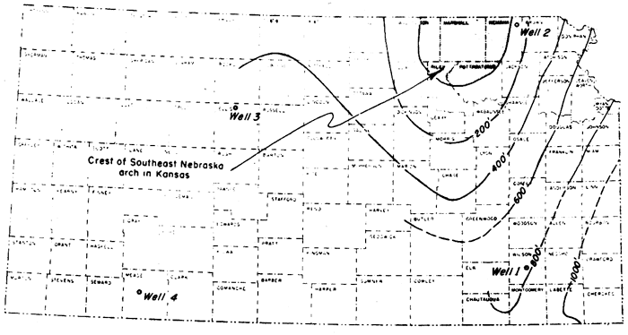
Figure 44--Structural features developed in Kansas between Simpson time and Mississippian time. North Kansas basin outlined by the 400-foot thickness contour (base of Simpson to base of Mississippian rocks). Early movement of Central Kansas uplift outlined by assumed pre-Mississippian border of Viola limestone thickness contour. Chautauqua arch outlined by pre-Chattanooga outcrop of base of Simpson.
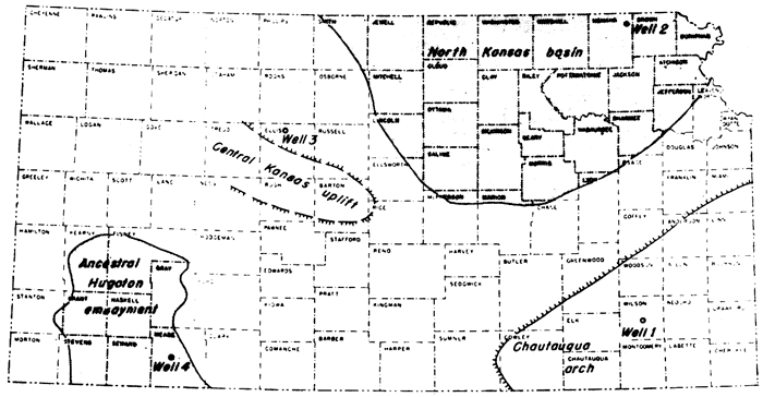
Figure 45--Post-Mississippian-pre-Mesozoic structural features in Kansas. Central Kansas uplift outlined by margin of Mississippian rocks; Forest City and Cherokee basins by the generalized 750-foot thickness contour of Desmoinsesian rocks; and central Salina basin by 300-foot thickness contour of Desmoinsesian rocks. Nemaha anticline is shown by the trend of its axis. Central part of pre-Pennsylvanian Hugoton basin is shown by approximate margin of Chesteran rocks.
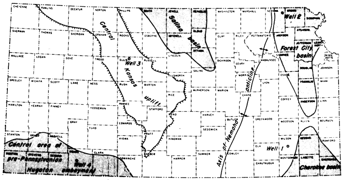
Figure 46--Post-Permian structural features in Kansas. Western Kasas basin, evolved from Hugoton embayment, shown by generalized 250-foot structure contours on the Stone Corral. This basin is now the result of post-Dakota movements that tilted the Hugoton Embayment northward toward a large basn in western Nebraska.
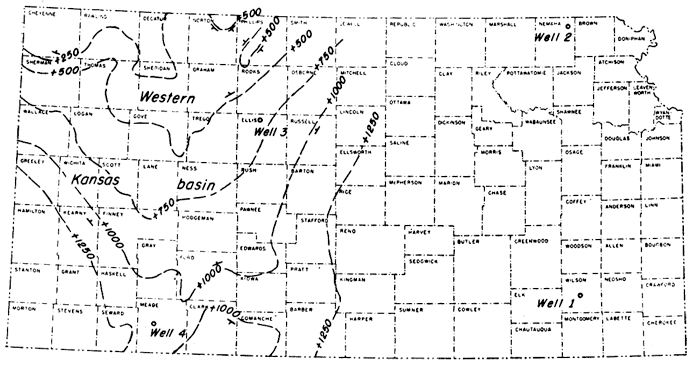
Figure 47--Distribution of pre-Simpson rocks in Kansas. Lower Ordovician or Upper Cambrian rocks or both underlie all of Kansas except in areas where removed by erosion. Some areas of pre-Simpson Pre-Cambrian outcrop are not shown.
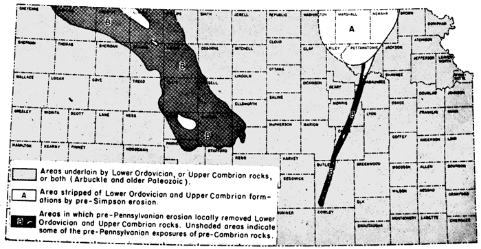
Figure 48--Distribution of Simpson, Viola, and Sylvan (Maquoketa) rocks in Kansas. Separation of Sylvan Areas in McPherson and Marion counties reveals a pre-Chattanooga valley. Nemaha anticline, A, pre-Pennsylvanian erosion removed pre-Pennsylvanian rocks from crest and beveled Pre-Cambrian to Devonian rocks on both flanks. Southern Nemaha anticline, B, pre-Pennsylvanian erosion exposed Pre-Cambrian rocks on local domes and beveled younger rocks (not shown) on their flanks. Chautauqua arch, C, pre-Chattanooga erosion removed upper part of Arbuckle group. Central Kansas uplift, D, pre-Pennsylvanian beveling exposed Lower Ordovician and Upper Cambrian rocks. Pre-Cambrian rocks exposed locally on anticlines; Simpson inliers preserved in synclines
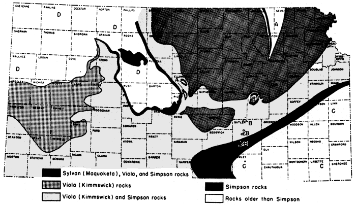
Figure 49--Distribution of "Hunton" (Devonian and Silurian) rocks in Kansas. Devonian unconformably overlaps older rocks from Arbuckle to Silurian. Re-entrant in McPherson and Marion counties outlines pre-Chattanooga valley. Distribution of Devonian and older rocks on crest of Nemaha anticline (Morris and Wabaunsee counties) not yet revealed.
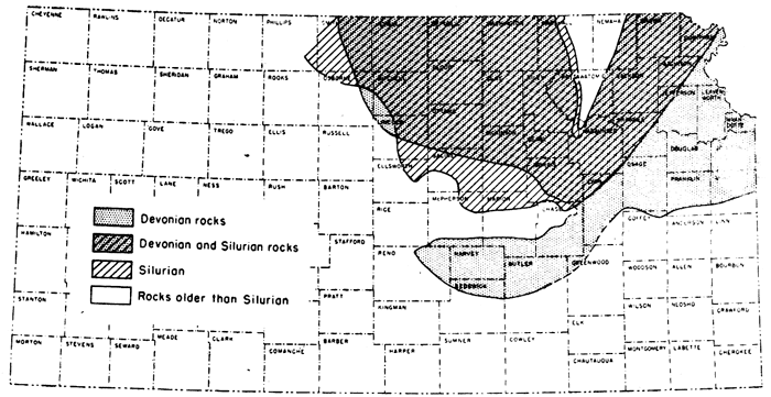
Figure 50--Distribution of Chattanooga and Mississippian rocks in Kansas. In parts of Barber and Comanche counties and southeastern and north-central Kansas, Mississippian limestones overlap margin of the shale. Chattanooga unconformably overlaps rocks from Arbuckle to Devonian. On Nemaha anticline, A, pre-Pennsylvanian erosion removed Mississippian and locally older rocks. On local domes on west flank Nemaha anticline, B, only Mississippian was eroded. On Central Kansas uplift, C, pre-Pennsylvanian erosion removed the Mississippian limestones. Outliers of Chattanooga shale occur in Ellsworth County and elsewhere.
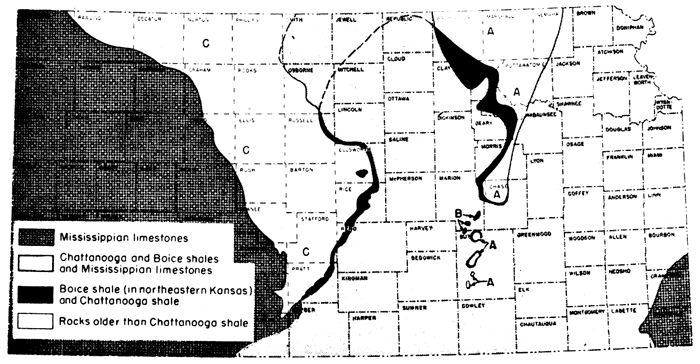
Figure 51--Selected sample study logs.
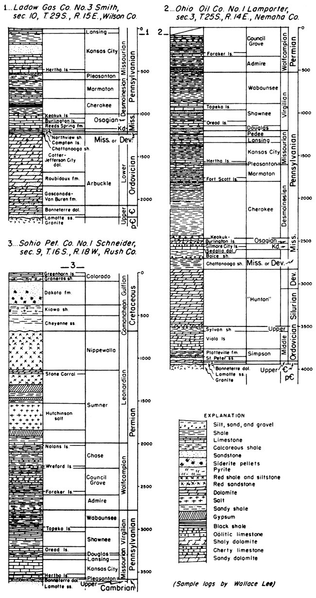
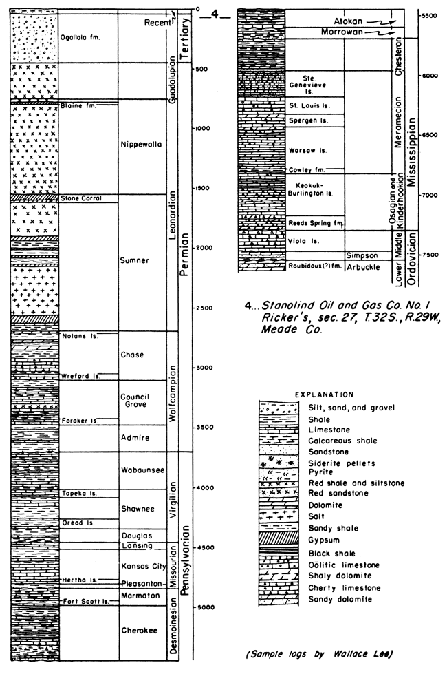
Figure 52--Selected sample study log.
Simpson group
The Simpson rocks of Kansas include the Platteville formation, of Middle Ordovician age, and the St. Peter sandstone and slightly older rocks of Early Ordovician age.
Platteville formation--Upper beds of the Platteville formation in Kansas consist of dolomite, limestone, sandstone, and green shale in varied succession, and at the basal part is a persistent dolomite. Some sand generally occurs in the basal dolomite and disseminated in the shales and dolomites of the upper part. In Kansas, the formation is restricted to the North Kansas basin. The Platteville is obscurely unconformable on the St. Peter sandstone in northeastern Kansas, where formations whose thickness aggregates about 900 feet at southeastern Missouri outcrops are missing. Maximum known thickness of the formation in Kansas is 100 feet in Brown County, from which it wedges out southward on the flanks of the Chautauqua arch and the Central Kansas uplift.
St. Peter sandstone and lower Simpson beds--The St. Peter sandstone and underlying green shale and sandstone, which occur near the Oklahoma border, are part of the Simpson group. A shaly zone in the middle part of the St. Peter in northeastern Kansas becomes more prominent southward, and westward near the Oklahoma border upper St. Peter sandstone is underlain by light-green and dark-green clay shale, sandy clay, and sandstone. In the Hugoton embayment, the Simpson is represented by sandy dolomite, white dolomitic sandstone, and blue-green to gray plastic shale. The sandstones are glauconitic. Rocks of Simpson age were formerly present throughout eastern and central Kansas, but pre-Devonian and pre-Chattanooga erosion removed them from the Chautauqua arch, and pre-Pennsylvanian and pre-Mississippian erosion removed them from considerable areas on the Central Kansas uplift and northern end of the Nemaha anticline. A low angular unconformity separates the St. Peter and associated Simpson beds from underlying rocks. The St. Peter overlies Pre-Cambrian and Upper Cambrian rocks on the Nebraska arch in northeastern Kansas and in outward directions overlaps on progressively younger Lower Ordovician rocks. The thickness of the St. Peter sandstone averages about 50 feet in northeastern Kansas. The St. Peter and associated Simpson rocks increase in thickness to 190 feet near the Oklahoma line. In the Hugoton embayment the Simpson is about 90 feet thick and thins to the north and west.
Arbuckle group
The Arbuckle group consists of Early Ordovician and Late Cambrian deposits, its subdivisions in Kansas being units that crop out in Missouri: Cotter and Jefferson City dolomites, Roubidoux formation, Gasconade dolomite, Van Buren formation, and Eminence dolomite. The Eminence is Cambrian and the others Ordovician.
Cotter and Jefferson City dolomites--Because dolomitic rocks representing the Cotter and Jefferson City dolomites of outcrops are not distinctly separable on lithologic criteria, they are classed together in the subsurface. They consist mainly of coarsely granular cherty dolomite. The upper part of the sequence includes much oolitic chert which becomes white and decreases in volume toward the base where white tripolitic chert becomes abundant. These rocks unconformably underlie various formations, such as St. Peter sandstone on the flank of the Southeast Nebraska arch, Chattanooga shale on the Chautauqua arch, and Pennsylvanian rocks on parts of the Central Kansas uplift and Nemaha anticline. The Jefferson City dolomite probably is conformable on Roubidoux formation. The Cotter-Jefferson City sequence ranges in thickness from a featheredge in northern Kansas to more than 650 feet in Cowley County
Roubidoux formation--In Kansas, this formation consists mainly of sandy dolomite; fine-grained sand with some secondary enlargement is irregularly distributed throughout. Deposition of the Roubidoux seems to have been preceded by warping and erosion of older rocks, Thickness of the formation generally ranges from 150 to 200 feet.
Gasconade dolomite and Van Buren formation--Deposits in Kansas which correspond to the Gasconade and Van Buren formations at outcrops in Missouri are not clearly separable in the subsurface. They consist mainly of very cherty coarse granular dolomite. The chert in the upper part, which is dense and gray to dark bluish, grades downward to white dense and quartzose chert. Like the Roubidoux, the Gunter sandstone member at the base of the Van Buren formation is a sandy dolomite in Kansas. The Van Buren formation is unconformable on Eminence beds and probably also Bonneterre, Lamotte, and Pre-Cambrian. The Proctor dolomite of Missouri is not recognized in the Kansas section. Gasconade-Van Buren rocks are reported in the subsurface in a belt along the Missouri state line. Their thickness ranges from a beveled edge to more than 200 feet in southeastern Kansas.
Cambrian System
Three Late Cambrian formations of Missouri are encountered in the subsurface of Kansas. The youngest of these (Eminence dolomite) is included in the Arbuckle group. Underlying rocks include the Bonneterre dolomite, equivalent to Honey Creek limestone in Oklahoma, and Lamotte sandstone, equivalent to Reagan sandstone in Oklahoma.
Eminence dolomite--Very cherty buff to white very coarsely crystalline dolomite is included in the Eminence dolomite. Vitreous semitranslucent chert contains cavities incrusted by fine crystalline quartz. The chert commonly is mixed so intimately with the dolomite that insoluble residues consist largely of chert with lacelike interconnecting molds of dolomite crystals. A low angular unconformity separates the Eminence from Bonneterre. Occurrence of Eminence deposits in eastern Kansas is confined mostly to a belt three counties wide bordering Missouri, but it is recognized also in western Kansas. The formation thickens eastward from a beveled edge to more than 150 feet at the Missouri line. Thicknesses of 40 to 87 feet are reported in west-central Kansas.
Bonneterre dolomite--The Bonneterre is a conspicuously glauconitic, noncherty dolomite which is dark gray to brown and finely crystalline in eastern Kansas and buff to white and coarsely crystalline in western Kansas. It includes sandy and silty dolomites, and dolomitic shale locally near the top. The Bonneterre is distributed throughout Kansas except on parts of uplifts such as the Southeast Nebraska arch, Central Kansas uplift, and Nemaha anticline. The Bonneterre grades downward into the Lamotte sandstone with which it is conformable. The thickness ranges from a beveled edge at margins of some uplifts to 150 feet in basin areas where it underlies the Eminence in eastern and western Kansas and locally in McPherson County.
Lamotte sandstone--The sand grains composing the Lamotte are ill sorted, rounded to angular, and coarse to fine. Arkosic material occurs in the lower part adjacent to Pre-Cambrian rocks. The Lamotte sandstone was deposited unconformably on a complex of Pre-Cambrian rocks which formed an uneven surface of very low relief. The formation is widespread in Kansas beneath the Bonneterre but locally Bonneterre overlaps on the Pre-Cambrian surface. Thicknesses of 80 to 130 feet have been reported in southeastern Kansas but the average thickness is about 20 feet.
Pre-Cambrian Rocks
Rocks of Pre-Cambrian age underlie all of Kansas. They include granite, porphyry, gneiss, schist, quartzite, slate, and marble, according to reports of deep wells. Granite or gneiss probably is most widespread.
Prev Page--Paleozoic--Pennsylvanian System || Next Page--Bibliography
Kansas Geological Survey, Geology
Placed on web Oct. 28, 2008; originally published Jan. 1951.
Comments to webadmin@kgs.ku.edu
The URL for this page is http://www.kgs.ku.edu/Publications/Bulletins/89/07_penn.html