![]()
Prev Page--Introduction || Next Page--Mesozoic
Cenozoic Rocks
Formations belonging to the Cenozoic Era, last of first-rank geologic time divisions, are widespread in Kansas. They comprise Quaternary sediments, which include glacial deposits of northeastern Kansas and nonglacial deposits of Pleistocene time in all parts of the State, and Tertiary deposits, which cover most of western Kansas.
Distribution and structure--Deposits of Cenozoic age occurring in Kansas constitute a discontinuous thin veneer which broadly conforms to the east-sloping land surface. Excepting the widespread Tertiary deposits of western Kansas, the Cenozoic sefimentary units are so patchy and irregular that they may hardly be said to exhibit regional structure.
Quaternary System
Character and surface distribution--Deposits of Quaternary age occur widely over Kansas. These are all non-marine in origin and include glacial, fluvial, and eolian deposits. Glacial sediments occur only in northeastern Kansas, whereas stream-laid and wind-borne deposits occur generally in the western half of the State and along valleys in the eastern half. As much as 400 feet of Quaternary deposits has been penetrated in drilling, and maximum thickness of the several units aggregates nearly 1,000 feet. Massive eolian silts (loess) are the most widespread Quaternary deposits in Kansas and form the immediate surface materials over approximately one-half of the area of the State. Much of the fertile top soil of Kansas is made from Quaternary alluvium and loess.
Subsurface features--The Quaternary System includes the youngest rocks of the State and is therefore the near-surface material. However, several features are revealed by the drill which are not apparent from surface observations. Chief among these are the abandoned filled valleys in areas where the surface topography is relatively flat; these include McPherson Valley and Wilson Valley of central Kansas, an extensive network of filled valleys in Rice County and under the Great Bend sand dune tract, and the glacially covered valley through Marshall, Nemaha, Jackson, and Atchison counties in northeastern Kansas,
Pleistocene Series
The distinctive sedimentary deposits formed in Pleistocene time, which comprises all of the Quaternary System, are glacial materials. Some glacial deposits, both those formed directly by ice work and those resulting from action of melt water derived from ice sheets, occur in Kansas, but they belong to the early and middle part of the Pleistocene Epoch. Outside the glaciated area of early Pleistocene time and throughout the State during the latter part of the Pleistocene Epoch, conditions resembled those of recent time.
Figure 3--Distribution of eolian Pleistocene deposits.
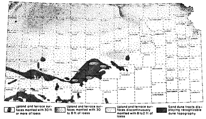
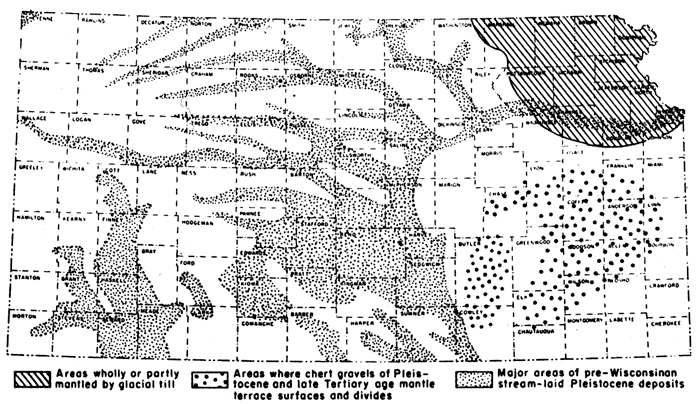
Figure 4--Distribution of noneolian Pleistocene deposits.
Recent Stage (including some undifferentiated Wisconsinan deposits)
Sedimentary deposits formed since the time of disappearance of the last glacial ice sheet from North America are classed as belonging to the Recent Stage. They are chiefly stream-laid deposits in continental areas such as Kansas, but on borders of continents they include marine sediments. Inasmuch as the last ice sheet (Wisconsinan) did not reach Kansas and conditions that are typical of Recent time began in this region approximately in mid-Pleistocene time, the Wisconsinan-Recent boundary in Kansas is not clearly recognizable at many places.
Alluvium--Gravel, sand, silt, and loam; gray to tan; underlies the valley flat of most stream valleys through the State. In western Kansas and along the through valleys of central and eastern Kansas the alluvium consists of sediments derived from the Rocky Mountain region mixed with local materials. In northeastern Kansas the alluvium is largely derived from glacial deposits; in southeastern Kansas it consists predominantly of chert gravel and sand and other material derived from the Paleozoic rocks of the region. Alluvium is generally thicker under major valleys and ranges in thickness from a few feet to more than 80 feet. Between Hutchinson and Wichita the alluvium of the Arkansas River Valley attains a known thickness of 275 feet.
Dune sand--Eolian sand, well-sorted, predominantly quartz; gray to tan; mantles the surface of much of central and southwestern Kansas, especially in the Great Bend area, south of Arkansas River. The dune sand in many areas represents several cycles of dune development. The younger cycles are Recent in age and consist of loose sand, whereas the older cycles are Wisconsinan to Illinoian in age and in some places are red brown and are partly indurated. Maximum thickness, about 50 feet.
Terrace deposits--Gravel, sand, silt, and clay; underlies low terrace surfaces in many valleys in all parts of the State. Recent to Wisconsinan in age. South of Kansas River Valley and east of the Flint Hills, terrace deposits are predominantly chert gravels. Thickness as much as 100 feet, commonly 30 feet.
Wisconsinan, Sangamonian, and Illinoian Stages
During Wisconsinan and Illinoian time continental glaciers advanced into states adjacent to Kansas but lacked by several hundred miles reaching the limits of Kansas. Eolian silt (loess) was deposited widely over the State, sand dune formation was active in the southwestern and south-central areas, and streams built extensive fills in many places. Important changes in major drainage lines occurred during this time and the Sangamonian and Bradyan (mid-Wisconsinan) intervals were times of extensive soil formation.
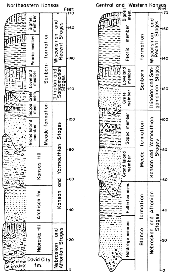
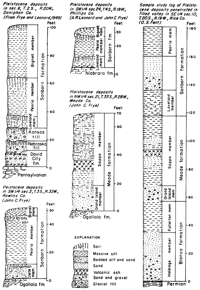
Sanborn formation--Massive silt, soil, sand, and gravel; widely distributed in northern and western Kansas. Sand and gravel are stream deposits, and widespread loess mantles extensive upland areas. Locally 200 feet thick, commonly 40 feet.
Bignell silt member--Massive eolian silt; forms a discontinuous upland mantle in northwestern Kansas and along Missouri River Valley. Mankatoan and Caryan in age. Thickness 35 feet in Doniphan County, commonly 8 feet.
Peoria silt member--Massive eolian silt, tan; widely distributed over the uplands of western, north-central, and extreme northeastern Kansas. Iowan and Tazewellian in age. The buried Brady soil, formed in pre-Bignell (Bradyan) time, occurs at the top of the Peoria silt. In some valley areas, unnamed water-laid sand and gravel occurs gradationally at the base of the silts. Exceeds 100 feet in thickness in Cheyenne and Doniphan counties, commonly 30 feet.
Loveland silt member--Massive silt and sandy silt, reddish-tan; in part eolian. Thick, prominent, buried Sangamon soil, formed in pre-Peoria (Sangamonian) time, occurs at the top of the Loveland silt. Illinoian and early Sangamonian in age. Thickness as much as 50 feet, commonly 20 feet.
Crete sand and gravel member--Sand, gravel, and silt, in terrace position along some valleys; locally grades upward into Loveland silt member; in southeastern Kansas predominantly chert gravels. Illinoian in age. Commonly 50 feet thick.
Figure 5--Pleistocene rocks in Kansas.
Yarmouthian and Kansan Stages
Deposition during Kansan time was largely influenced by Kansan glaciation. This ice sheet extended more than 100 miles into the State and glacial till occurs widely in the northeastern area. Some silt, sand, and gravel were deposited during the advance of this ice sheet, and during the time of its retreat they were deposited widely over the State as valley fillings. Some loess was deposited during late Kansan time but is now preserved at only a few places. In the area south of Kansas River Valley and east of the Flint Hills, Kansan deposits consist predominantly of chert gravels with some sand and silt, and occur as terraces along the major valleys. A fall of petrographically distinct volcanic ash occurred in latest Kansan time. During much of Yarmouthian time soil-forming processes were dominant.
Meade formation--Gravel, sand, silt, clay, and volcanic ash. Derived from continental and mountain glacial outwash and locally. Occurs in terrace position along some valleys (particularly Smoky Hill), as filling in abandoned valleys (McPherson, Wilson, and others), as basin fillings, and above Kansas till. Thickness commonly 50 feet.
Sappa member--Silt associated with some sand and clay. Contains Pearlette volcanic ash bed. locally the buried Yarmouth soil, formed in pre-Sanborn (Yarmouthian) time, is preserved at top. Latest Kansan and earliest Yarmouthian in age. Gradational downward into Grand Island member. Thickness commonly 30 feet.
Grand Island member--Sand and gravel, arkosic, cross-bedded. Locally consists largely of locally derived rock types and in southeastern and east-central Kansas, chert gravels. Occurs as fillings of abandoned valleys in central and southwestern Kansas, as alluvial terraces in eastern and northern Kansas, and in erosional valleys in Kansas glacial till of the glaciated area. Late Kansan in age. Thickness commonly 25 feet.
Kansas glacial till--Boulders, cobbles, gravel, sand, silt, and clay, unsorted; calcareous except in upper weathered zone; blue-gray to tan. In northeastern Kansas only. Maximum thickness more than 200 feet, commonly 40 feet.
Atchison formation--Sand and silt, well-sorted, sand and gravel at base; commonly thinly laminated in upper part. Named from exposures in the vicinity of Atchison, Kansas. Not recognized beyond the limits of Kansan glaciation. Comprises pro-Kansan outwash of early Kansan age. Maximum thickness in Atchison County, 80 feet. commonly 40 feet.
Aftonian and Nebraskan Stages
The Nebraskan glacier invaded only the extreme northeastern part of Kansas and deposits made by it are more restricted in distribution than are those of the Kansan. Some faulting occurred in southwestern Kansas and stream-laid deposits of this age occur at scattered localities in central and western Kansas. The Flint Hills constituted a major drainage divide entirely across the State and south of Kansas River Valley chert gravels cap intermediate to high terrace surfaces. During much of Aftonian time soil-forming processes were predominant.
Blanco formation--Gravel, sand, silt, and clay; derived from continental and mountain outwash and locally. Occurs at a few places in terrace position along major valleys, in filled abandoned valleys (Rice County), and as basin and fault-trough fills. Thickness commonly 50 feet.
Fullerton member--Silt, sand, and clay. Late Nebraskan or early Aftonian in age. Known from a few localities in central and southwestern Kansas. Thickness, 25 feet.
Holdrege member--Sand and gravel, late Nebraskan in age. Probable equivalents in southeastern Kansas consist of chert gravels on high terrace levels. Maximum thickness, 200 feet; commonly 35 feet.
Nebraska glacial till--Boulders, cobbles, gravel, sand, silt, and clay; unsorted; calcareous except in upper weathered zone; blue-gray to tan. Afton soil preserved in top at a few places. In northeastern Kansas only. Thickness commonly 30 feet.
David City formation--Gravel and sand; deposited as pro-Nebraskan outwash. Early Nebraskan in age. Recognized only within the glacial border where overlain by Nebraska glacial till; in the southwest age equivalents are probably included within the Blanco formation; differentiated from late Tertiary (entirely chert) gravels by the presence of northeasterly derived pebbles typical of Nebraska till. Thickness, 10 feet.
A regional unconformity marks the base of the Quaternary deposits in Kansas. At all localities where non-eolian deposits have been observed in contact with Tertiary or older rocks, there is evidence of significant erosion prior to Quaternary deposition.
Figure 6--Selected stratigraphic sections of Pleistocene rocks deposits.
Tertiary System
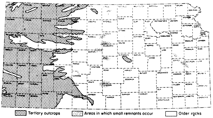
Character and surface distribution--Deposits of Tertiary age occur widely in central and western Kansas, and locally in eastern Kansas. The Tertiary rocks are all continental in origin and were deposited mostly by streams. The source area of most of the Kansas Tertiary was to the west, principally the area of igneous rocks in the Rocky Mountain region and the area of sedimentary rocks in eastern Colorado and western Kansas. The thickness of the Tertiary deposits ranges from a thin veneer to about 350 feet, but the maximum thickness has nowhere been observed at the surface. It is judged that the upper surface of Tertiary alluvium constituted a plain of low relief that merged westward with the erosion surface in the mountains and eastward with a subdued erosion surface in the Flint Hills area. The Flint Hills stood as a low but important drainage divide and were a minor source of sediments (mostly chert gravels) both to the west and east.
Figure 7--Distribution of Pliocene deposits.
Subsurface features--The Tertiary deposits in western Kansas mantle an erosional topography of subdued relief. The beds progressively overlap on gentle valley sides, the early Pliocene sediments being restricted to relatively narrow strips whereas the late Pliocene sediments, except where removed by erosion, are widespread. A nonconformity exists within the Tertiary strata of Meade and Seward Counties.
Figure 8--Pliocene rocks in Kansas.
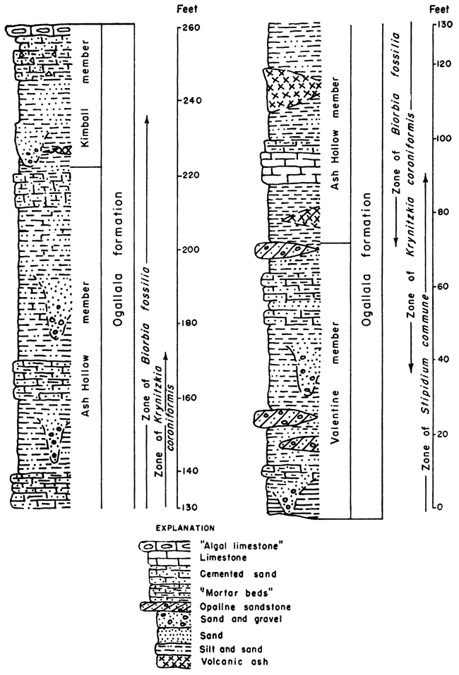
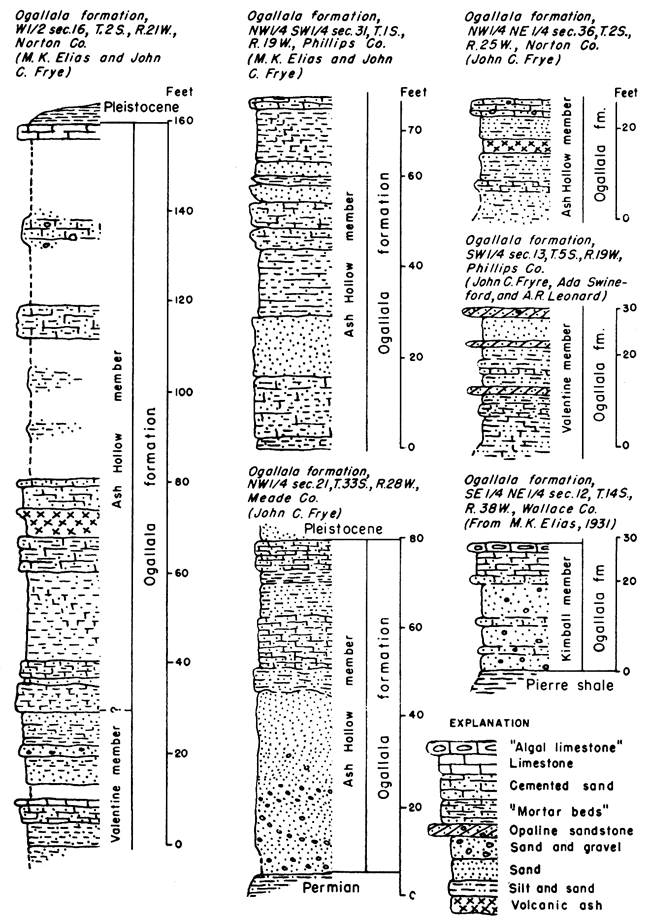
Figure 9--Selected stratigraphic sections of Pliocene deposits.
Pliocene Series
The Tertiary rocks of Kansas, so far as is known, are all included within the Pliocene Series.
Ogallala formation
Arkosic gravel, sand, and silt, locally cemented with calcium carbonate; massive to cross-bedded; limestone, volcanic ash, opaline sandstone, and bentonitic clay; greenish-gray, pink, red, tan, and ash-gray. Distributed widely over the western one-third of Kansas and at a few places in the central part of the State. East of the Flint Hills, chert gravels in upland situations are of comparable age. Maximum thickness, 350 feet.
Kimball member--Sand, gravel, silt, chert, and caliche; locally a hard limestone, called "Algal limestone," occurs at top, and coarse channel gravels, probably comparable to the Sidney gravels of Nebraska, at base. Exposed at scattered localities, principally in northwestern and north-central Kansas. Thickness commonly 35 feet.
Ash Hollow member--Sand, gravel, and silt, in many zones loosely cemented forming "mortar beds"; soft fresh-water limestone, and volcanic ash; predominantly pink and gray. This middle Pliocene member is the most widely occurring unit of the Ogallala in Kansas. Maximum thickness, 200 feet.
Valentine member--Gravel, sand, and silt, locally loosely cemented forming "mortar beds"; greenish-gray, pink, and gray; opaline sandstone, bentonitic clay, and soft fresh-water limestone. Early Pliocene and possibly late Miocene. Equivalent in age to Laverne formation in Meade and Seward Counties. Maximum thickness, 140 feet.
A major unconformity marks the base of the Tertiary rocks. They are known to rest on all subdivisions of the Comanchean Series (Cretaceous) and on Permian redbeds.
Prev Page--Introduction || Next Page--Mesozoic
Kansas Geological Survey, Geology
Placed on web Oct. 28, 2008; originally published Jan. 1951.
Comments to webadmin@kgs.ku.edu
The URL for this page is http://www.kgs.ku.edu/Publications/Bulletins/89/03_ceno.html