![]()
Prev Page--Quality of Water || Next Page--Regions
Geologic Formations and Their Water-Bearing Characteristics
Permian System
Permian rocks of Leonardian age are the oldest rocks exposed at the surface in Rice County. These rocks crop out along the lower Little Arkansas River Valley.
Ninnescah Shale
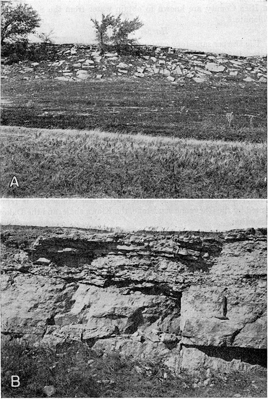
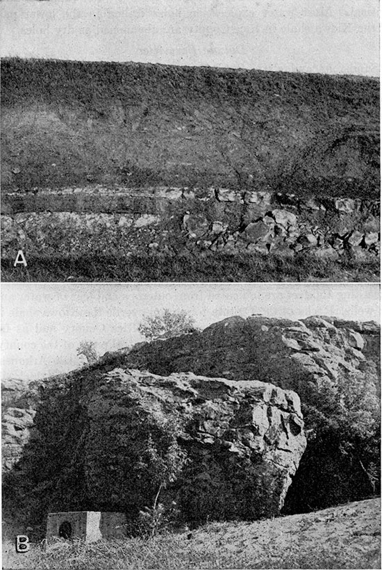
The Ninnescah shale, the oldest formation exposed at the surface in Rice County, is composed of shale, silty shale, and siltstone in beds of alternating red and light greenish gray. Thin beds of very fine, silty sandstone and minor amounts of gypsum are present in a few exposures. Slope detritus covers most of the steep bluffs in which the Ninnescah shale occurs (Pl. 5A), but a few clean exposures are to be found along the southwestern border of Little Arkansas River Valley (Pl. 1).
The Ninnescah shale yields small quantities of bard and generally highly mineralized water to a few domestic and stock wells in Rice County in the area of outcrop and beneath the dune sand in the southeastern part of the county.
Plate 5--A, Slump blocks of the Stone Corral dolomite covering slope on the Ninnescah shale in the SW NW sec. 11, T. 20 S., R. 6 W. B, Stone Corral dolomite in quarry in the SW NW sec. 11, T. 20 S., R. 6 W.
Stone Corral Dolomite
The type locality for the Stone Corral dolomite is in Rice County in sec. 11, T. 20 S., R. 6 W., where it conformably overlies the Ninnescah shale. The dolomite is massive at the base and slabby in the upper part. Numerous small clear calcite crystals in the matrix of light-gray dolomite give the rock a sandy appearance. The formation is about 6 feet thick at the outcrop (Pl. 5B), but increases in thickness westward in the subsurface to about 30 feet. Thicknesses of 30 feet of the Stone Corral, composed mostly of anhydrite, are indicated in logs and samples from oil wells drilled in western Rice County. Solution of the anhydrite by circulating ground water may have caused the thinning of the formation near the outcrop. No wells in Rice County are known to obtain water from the Stone Corral dolomite.
Harper Sandstone
The Harper sandstone conformably overlies the Stone Corral dolomite. It is composed mainly of red siltstone and very fine-grained, silty sandstone. Some light-gray to white shale and siltstone are present in most exposures. Test hole 18-6-16dd, near the eastern margin of this formation in Rice County, encountered 12 feet of siltstone, brick red with white mottling, below the Kiowa shale and above the Stone Corral. Exposures of the Harper sandstone are poor; they are found in a small gully in the SE sec. 25, T. 19 S., R. 6 W., and in gullies southwest of Little Arkansas River in T. 20 S., R. 6 W. A few wells in eastern Rice County obtain meager supplies of highly mineralized water from the Harper sandstone.
Cretaceous System
Cretaceous rocks underlie most of the northern half of Rice County and part of the southern half. The Cretaceous is represented by the Cheyenne sandstone, the Kiowa shale, and the Dakota formation.
Cheyenne Sandstone
The Cheyenne sandstone is present in the subsurface in northwestern Rice County, pinching out to the southeast against the Permian rocks. The Cheyenne sandstone unconformably overlies the Harper sandstone and Stone Corral dolomite and is unconformably overlain by the Kiowa shale. Test hole samples show the formation to be composed predominantly of siltstone, containing much very fine sand and ranging in color from white through light gray to greenish gray. Minor quantities of fine-grained white sandstone containing much charcoal occur in the Cheyenne. The basal part of the formation contains variegated silty sandstone with red-brown to purplish colors predominating.
Twenty-four feet of Cheyenne sandstone was encountered on the west county line in test hole 18-11-13dd. Four miles northwest of Lyons, samples from an oil-exploration well indicate approximately 19 feet of Cheyenne sandstone. Test hole 18-S-23aa in north-central Rice County encountered 42.5 feet of Cheyenne, the greatest thickness recorded in the county. Five and a half miles east of this location no Cheyenne was found; the Kiowa shale rests directly on Permian rocks (Pl. 3, cross section B-C).
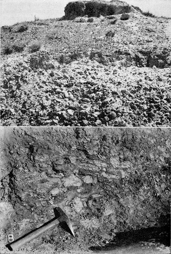
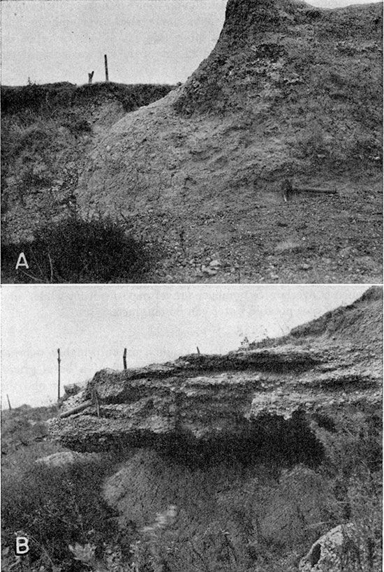
No surface exposures definitely identified as Cheyenne are known in Rice County. However, the purplish, red-brown, and greenish-gray sandstone and shale forming the matrix for a cobble zone at the base of the Cretaceous at a few localities in Rice County may be Cheyenne. An outcrop of these beds may be seen in a ravine in the SW SW sec. 32, T. 19 S., R. 6 W. (Pl. 6A). Cobbles from this zone are also numerous on weathered slopes in secs. 34 and 35, T. 20 S., R. 6 W. Test hole 18-8-23aa contained coarse gravel conglomerate at the base of the Cheyenne. Sandstone and shale containing fragments of plants are associated with the cobble zone in sections 27 and 28, T. 20 S., R. 6 W., and may be Cheyenne sandstone. These beds are a few feet above the near-by contacts of the Permian rocks and Kiowa shale and seem to represent inliers of the Cheyenne in the lower Kiowa shale, indicating a local unconformity between the two formations. Evidence of an unconformity, at least locally between the Cheyenne and Kiowa in southern Kansas, is mentioned by Moore and others (Twenhofel, 1924, p. 21).
Plate 6--A, Cobble zone at base of the Cretaceous in the SW SW sec. 32, T. 19 S., R. 6 W. B, Clay conglomerate in sandstone at base of the Dakota formation in the NW NW sec. 24, T. 18 S., R. 6 W.
A few wells in T. 20 S., R. 6 W., obtain quantities of water sufficient for domestic and stock use from sandstone which may be Cheyenne. Over most of the area of occurrence in Rice County the Cheyenne is deeply buried and consists of siltstone of low permeability, which yields no water to wells. It is generally covered by younger Cretaceous sandstones which yield adequate supplies of water.
Kiowa Shale
The Kiowa shale in Rice County is composed predominantly of dark-gray to black thin-laminated shales in the lower part and blue-gray to yellowish clay and shale in the upper part. Sandstones occur throughout, but are coarser-textured and more widespread in the upper part of the formation. Pyrite, glauconite, and marine shells are common in the sandstone beds. Marine shells are abundant also in two thin limestone beds in the lower part of the Kiowa. Along its outcrop in eastern Rice County the Kiowa shale is divisible into units which may be correlated with the members of Twenhofel's Belvidere formation in his Natural Corral section in northwestern McPherson County (Twenhofel, 1924, p. 31). Twenhofel proposed these members merely for convenience, to designate the occurrence of fossils and the stratigraphic position of exposures. The various units of the section at Natural Corral are similarly used here for local stratigraphic correlation. Regional significance to the local subdivisions is not implied.
This division of the Kiowa shale into members is applicable to the formation along the outcrop and in the subsurface in Rice County. The Kiowa-Dakota contact is arbitrarily drawn at the top of Twenhofel's Mentor member, because marine fossils are common in and below the Mentor and are not found in Rice County above this horizon. Fossil leaves of terrestrial plants occur below the Mentor of Twenhofel, but are more common in the overlying sandstone; thus the contact between the predominately marine beds of the Kiowa shale and the nonmarine beds of the Dakota formation is arbitrarily placed at the top of the uppermost zone known to contain abundant marine fossils. It is recognized that some marine beds placed in the Kiowa may be equivalent in age to, or younger than, nonmarine beds that have been correlated with the Dakota formation farther north. Intercalated near-shore marine and nonmarine deposits can be recognized in the area. The probable conditions of deposition of the Kiowa shale and Dakota formation in central Kansas have been discussed by Plummer and Romary (1942, pp. 340-347).
The horizon of the Kiowa-Dakota contact at many places in Rice County, where the fossiliferous Mentor of Twenhofel is absent, is marked by an abrupt irregular change from the fine- to medium-grained sandstone of Twenhofel's Marquette member of the Kiowa to the coarse sandstone in the lower part of the Dakota. In a few places, this basal zone of the Dakota contains cobbles and boulders of clay and shale in a matrix of soft sandstone (Pl. 6B). The underlying Marquette of Twenhofel is usually topped by a zone of highly concretionary concentrically banded, calcareous or ferruginous sandstone (Pls. 7 and 8A) . Very resistant concretionary calcareous sandstone, often called quartzite (Swineford, 1947), is found also at two other zones in the Kiowa (Pl. 8B) and in the Dakota formation in other areas (Plummer and Romary, 1942, pp. 329-333). The two lower zones are in Twenhofels Windom member of the Kiowa and occur in association with, or as replacements of, the coquinas or shell beds. Also associated with the three zones of calcareous sandstone concretions are beds of cone-in-cone limestone which may occur in place of either the shell beds or quartzites. A generalized section of the Kiowa in Rice County is given below.
Plate 7--A, Erosional remnant of resistant calcareous sandstone near the top of Twenhofel's Marquette member of the Kiowa shale in the NE NW sec. 28, T. 18 S., R. 7 W. B, Close up of weathered surface shown in A.
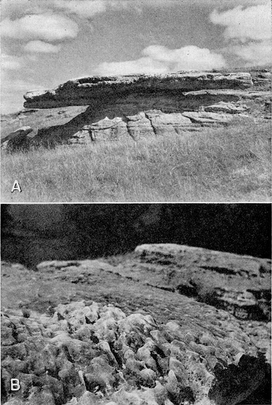
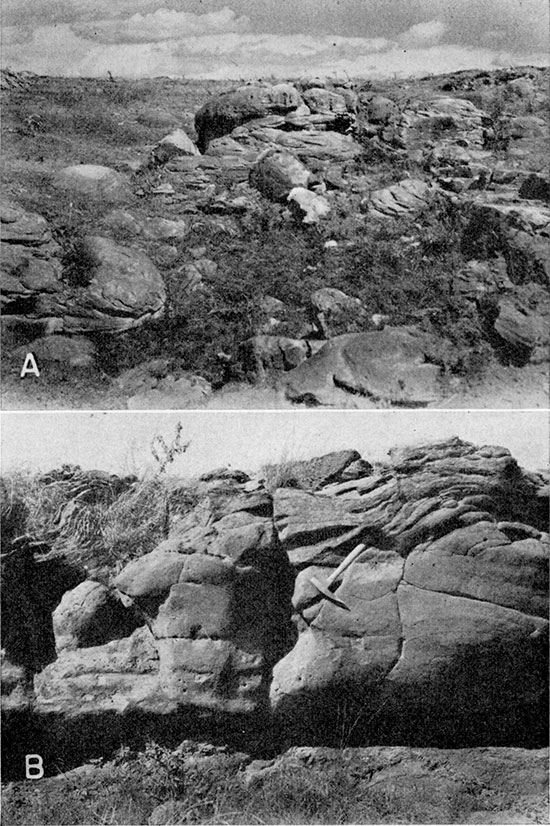
Plate 8--A, Calcareous sandstone concretions weathered from Twenhofel's Windom member of the Kiowa shale in the NW SE sec. 16, T. 20 S., R. 6 W. Springs issue from the base of the sandstone at this locality. B, Concretionary, iron-cemented zone near the top of Twenhofel's Marquette member of the Kiowa shale in the SE SW sec. 3, T. 18 S., R. 6 W. A zone of abundant fossils from Twenhofel's Mentor member is 5 feet. above the top of this sandstone on the same slope. Many springs in this area issue from this part of the sandstone.
| Generalized section of the Kiowa shale in Rice County | Thickness, feet |
|
|---|---|---|
| Dakota formation | ||
| Clay, blue gray, mottled red and white, or sandstone, brown, often coarse, containing boulders and cobbles of clay or shale | ||
| Kiowa shale | ||
| Sandstone, medium to fine. (Twenhofel's Marquette and Mentor members) Zone of calcareous quartzite concretions or concentrically banded, highly ferruginous zone often occurs near the top. Mentor fossils, where present, are in this upper strongly cemented zone. Thin cone-in-cone zone occurs sporadically above the quartzite nodules. The sandstone grades downward into yellow' to blue-gray clay or shale. Sandstone and shale are often interbedded near the base | 60 | |
| Shale, gray to dark gray. (Twenhofel's Windom member) A coquina limestone, and/or cone-in-cone and/or zone of calcareous sandstone concretions occur at the top and bottom of the member | 20 | |
| Shale, thin-bedded, gypsiferous, dark gray. (Twenhofel's Natural Corral member) Selenite crystals are common on the outcrop. The lower part of the shale may contain thin lenses of silty, pyritic, fine-grained sandstone (Pl. 9A) | 30 | |
| Permian System | ||
| Red, gray, and blue-gray shales | ||
The thickness of the Kiowa shale in Rice County, as shown by logs of test holes and by the measured section, ranges from about 95 to 130 feet. The Kiowa shale is exposed extensively along tributaries on both sides of Little Arkansas River Valley and sporadically along the northern bluff of Arkansas River Valley, east of Lyons and between Raymond and Silica.
The sandstone in the upper part of Twenhofel's Marquette member of the Kiowa is an important aquifer in Rice County. Many springs issue from this sandstone and most of the farm wells in the northeastern part of the county obtain abundant supplies of relatively soft water from it. Little River Lake, 2 miles west of the town of Little River, is fed by contact springs where Twenhofel's Marquette sandstone overlies shale. Large-diameter wells in the Marquette sandstone, 3 1/2 miles north of Little River, furnish the municipal water supply for that city (wells 18-6-29dda and 18-6-29ddd, Table 6, log 2, Table 7).
The lower shaly part of Twenhofel's Marquette member and his Windom and Natural Corral members furnish only meager supplies of highly mineralized water. The area designated S2b on the ground-water map (Pl. 2) is the outcrop area of the lower part of the Kiowa and is the area in which the ground-water supply is most critical. Most water exploration holes drilled in the lower part of the Kiowa shale in Rice County are abandoned as dry holes.
Plate 9--A, Contact between Permian rocks and overlying Kiowa shale in stream cut in the NE SE sec. 17, T. 20 S., R. 6 W. A sandstone lens pinching out to the left toward a local high in the Permian is 8 inches thick at the right of the picture. Sharp contact of the black fissile shale and the underlying light-gray siltstone of the Permian is seen at the left about 18 inches below the sandstone. B, Twenhofel's Marquette sandstone member of the Kiowa shale south of Little River Lake in the NW sec. 13, T. 19 S., R. 7 W. A spring is shown at the lower left.
Dakota Formation
Sandstone and clay of the Dakota formation are the youngest Cretaceous rocks in Rice County. The uppermost beds of the Dakota formation do not occur in the county. In Rice County the Dakota formation is composed of variegated clay, shale, siltstone, and irregularly distributed channel sandstones. "Ironstone," highly ferruginous, hard cemented nodules or beds, is common throughout the formation. For a generalized section of the Dakota in north-central Kansas the reader is referred to Plummer and Romary (1942, pp. 328-329).
In sec. 16, T. 18 S., R. 6 W., 75 feet of the Dakota formation, mostly channel sandstone, overlies the Kiowa shale. This is the maximum thickness of the Dakota formation in eastern Rice County. No test holes were drilled through the maximum section of Dakota in northwestern Rice County, but thicknesses of Dakota exceeding 150 feet are indicated from outcrops and logs of water and oil wells. Rocks of the Dakota formation overlie the Kiowa shale in most of the northern tier of townships in Rice County and as far south as Mitchell in the east-central and central parts of the county. Outcrops are not common, however, except in the Little Arkansas River basin, because most of the Dakota is overlain by the thick silt of the Sanborn formation.
Most of the wells in north-central and northwestern Rice County obtain water from sandstones in the Dakota formation. In general, water from these sandstones is softer than water from the deposits of gravel within the county, but in many places the water contains an objectionable amount of iron. The chloride content of Dakota waters is usually higher than that of water from the gravel, but it is low enough to be satisfactory for domestic use in most of the area. Many chemical analyses of water samples from the Dakota formation are given in Table 5 and additional chloride determinations are given in Table 3. The quantity of water available from the Dakota formation, where favorable thicknesses of channel sandstone are present, is second only to the late Pleistocene channel and terrace gravels. The Cities of Bushton and Geneseo obtain municipal water supplies from the Dakota, and several industrial wells obtain yields of 50 to 70 gallons a minute from wells in the Dakota formation in the northwestern part of the county (see records of wells, Table 6).
Tertiary System
Ogallala Formation
The Ogallala formation in Rice County consists of gravel, sand, silt, and limestone preserved as erosional remnants lying on resistant Cretaceous beds. "Algal limestone" rubble is found on the shoulders of hills in the NW SW sec. 19, T. 18 S., R. 8 W., and the SW SE sec. 10, T. 18 S., R. 10 W., and overlies Tertiary sand and silt capping the bluff half a mile north of Raymond. The best exposure of Ogallala north of Raymond is in a road cut at the cen. N2 sec. 27, T. 19 S., R. 10 W. Test hole 20-10-10dd passed through 19.5 feet of Ogallala resting on sandstone of the Kiowa shale. This Tertiary material is composed of fine sand and gray, yellow, and greenish-gray silt with a small amount of fine gravel (Log 60).
The three small areas mentioned above are the only known occurrences of Tertiary deposits in Rice County. These beds are assigned to the Ogallala formation primarily because of the "Algal limestone" cap rock and topographic position. The limestone shows concentric banding and oolitic structure which is typical of the "Algal limestone" at the top of the Ogallala in Kansas and adjoining states. The easternmost outcrop of "Algal limestone" in Rice County is in R. 8 W. The easternmost location noted by Frye (1945, p. 90) in Ellsworth County is also in R. 8 W. The three isolated outcrops in Rice County are at approximately the same altitude, 1,750 feet, as determined by topographic maps. This corresponds with the nearly level surface postulated for the Ogallala at the time of "Algal limestone" deposition.
No wells are known to obtain water from the Ogallala formation north of Raymond, which is the only area in Rice County where Ogallala rocks of permeable nature occur below the water table.
Quaternary System
Pleistocene Series
Unconsolidated sand, gravel, and silt deposits of Pleistocene age lie at the surface in most of Rice County. The lower part of the Pleistocene beds in the county consists of sand, gravel, and silt deposited in narrow valleys incised 150 to 200 feet below the present surface. The fillings of these deep valleys offer an unusually complete record of Pleistocene deposition.
Chase Channel Formation
The lowermost Pleistocene deposit is designated the Chase Channel formation because of its subsurface occurrence in a complete section in the Chase Channel. The type locality for the Chase Channel formation is the buried filled valley named Chase Channel from its development at the town of Chase in Rice County. The type section is well shown in test hole cuttings (no. 20-9-10dd) drilled through these deposits in the vicinity of Chase. The formation is shown in cross sections A-B, D-E, G-H, and I-J on Plate 3. Descriptions of the Chase Channel formation are given in logs 54, 55, 56, 73, and 78 at the end of this report.
The Chase Channel formation is considered to be of Nebraskan and Aftonian age and equivalent to the Holdrege and Fullerton formations of Nebraska classification for the following reasons:
- The depth of dissection below the top of the Ogallala (230 feet in the Chase Channel) indicates that it is post-Pliocene.
- Its position below the Meade formation of late Kansan and Yarmouthian age indicates early Pleistocene age.
- The widespread occurrence of silt containing nodular caliche below the basal gravels of the Meade formation suggests a time of soil development prior to deposition of the Meade.
- There is a recognizable difference between the lithology of the gravel of the Chase Channel and gravel of the Meade formation.
- The consistent lithology of the gravel of the Chase Channel formation beneath lateral lithologic variations in the Meade indicates a major change of drainage pattern between the time of deposition of the Chase Channel gravel and the time of Meade deposition.
Holdrege member--The basal material in these channels is medium to fine gravel and sand composed mostly of fragments of Cretaceous "ironstone, sandstone, and limestone." Many of the larger granules are fragments of Cretaceous shells. The small proportion of well-rounded granitic gravel in most of the samples was probably derived from the thin Tertiary deposits on the uplands surrounding the area and to the west. Fragments of red shale and siltstone are common in the gravel and sand where it rests on Permian rocks. The maximum thickness of this gravel and sand is 28 feet in the Chase Channel and 56 feet in the buried channel in the extreme southwest corner of the county.
Fullerton member--The coarse channel material grades upward into a gray silty clay containing much sand. Twenty to 30 feet of this material was encountered in test holes. Tan silt, containing large caliche nodules suggestive of an illuvial zone of a soil developed on fine-textured material, is present in many areas overlying the finer channel material. [Note: Illuvial soil contains constituents, such as colloids, added to the soil from outside sources. In contrast, eluvial soil comprises the residue of soil materials after removal of materials, such as colloids.] In a few localities this silt directly overlies the gravel. A maximum thickness of 22 feet of the silt was encountered in the Chase Channel.
Silt of an age comparable to part of the channel facies may be present in the terrace deposits of Little Arkansas River. Where exposed in a narrow strip in the SE SE sec. 27, T. 18 S., R. 7 W., it contains many fragments of vertebrate fossils (Pl. 10A). One tooth and several tooth fragments were identified by C. W. Hibbard (oral communication) as Plesippus simplicidens.
Plate 10--A, Silt of the Chase Channel formation in the SE, SE sec. 27, T. 18 S., R. 7 W., overlying the Kiowa shale. The hammer rests on the surface of the shale. Teeth of Plesippus simplicidens were taken from the basal part of the silt. B, Conglomerate of the Meade formation in the terrace east of Little Arkansas River in the NE SE sec. 27, T. 18 S., R. 7 W.
A few wells in Rice County in the Little Arkansas River terrace area obtain meager supplies of moderately hard water from basal rubble deposits which may be equivalent to part of the Chase Channel formation. No wells in Rice County obtain water from the thick buried channel gravels of this formation and water samples taken from two test holes show that the water is highly mineralized. The Chase Channel formation in most of its area of occurrence is overlain by younger gravel deposits from which adequate supplies of potable water can be obtained.
Meade Formation
The Meade formation in Rice County unconformably overlies the Chase Channel formation. It is composed of a basal gravel member and an upper silt member. The gravel member and the silt member are equivalent to the Grand Island formation and Sappa formation of late Kansan and Yarmouthian age (as classified by the Nebraska Geological Survey). The Grand Island and Sappa are assigned to member rank in this paper. The association of the Pearlette ash with the upper silt member of the Meade formation in Rice County indicates close correlation with material of late Kansan and Yarmouthian age in Kansas and adjacent states. The Pearlette ash with associated fossil zones has been traced from Texas to Iowa and established as a marker bed for correlation of this part of the Pleistocene deposits of the southern and central plains region with the northern glacial section (Frye, Swineford, and Leonard, 1948).
Grand Island member--Distinct lithologic differences within the Grand Island member are recognized. The more widespread gravel in the southern and southwestern parts of the county is fine to medium, composed mainly of granitic material of Rocky Mountain type. This gravel was deposited by a major stream that flowed east across the southern part of the county. The Grand Island member of the Meade formation in the northern part of the county is confined to narrow tributary channels which flowed southeastward into the trunk stream. The gravel in the tributary channels is composed of fragments of Cretaceous rocks, water-worn caliche nodules, and minor quantities of finer granitic gravel, probably representing reworked Tertiary material. This gravel resembles the gravel of the Holdrege member of the Chase Channel formation in Rice County, except for the common occurrence of water-worn caliche nodules in the Grand Island. The source of these caliche gravels is probably the nodular caliche in the Fullerton member of the Chase Channel formation. The abundance of caliche gravels in the Grand Island in most of the test-hole samples and the striking absence of this type of material in the Holdrege suggest that the Fullerton represents the earliest Pleistocene occurrence of the thick silt that was deposited under conditions favorable to the development of a widespread illuvial soil zone and the formation of abundant calcium carbonate nodules. This interpretation is consistent with the recognition of the Fullerton as the earliest interglacial deposit in the area.
The Grand Island member in the narrow Chase Channel attains a thickness of 25 feet. The thickness of the granitic facies of the Grand Island in the southwestern part of the county probably exceeds 25 feet, but accurate identification of the top of the Grand Island member in that part of the area is not possible from well samples because of its lithologic similarity to the gravel overlying, and deposited in channels cut into, the Meade. The granitic facies of the Grand Island member does not crop out in Rice County and is known only from drill cuttings from wells and test holes.
Sappa member--The basal gravel (Grand Island member) of the Meade grades upward into sand, sandy silt, and silt classed as the Sappa member of the Meade formation. [Note: The Nebraska Geological Survey is now using the name Sappa to designate deposits formerly called Upland (Reed, 1948); throughout this report the name Sappa will be applied to beds called Upland in earlier literature.] Volcanic ash lentils 2 to 5 feet thick were encountered a few feet above the top of the Grand Island member of the Meade in 6 test holes in the county. This ash is identified as Pearlette ash, which occurs in the Meade formation of Kansas and from Iowa to Texas. The silt is gray to tan and buff and large nodules of caliche are abundant in the upper part. It overlies the Grand Island gravel and is seemingly continuous over much of the upland area of the county. The exact thickness of the Sappa member in Rice County is not known as it is overlain by the thick tan Loveland silt member of the Sanborn formation, from which it is not distinguishable in test holes. Drill cuttings and outcrops indicate a greater concentration of calcium carbonate and development of larger nodules of caliche in the Sappa as compared to overlying silts. Positive identification of the Sappa member in Rice County, however, except in close association with the Pearlette ash, is not considered feasible from available data. Volcanic ash was encountered in test hole 20-5-18bb in the terrace area of Little Arkansas River. Lenses of conglomerate of the Meade formation are found in the terrace northwest of Little River (Pl. 10B).
Many wells in the loess-covered upland area of northern Rice County and along the Little Arkansas River terrace obtain small supplies of hard water from a zone of lag gravels of the Meade resting on the eroded surface of Cretaceous and Permian rocks. Most of the wells drilled in recent years in the central and northern parts of the upland area, however, have been drilled into the underlying Cretaceous sandstone to obtain a larger supply of water. The thicker gravel and sand of the Meade formation in the Chase Channel and Arkansas River Valley areas are overlain by later gravel and sand zones, from which adequate water supplies can be obtained. Consequently, most wells in these areas do not extend into the Meade formation. A few wells in southwestern Rice County in the uplands south of Arkansas River probably penetrate gravel of the Meade formation.
Sanborn Formation
The Sanborn formation (Frye and Fent, 1947) in Rice County is represented by three widespread silt members separated in the uplands by buried soil zones and in the major drainage ways by gravel deposits. The upland silt facies of the silt members of the Sanborn formation are considered to be largely loess of eolian and fluvio-eolian deposition. The physiographic relationships of the upland facies of this material to the valley facies indicate that wind played a major part in the transportation of this material to its point of deposition. The three silt members and associated gravel members are discussed below in' ascending order.
Loveland silt member--The Loveland silt is composed of tan to buff silt and sandy silt and is identifiable over most of northern Rice County, where a thickness of 40 to 60 feet is common on the uplands and as much as 90 feet is known to exist in the filling of the buried channel southwest of Bushton (cross section on B-C, Pl. 3). As much as 25 feet of Loveland was encountered in test holes in the Chase Channel where the Todd Valley gravel and sand member is channeled into the upper part of the Loveland member.
The well-developed Loveland soil is developed in the upper part of the Loveland silt on the uplands. This soil is easily recognized in test holes and road cuts immediately below the Loveland-Peoria contact. The best exposure in Rice County of this buried soil zone and the associated silt members of the Sanborn formation is seen in a road cut in the NW cor. SW sec. 7, T. 18 S., R. 7 W., 1 mile southeast of Geneseo. A measured section of this cut is given below.
| Measured section in a road cut in the NW cor. SW sec. 7, T. 18 S., R. 7 W. | Thickness, feet |
||
|---|---|---|---|
| Sanborn formation | |||
| Bignell silt member | |||
| 4. Silt, light tan to yellow gray; thin soil developed at top | 1.5 | ||
| Peoria silt member | |||
| 3. Silt, light tan, shows faint columnar cleavage; contains some very fine to fine sand and irregular nodules and tubules of calcium carbonate. Prominent Brady soil at top | 6.4 | ||
| Loveland silt member | |||
| 2. Silt, dark brown to gray, blocky; contains fine sand and tubules and root casts of calcium carbonate. A and upper B horizons of Loveland soil | 2.0 | ||
| 1. Silt, tan; contains very fine sand and calcium carbonate nodules and a few snails | 4.5 | ||
| Dakota formation | |||
| Clay and shale | |||
The Loveland silt is the most widespread member of the Sanborn formation in Rice County. It covers most of the northern half of the county and is probably present in the subsurface south of Arkansas River. The thick tan silt encountered in test holes and observed at a few exposures south of Sterling is tentatively assigned to the Loveland. In Rice County the Loveland is correlated with the Loveland silt member of northern Kansas and the Loveland formation of Nebraska.
There is little evidence of extensive channel deposition at the base of the Loveland. The channel facies, which would be equivalent to the Crete formation of Nebraska, is not identifiable in the northern part of the county. Some of the sand bodies encountered in the Chase Channel near the Loveland-Sappa contact may represent minor Crete channeling and deposition. It is also possible that granitic gravel deposits above the Meade formation in the southern and southwestern parts of the county may be equivalent to the Crete (cross section I-J, Pl. 3). There gravel channeled into the zone of volcanic ash and probably extending beneath the Todd Valley sand gravels member (by projection) may be equivalent to Crete.
The Loveland silt is made up almost entirely of silt of very low permeability, which yields little or no water to wells. A few wells in northwestern Rice County, however, obtain water from zones of calcium carbonate accumulation in the silt of the Loveland member. Wells obtaining water supplies from the silt were found in the buried valley southwest of Bushton. This unusual water-bearing capacity of a silt is ascribed to secondary openings in a partly indurated section rather than to original permeability of the silt.
Todd Valley sand member--The Todd Valley sand member of the Sanborn formation in Rice County is represented by coarse to fine gravel and sand channeled into the Loveland silt. The gravel is derived from granites of the Rocky Mountains. In the Chase Channel, 15 to 80 feet of sand and gravel identified as the Todd Valley sand member was encountered in test holes. The greatest thickness was found near the west county line (section A-B, Pl. 3). The sand deposit occurs over most of the Chase Channel and is preserved in the broad area of alluvial deposits between Arkansas River and the City of Lyons. Three miles south of Lyons, the north border of a terrace remnant 3 miles wide and 7 miles long is the fourth terrace above the alluvium of Arkansas River. This terrace has been dissected on the north and northwest by Cow Creek and its tributaries and on the south by the ancestral Arkansas River. The present surface of the terrace is clearly deflationary. Small low dunes are present on the terrace, but most of the surface is composed of hummocky areas of coarse sand to fine gravel lag beneath a thin soil.
Sand and gravel of the Todd Valley member yields large supplies of water of good quality to wells in the Chase Channel and in the terrace remnant 3 miles south of Lyons. The City of Chase obtains its water from a well penetrating the Todd Valley gravel and sand member (well 19-9-31, Table 6).
Peoria silt member--The Peoria silt overlies the Todd Valley member in the Chase Channel and overlies the Loveland member over most of the uplands in the northern part of the county. This silt occurs typically as loess on the uplands where it is light gray to greenish gray in color and contains some very fine to fine sand and small nodules and tubules of caliche. The thickness in the uplands is 4 to 7 feet. The Brady soil occurs at the top of the silt. In the Chase Channel the Peoria is red-tan silt, 10 to 40 feet in thickness, and contains much sand and nodular caliche. A good exposure of valley facies of Peoria silt is seen in a cut a quarter of a mile south of Chase beneath a thin dune-sand deposit.
The Peoria silt yields no water to wells in Rice County. Over most of the county it is above the water table and in the Chase Channel it is relatively impermeable, acting as a barrier to downward percolation of water from the overlying dune sand.
Bignell silt member--The Bignell silt is identifiable in only a few scattered localities in Rice County. About 1.5 feet of light-tan to yellow-gray silt identified as Bignell occurs in a road cut in the NW cor. SW sec. 7, T. 18 S., R. 7 W. At that locality the Bignell silt has a thin soil at the top and overlies the Brady soil developed on the Peoria silt. A light-gray silt 2 to 3 feet thick overlying the soil developed on the Peoria in the Chase Channel is considered to be equivalent to the Bignell of the uplands. The Bignell in the Chase Channel area occurs north and east of the sand dunes which are west and south of the city of Chase. The Bignell silt is considered to be of late Wisconsinan age. This silt is everywhere above the water table in Rice County and yields no water to wells.
Late Wisconsinan terraces
The alluvial deposits younger than the Todd Valley member of the Sanborn formation and older than Recent alluvium are grouped together in this report as the late Wisconsinan terraces. Three terraces are identifiable between Sterling and Raymond in the broad alluvial plain north of Arkansas River. The second and third terrace borders are marked by rounded scarps 5 to 10 feet high. The first terrace is a small incipient terrace that begins in an abrupt scarp that rises 2 to 5 feet above the present alluvial plain. Over most of the valley these terrace scarps are masked by dune sand or obscured by erosion. Near Raymond, where Arkansas River is still near the northern bluff of the valley, only one terrace level is found above the flood plain north of the river. This may be equivalent to all or one of the three terraces found between Raymond and Sterling. The material in these terraces is mostly coarse to fine gravel and sand.
Pebble concentration resembling lag gravels, especially in the area northeast of Sterling, probably indicates extensive lowering of the terrace surface by wind deflation or action of streams incompetent to move the larger material (logs 70 and 73).
The broad alluvial terraces mapped along Cow, Calf, Plum, Lost, and Little Cow Creeks and Little Arkansas River are considered to be late Wisconsinan in age. The present streams in these valleys are small incompetent streams that are incised in the deep silt filling of the broad alluvial deposits (Pl. 4A). The channel fill beneath the broad terrace surfaces is much deeper than the present depth of stream scour. The late Wisconsinan alluvial plain is much wider than the present meander belt. The late Wisconsinan alluvium of Cow Creek is cut through the Todd Valley sand member of the Sanborn and into the underlying loess of the Loveland member (cross sections D-E and G-H, Pl. 3). This Pleistocene alluvium joins t.he third terrace in Arkansas River Valley, seemingly without a topographic break. The material that fills these deep tributary valleys is mostly sandy silt with lenses of fine to medium sand. Some coarser material is present locally.
The sand and gravel deposits underlying the Wisconsinan terraces in Arkansas River Valley yield large supplies of water of variable quality to wells in Rice County. All the larger irrigation wells obtain water from gravel of this age. The municipal wells of Sterling are located on the second terrace surface, although part of the water supply may come from pre-Wisconsinan sand and gravel. The municipal wells at Lyons are located in the late Wisconsinan terrace of Cow Creek where most of the terrace material is derived from Todd Valley and older granitic gravel. These wells probably also penetrate undisturbed Todd Valley material in their lower part.
The quality of water is determined by several factors. In the first 2 or 3 miles north of Arkansas River, the water generally has a high chloride and sulfate content. As the distance from the river increases, the chloride and sulfate content gradually diminishes. Local recharge facilities and the amount of local precipitation modify these conditions.
The effect of precipitation variations on the chloride content of the ground water under different conditions of recharge is strikingly demonstrated by a comparison of the variations in the chloride content of the municipal water of Sterling and Lyons. The source of chloride in the Sterling area is probably recharge from Arkansas River at high-water stages and the chloride in water from the Lyons municipal wells is probably from the thin zone of high-chloride water at the base of the alluvium. The original source of the chloride is the Cretaceous or Permian rocks at the sides or base of the channel.
The record of annual chemical analyses of the two municipal wells shows that the chloride content of the water from the Sterling wells tends to vary directly with annual precipitation, while the chloride content of the water from the Lyons wells tends to vary inversely (Fig. 11). These variations do not completely correspond with the precipitation variations, because the total annual precipitation figures do not always indicate either high-river stage, which raises the chloride content in the river alluvium, or the amount of ground-water recharge, which lowers, by dilution, the proportion of chloride in alluvial material farther from the river at Lyons.
Figure 11--Graphs showing variations of the chloride content of water from the municipal wells at Lyons and Sterling and the annual precipitation at Alden.
.jpg)
The Wisconsinan terraces, mostly dune covered and with gravel near the surface in many places, offer excellent conditions for recharge from precipitation. Wells of 500 to more than 1,000 gallons a minute could be developed at many points in this broad area where adequate thicknesses of gravel are present.
Pleistocene and Recent Series
Dune Sand
Some of the sand-dune deposits in Rice County are considered to be of Wisconsinan age. The dune deposits consist mostly of medium to fine sand with local deposits of gray to greenish-gray silt that probably represent areas of interdune pond sedimentation. Most of the southwestern part of the county south of Arkansas River is covered by a thin veneer of dune sand (Pl. 11). Low dunes occupy large areas on the terraces north of the river. Thicker deposits of dune sand exist in the southeastern part of the county. This area is covered by a northwestward extension of the Hutchinson dune tract. Logs 61 and 62 show thicknesses of 19 and 43 feet respectively for dunes in this area.
Three or possibly four stages of dune building, ranging in age from Peorian to Recent, are indicated in Rice County by superposition and areal distribution relative to the silt members of the Sanborn formation.
High-level dune sand exceeding 30 feet in thickness occurs on the upland area north of Raymond between Chase Channel and Arkansas River Valley. This area is underlain by resistant Cretaceous rocks which crop out on the southern bluff of the divide. Beneath the dunes and overlying the Cretaceous rocks are. deposits of Pleistocene and Tertiary age, shown by test drilling to reach a combined thickness of 44 feet. A test hole in the SE cor. sec. 10, T. 20 S., R. 10 W. passed through 20 feet of dune sand and interbedded silt, 25 feet of Pleistocene silt and sand, and 19 feet of Tertiary sand and silt capped by "Algal limestone."
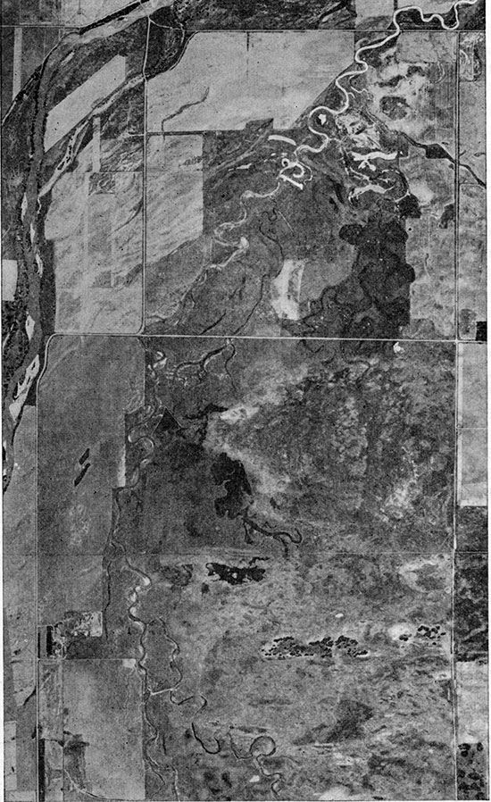
Plate 11--Aerial photograph of Rattlesnake Creek Valley southwest of Alden. Stream ponding by northward drifting dune sand in sec. 14, T. 21 S., R. 10 W. is seen in the center of the photograph.
Outcrops along the dissected south border of the dune area show dunes resting on Cretaceous sandstones, Tertiary material, and loess of the Loveland unit with a well-developed Loveland soil. None of the large stabilized dunes in this divide area was found to overlie deposits younger than the Loveland soil, although the younger loess deposits of the Peoria unit are extensive over similar upland areas in other parts of the county and occur around the margins of the dune tract. The dunes, at least in the basal part, are therefore considered to be equivalent to the Peoria silt member of the Sanborn formation.
A thin hummocky dune area, in places a sheetlike deposit, extends northward from the high-level dunes over the Chase Channel proper. This sand overlies an eroded or deflationary surface on the Peoria silt and Todd Valley sand members, and seems to grade laterally to the northeast into the typical Bignell silt member of the Sanborn. These thinner dunes and sheet-sand deposits are considered to be the coarser-textured equivalent to part of the Bignell silt and to be reworked in part from the dune sand of the Peoria to the south.
Small tongues of dune sand extending northward from the main body of the dunes of the Bignell member overlie the late Wisconsinan terrace of Cow Creek. In sees. 32 and 33, T. 18 S., R. 10 W., a northward extension of the sand is cut by the present channel of Cow Creek.
The source of the sand forming the thick high-level dune sand of the Peoria north of Raymond may have been the Todd Valley sand unit northwest of the dunes. Sand and gravel deposits of the Todd Valley are near the surface over much of the area north and northwest of Silica and deposits of the Peoria do not overlie the sand in this area. As the nearest obvious source for this dune sand, its position relative to the place of sand accumulation indicates a prevailing northwesterly direction for the dune-building winds. The post-Peoria dunes in the Chase area seem to have been derived principally from the larger sand dunes of the Peoria, extending northward from these dunes and indicating prevailing southerly wind directions. Sharp dunes, clearly of Recent age, and some actively moving areas are evident on most of the older dune deposits and obviously are derived from blow-outs in the once stabilized dunes. Sharp coarse-textured dunes occur just south of Cow Creek, 2 1/2 miles south of Lyons. The source of these dunes is probably the deflationary area of terrace deposits (Todd Valley) immediately south of the dunes.
A few wells in Rice County obtain water from dune sand. In the large dune tract in the southeastern part of the county, where dune sand overlies beds of Permian siltstone and shale of low permeability, wells ending in the sand are common. Even in this area, however, it is common practice to obtain water from a thin zone of rubble on top of the Permian where this is present, or to drill into the Permian shale and siltstone to avoid the mechanical difficulties attending development of wells ending in unconsolidated, medium- to fine-grained sand.
The water in the dune sand is of good quality except for excessive quantities of iron in much of the dune area near Hutchinson. The excessive iron content of water in the dune sand in the southeastern part of Rice County is indicated by the accumulation of iron around small seeps and springs near the margins of the area. The iron is precipitated by oxidation and forms a coating of iron oxide on the surface. At several localities the dune sand has become tightly cemented to form a resistant sandstone, which is often mistaken for sandstone of the Dakota formation. Sandstone of this type may be seen capping hills of dune sand in the SW SW sec. 18 and the SW SW sec. 3, T. 21 S., R. 6 W. Other less accessible exposures are found in sees, 9 and 10 of the same township. Some of these deposits are roughly oval in outline and are assumed to have been formed in the bottoms of the interdune water-table ponds which are common in the area (Pl. 48). Mud samples taken from the bottom of three water-table ponds in sec. 15, T. 21 S., R. 6 W. contained 0.74, 0.32, and 0.83 percent iron. A sample of the sandstone capping on erosional remnant of dune sand in the SW SW sec. 18, T. 21 S., R. 6 W. contained 15.9 percent iron.
Recent Series
Alluvium
Deposits of Recent age in Rice County are confined to parts of the dune sand discussed above and to the narrow strip of alluvium along Arkansas River. These deposits are outlined by the first terrace scarp on the north and a cut terrace in the dune sand and older alluvial material on the south. Recent alluvial materials along most of the tributary streams are thin transient deposits confined to the stream channels.
Very few wells in the county obtain water from Recent alluvium. Wells in Arkansas River alluvium yield water that is objectionably high in chloride and sulfate.
Prev Page--Quality of Water || Next Page--Regions
Kansas Geological Survey, Geohydrology
Placed on web June 16, 2015; originally published July 1950.
Comments to webadmin@kgs.ku.edu
The URL for this page is http://www.kgs.ku.edu/Publications/Bulletins/85/07_form.html