![]()
Prev Page--Chelsea Dome || Next Page--Character of oil and gas
Origin of the Eldorado Anticline And of Other Types of Structure Found in the Northern Part of the Midcontinent Oil and Gas Fields
Introductory Statement
Anticlinal folding is usually attributed to a buckling of strata under horizontal or tangential compressive forces which operate at right angles to the axes of the folds. This explanation is based principally on observations made in regions adjacent to mountain ranges which were caused by great orogenic movements. That similar forces have operated in the northern part of the Midcontinent region to produce anticlines and domes, such as those in the Eldorado and other fields, seems to the writer very difficult to conceive, for the source of such forces in the near-by regions is not apparent, and, besides, the strata of this region, consisting predominantly of shale, are comparatively weak and could not transmit horizontal forces through any considerable distance, because the weak strata would yield by crumpling and thus relieve the stresses. This was impressed on the writer during his investigation of the Bristow quadrangle, Creek County, Oklahoma (Fath, 1917, pp. 69-99), which led to the publication of a tentative solution of the problem in a paper entitled "The origin of the faults, anticlines and buried 'granite ridge' of the northern part of the Midcontinent oil and gas field." (Fath, 1920) The theory there advanced explains the folding as not caused by lateral thrust transmitted through the sediments of this region, but as in large part the surface expression of deep-seated readjustments along ancient faults or lines of weakness present in the pre-Cambrian basement rocks of the region.
The probable presence of such faults or lines of weakness in the basement rocks is suggested by (1) parallel belts of en echelon faults in the rocks exposed at the surface in northeastern Oklahoma, and (2) by the parallelism of these fault belts to many of the lines of anticlinal folding present throughout the oil-and gas-producing region of the northern part of Midcontinent field. The Eldorado field supplies additional evidence in support of this theory, and in order to show the relation which this field bears to the hypothesis, it seems essential to present in this place most of the original argument.
Origin of the En Echelon Faults
En echelon faults in the rocks at the surface in northeastern Oklahoma furnish the most direct evidence for the contention that ancient faults or lines of weakness exist in the basement rocks. The en echelon faults lie in a broad, northward-trending zone known to extend from Okfuskee county to Osage county, and probably continuing into Hughes and Seminole counties on the south and into the state of Kansas on the north. (See plate XVIII.) These faults, which locally modify the general westward dip of the strata, are normal faults—i. e., the hade lies in the direction of the downthrow—and are noteworthy not only because of the approximate parallelism of the individual faults, but also because of their grouping into belts or series which are parallel to one another but trend in a different direction from the individual faults. Most of the individual faults trend about No. 20° to 45° W., and lie en echelon to one another in such a manner that they form linear belts or series which trend from north to N. 25° E., or roughly at an angle of 45° with the trend of the faults. Some of these belts are 50 miles or more long. The faults are of minor magnitude both in vertical displacement and areal extent. One of the largest that the writer found has a stratigraphic throw of about 130 feet and a length of about 3 1/4 miles. Where they cut sandstone beds slickensided surfaces are developed, and these indicate that some of the fault planes dip southwest and some northeast, at angles which range between 50° and 65° from the horizontal.
[Note: Somewhat similar faults in southern Montana have been mapped and described by E. T. Hancock in "Geology and oil and gas prospects of the Lake Basin field, Montana"; U. S. Geol. Survey Bull. 691-D, pp. 101-147; 1918. Dr. Rollin T. Chamberlin has recently advanced a well-founded explanation for them in a paper entitled "A peculiar belt of oblique faulting"; Jour. Geol. XXVII, pp. 602-613; 1919. Chamberlin's discussion on pages 610-613 of his paper is quite analogous to the arguments presented here and deserves more consideration in this report than it is possible to give to it, for want of time.]
As mentioned above, the faults are normal—i. e., the downthrow is in the direction of the hade—and hence the immediate forces that caused the individual fractures were probably tensional in nature and operated horizontally in a direction normal to their trend, or N. 45° to 70° E. On the other hand, the linear grouping of these fractures into belts and their general uniform development throughout each belt suggest, as the most simple explanation, that the faults of any one series were caused by horizontal forces which operated in a direction parallel to the trend of the series—i. e., N. 0° to 25° E. The question at once arises, How can horizontal forces operate to produce belts 50 miles or more long of diagonal tensional faults in weak strata like the Pennsylvanian rocks of this region? The writer believes that the controlling forces were not transmitted by the weak Pennsylvanian strata, for the stresses would have been relieved by adjustment within the soft strata.
As the upper few thousand feet of strata in this region are too weak and incompetent to transmit such horizontal forces, some other agent must be sought. Lying at some unknown depth beneath the surface of this region there exist massive granites, quartzites and associated rocks which constitute the basement rocks, and above them there may be some massive limestones and sandstones such as are known in the St. Francis, Arbuckle, Wichita and other mountain ranges surrounding this region. A submerged "granitic ridge," which has previously been discussed under the head of stratigraphy, is known to underlie the Permian and Pennsylvanian strata in a part of eastern Kansas. These crystalline rocks are fully competent to transmit earth forces, and furthermore are more closely related to the deep-seated deformational movements of the earth than the higher beds. These competent crystalline rocks could transmit horizontal forces caused by movements along fault planes or shear zones in these older rocks through considerable distances in the overlying beds, especially if overlain by a heavy load of sediments. It is postulated, therefore, that the controlling or master forces that produced the long belts of faults at the surface operated in a direction parallel to those belts and were transmitted in a horizontal direction by the strong, massive, competent rocks which lie at considerable depth beneath the surface, and that the belts of parallel diagonal faults of the Midcontinent region are the natural surface expression in overlying weak rocks of such deep-seated horizontal movements.
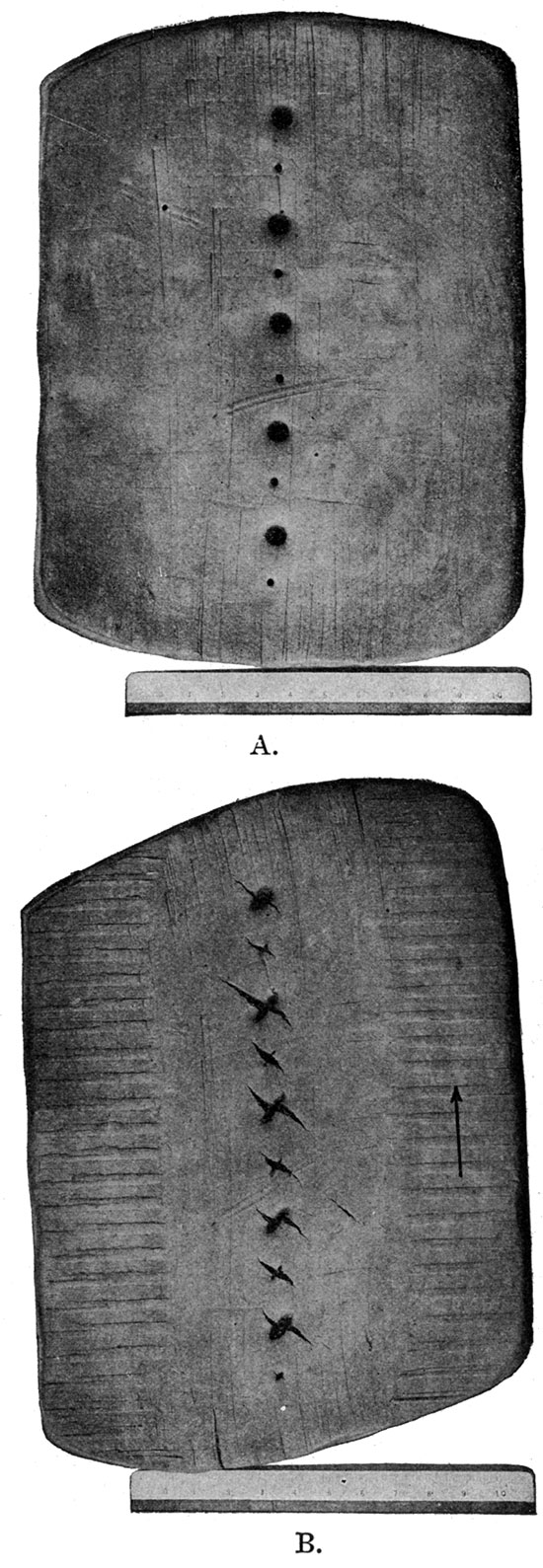
Since the strata overlying the deep-seated beds are relatively weak and yielding, their deformation will differ from that of the hard beds. Instead of breaking or shearing sharply along a nearly vertical plane or zone parallel to the fracture or shear zone in the underlying granites along which a horizontal displacement has taken place, they will be bent and the parts will tend to be dragged apart, so that tension will be produced diagonal to the direction of movement. This action may be demonstrated by drawing a circle on the side of a rubber eraser or other flexible substance and distorting the eraser by a shearing force acting in the direction shown in figure 8, the ends of the eraser being held firmly. The circle on the eraser will be distorted by being elongated in a diagonal direction. Contraction in a direction at right angles to the elongation may also be observed. The same effect accompanied by the production of fractures normal to the tension is pictured in plate XIX. In this illustration A is an undeformed flat piece of modeling clay partly pierced by several conical holes along a medial belt. B is the same piece of clay after being deformed by a force operating in the direction indicated by the arrow. The rounded holes have been elongated in the direction of tension, and fractures, which have been centralized by the weakening of the mass at the holes, have been produced at right angles to the direction of elongation, and the adjacent walls pulled apart. Minor compression perpendicular to the direction of elongation is indicated by the contraction of the holes in that direction.
Figure 8—A circle on a rubber eraser, elongated by distorting the eraser.
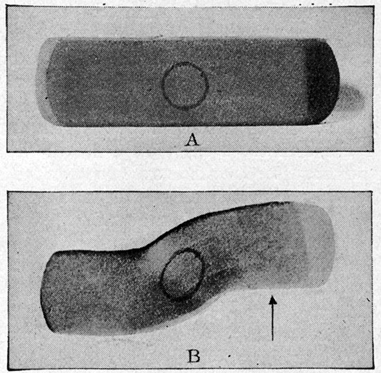
Plate XIX—Clay model showing en echelon fractures. A flat mass of modeling clay pierced by several conical holes, before and after being deformed.
Under this explanation, the fractures produced in the rocks immediately overlying the harder rocks in which the horizontal displacement occurred would be open tears which would remain open fissures if it were not for adjustment which would immediately take place in the thick series of overlying soft formations. In this adjustment the fractures would be closed up by the slumping or giving way of the soft, yielding rocks on one side or the other, which would result in a small vertical displacement of the beds on opposite sides of the fissures—i. e., there would be a normal fault. The fissuring itself would cause no displacement of the strata at the surf ace, but the after-adjustment does. While the deep-lying fractures may have been irregular tears, their upward extensions into the overlying, less-loaded material caused by the slumping would be straighter, and at the surface they would be represented by regular normal faults.
In applying this explanation to the faults in the Midcontinent field, the direction of the shearing movement in the hard, deep-lying, competent rocks must have been along the belts of faults, the territory on the east side of each fault belt having moved northward relative to the west side. Considering the faulted region as a whole, each unbroken strip on the east of a fault belt having moved northward relative to its respective strip on the west, the movement may be likened to a regional shearing, the belts of faults in the weak and yielding surface beds marking the location of the fault planes in the granite basement.
If the soft and yielding beds were sufficiently thick it is clear that faulting of this type would be gradually dissipated upwards and would not reach the surface. It is therefore probable that other such fault zones exist in the Pennsylvanian rocks beneath the surface which failed to reach the surface, because the movements which initiated them were not as great as those which produced the faults which now show at the surface, or which, as will be shown later, may have been formed previous to the deposition of the surface rocks. The possibility of such belts of deep-lying, diagonal faults which do not reach the surface is suggested in the Eldorado field by the supposed faulting of the Stapleton oil zone in sec. 27, T. 25 S., R. 5 E., as discussed on page 117. It is also slightly suggested by the anomalous production from the Stapleton zone in the central part of section 15 of the same township, and by the transverse-lying Bancroft and Dunkle synclines which, although but slightly developed in the surface rocks, are much more strongly developed in the Stapleton zone, and may with still greater depth be fractured and displaced.
Origin of the Anticlinal and Synclinal Folds
An extensive series of faults or shear zones in the pre-Cambrian basement rocks along which there was horizontal movement has been postulated to explain the belts of faults, but the movement along these ancient lines of weakness probably was not everywhere horizontal. Vertical movement would probably be even more common, and the effect in the overlying weak beds would be quite different from the belts of faults described above. It is a commonly recognized ~fact that faulting passes in distance into folding, and although the lowermost beds of overlying weak rocks would be faulted similarly to the hard rocks, this faulting would diminish in intensity away from the competent rocks, and at a sufficient distance would resolve itself into folding. It is the writer's opinion that many of the Midcontinent anticlines represent such folds, which are the effects in the soft formations outcropping at the surface of faults in the hard rocks of the pre-Cambrian basement. [Note: Since this report was written, "The origin of the central Kansas domes," by Dr. Eliot Blackwelder, has appeared in Bull. Amer. Assoc. Petr. Geologists, pp. 89-94, vol. 4, No. 1; 1920. In this article mention is made of another paper on the same subject by Dr. M. G. Mehl, which was read at the St. Louis meeting of the American Association for the Advancement of Science, in December, 1919. The opinions of these able geologists are worthy of careful consideration; but for want of time, no discussion of their papers can be undertaken for inclusion in this report. It is to be noted, however, that the main endeavor of both these writers, like that of the author of this report, is to find some explanation other than horizontal compressive forces to account for the Midcontinent type of anticlinal folds.] It is also the writer's opinion that some of the anticlines of this region can be only partly explained in this manner, and that others were probably formed by entirely different causes.
In all the folds in the area that have come to the writer's attention, and which probably formed in this manner, the causal movement consisted of a relative lowering of the area to the east, which, however, may actually have been a rise of the area to the west.
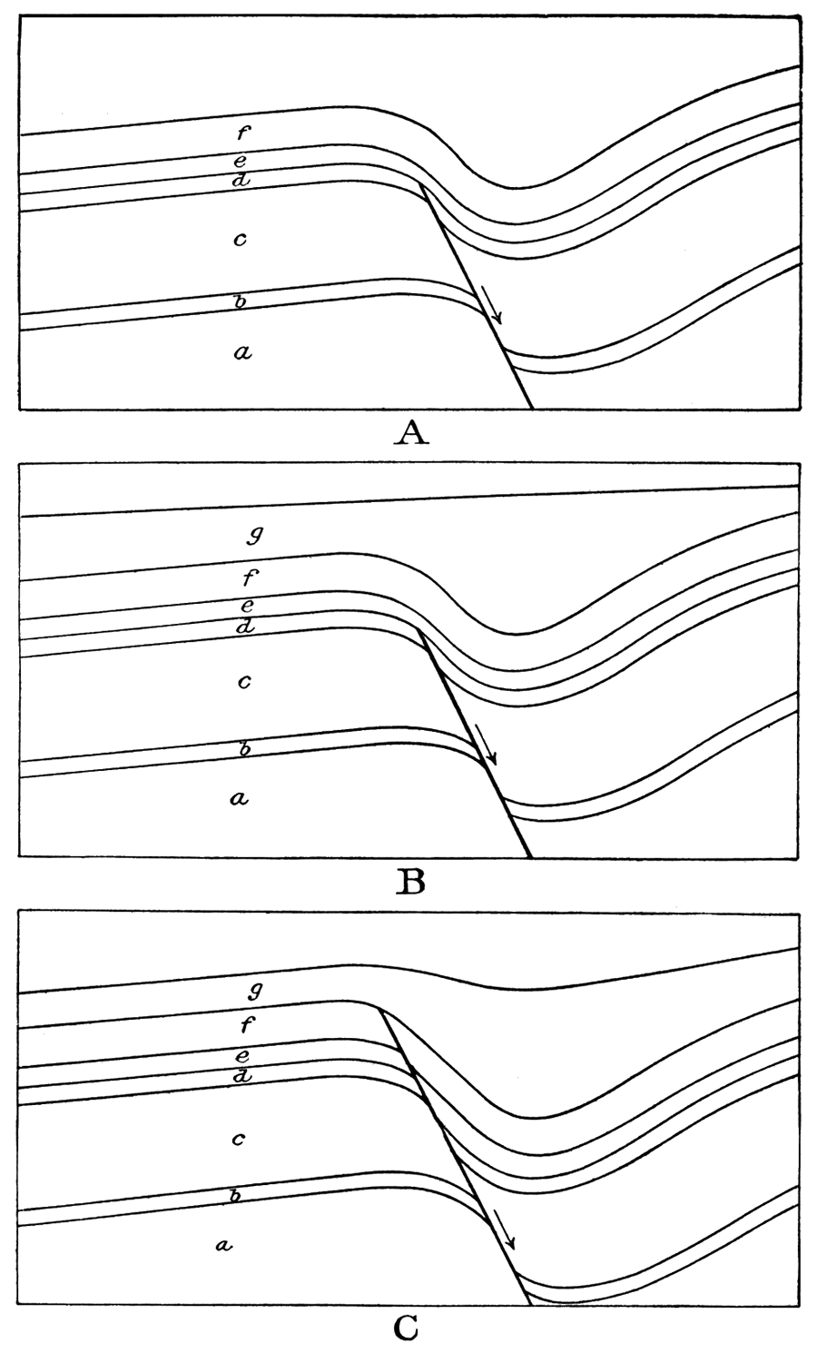
Figure 9--Diagrammatic sketches illustrating different stages in the upward dissipation of normal faults and their resolution into folding.
As discussed on page 105, there is some reason for thinking that the Stapleton zone is faulted in the Bishop syncline of the Eldorado field. The increase in the magnitude of the folding here between the surface rocks and the Stapleton is so great that if the Stapleton zone is not actually faulted the rocks a short distance below almost certainly must be. If the deeper rocks underlying the Bishop syncline are faulted there is good reason for thinking that the same rocks are more highly faulted beneath the more sharply folded Hammond syncline lying to the south, and if so, the faults extend higher up through the stratigraphic section than beneath the Bishop syncline. North of the Bishop syncline is the Fowler syncline, and in this structure the folding is less intense, but this also increases with depth. (See plate XIV.) If this finally gives place to a fault at greater depths, the fracture probably would not come so near to the surface as those in the Bishop syncline and Hammond syncline localities.
It is to be noted that the Hammond and Bishop and Fowler synclines lie in line with each other, as if related to some tectonic line or fault in the granitic basement. To produce these structures, according to the author's views, the displacement on the fault must have varied from place. to place.
The possibility of faulting in the Stapleton zone on the southeast flank of the Koogler nose is also suggested by the evidence in hand. (See page 108.)
The steeply dipping east flanks of the Koogler nose and the Boyer, Oil Hill and Chesney domes, which form the west limb of the Walnut syncline, well shown by the surface rock structure, are in line with each other, and if continued farther north would about extend to the east flank of the Robinson dome. The same alignment is more marked in the Stapleton zone by the much steeper east dips on the above structures, which if continued northward would extend into the diminishing syncline in the E2, sec. 3, T. 25 S., R. 5 E., which separates the Robinson dome from the one possibly present in the Stapleton zone to the east. To the writer this alignment appears to represent another tectonic line whose expression increases with depth, and at depths greater than the Stapleton should be marked by a fault in the granitic basement.
Although the anticlines of the Eldorado field seem to the author to be intimately related to faults with vertical throw in the basement rocks, the general subject may receive a broader consideration. Carrying this reasoning further, the question arises, Do the anticlinal folds of the northern Midcontinent region as a whole indicate vertical displacements along extensive master faults or shear zones in the basement rocks comparable to those which, by horizontal movements, are believed to have produced the belts of en echelon faults of northeastern Oklahoma, some of which have lengths of 50 miles or more.
The "granite ridge" belt of folding, which includes at the south the anticlines of the Eldorado, Augusta and Douglas fields, reaches nearly across the state of Kansas. Other extensive lines of flexing have been mapped in Kay, Garfield, Noble, Creek and Osage counties, Oklahoma, and in Cowley county, Kansas, and their distribution and trend is shown on a single map in plate XIV, U. S. Geological Survey, Professional Paper 128-C; 1920. Extensive lines of flexing are also shown in Osage county, Oklahoma. [Heald, K. C., 1916, plate 11; Heald, 1919, pl. XIII; Heald and others, 1922, various plates.] Some of these anticlines are not only in general parallel to the hypothetical deep-seated horizontal faults which caused the belts of en echelon surf ace faults, but are also equally extensive. This parallelism and coextensiveness point to a close, if not common, relation in origin. All the anticlines in the Midcontinent field cannot, however, be pointed out in support of this hypothesis, for many small ones, including many in Osage county, Oklahoma, do not lend themselves so readily to this explanation, and still others may be wholly due to other causes.
If some of the belts of folding are due to vertical displacements along master faults or shear zones in the basement rocks, the displacement along any such fault would probably not be of equal magnitude throughout its entire extent. The result in the surface rocks of such a deep-seated displacement would not be a single continuous and uniform anticline, but would probably be more or less local in extent. A 100-foot displacement at any one place might disappear within a short distance and the resulting anticline in the overlying beds would have definite termini. The length of such an anticline is a measure not of the extent of the fault or shear zone, but merely of the distance along its course through which noticeable vertical displacement has taken place. There may have been vertical displacements at intervals along these lines or zones of weakness, forming a long linear series of anticlines in the surface rocks, such as those in the beds overlying the buried "granite ridge," which extends practically, if not entirely, across the state of Kansas, and in the subparallel belts of short anticlines such as those of Osage county, Oklahoma. An excellent example in the Eldorado field is to be found in the Hammond-Bishop-Fowler line of depression, where, although located along a single tectonic line, these features are each distinct, and appear to be of decreasing intensity, the Hammond syncline at the south being strongly developed, whereas the Fowler syncline at the north is but slightly developed, and the Bishop syncline lying between is intermediate in its development. It may be possible that where these displacements die out rapidly in both directions the resultant folding in the overlying sediments will not be elongated into an anticline, but will assume the more local form of a dome if buckling in the bedded rocks attended the vertical movement in the basement rocks. The domes on the major Eldorado anticline may be due to locally greater vertical displacements along these master faults in the basement rocks.
To form the extensive systems of anticlinal, synclinal and fault belts of the northern Midcontinent oil and gas field, it is believed by the author that a regional series of essentially parallel master faults or shear zones should be present in the basement rocks. Two such appear to be present in the Eldorado field, one of which, as previously mentioned, follows the east flank of the Shumway dome and its southward prolongation, the Whitewater nose. The other follows in general the east flanks of the Koogler nose, the Boyer, Oil Hill and Chesney domes (the Walnut syncline), and appears, according to the structure in the Stapleton zone, to terminate in the vicinity of the Robinson dome. The displacement may merely diminish here and farther north increase again. Other more local faults, probably trending in transverse directions, should be present to account for such features as the Chelsea and Wilson domes.
Such parallel faults or shear zones of regional extent and large displacement are not uncommon in the basement rocks exposed in the surrounding region. They were formed, however, only during great orogenic disturbances, and no deformation of this magnitude has taken place, so far as known since the beginning of Paleozoic time in the vicinity of the northern Midcontinent region, as evidenced by the rocks exposed in the surrounding region, so the faults or zones of weakness postulated as present in the basement rocks of this region probably originated in pre-Cambrian times. It is possible that these faults or shear zones were formed originally either by thrust faulting or normal faulting; but whatever their origin, it is believed that the later displacements along these ancient lines which caused the faulting and dip reversals in the Pennsylvanian and Permian strata of the northern Midcontinent region represent merely a renewed movement along these ancient fault planes.
As discussed on pages 81 and 82 and pages 85 and 86, slight deformational movements incident to the Ozark uplift occurred intermittently in this region since Mississippian times. If the parallel system of fault planes in the basement rocks existed throughout this time, these intermittent movements probably took place along these zones of weakness. The lower Pennsylvanian strata may therefore have been involved in movements, presumably along the faults, prior to the deposition of the overlying higher beds. If such movements occurred at repeated intervals, the lowermost beds would have been involved in numerous deformations and the successively higher beds in correspondingly fewer deformations. This would result in the lower beds being more folded or faulted than the higher beds, and it is therefore possible that folds and faults exist in the deeper Pennsylvanian strata which have no corresponding structure in the surface rocks, which were deposited after the particular movement took place. This theoretical condition is illustrated in B of figure 9, and examples of its existence are believed to be exhibited in the folded pay rock of the Smock and Sluss pools and in the following features in the Stapleton oil zone: the Ralston syncline in sec. 36, T. 25 S., R. 4 E.; the probable fault in sec. 27, T. 25 S., R. 5 E.; the syncline in sec. 3, T. 25 S., R. 5 E., and the possible dome in sec. 2, T. 25 S., R. 5 E.; the double apex on the Wilson dome, the wrinkled crest of the Shumway dome, and other features of lesser development.
As the kind of structure in the surface rocks is determined by the nature of the latest movement along the fault planes in the old rocks, which occurred since these surface rocks were deposited, according to the theory here presented, other types of structure may occur in deeper lying rocks along the same fault plane. Thus en echelon faults, due to horizontal displacements in early Pennsylvanian times, may exist in the deeper rocks, while a vertical movement in post-Permian times along the same fault would produce folding in the surface rocks. Of such a nature may be the faults in the Stapleton sand in secs. 27 and 34, T. 25 S., R. 5 E., as described on page 248. Further, a combination of horizontal and vertical displacements, whether of the same or of different age, may produce both faulting and folding. Numerous occurrences of such combined types of structure are known, such as the Catfish anticlines of the Bristow quadrangle, Oklahoma, and many others in Osage county of the same state.
Where several movements have occurred along a fault, some of these displacements may have been in opposite directions and compensated each other, with the result that a lower bed would show less displacement or folding than a higher bed. Such a reversal of movement along an otherwise normal fault is indicated in the faults near Paden, Oklahoma (Fath, A. E., and Heald, 1917, pp. 358 and 359).
That slight and intermittent deformational movements occurred in this region since Mississippian times is quite clearly confirmed by the results of drilling in the oil and gas fields located on anticlinal folds. In the Eldorado field this is exceedingly well shown by comparing the spacing of the contours for the different horizons on plates I and XIV and figures 3 and 4. This increase of dip for the successively lower horizons is given below in tabular form.
The increase in amount of folding with depth, as shown in this table, is regular throughout the field with the exception of the Boyer dome. Here the amount of closure with depth decreases, but in this connection closure alone must not be considered as the only criterion. It is believed that the east dip in the Stapleton zone would, if sufficient drilling information were available, show ratios in dip to the surface rocks similar to those on the other domes. This condition obtains not only in the Eldorado field, but is also indicated in the Cushing oil field in Oklahoma (Beal, 1917, p. 21-35) where intervals of deformation are indicated through a 2,600-foot series of sediments. The following table, compiled from the structure maps of Beal's report, shows this increasing amount of folding from the surface downward to the Bartlesville sand. The greater folding with depth is extremely well shown with the exception of the discrepancy between the Wheeler and Layton sands on the Mount Pleasant and Shamrock domes. The cause of this discrepancy is not clear. A not altogether plausible explanation is a pre-Layton local reversing movement similar to but far more highly developed than that indicated at Paden (Fath, A. E., and Heald, 1917, pp. 358 and 359).8 The increase in amount of folding between the surface rocks and the Layton sand is most marked.
| Table showing by amount of closure in feet and relative increase in dip the increased amount of folding with depth in the Eldorado field | ||||||||||||
|---|---|---|---|---|---|---|---|---|---|---|---|---|
| Shumway dome | Boyer dome |
Koogler nose |
Oil Hill dome | Chesney dome | Wilson | Robinson dome | ||||||
| Closure, feet |
Ratio of dip between crest near SW cor. sec. 1 to base of Fowler syncline. | Closure, feet |
Ratio of dip between NE cor. 19 and W4 corner sec. 30. | Closure, feet |
Ratio of dip between apex and E4 cor. sec. 33. | Closure, feet |
Ratio of dip between SW cor. and the SE cor. SW SE sec. 22. | Closure, feet |
Ratio of dip between center and SE cor. sec. 9. | Closure, feet |
Ratio of dip between center and E4 cor. sec. 3. | |
| Surface rocks | 30 | 1 | 50 | 1 | 30 | 1 | 20 | 1 | 40 | 1 | 20 | 1 |
| 660-foot oil | 50 | 40 | 60+ | |||||||||
| 900-foot gas "sand" | 40 | |||||||||||
| 1,275-foot "sand" | 50+ | |||||||||||
| Stapleton oil zone | 60*-140 | 4 | 10 | 3 1/2 | 80 | 4 1/2 | 80+ | 1 3-3 | 100+ | 4 | 70 | 5 |
| *The Boyer dome is of negligible importance in the Stapleton zone, and hence 140 feet should be considered the closure on the Shumway in contrast to 80 feet on the Oil Hill dome. | ||||||||||||
| Table showing, by amount of closure in feet, the increased amount of folding with depth in Cushing oil and gas field. |
||||
|---|---|---|---|---|
| Dropright dome |
Drumright dome (as distinct from Mt. Pleasant dome) |
Mt. Pleasant dome (as distinct from Shamrock dome) |
Shamrock dome |
|
| Surface rocks | 75-100 | 15-25 | 50-75 | 75-100 |
| Layton sand (1,350 feet deep) | 175-200 | 15-25 | 300-325 | 250-275 |
| Wheeler sand (2,100 feet deep) | 200-225 | 25-50 | 250-275 | 100-125 |
| Bartlesville sand (2,150 feet deep) | 200-250 | 50-75 | 275-300 | 175--200 |
This increased amount of folding with depth, and therefore the possibility that well-developed folds exist in oil-bearing sands without any corresponding flexure in the surface rocks, is of great economic significance. Oil and gas may accumulate in such places where there is little or no folding in the surface rocks—a condition which cannot be determined by structural geologic investigations in advance of prospecting, as in the Smock-Sluss pool and probably many other of the smaller Midcontinent pools in localities where the rocks at the surface show no favorable structure. It is to be pointed out, therefore, that the absence of anticlinal folding in the surface rocks does not absolutely condemn any locality for its oil and gas prospects.
The explanation of the origin of the anticlines and synclines of the northern Midcontinent oil and gas field given in the preceding pages does not account for all of their attendant phenomena, but it is believed, nevertheless, that for some it does account for a considerable part of the causes which formed them, while for others it may not apply to all. Some of the principal features which are not accounted for in this explanation are: (1) The distinct down buckling of the strata on the east sides of the postulated deep-lying faults instead of their simple dropping, and thereby the simple reversing of the dip of the strata. (2) The apparent complete absence of evidence showing that any of the vertical displacements along the postulated deep-seated faults or shear zones were sufficiently large to break entirely through the sedimentary rocks and show at the surface as a fault. This is particularly striking along the "granite ridge" where the overlying sediments are comparatively thin, less than 1,000 feet in places, and in which the movement was sufficient to cause reversed dips for 200 feet or more vertically. (3) The divergence of some of the anticlinal and domal axes from the supposed direction of the governing deep-seated fault zone, such as the Wilson and Chelsea domes of the Eldorado field. (4) The secondary or east-west relation of many of the folds in Osage county, Oklahoma, shown on plate XVIII.
Origin of the Buried "Granite Ridge" of Kansas
As the "granite ridge," which is described on pages 25-27, parallels the general trend of the anticlinal folds and the belts of en echelon faults, and as the "granite ridge" is intimately related to one of the belts of folding, it would seem that this buried feature must have an origin similar to these surface features. It would appear to have been caused by a larger vertical movement along one of the hypothetical faults or lines of weakness in the basement rocks, which raised the block on one side of the fault sufficiently high to form an island during a portion of Pennsylvanian time when the seas covered most of the rest of this general region.
If the "granite ridge" was due to such vertical faulting, and if the flexing of the surface rocks of this region was similarly due to vertical movements along, faults in the basement rocks, as postulated by the writer, then the anticlines in the Permian strata overlying the "granite ridge" indicates that slight vertical movement took place along these fault planes as late as post-Marion times of the Permian. Although this late movement is small, attention is here called to it to show that the "granite ridge" as now known was not due to a single movement, but has been in different stages of development for a long period of time. The initial and major movement in the formation of the "granite ridge" probably occurred in prePennsylvanian time. The relation of the Pennsylvanian strata to the "ridge" clearly shows that it was an island during a portion of Pennsylvanian time. In the Eldorado field the relation of the Cherokee shale to the Stapleton oil zone indicates that there was some movement along the "granite ridge" belt of folding in pre-Cherokee times, and it is probable that this was merely a part of the intermittent later developments similar to the post-Marion development mentioned above.
The time interval between the Boone and the deposition of the Cherokee was an extensive period of erosion of considerable duration (Snider, 1915), and it is possible that the major development of the "ridge" took place during this time. There is some evidence, however, that the ridge was slightly developed even in Mississippian times.
The general lack of clastic material in the Mississippian strata of eastern Kansas, although not positive evidence, nevertheless favors the contention of both R. C. Moore (1918, p. 105, 106) and the writer (Fath, 1920, p. 83) that the ridge was not an elevated land mass during Boone times. The presence, however, locally of clastic sediments, principally sand, in the pre-Boone rocks of the Eldorado region would appear to require the presence of a near-by land mass to supply a source for the material from which they are made. If such a land mass was the source of the material in the sandy pre-Boone strata of the Eldorado region, then the absence of similar material throughout eastern Kansas would indicate the land probably to have been both low in elevation and small in extent. From this evidence it would appear that the "granite ridge" may have been at least partly developed in pre-Boone times.
In resume it may be stated that the age of the buried "granite ridge" of Kansas probably represents a mass of the granitic basement uplifted above its general level by faulting. Its formation probably took place not in a single major displacement at one time, but in small increments occurring intermittently during a long period, extending perhaps from pre-Mississippian to post-Permian times, with its greatest development during the post-Mississippian erosion interval.
The "granite well" in Riley county, Kansas, may indicate the presence of a second buried "granite ridge" which may parallel the one described above. Granite was also encountered in Woodson county, Kansas, at a depth of 2,585 feet, which is 1,045 feet below the bottom of the Pennsylvanian rocks. See log D on plate VII. It is possible that the total thickness of Cambrian, Ordovician and Mississippian rocks in this general region is only 1,045 feet, or, if not, another buried granite ridge may be located here.
Summary of Conclusions as to Origin of Midcontinent Types of Structure
The parallelism of the fault belts, anticlinal and synclinal folds and the buried "granite ridge" of the northern Midcontinent oil- and gas-field region points to a common relationship in origin. The faults, by their character and grouping, furnish the best evidence of this common cause by indicating definite lines of weakness and movement, not in the weak strata in which they are found, but probably in the strong rocks of the basement complex. Nearly horizontal movements along these lines of weakness in the deep-lying rocks, with the consequent drag of the overlying weak sediments, would tear the lower parts of these sediments along a narrow belt parallel to the movement, and short fractures would open which would trend diagonally with the direction of the deep-seated movements. The adjustment of the overlying weak strata to these fractures would result in the belts of short normal faults characteristic of the region.
Vertical displacement along these same lines of weakness in the basement rocks would produce folds in the overlying Paleozoic sediments parallel to the lines of faulting, and some of the anticlinal and synclinal folds of the Midcontinent field exhibit considerable evidence that they were so formed. Other folds cannot be so readily explained, and still others probably were wholly formed by other causes.
Of special economic importance is the fact that deeply buried oil- and gas-bearing sands are generally more flexed into anticlines, domes and synclines than are the surface rocks, and hence that in places the oil- and gas-bearing strata are folded and control the accumulation of oil and gas into pools without the surface rocks being noticeably deformed.
The buried "granite ridge" of Kansas may be similarly explained as a large vertical displacement which took place in intermittent increments extending from Mississippian to postPermian times along one of the lines of weakness in the basement rocks.
Original Source of Oil and Gas
The origin of the structural features which determine the location of the oil and gas in the Eldorado field has been tentatively explained. There was considerable evidence upon which the explanation rested. The origin of the hydrocarbons, however, and the location of their source is not so clear. No direct evidence for the solution of these problems has been obtained, but some indirect evidence is at hand, and this will be briefly summarized.
It is very generally believed among geologists that oil and gas are derived through the slow distillation of carbonaceous material in sediments, principally shales, subjected to high pressure beneath overlying rock formations. In the Eldorado section, given on plate VI, the apparent absence of shales below the Stapleton oil zone as a source of the oil in this zone is to be noted.
In the apparent absence of an original source or mother rock below the Stapleton, which is probably the most appropriate location to be expected, since any circulation of fluids is more generally surfaceward, the strata which overlap the flanks of the folded erosion surface are to be considered. Here, as indicated in the sections on plate VIII and in figure 1, are to be found the Cherokee shales in the lowermost parts of the Pennsylvanian series, which in the oil fields farther east in Kansas and in northeastern Oklahoma contain most of the oil-producing beds, and which possibly may even here represent the source of the Stapleton oil. The movement necessary for oil and gas formed in these beds to reach the Stapleton oil zone is principally lateral, but at the same time is slightly upward, as is not improbable in oil and gas migration.
The higher shales overlying the Stapleton pay rock, those of the Henrietta and Pleasanton groups, could also have been the source, possibly in part only, in which case the migration of the petroleum from these beds must have been in part stratigraphically downward-a less likely possibility.
The source of the oil and gas for the higher pays is more readily explained by the greater abundance of shales with which they are closely associated.
Prev Page--Chelsea Dome || Next Page--Character of oil and gas
Kansas Geological Survey, Geology
Placed on web July 28, 2017; originally published 1921.
Comments to webadmin@kgs.ku.edu
The URL for this page is http://www.kgs.ku.edu/Publications/Bulletins/7/10_anti.html