![]()
Prev Page--History || Next Page--Structure
Stratigraphy
General Features
The stratigraphy of eastern Kansas in comparison to that of most regions is simple, the various formations being remarkably uniform in character throughout the state. The rocks range in age from pre-Cambrian to Permian, and their sequence and relative thicknesses, as compiled from measurements made on the outcrops of the various formations, are graphically represented in plate VI. This section, which is typical for eastern Kansas, will be compared with the Eldorado section as determined from surface and drill-record study, which is shown in plate VI. [Note: The 900-foot, 1,485-foot, Boyer and Stokes "sands" are not recorded in the three logs shown on plate VI, hence their stratigrapliie locations are indicated at the right by the words "position of ——."]
In the following discussion it must be borne in mind that much of the evidence has been obtained from well records, and as the use of well records in correlating strata from place to place in the Midcontinent field is uncertain even at its best, the discussion must contain possibilities of error. This is more particularly true in the correlation of the formations encountered by drilling in the Eldorado field with the outcropping rocks to the east, because access was not had to all the inf ormation that could be desired. Nevertheless it is considered that the evidence and discussion which follow are close approximations of the facts.
Unexposed Rocks
Pre-Cambrian Rocks
Rocks of undoubted pre-Cambrian age, such as granites and quartzites, crop out at numerous places around the borders of the Midcontinent oil and gas field—in the St. Francis mountains of southeastern Missouri; the Arbuckle and Wichita mountains of southern Oklahoma; the Rocky Mountains of New Mexico, Colorado, and Wyoming; the Black Hills in southwestern South Dakota; and in the Sioux quartzite area of southeastern South Dakota, southwestern Minnesota, and northwestern Iowa. These outcrops probably do not represent rocks of precisely the same age, but they all represent ancient basement rocks upon which all the Paleozoic stratified rocks of the Midcontinent region were deposited. Similar crystalline rocks are known in Kansas, but unlike the localities mentioned above, their presence is known only through wells drilled for oil, which were located principally on a belt of anticlines regarded as favorable for oil (Taylor, 1917; Powers, 1917; Wright, 1917; Moore and Haynes, 1917, pp. 140-173; Moore, 1918). (See plate III.) It is to be noted that one of these wells is located in the Eldorado field. With the single exception of the Eldorado field, all the so-called "granite well" localities have been proved barren of oil.
The "granite wells" on this belt of anticlines are located intermittently from southern Nebraska, south-southwestward across two-thirds of Kansas, and into the Eldorado field. The folding continues beyond the Eldorado field and includes the anticlines of the Augusta (McDowell, 1917, map on p. 294) and Douglas fields, which probably extend as far as, if not into, Cowley county.
The crystalline basement thus encountered is much shallower than had previously been thought possible. The depths at which these wells entered the crystalline rocks range from 500 feet (575 feet above sea level) in the Bern well in Pawnee county, southern Nebraska, to 2,715 feet on the Shumway lease in the NE, sec. 11, T. 26 S., R. 4 E., of the Eldorado field (Personal communication to the U. S. Geological Survey from Mr. Geo. C. Matson, chief geologist for the Gypsy Oil Company). The rocks overlying the granite in the wells north of the Eldorado field are probably of Pennsylvanian age, whereas those in the Eldorado field are of Mississippian or even earlier age, as will be indicated further on. To the east of this linear series of "granite wells" other drill holes of greater depth did not encounter the crystalline rocks, indicating that the pre-Cambrian in this bordering region lies much deeper. There is reason to believe that the same condition applies also to the west side of this series of wells, although one well near Winkler, in Riley county, Kansas, penetrated the crystalline rocks at a depth of 2,385 feet. These conditions taken together point to a buried crystalline mountain range extending from Pawnee county, Nebraska, southward into Butler county, Kansas, which has been termed the Nemaha mountains (Moore and Haynes, 1917, pp. 141-145). The relation in origin between this buried "granite ridge" and the belt of anticlines associated with it, which extends farther south across the state and includes those of the Eldorado and Augusta fields, is of considerable practical and theoretical importance, the nature of which is brought out more fully on pages 148-166. It may be mentioned, however, that the "granite ridge" probably continues south-southwestward beyond the Eldorado field, in which direction it should lie at increasingly greater depths beneath the belt of anticlinal folding. The crystalline-rock well near Winkler, in northern Riley county, may indicate another range to the west of the Nemaha range, with a valley between.
Crystalline rocks have also been encountered in the eastern part of the state, near Paola and Yates Center, but there appears to be no evidence indicating these occurrences to represent buried mountain ranges, but rather that they represent the normal pre-Cambrian basement on which the Paleozoic sediments were deposited.
Cambrian and Ordovician Rocks
The rocks of Cambrian and Ordovician age outcropping in southwestern Missouri consist of a thick series, 1,000-2,200 feet, of massive dolomites and sandstones. These extend westward and pass beneath the surface into Kansas, where they are known only through well records. It is probable that these strata are, at least in part, represented by the deeper known rocks encountered by drilling in the Eldorado field. Their differentiation here, however, is not clear.
Beneath the limestone portion of the Stapleton oil zone which is of Mississippian (Boone) age, is a thick and apparently massive series of sandstones, which on the Shumway lease, in sec. 11, T. 26 S., R. 4 E., as before mentioned, was penetrated and the granite encountered at a depth of but 2,715 feet. Only three or four miles away, however, in secs. 29 and 30, T. 25 S., R. 5 E., wells have penetrated this series for more than 1,000 feet, to a depth of 3,700 feet (2,300 feet below sea level), without reaching the granite. (See Eldorado well logs in plate VI.) Drill records report limestone for a part of this, but the writer has been informed that I this is erroneous and that it is practically all sandstone (Oral communication from Mr. A. W. McCoy, geologist for the Empire Gas and Fuel Company, who has had access to a very great number of drill cuttings.).
This great thickness of sandstone is in large part, if not altogether, of pre-Mississippian age. If the upper part of it is Mississippian, the dividing line between the Mississippian and underlying strata is not clear. In view of this lack of differentiation it seems reasonable for present purposes tentatively to consider this great thickness of sandstone to be older than Mississippian and to correlate it with the Ordovician and Cambrian of the Missouri section.
[Note: Here and there in southwestern Missouri and northeastern Oklahoma the Devonian and Silurian rocks are only slightly developed. Their presence in Kansas, however, has not been well demonstrated, and hence no attempt has been made to correlate any part of the Eldorado section with these rock systems. Another viewpoint of this thick sandstone series can be had by considering it to be of early Mississippian (pre-Boone) age. Its lithology on this basis could be accounted for through the relation of the Eldorado region to the bnried "granite ridge" by postulating that the ridge existed prior to Boone times and that the material of this sandstone series which borders it was derived through its degradation by erosion. In this explanation, however, the ridge must have been greatly reduced in size by erosion and then partly submerged prior to the deposition of the Boone limestone.]
This sandstone series diminishes in thickness to the north-northeast of the Eldorado field in the direction of the "granite ridge" belt of folding, and very probably is not represented in the Covey "granite well" in sec. 26, T. 23 S., R. 5 E., only 6 miles north of the area described in this report. It should, however, extend northward both to the east and to the west of this buried ridge.
Mississippian Rocks
General Consideration
The Mississippian rocks of the northern Midcontinent field have received a great deal of attention from the oil industry, since in this series lie the lowest known oil-producing horizons of this region. [Note—Recent subsurface studies and new information obtained in northern Oklahoma and southern Kansas indicate that producing horizons in these fields belong in part to the Ordovician. See Aurin, Clark and Trager, "Notes on the subsurface pre-Pennsylvanian stratigraphy of the northern Midcontinent oil fields," Am. Assoc. Petroleum Geologists, Bull., vol. 5, pp. 117-153, 1921. State Geologist.] Where higher formations are not oil bearing, the top of the Mississippian has usually been considered the last chance for obtaining production, and where this too is barren, deeper drilling is generally abandoned.
The Mississippian rocks crop out in Missouri, the southeastern corner of Kansas, and northeastern Oklahoma, and consist of 300 to 350 feet of cherty limestone, which has been termed the Boone limestone. Drillers and oil operators, however, often speak of it as the "Mississippi lime" or the Boone chert.
By the use of well records after the manner shown in plate VII, the Boone formation has been traced westward as far as Butler county and its surface through eastern Kansas contoured with considerable accuracy by Moore and Haynes (1917, pl. XXV). The westernmost contours of Moore and Haynes' map extend into the Eldorado region and indicate the top of the Mississippian to lie about 1,800 feet below sea level, or at a depth of about 3,200 feet. These westernmost contours are probably extrapolations which were based principally on the apparent regular westerly dip prevalent to the east of the Eldorado district, and which took no account of the flexure in the deep-lying Mississippian rocks in this field, that raises these rocks hundreds of feet nearer to the surface. Only a part of this rise is apparent in the less strongly folded surface rocks, and the remainder is accounted for by a local thinning of the formations overlying the Mississippian on the crest of the anticline. This will be pointed out on a later page from the evidence presented by well logs.
In the Eldorado field the prolific oil-producing Stapleton pay zone lies at the top of a thick series of rocks, principally sandstones, below a shale which is the lowest shale in this general locality. This relation is similar to that of the Boone limestone in Greenwood and Woodson counties to the east (logs D to H in plate VII), where its presence is sufficiently well known so that the top of the Boone and the thickness of the overlying Cherokee shale can be contoured (Moore and Haynes, 1917, pl. XXV; Berger, 1918). Well-record correlations between these areas and the Eldorado field indicate the Stapleton pay zone, as shown at the right in plate VI, to be at the top of the pre-Pennsylvanian rocks, or in the same relative position as the Boone. A study of plate VII and the sections G and H of plate VIII, which are a direct continuation thereof, brings this relation out very clearly. In addition to this stratigraphic relation the Stapleton is largely a cherty limestone (see description on pp. 30-36), the same as the Boone, and this lithologic similarity, together with its similarity in stratigraphic position, seems to the writer to constitute sufficient evidence for correlating the limestone portion of the Stapleton with the Boone. If this correlation be correct the configuration of the upper surface of the Mississippian rocks in the Eldorado field is the same as that of the top of the Stapleton oil zone as given on plate 1. The thickness of the Mississippian rocks in the Eldorado region will be brought out in the discussions of the Stapleton oil zone.
Stapleton Oil Zone
The deep and productive Stapleton oil zone of the Eldorado field, which obtains its name from the Stapleton lease in sec. 29, T. 25 S., R. 5 E., where it was discovered, is believed by the writer to be a special phase of the pre-Pennsylvanian rocks (it may include more than the Mississippian), which, because of its importance in the production of oil, deserves special consideration. Further, its lithology differs so from place to place that an interpretation based on this variation must be made.
The mineral character of this pay varies greatly, from cherty dolomitic limestone through shale to sandstone composed of well-rounded quartz grains. The shale beds, which probably lie interbedded with the limestone, are in general thin, and their distribution is dependent upon the extent to which the post-Mississippian erosion period affected them. The diversity in composition of the Stapleton pay zone is indicated by the following detailed descriptions of drill cuttings, obtained from wells rather widely scattered in the Eldorado field:
| Empire Gas and Fuel Company's Cardey Well No. 7. (Northeast corner location in NW SE, sec. 11, T. 26 S., R. 4 E.) Top of sand at 2,333 feet. |
||
|---|---|---|
| Depth of sample, feet. |
Material of sample. | Interpretation of sample. |
| 2,329-2,330 | Shale, light to dark gray; calcareous. | Shale, gray, calcareous. |
| 2,330-2,346 | No samples. | |
| 2,346-2,352 | Limestone, tan to gray in color, dolomitic; and shale, black. | Limestone, tan to gray in color, dolomitic; with a few interbedded thin shales, dark gray. |
| 2,352-2,355 | Limestone, tan to gray in color, dolomitic; with a little shale, dark gray. | |
| 2,355-2,356 | Limestone, tan to gray in color, dolomitic; with a little shale, dark gray. | |
| 2,356-2,360 | Limestone, gray, dolomitic; with considerable shale, dark gray. | Limestone, gray, dolomitic; with a few interbedded thin shales, dark gray. |
| 2,360-2,363 | Limestone, gray, dolomitic; with considerable shale, dark gray. | |
| 2,363-2,366 | Limestone, gray, dolomitic; with considerable shale, dark gray. | |
| 2,366-2,368 | Limestone, gray, dolomitic; with some shale, dark gray. | |
| 2,368-2,370 | No sample. | |
| 2,370-2,372 | Limestone, gray, dolomitic, with but very little shale. | Limestone, gray, dolomitic, slightly cherty; and a few interbedded thin shales, dark gray. |
| 2,372-2,375 | Limestone, light gray, dolomitic. | |
| 2,375-2,377 | Limestone, light gray, dolomitic; with some shale, black; and a very little chert. | |
| Empire Gas and Fuel Company's Paulson Well No. 3. (Center location along north line of NW NE, sec. 2, T. 26 S., R. 4 E.) Top of sand at 2,350 feet. |
||
|---|---|---|
| Depth of sample, feet. |
Material of sample. | Interpretation of sample. |
| 2,348-2,350 | Shale, dark gray in color; and, limestone, dolomitic, gray; with considerable chert. | Shale, dark gray. |
| 2,350-2,357 | Principally chert, but also limestone, dolomitic, gray; and some shale, dark gray. | Limestone, very cherty, gray; with a few interbedded thin shales, dark gray. |
| 2,357-2,363 | Principally chert; with a little limestone, dolomitic, gray colored; and some shale, dark gray. | |
| 2,363-2,368 | Limestone, dolomitic, tan; with some chert. | Limestone, dolomitic, cherty, tan to gray. |
| 2,368-2,374 | Limestone, dolomitic, gray. | |
| 2,374-2,381 | Limestone, dolomitic, tan; with some chert. | |
| 2,381-2,387 | Limestone, dolomitic, gray; with some chert. | |
| 2,387-2,392 | Limestone, dolomitic, gray; with some chert. | |
| 2,392-2,398 | Limestone, dolomitic, tan. | |
| 2,398-2,402 | Limestone, dolomitic, tan; with a little chert. | |
| 2,402-2,406 | Limestone, dolomitic, tan; with a little chert, and some shale, dark gray. | Limestone, dolomitic, cherty, tan; with a few interbedded thin shales, dark gray. |
| 2,406-2,407 | Limestone, dolomitic, tan; with a little chert, and some shale, dark gray. | |
| 2,407-2,409 | Limestone, dolomitic, tan; with a little chert. | Limestone, dolomitic, cherty, gray to tan. |
| 2,409-2,411 | Limestone, dolomitic, gray; with much chert. | |
| 2,411-2,414 | Limestone, dolomitic, gray; with some chert. | |
| 2,414-2,418 | Limestone, dolomitic, gray; with some chert. | |
| Empire Gas and Fuel Company's Tague Well No. 1. (Northeast corner location SE NE, sec. 13, T. 2 6 S., R. 4 E.) Top sand at 2,448 feet. |
||
|---|---|---|
| Depth of sample, feet. |
Material of sample. | Interpretation of sample. |
| (?)-2,448 | Shale, bluish gray; and limestone, light gray, with some chert. | Shale, bluish-gray; with gray cherty limestone at base. |
| 2,448-2,457 | No sample. | |
| 2,457-2,464 | Quartz sand, fine grained, fairly well rounded. | Sandstone, medium grained. |
| 2,464-2,469 | Quartz sand, fine grained, fairly well rounded. | |
| 2,469-2,474 | Quartz sand, medium grained, grains well rounded. | |
| 2,474-2,480 | Quartz sand, medium grained, grains well rounded. | |
| 2,480-2,483 | Quartz sand, medium grained, grains well rounded. | |
| 2,483-2,488 | Quartz sand, medium grained, grains well rounded. | |
| 2,488-2,492 | Quartzitic sand, medium grained; with considerable shale, dark gray. | Sandstone, with a few interbedded thin shales, dark gray. |
| 2,492-2,497 | Quartzitic sand, medium grained; with considerable shale, dark gray. | |
| Empire Gas and Fuel Company's Huston Well No. 1. (Southeast corner location in SW, sec. 19, T. 26 S., R. 5 E.) Top sand at 2,610 feet. |
||
|---|---|---|
| Depth of sample, feet. |
Material of sample. | Interpretation of sample. |
| 2,605-2,610 | Shale, dark gray; but principally limestone, dolomitic, tan. | Shale, dark gray; with limestone, dolomitic, gray at base. |
| 2,610-2,615 | Limestone, dolomitic, gray. | Limestone, dolomitic, gray. |
| 2,615-2,619 | Limestone, dolomitic, gray. | |
| 2,619-2,625 | Limestone, dolomitic, gray; with a little quartzitic sand. | |
| 2,625-2,630 | Quartzitic sand, medium grained; with a little limestone, dolomitic, gray. | Quartzitic sandstone, medium grained. |
| 2,630-2,635 | Quartzitic sand, medium grained, grains well rounded. | |
| 2,635-2,640 | Quartzitic sand, medium grained, grains well rounded. | |
| Empire Gas and Fuel Company's Barnhill Well No. 9. (Southeast corner location NW, sec. 6, T. 26 S., R. 5 E.) Top of sand at 2,449 feet. |
||
|---|---|---|
| Depth of sample, feet. |
Material of sample. | Interpretation of sample. |
| 2,449-2,451 | Principally chert; with limestone, dolomitic, gray; and some shale, dark gray. | Limestone, dolomitic, cherty, gray. |
| 2,451-2,455 | Limestone, dolomitic, gray; with considerable chert. | |
| 2,455-2,461 | Limestone, dolomitic, gray; with a little chert. | |
| 2,461-2,466 | Limestone, dolomitic, gray. | |
| 2,466-2,471 | Limestone, dolomitic, gray; with a little chert. | |
| 2,471-2,476 | Limestone, gray. | |
| 2,476-2,482 | Limestone, dolomitic, gray. | |
| Empire Gas and Fuel Company's Fulkerson Well No. 6. (Northeast corner location NW, sec. 4, T. 26 S., R. 5 E.) Top of sand at 2,523 feet. |
||
|---|---|---|
| Depth of sample, feet. |
Material of sample. | Interpretation of sample. |
| 2,523-2,528 | Limestone, dolomitic, tan. | Limestone, slightly cherty, tan to gray in color. |
| 2,528-2,533 | Limestone, dolomitic, tan; with a little shale and a trace of chert. | |
| 2,533-2,538 | Limestone, tan; with a trace of chert. | |
| 2,538-2,548 | Limestone, tan; and a little quartzitic sand, grains well rounded. | Sandstone. |
| 2,548-2,554 | Quartzitic sand, medium grained; grains well rounded. | |
| Empire Gas and Fuel Company's Knox Well No. 22. (Center location along south line of SE, NW, sec. 15, T. 25 S., R. 5 E.) Top of sand at 2,507 feet. |
||
|---|---|---|
| Depth of sample, feet. |
Material of sample. | Interpretation of sample. |
| 2,507-2,523 (?) | No sample. | |
| 2,523(?)-2,526 | Limestone, dolomitic, tan; with a little black shale. | Limestone, dolomitic, gray; with a few interbedded thin shales, dark gray. |
| 2,526-2,527 | Limestone, dolomitic, tan; with considerable shale, dark gray. | |
| 2,527-2,530 | Limestone, dolomitic, gray to tan; with some shale, dark gray. | |
| 2,530-2,535 | Limestone, dolomitic, gray to tan. | |
| 2,535-2,540 | Limestone, dolomitic, gray to tan; with some shale, dark gray. | |
| 2,540-2,544 | Limestone, dolomitic, gray to tan. | Limestone, dolomitic, gray. |
| 2,544-2,549 | Limestone, dolomitic, gray to tan. | |
| Empire Gas and Fuel Company's Wilson Well No. 55. (Southeast corner location NE NW, sec. 8, T. 25 S., R. 5 E.) Top of sand at 2,443 feet. |
||
|---|---|---|
| Depth of sample, feet. |
Material of sample. | Interpretation of sample. |
| 2,334-2,445 | Shale, gray to black; with considerable quartzitic sand and some cherty conglomeratic pebbles. | Shale, gray to black. |
| 2,445-2,448 | Shale, gray to black; and sand, medium grained. | |
| 2,448-2,453 | Quartzitic sand; and shale, dark gray. | Sandstone, medium grained; interbedded with several thin beds of shale, dark gray. |
| 2,453-2,458 | Quartzitic sand; with some shale and a little chert. | |
| 2,458-2,463 | Quartzitic sand, medium grained, grains well rounded; with a little shale, dark gray. | |
| 2,463-2,468 | Quartzitic sand, medium grained, grains well rounded. | |
| Empire Gas and Fuel Company's Wilson Well No. 60. (Center location along north side of NE, sec. 8, T. 25 S., R. 5 E.) Top of sand at 2,475 feet. |
||
|---|---|---|
| Depth of sample, feet. |
Material of sample. | Interpretation of sample. |
| (?)-2,475 | Shale, dark bluish-gray; with a little limestone, dolomitic, gray to tan. | Shale, dark gray. |
| 2,475-2,481 | Limestone, tan; with some shale, dark gray. | Limestone, dolomitic, slightly cherty, interbedded with a few thin shales, dark gray. |
| 2,481-2,487 | Limestone, tan; with some shale, dark gray. | |
| 2,487-2,493 | Limestone, dolomitic, tan; with a very little chert. | |
| 2,493-2,499 | Limestone, dolomitic, gray to tan; with much shale, dark gray. | |
The variation in composition from cherty limestone, through shale, to sandstone is both horizontal and vertical, or geographic and stratigraphic. Drill cuttings of the Stapleton oil zone were obtained from forty-nine wells scattered rather widely over the field, but on detailed examination it was found that this number was insufficient from which to make any definite statement concerning the geographic and stratigraphic distribution of the limestone, shale and sandstone composing it. It seems, however, that the oil zone over much of the Koogler nose is composed principally of well-rounded quartz sand, whereas over much of the remaining part of the field it alternates more between limestone and sand, with the limestone predominating.
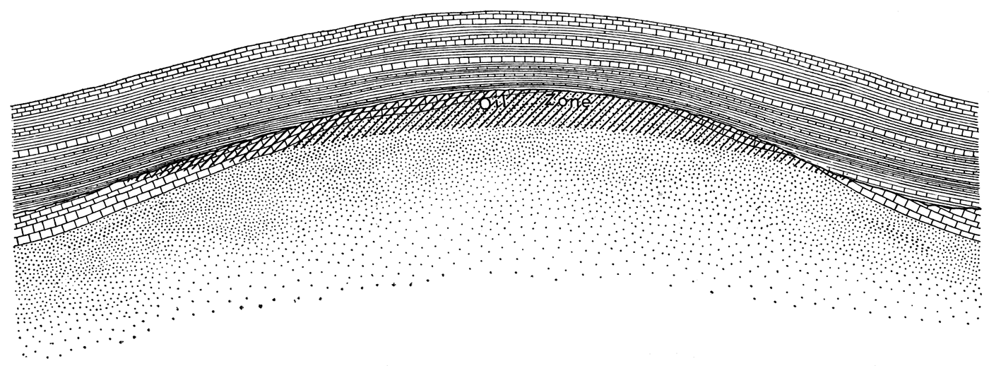
This variation in composition may possibly be due to purely geographic distribution of material in the same stratigraphic interval, as believed by some, but the author believes that a more plausible interpretation may be found in considering the Stapleton oil zone to be not a stratigraphic unit, but the dissected upper portion of the pre-Pennsylvanian rocks which suffered a period of erosion prior to the deposition of the Pennsylvanian sediments. This interpretation of the Stapleton zone is diagrammatically illustrated in figure 1. The top of this zone in the Eldorado field would thus be a peneplained surface with little relief, which since its dissection in post-Mississippian times has been warped into the attitude of an anticline. The limestone portions of the Stapleton zone may, therefore, be interpreted as remnants of the Boone limestone, and the sandstone portions as rocks of pre-Boone age. The thickness of the Mississippian rocks, on this basis, is indicated in the developed part of the field by the thickness of the limestone portions of the Stapleton oil zone. Where both limestone and sandstone are recorded in the well logs the limestone overlies the sandstone, in full agreement with this interpretation. Information pertaining to the thickness of the limestone in the area bordering the field proper was available from but one well log, shown graphically as J on plate VII. In the absence of drill cuttings from this well it is impossible to judge whether the limestone begins at 2,711 or at 2,806 feet; and depending on this, the Boone, according to the log, is either 402 or 307 feet thick, for at 3,113 feet the drill is reported to have passed from limestone into a soft formation logged as shale, and after 82 feet of this into sand for 18 feet. Drilling continued beyond this depth, 3,213 feet, but the log below this point was not available.
Figure 1—Diagrammatic sketch showing an oil zone which crosses the bedding of the rocks in which is is contained.
In the hope that fossil evidence would assist in establishing the age of the Stapleton zone, a microscopic examination was made of its drill cuttings from several wells for remains of microscopic organisms, but no determinable forms were found.
The Stapleton oil zone, according to the above interpretation of the author, and the interpretation which will be implied throughout the text, is not a stratigraphic unit, but instead is merely that portion of the Mississippian, and possibly pre-Mississippian, strata which is or might be oil-bearing. For this reason the term "sand," which is usually interpreted as an oil-bearing stratigraphic unit, has been substituted by "zone," a term which is more accurately descriptive.
Inasmuch as the author does not consider the Stapleton oil zone to be a stratigraphic unit, the concept of its thickness must be limited to the thickness of the pay rock where it is oil-bearing. Where not oil-bearing the Stapleton zone must be regarded simply as the upper part of the older rocks. The thickness of the oil-bearing portion probably varies greatly from place to place in the field, in some parts of the field within very short distances, especially where the oil follows some definite porous bed, and this bed dips at an angle with the top of the eroded Stapleton surface. The entire thickness of the Stapleton zone can be determined in but few places, since in wells the drilling is almost invariably stopped before passing through the oil zone. The thickness, therefore, cannot in general be determined closer than by the number of feet the oil zone is penetrated. Interest in the thickness of the oil-bearing zone centers principally in ascertaining the thickness of the reservoir rocks. On the Shumway dome the penetration of the Stapleton oil zone ranges in general from 35 to 65 feet. A few wells have penetrated as much as 90 feet, whereas others entered the Stapleton zone as little as 4 or 5 feet. The amount of penetration appears to be determined principally by the depth where the greatest flow of oil can be obtained. As an example, the Gypsy Oil Company's Shumway well No. 13, which was drilled in with a 17,000-barrel production, penetrated the Stapleton zone only 6 feet (see log on pp. 103-104), whereas the Carter Oil Company's Orban well No. 1, less than 2,000 feet distant, penetrated 60 feet before its production reached 10,000 barrels.
On the Boyer dome the penetration is in general greater, ranging principally between 50 and 80 feet, with exceptional ones reaching more than 100 feet. On the Koogler nose of this structure, where quartz sand appears to constitute most of the pay rock, the penetration in general ranges between 10 and25feet. On the Oil Hill dome the range averaged between 20 and 50 feet, with a few penetrating more than 80 feet into the sand. The range of penetration on the Chesney dome is greater, from 20 to 80 feet; and on the Wilson dome from 20 to 40 feet. The Robinson dome in this respect is very similar to the Wilson dome, most of the wells being drilled into the sand between 15 and 40 feet. The amount of penetration in certain areas is graphically shown on plate VIII.
Pennsylvanian Rocks
Cherokee Shale and Marmaton Formation
[Note: The divisions of the Pennsylvanian and Permian referred to in this report as "formations," in accordance with the usage of the Kansas Geological Survey in its reports, are at present considered as stratigraphic "groups" by the United States Geological Survey where applied to rocks in Kansas.]
Overlying the Stapleton oil zone and in the interval between it and the Kansas City formation, which in eastern Kansas is occupied by the Cherokee shale [named after Cherokee county, Kansas, Haworth and Kirk, 1894] and the Marmaton formation, is a variable thickness of shale with interbedded thin limestones. On the crest of the Eldorado anticline this shale and limestone series measures about 250 feet, but on the flank it thickens rapidly, in one place to as much as 650 feet. (See the graphic Eldorado logs on plate VI, and sections on plate VIII.) Its thickness probably increases to beyond this amount, but the drilling information is not sufficiently satisfactory for accurate determinations. This variation in thickness from place to place is probably due to the early Pennsylvanian sediments in this region overlapping a previously formed anticlinal ridge in the Mississippian rocks.
In eastern Kansas the oldest formation of Pennsylvanian age is the Cherokee shale, which contains many of the oil sands of the northern Midcontinent field. Berger (1918) has shown by his study of well records and drill cuttings that this formation thins in going west from Labette county to Butler county, and that because of the thinning and probable elimination of the Fort Scott limestone in eastern Butler county it so merges with the rocks of the overlying Marmaton formation that the two cannot be accurately differentiated farther west. This undoubtedly is the condition as the Eldorado field is approached. If the Cherokee shale continues to thin in Butler county at about the same rate as it does to the east of it, as shown by Berger (1918) it should be about 200 feet thick in the region immediately east of the Eldorado anticline. Whether it pinches out on reaching the flanks of the anticline, or whether it continues on over the crest by a relatively greater thinning in conjunction with a thinning of the overlying Marmaton formation, cannot, it is obvious, be ascertained from well-record information only. At any rate, the Cherokee probably reaches the Eldorado region in the Walnut syncline, where, as on the flanks of the anticline, it forms a part of the interval between the Stapleton oil zone and the Kansas City formation. It may be entirely absent on the crest of the anticline, and if present it must be thin.
The Marmaton formation in its outcropping area in eastern Kansas is composed of several distinct limestone and shale members. To the west these members gradually lose their identify, and by the time they reach the Eldorado field they no longer be differentiated. It is apparent that over the crest of the Eldorado anticline the thickness of the Marmaton is thinner than at the outcrop, even though it embraces most 0f the 250 feet of shale and thin limestone overlying the Stapleton oil zone on the crest of the anticline.
Kansas City Formation
[Note: Named after Kansas City, Mo. Hinds and Greene, 1915, p. 28.]
The strata overlying the Marmaton formation can be correlated somewhat more readily by means of well records with their outcropping equivalents in eastern Kansas. Although the formations as a whole can be differentiated with considerable accuracy, the individual members have changed sufficiently and merged with each other to such an extent that they do not, as a rule, stand out as distinct units in the well records. Probably the most uniformly recorded beds in all the Eldorado well logs are two thick limestones separated by a thick shale, which altogether comprise about 500 feet of rocks lying approximately between 1,700 and 2,300 feet below the top of the Fort Riley limestone. These lithologic units which comprise the Kansas City and Lansing formations are differentiated in plate VI and the cross sections on plate VIII. The lowermost of these three lithologic units is believed to be the local representative of the Kansas City formation, which here, as well as in Greenwood county, as represented by the logs in plate VII, is less subdivided than in the region of its outcrop, as shown in plate VI—a feature which probably indicates that the Eldorado and Greenwood county localities were nearer the center of the depositional basin in which these strata were formed. In this connection it may be pointed out that the deep portion of the Cherokee basin, as interpreted by Berger (1918), lies along a line from Labette county, Kansas, to Rogers county, Oklahoma. In like manner the thickest portion of the overlying Fort Scott limestone of the Marmaton formation lies farther west, in northeastern Osage county, Oklahoma, and southeastern Chautauqua county, Kansas, or west of the deeper portion of the Cherokee basin. The more calcareous nature of the Kansas City formation in the Greenwood county and Eldorado localities, which lie still farther west, suggests a continued westward shifting of the successive depositional basins.
It is to be noted that the Stokes "sand," which is producing pay in three wells near the east quarter corner, sec. 33, T. 25 S., R. 5 E. (marked as miscellaneous wells on plate I), and found at a depth of about 2,000 feet is a part of the limestone here correlated with the Kansas City formation. No drill cuttings of this "sand" were obtained; hence the driller's interpretation which designates it "sand" represents the only information concerning its lithology which can be supplied in this report.
Lansing Formation
[Note: Named after Lansing, Leavenworth county, Kansas. Hinds and Greene, 1915, p. 28.]
Overlying the beds correlated with the Kansas City formation in most of the logs of the Eldorado wells is a comparatively thick shale, followed by another limestone similar in thickness to the limestone representing the Kansas City formation. Some few logs record "sand" between the shale and limestone, as in plate VI, but in general this is not mentioned. The shale probably is the equivalent of the Lane shale and the limestone the equivalent of the Plattsburg, Vilas and Stanton members, all of which belong to the Lansing formation.
The Kansas City formation as previously mentioned, is more calcareous in the Greenwood county and Eldorado localities than in the region of its outcrop, and so also is the Lansing formation, indicating that the Lansing basin was equally as far west as the earlier Kansas City depositional basin.
Douglas Formation
[Note: Named after Douglas county, Kansas. Haworth, 1898, p. 93.]
Overlying the thick shale and two limestones representing the Lansing and Kansas City formations are 200 to 250 feet of shale with a few thin limestone and sandstone members. These are correlated with the Douglas formation. The Oread limestone, at the top of the Douglas, is not positively identified, but the limestones in the Eldorado section (plate VI), lying between 11395 and 1,490 feet below the top of the Fort Riley limestone are considered by the writer to be its approximate equivalent. These are the limestones that contain the 1,475-foot gas "sand." The Boyer "sand," which lithologically is a limestone, occurs in the lower part of the Douglas formation and may be considered to belong to the Weston shale.
Shawnee Formation
[Note: Named after Shawnee county, Kansas. Haworth, 1898, p. 93-94.]
The overlying rocks in the Eldorado field that are correlated with the Shawnee formation consist of a thick series of interbedded limestones and shales, with the limestones predominating. The shale at the top of this division is believed to be the Scranton shale. The rocks as a whole are more calcareous than the Shawnee at its outcrop, and in addition are also more calcareous than in Greenwood county, a feature which is brought out by comparing the well records in plates VI and VII. This westward increase in the quantity of limestone in the rocks of this interval indicates that the Eldorado region was nearer to the center of the general Shawnee depositional basin than the area to the east. This would seem to indicate a still farther westward migration of the depositional basin since Kansas City time.
This suggested westward shifting of the depositional basins for the successive groups indicates a gradual elevation in some center lying to the east, probably the Ozark uplift. It further indicates that concurrent with the deposition of these Pennsylvanian rocks slight deformational movements occurred, a feature which will be taken into consideration in explaining, on pp. 160-163, the greater flexing of the deeper rocks than the surface formations in the Eldorado field.
The Shawnee formations contains the 900-foot, 1,125-foot, 1,200-foot and 1,275-foot gas "sands," but since the various formations cannot be differentiated, no close correlations can be made for the different producing "pays."
Wabaunsee Formation
[Note: Named after Wabaunsee county, Kansas. Prosser, 1895, pp. 682-705 and 764-800; 1895.]
Immediately above the Scranton (?) shale is a thin limestone, which is believed to be the Burlingame limestone, at the base of the Wabaunsee formation. This is followed by about 210 feet of shale, which probably represents the Willard and Admire shales, the intervening Emporia limestone not being recognized in the well records. The importance of this thick shale lies in the fact that it contains the two shallow oil sands of the Eldorado field. Following this shale are several limestones and shales which probably are the equivalents of the Americus limestone, Elmdale formation, Neva limestone, and Eskridge shale, the latter forming the top of the Wabaunsee formation, and probably the top of the Pennsylvanian in eastern Kansas.
Permian Rocks
Council Grove Formation
[Note: Named after Council Grove, Morris county, Kansas. Prosser, 1902, p. 716.]
There is no stratigraphic break between the Pennsylvanian and Permian systems in this part of Kansas; deposition appears to have been continuous from one period to the other. Because of the transitional nature of the upper Pennsylvanian and the lower Permian strata, the dividing line between the two is difficult to determine. According to the present classification of the United States and Kansas Geological surveys the line is drawn at the base of the Cottonwood limestone, the basal member of the Council Grove formation and a well-defined bed which has been mapped across the entire state of Kansas (Haworth, 1908, pls. VII, a, b, c).
A limestone, apparently persistent in the Eldorado field, is found about 400 feet below the top of the Fort Riley limestone, but according to the writer's interpretation this is more likely to be the Neva limestone, which is near the top of the underlying Wabaunsee formation. Besides the Cottonwood limestone, the Council Grove formation includes the Garrison member, a comparatively thick calcareous shale containing numerous thin limestone beds. Because of its "Shelly" nature, its interpretation by drillers varies from limestone, through shells," to shale.
Chase Formation
[Note: 7. Named after Chase county, Kansas. Prosser, 1902 pp. 713-714.]
The next higher subdivision of the Permian is the Chase formation, the two basal members of which—the Wreford limestone (named after Wreford, Geary county, Kansas. Hay, 1893.) and the Matfield shale—are not exposed in the Eldorado field. The Wreford is a persistent stratigraphic unit very generally recorded in the well records. In many records this limestone is masqued by its flinty character, which because of its cutting effect on the bit, and water-bearing character, appears to have been interpreted by many drillers as sand.
In the Flint Hills escarpment and along the Missouri Pacific right of way, about 16 miles east of Eldorado, the Wreford forms a rather conspicuous ledge. It consists for the most part of cherty limestone and thin calcareous shales, which, as measured by the writer, total about 28 feet in thickness. [Note: For a more detailed description see Beede and Sellards, 1905.]
The Matfield shale is the highest unexposed stratigraphic unit in the Eldorado field (named after Matfield, Chase county, Kansas. Prosser, 1902, p. 718, diagram). Really its upper portion, although not seen, may be present beneath a cover of soil and detritus washed down from the overlying rocks in the bottoms of the deeper valleys in secs. 20 and 17, T. 26 S., R. 5 E. Its outcrop, however, may be observed in the Flint Hills escarpment about 16 miles east of Eldorado and along the Missouri Pacific right of way, where it consists of maroon, bluish and yellowish calcareous shales and a few thin light-gray limestone beds, having a total thickness of about 57 feet (for a more detailed description see Beede and Sellards, 1905, pp. 96-100). In the well logs of the Eldorado field the Matfield is not always recorded with any great degree of uniformity. It is usually logged as "shale," and the thickness recorded varies from 45 to 75 feet.
Exposed Rocks
Introductory Statement
But two classes of rock-limestone and shale, together with their intergradations-comprise the exposed rocks in the Eldorado field, and of these nine distinct stratigraphic units were recognized and mapped. As shown in plate VI, they all belong to but two formations-the Chase and Marion, of the Permian system. Those at the bottom, up to and including the Winfield, belong in the Chase formation, and the higher ones belong in the Marion formation. Several of these units, because they are difficult to erode, are prominent in the surface topography of the region.
Permian Rocks
Chase Formation
Florence Flint
[Note: Named after Florence, Marion county, Kansas. Prosser, C. S., 1895, p. 773.]
The lower part of the exposed Eldorado section consists of a limestone which measures 80 to 90 or more feet in thickness. The lower part of this limestone is characterized by its abundant content of chert, and thereby differs noticeably from the upper portion which contains no chert whatever. This two-fold character is uniformly persistent over wide areas and has permitted a division of the limestone into two distinct units-the lower flinty or chert-bearing portion, being appropriately termed the Florence flint; and the upper, more calcareous portion, the Fort Riley limestone.
The maximum exposed thickness of the Florence flint in the Eldorado field is in the south bank of the creek near the center of sec. 20, T. 26 S., R. 5 E., where it measures 35 feet. Its base was not observed in the Eldorado district, but its complete thickness probably does not greatly exceed 35 feet. This thickness is greater by 7 or more feet than at the type locality at Florence, 35 miles north of Eldorado, where its complete thickness, 27 feet, is shown in the face of a quarry about half a mile northeast of the town, along the McPherson branch of the Santa Fe railroad.
The upper boundary of the Florence flint is not marked by any topographic feature in the Eldorado district, but is defined merely by the upper limit of the chert. The dominant character of the Florence member is its flint, or as it may be termed preferably, its chert content, which comprises about 20 per cent of the rock and occurs as chert beds and bands of chert nodules rather uniformly interbedded with the limestone. The chert beds have characteristic nodular surfaces (see plate IX, A), and commonly range from 2 to 6 or 8 inches in thickness. The chert weathers to a rusty color, and on such surfaces it generally shows in relief innumerable fragmentary fossil remains, principally Bryozoa.
Plate IX—A, Exposure of the Florence flint, showing its chert-bearing character.
Because of its greater resistance to weathering, the chert is present as residual material in many places where there are no exposures of the Florence. By this evidence the areal distribution of the Florence is indicated in many localities. Where the chert is not noticeable on the surface of the ground it is buried in the soil, and digging will generally disclose its presence. Pipe-line ditches and sludge pits or other excavations were thus of great help in disclosing the distribution of the Florence, and not only was its general areal extent indicated, but by noting where the chert ceased it was possible without natural exposures to determine closely the contact between the Florence flint and the overlying Fort Riley limestone.
The limestone of the Florence is nearly white and appears slightly granular in texture, although some layers, particularly near the bottom, are light gray and compact. The weathered surface is usually more or less gray. On the whole, however, there is no general distinctive difference between any parts of the Florence, either in the character of limestone or of the chert, or even in the distribution of the chert within the limestone. There is no color distinction between the limestone of the Florence and the lower part of the Fort Riley. The fauna of the Florence flint, according to Dr. George H. Girty, is clearly not distinctive. In a few places thin layers were observed which were made up largely of the coral Lonsdaleia ? n. sp. The following list is a representative collection of forms gathered from several places throughout the field and identified by Doctor Girty:
| Productus calhounianus ? Productus cora ? Lonsdaleia ? n. sp. Myalina wyomingensis ? Deltopecten occidentalis |
Fort Riley Limestone
[Note: Named after Fort Riley, Geary county, Kansas. Swallow, p. 14, 1866.]
The Fort Riley limestone is in several respects the most important stratigraphic unit in the Eldorado field. It is the surface rock throughout much of the producing area, and in many places the ground surface conforms closely to the top of this formation. It is thus more intimately related than any other unit to the determination of the structure, and because of this close relationship its upper surface is the key horizon used in this report for representing the structure of the outcropping rocks.
The Fort Riley as a whole is well exposed in but few places, though good exposures of its various divisions can be found at numerous places. It shows variations both in character and thickness, and ranges from whitish through yellowish-white to bluish-gray. In thickness it ranges from 44 feet along the Walnut river in sec. 8, T. 25, R. 6, to 55 or 56 feet in the SE, sec. 22, T. 26, R. 5. Throughout most of the field a threefold division in character is recognizable—a lower massively bedded portion; a middle thinly bedded or shaly portion; and an upper massively bedded portion. The characteristics of these subdivisions are indicated in the following generalized section:
| Generalized section of the Fort Riley limestone in the Eldorado field. | Thickness, feet |
||
|---|---|---|---|
| Doyle shale. | |||
| Fort Riley limestone | |||
| Upper massively bedded division | |||
| Limestone, massively bedded; whitish to light gray; ranging from oolitic, through a characteristic minutely honeycombed, to a compact texture; weathering on level surfaces to boulder-like masses; fossiliferous | 0-25 | ||
| Middle thinly bedded division | |||
| Limestone, thin-bedded, light gray to bluish-gray; in most cases compact; interbedded with shale, calcareous; greenish gray to gray; fossiliferous | 15-25 | ||
| Lower massively bedded division | |||
| Limestone, massively bedded; spotted or granular, to finely compact in texture; light to dark gray; fossiliferous | 10-21 | ||
| Florence flint | |||
As the formation varies in thickness, so each of the three divisions also vary in thickness, the upper heavy-bedded portion more than the two lower divisions. This upper portion is practically if not entirely absent in the northeast corner of the Eldorado district. It, as well as the lower massively bedded portions, each have their individual characteristics, and hence it is, in general, readily possible to determine to what part of the formation any isolated exposure may belong. These differences in character were of great value, especially in locating the contact with the underlying Florence flint at such places where exposures were poor and meager, particularly in pipeline or other excavations which but slightly uncovered the soil-buried rocks.
The base of the Fort Riley is placed just above the uppermost chert-bearing bed which represents the top of the Florence flint. The top of the Fort Riley is at the contact with the overlying Doyle shale. The lower part of this shale is in some places very limy, and may be called shaly limestone, but in such localities the topmost massively bedded limestone, with its individual characteristics, as described below, is considered the top of the Fort Riley.
The lower massive portion of the Fort Riley, which varies in thickness from 10 to 20 or more feet, is characterized by its content of small, indistinct, globular masses, which in places give it a spotted or faintly pisolitic appearance, especially on a freshly broken surface. In places these globular masses are more resistant than the embedding material, and give the rock a rough, etched appearance. The globular masses where weathered are more white or chalky than the embedding limestone, and range in size from minute grains to small masses one-fourth or one-third of an inch in diameter. In places they comprise practically the entire mass of the rock, while in other portions of the rock they are more scattered. Taken as a whole, however, the spotted or faintly pisolitic appearance is characteristic. This character is not confined exclusively to the lower part of the Fort Riley, but extends also slightly down into the chert-bearing Florence, and in such places the presence or absence of chert determines whether the rock belongs to the Fort Riley or Florence division. Because of their indistinct nature, it is rather uncertain whether the globular masses are concretionary grains or unknown organisms.
The middle division of the Fort Riley, which varies from 15 to 25 feet in thickness, is characterized by its thin and more argillaceous beds. In places limy shales form a part of this division. Because of this more argillaceous nature the exposures of this part are fewer and poorer than the overlying and underlying massively bedded parts. It is this contrast in exposure and character that so readily permits a subdivision of the Fort Riley.
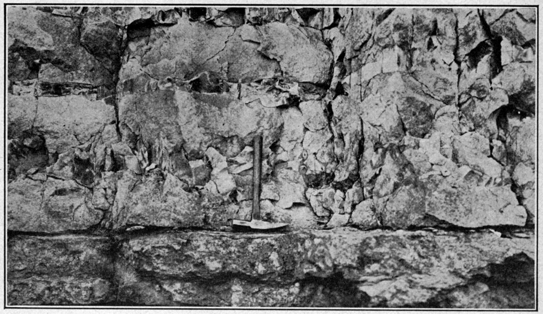
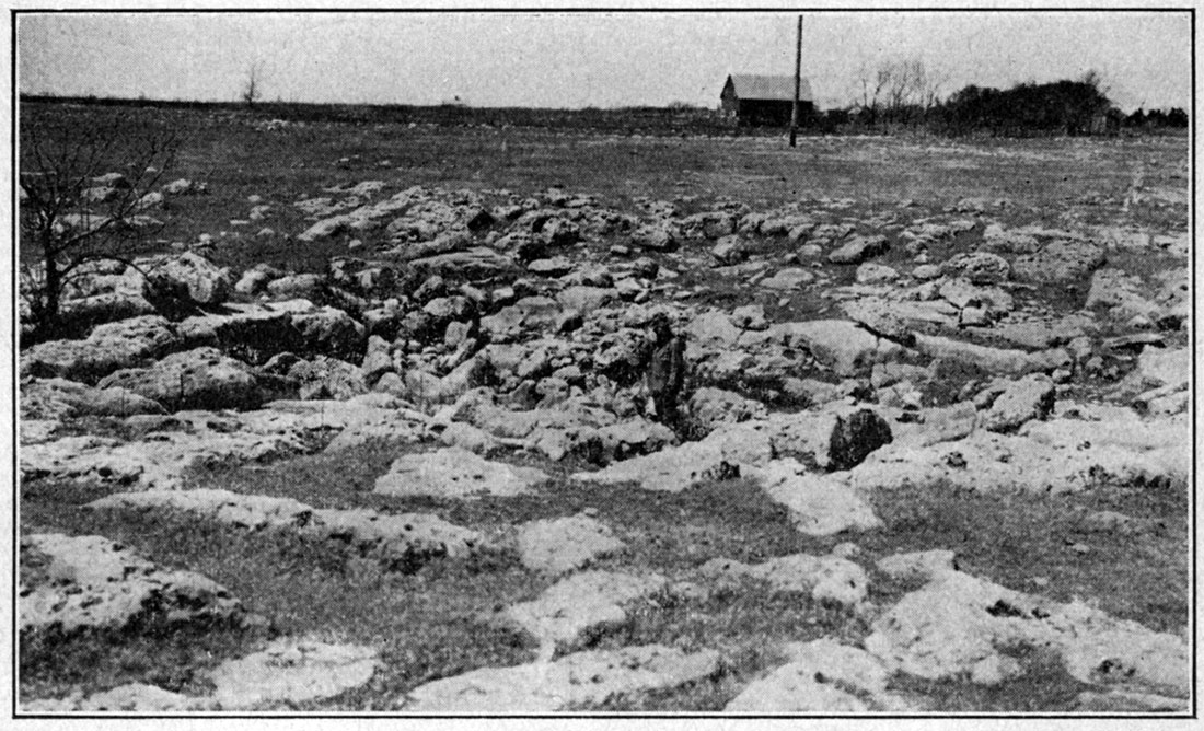
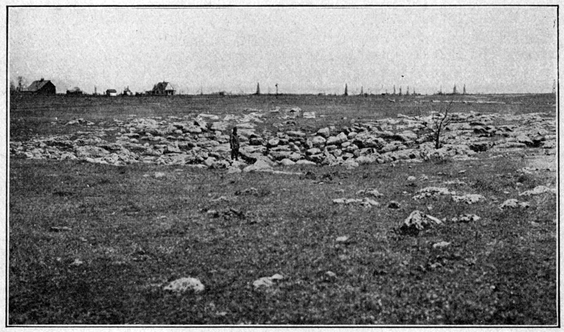
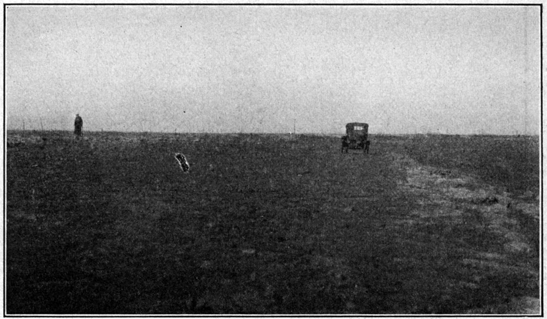
The upper massively bedded division is more picturesque in its outcrops than the lower divisions. This is indicated by plates IX, B, and X, which show its pitted boulder-like outcrop and sink-hole-forming character. These boulders cover areas hundred of acres in extent in some places, and where the ground surface is nearly horizontal they are accompanied by sink holes. Even though these major features are not present, the rock itself is characterized by its porous nature, which may be described as minutely honeycombed or finely spongelike. The cause of the porous texture was not ascertained. This honeycomb structure is not uniformly present throughout the upper part of the Fort Riley, but it is its dominant individual character. The bouldery aspect of the outcrop, so typical of the upper Fort Riley, is a weathering phenomenon in which the joint planes play an important role, permitting readier circulation for dissolving waters. As the individual blocks become smaller through solution the remnants become more isolated and the surface of the ground acquires a boulder-strewn appearance. Because this upper part is so soluble, sink holes have formed in it, especially where the surface is nearly level, for the rainfall, instead of running off, soaks through the soil into the porous limestone and through solution develops an efficient underground drainage. The depth of the sinks is probably controlled by the thickness of the upper member.
Plate IX—B, Boulder-like outcrop of the top of the Fort Riley limestone.
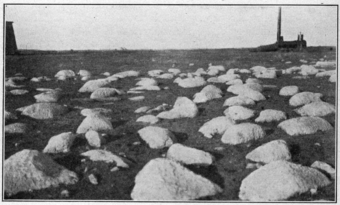
Plate X—Two views showing sink-hole development in upper division of the Fort Riley limestone.
The three divisions of the Fort Riley limestone are well differentiated in the following section west of the Sluss pool:
| Section of Fort Riley limestone exposed in north bank of small creek in the SE, sec. 22, T. 26 S., R. 5 E. | Thickness, feet |
||
|---|---|---|---|
| Doyle shale. | |||
| Fort Riley limestone | |||
| Upper division | |||
| Limestone, massive, whitish to light gray, forms 3 ledges. At places on the top of the lowermost bench a great many weathered-out fossils are present. (See fossil list on p. 53) | 25 | ||
| Middle division | |||
| Limestone, thinly bedded, light gray, more argillaceous than overlying and underlying divisions, probably interbedded with several thin beds of shale. Poorly exposed | 20 | ||
| Lower division | |||
| Limestone, massive, light gray, finely spotted and slightly pisolitic appearing | 10 | ||
| Florence flint | |||
The upper division of the Fort Riley, as previously mentioned, is entirely absent in the northeastern part of the district. This is due apparently to a thinning eastward and northward, which culminates in the valley crossing the northeastern part of section 6 and the northwestern part of sec. 5, T. 25 S., R. 6 E. The thinning is evident also in the section given below, which is exposed in the face of the Dolese Brothers' quarry, about two miles east of Eldorado and a short distance east of the area embraced by the map (plate I). The threefold division so typically exhibited throughout most of the field is not well represented in this section. The topmost bed is a part of the boulder-forming upper massive division, and may be its only representative here. Beneath this are 18 feet of the thinly bedded middle division, which is underlain by a massive bed, 6 feet 7 inches in thickness, of very fine-grained, compact limestone, which was not observed at any other place. This lower 21 feet represents the lower division.
| Section of Fort Riley limestone exposed in east face of Dolese Brothers' quarry, two miles east of Eldorado, Kan. (a short distance east of the area embraced by the map, plate I). | Thickness, | ||
|---|---|---|---|
| feet | inches | ||
| Fort Riley limestone | |||
| Limestone, stone, light gray, weathering boulder-like masses, complete thickness not shown | 2 + | ||
| Shale, poorly exposed, thickness not shown | 1 + | ||
| Limestone, thin bedded, fossiliferous | 4 | ||
| Limestone, argillaceous, gray, with a few very thin shale bands | 1 | 6 | |
| Limestone, gray, fossiliferous | 9 | ||
| Shale, very calcareous, changing horizontally to argillaceous limestone, thickness 1 ft. 6 in., to | 2 | ||
| Limestone, argillaceous, light gray, containing a few very thin shaly layers | 1 | 10 | |
| Limestone, light gray, very fossiliferous | 1 | 4 | |
| Limestone, thin bedded, light gray | 1 | ||
| Shale, calcareous, greenish gray | 5 | ||
| Limestone, thin bedded, light gray | 2 | 11 | |
| Shale, greenish gray | 7 | ||
| Limestone, light gray | 2 | ||
| Limestone, very fine grained, breaks in places with conchoidal fracture, light gray, streaked with dark bands, slightly fossiliferous | 6 | 7 | |
| Shale, calcareous, dark gray | 3 | ||
| Limestone, granular in appearance on account of its content of some inorganic or organic growth, gray to dark gray | 20 | 10 | |
| Florence flint | |||
The individual limestone layers in the above section are not constant in material, color or thickness, even within distances so small as 100 feet. In a few places shale replaces limestone and limestone replaces shale.
Besides the small globular masses that characterize the lower division, and which may be of a concretionary origin or may represent unknown organisms, the fauna of the Fort Riley, according to Doctor Girty, includes the following forms from the upper division:
| Meekella striaticostata Meekella n. sp. Composita subtilita Deltopecten ? sp. Bellerophon (Bucanopsis?) sp. |
Doyle Shale
[Note: Named after Doyle creek, Marion county, Kansas. Prosser, p. 718, 1902.]
The rocks of eastern Kansas between the Fort Riley limestone below and the Winfield limestone above have been termed the Doyle shale. In the Eldorado district the rocks of this interval include three stratigraphic units-a lower shale (in places shaly limestone), a middle limestone, and an upper shale-all three of which are shown on plate 1. In this report they will be designated as the lower shale bed, the Towanda limestone bed, and the upper shale bed.
Lower shale bed. The lower shale bed varies little from 35 feet in thickness. It is poorly resistant to erosion, in contrast to the underlying Fort Riley limestone, and therefore is generally represented on the surface by a grassy slope back from the boulder-like upper limit of that division. Its character is shown in but few exposures, and in these considerable variation appears. Along the east side of the area mapped, the lower 20 to 25 feet is made up of light-colored calcareous shale, with several thin beds of argillaceous limestone, while the upper 10 to 15 feet is greenish shale. In contrast to this, its character in the western part of the field is much more limy. In places the lower 20 to 25 feet is altogether thin-bedded, shaly limestone with overlying shale, while in one locality along the creek crossing the SW, sec. 26, and the SE, sec. 27-25-4, this thin-bedded limestone appears to comprise the entire thickness of the lower portion of the Doyle shale.
Along the east side of the region the lower portion of the lower shale bed is partly exposed along the small stream in the W2 SE, sec. 18-25-6, and the overlying greenish shale is exposed below the Towanda limestone escarpment near the center of NE, sec. 32-24-6. No fossils were observed in this part of the stratigraphic section.
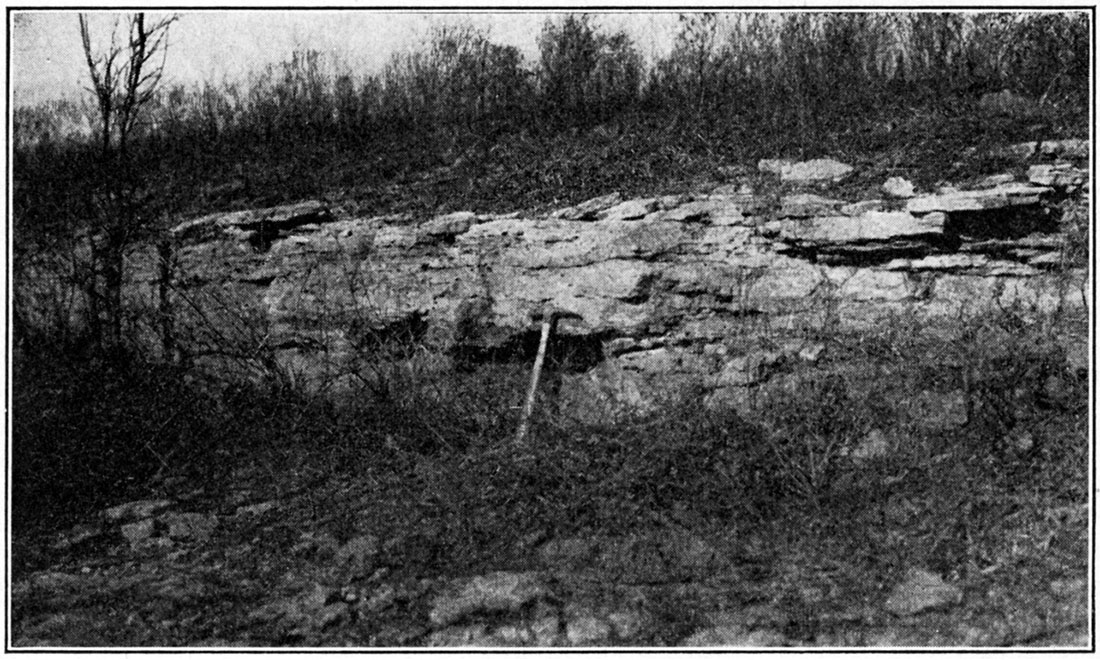
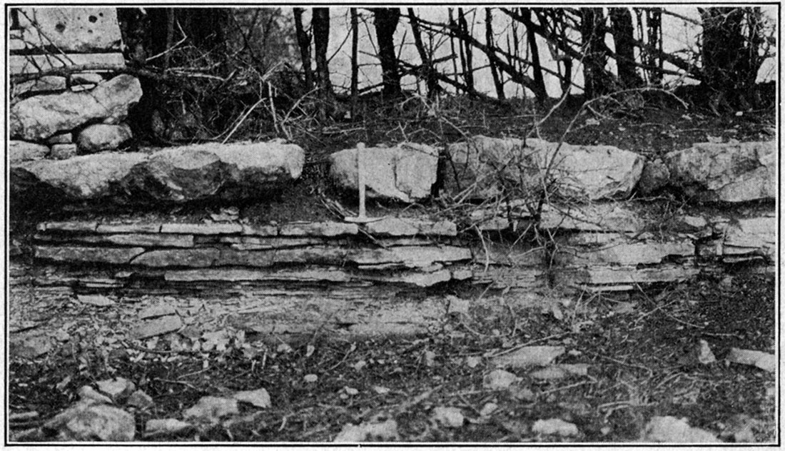
Towanda limestone bed. This limestone is bluish-gray, slabby in character, and measures from 5 to 9 1/2 feet in thickness. It is named after Towanda, where it is well exposed in the escarpment along the northwest side of this town and for a mile or more to the north. In places it crops out as a prominent ledge and forms low escarpments (see plate XI, A), as at its type locality, but throughout much of the field it is poorly exposed and its presence is indicated merely by small, thin, smooth-faced residual slabs or plates of drab-colored limestone. Its areal distribution, therefore, is not everywhere clearly defined, and this difference in definition of outcrop from place to place is roughly indicated on plate I by different symbols-a solid line where clearly defined and a dashed line where its boundary is uncertain.
The dominant characteristics of the Towanda limestone are its bluish-gray or drab color and its thin-bedded, platy or slabby nature. (See plate XI, B.) Weathering, as indicated by residual material, gives the broken fragments smooth rounded surfaces.
Plate XI—A, Escarpment formed by Towanda limestone.
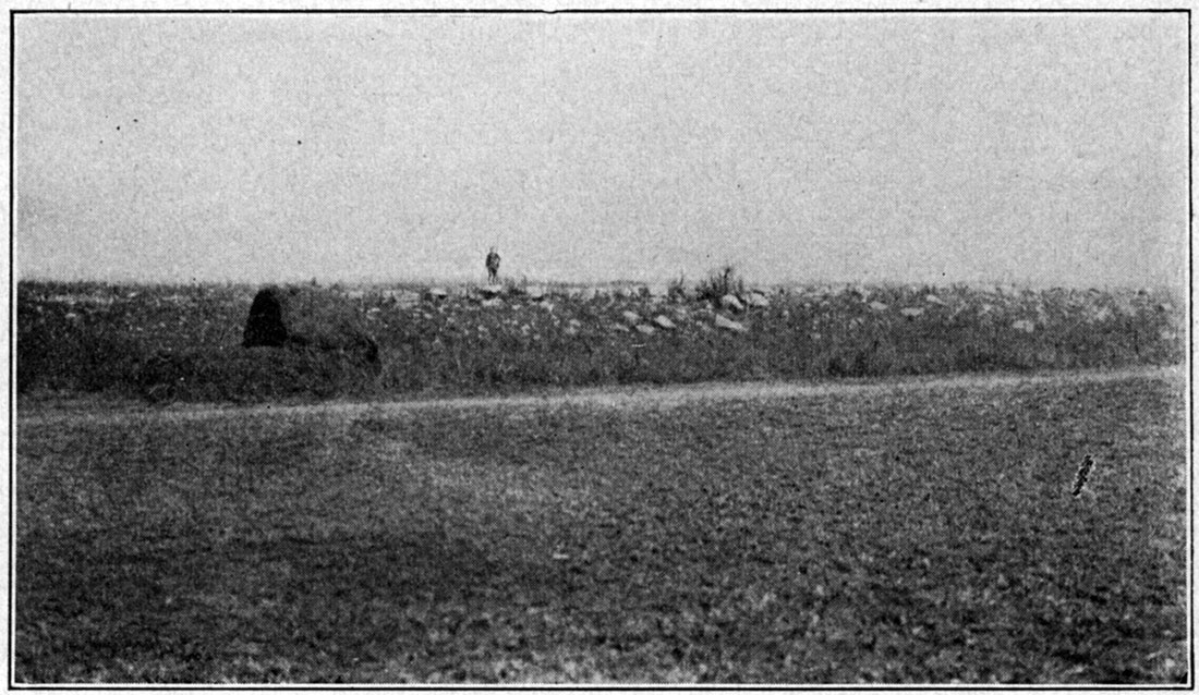
Plate XI—B, Outcrop of Towanda limestone, showing its thin-bedded, stratiform nature.
This limestone is well exposed at numerous localities besides the Towanda neighborhood. Some of the better of these exposures are near the S4 corner, sec. 21, T. 26, R. 4; in the south bank of the creek, one-quarter mile south of N4 corner, sec. 33, T. 26, R. 4; in the SE, sec. 14, T. 25, R. 5; sec. 17, T. 25, R. 5; and sec. 32, T. 24, R. 6. At a few places a small, indeterminable gastropod is represented by numerous individuals, covering the surface of Towanda limestone slabs.
Upper shale bed. The upper portion of the Doyle shale is truly shale, and in the Eldorado field varies from 50 to 60 feet in thickness. It is variegated in color, with greenish to yellowish-gray predominating, but containing also, in its lower part, several maroon and dark-gray bands. The upper few feet are transitional in nature, becoming more and more calcareous, until they merge into the Winfield limestone. These upper few feet of calcareous shale contain in places a large number of fossil remains, particularly of the brachiopod Derbya multistriata, which, where conditions are favorable, weather out in large quantities and may be picked up easily by the handful. This is particularly true in the railroad cut at the north side of sec. 19, T. 25 S., R. 5 E.
The best exposure in the Eldorado district of the upper shale bed of the Doyle is below the Winfield escarpment in the S2, sec. 28, T. 26 S., R. 4 E. The upper part of the shale is exposed at several places beneath the Winfield at the S2 corner, sec. 24, T. 25, R. 4; in the road east of W4, corner, sec. 18, T. 25, R. 6; and along the creek in the NW, sec. 5, T. 25, R. 5.
The transitional beds at the top of the Doyle yielded the following fauna, as identified by Doctor Girty:
| Echinocrinus edgarensis Spirorbis sp. Leioclema ? sp. Septopora gracilis ? Rhombopora lepidodendroides Derbya multistriata Productus calhounianus Composita subtilita Myalina wyomingensis ? |
This list, which includes all the species found in the immediately overlying Winfield limestone, should, perhaps, because of its intimate relation to the Winfield, be considered a Winfield fauna, or at least a phase of it.
Winfield Limestone
[Note: Named after Winfield, Cowley County, Kansas. Prosser, p. 715, 1902.]
The Winfield is the most prominent ledge-forming bed in the Eldorado field, and its influence on the topography is to be seen in the mild escarpments which border the field, beginning on the northeast side and swinging around to the north, west and southwest. The position of the Winfield escarpment may be noted by the position of its outcrop as shown in plate 1. The escarpment-forming quality of the Winfield lies in its relatively greater resistance to erosion as compared with the immediately underlying and overlying shales.
Plate XII—Two outcrops of Winfield limestone, showing its concretion-bearing nature.
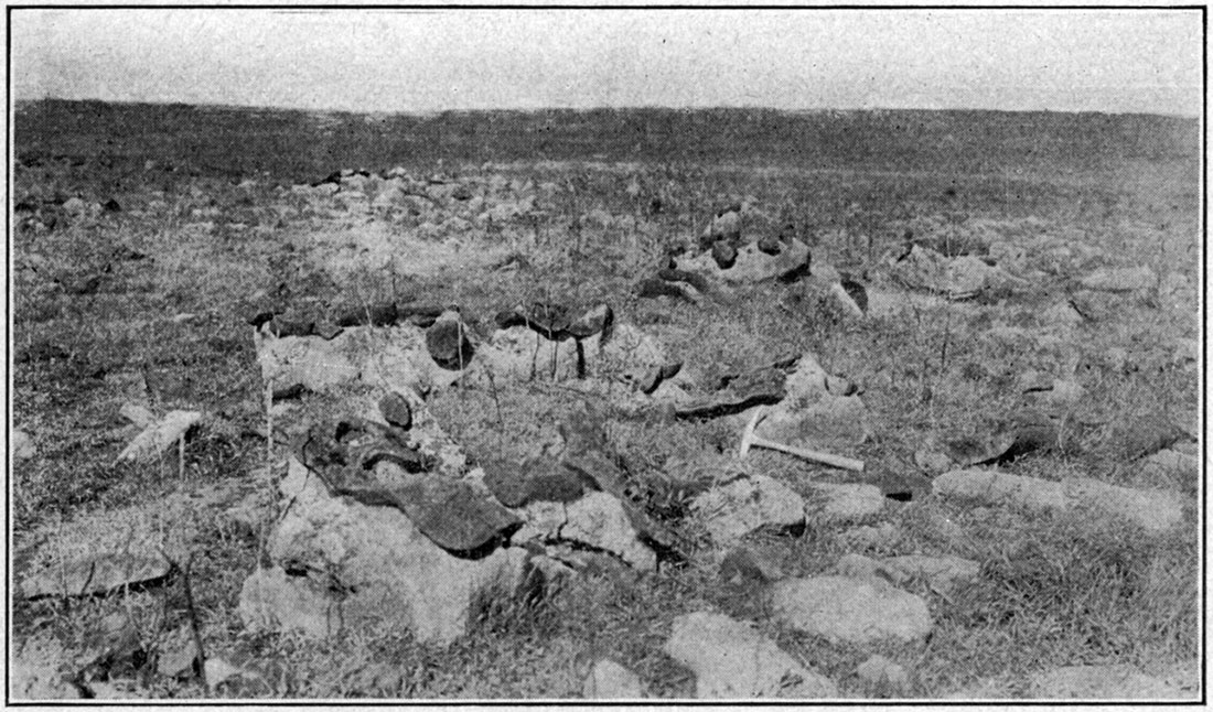
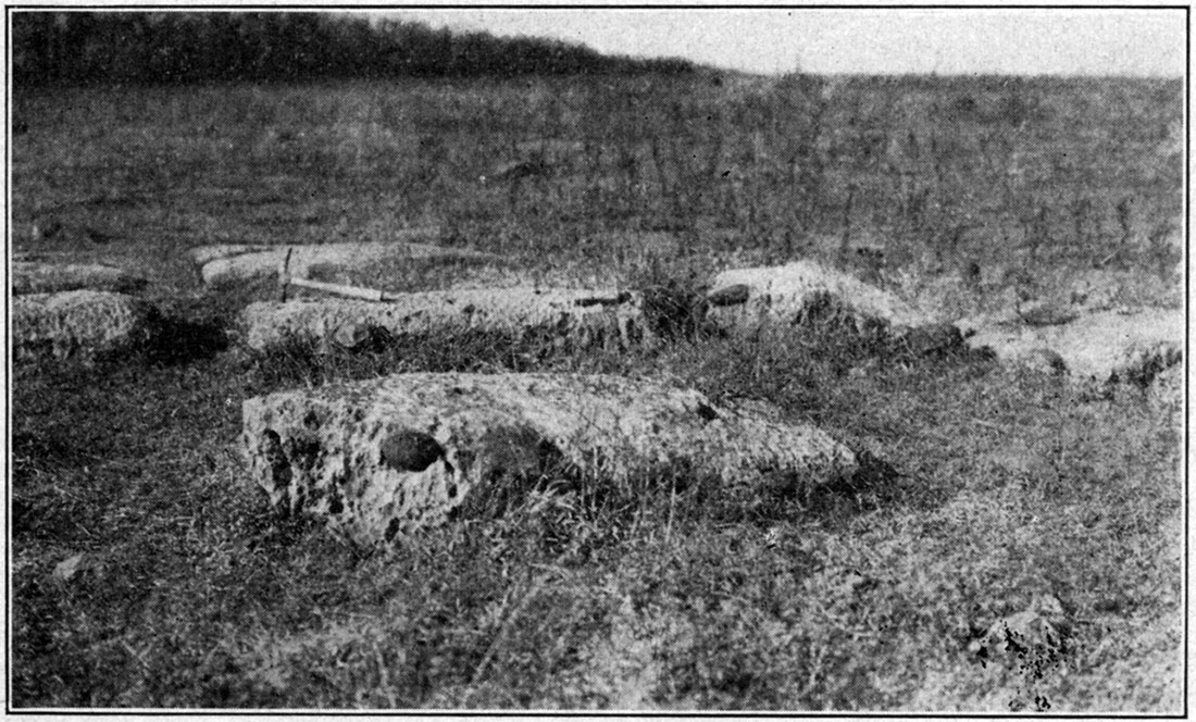
Plate XIII—A, Outcrop of Winfield limestone, forming a double bench.
The Winfield member in the Eldorado district is represented by a single heavy-bedded limestone from 8 to 9 1/2 feet in thickness, in contrast to a threefold limestone and shale division in the Cottonwood Falls quadrangle (Prosser and Beede, 1904) and some other districts. Most of this thickness is formed by two beds, which in many exposures form a double bench. (See plate XIII, A.) The limestone is light gray to whitish in color and it contains abundant fossil remains, mostly fragmentary. On the weathered surface these fragmentary fossils stand out in relief and give the rocks a rough or highly etched appearance-its most characteristic feature. The presence of irregularly rounded reddish-brown concretions in several places is a local feature. (See plate XII.) In most places these concretions are exceedingly abundant, and in some places, because of their greater resistance, they form what may be termed a residual mantle on the slope beneath the Winfield. The concretions appear to be masses of fragmentary fossil remains embedded in a ferruginous and calcareous matrix. Reddish-brown is their weathered color, while the fresh surface is a mottled dark gray. The concretionary character is developed principally in the following three localities: Secs. 25 and 36, T. 24 S., R. 5 E.; secs. 30 and 31, T. 24 S., R. 6 E.; N2, sec. 13, T. 25 S., R. 5 E.; and the west side of sec. 24, T. 25 S., R. 4 E., and for a mile or so to the southwest.
The fauna of the Winfield in the Eldorado district includes the following forms, identified by Doctor Girty:
| Septopora gracilis ? Derbya multistriata Productus calhounianus ? Myalina wyomingensis ? |
Marion Formation
[Note: Named after Marion county, Kansas. Prosser, p. 786, 1895.]General Statement. In the Eldorado field the Marion formation is represented by 65 to 80 feet of shale and limestone, which contains three mappable members: (1) A lower shale and soft, nonresistant limestone, aggregating 45 to 50 feet in thickness, tentatively correlated with the Enterprise shale member; (2) a middle ledge-forming limestone, 3 feet thick, which is believed to represent the Herington limestone member; and (3) an upper shale, 15 feet thick, which is tentatively correlated with the Pearl shale member. The correlation of these beds with the recognized members of the Marion in its type locality 30 miles to the north is tentative, and hence the uncertainty is indicated throughout the report by the use of question marks.
The type localities of these three members of the Marion formation are in Dickinson and Marion counties, where the section of the Marion formation has been differentiated as follows:
| Subdivisions of the Marion formation | Thickness | |
|---|---|---|
| ft. | in. | |
| Pearl shale, thickness estimated | 70 | |
| Herington limestone | 9 | |
| Enterprise shale | 35 | 8 |
| Luta limestone | 30 | |
[Note: Beede, 1908. It appears from recent investigations by members of the State Geological Survey of Kansas in Dickinson, Marion and Harvey counties that the subdivision Abilene conglomerate, which has been included at the top of the Marion formation, is not a Permian deposit. The upper limit of the Marion is marked by thin limestone beds at the top of the Pearl shale division.]
The Luta limestone member, if present, is not exposed in the Eldorado section, hence the lower shale and shaly limestone division as recognized in the Eldorado district is tentatively correlated with the Enterprise shale. The Herington limestone member, which follows, is described at the type locality as a buff, massive, very fossiliferous bed, with a thickness of 9 feet, which is quite in contrast with the bed in the Eldorado field that is provisionally correlated with it. The principal reason for the correlation is the similarity in stratigraphic position with respect to the Winfield limestone. In the Eldorado section the first ledge-making limestone above the Winfield is separated from the latter by a considerable thickness of shale, and soft, nonresistant limestone.
Enterprise (?) Shale
[Note: Named after Enterprise, Dickinson county, Kansas. Beede, p. 253, 1908.]
The lower 45 to 50 feet of the Marion is generally represented by a smooth, grass-covered surface, on which in places there is scattered a large amount of residual chert. Since chert is so invariably, and apparently necessarily, associated with limy material, the supposition which is borne out by a few small, unsatisfactory and scattered exposures-is that this residual chert indicates that some of the Enterprise shale member in the Eldorado field consists of limestone, which, because of the absence of exposures, is probably soft and nonresistant. At a few places gray calcareous shale was also observed. As already stated, these beds are only tentatively correlated with the Enterprise shale member of the Marion as developed to the north.
Herington (?) Limestone
[Note: Named after Herington, Dickinson county, Kansas: Beede, p. 253, 1908.]
The middle division of the Marion formation in the Eldorado field is limestone, dull bluish-gray in color, with a thickness which varies little from three feet. Its resistance to erosion is generally sufficient to form ledges, and in a few places it even produces low escarpments. On the whole, however, its outcrop is inconspicuous. Its general character is well illustrated by the following section and the photograph of this section (plate XIII, B):
| Section of the Herington (?) limestone member exposed in small quarry, near center N2, sec. 34, T. 26, R. 4. | Thickness | |
|---|---|---|
| ft. | in. | |
| Limestone, light yellowish-gray, single bed; contains numerous small calcite geodes and small cauliflower-like chalcedony concretions; upper surface partly incrusted with gray chert | 0 | 11 |
| Limestone, light gray, sbaly or limy shale | 2 | |
| Limestone, light gray, thin bedded | 2 | 0 |
| Total | 3 | 1 |
Plate XIII—B, Exposure of Herington (?) limestone.
At one place only, in the SE, sec. 12, T. 25, R. 4, were any fossil remains observed in this limestone, and these consisted of a single species identified by Doctor Girty as Pseudomonotis hawni.
Pearl (?) Shale
[Note: Named after Pearl, Dickinson county, Kansas: Beede, p. 255, 1908.]
Probably not more than 15 to 30 feet of the upper portion of the Marion formation above its Herington (?) limestone member is present in the Eldorado field, and no exposure of it was observed. Residual chert is present on the surface in some places, but other than the nonresistance of the strata to erosion there is no indication as to the material of which they are composed. Probably they are shale and soft limestone. If the correlation of the underlying limestone with the Herington limestone member is correct the correlation of the upper part of the Marion in the Eldorado field with the Pearl shale member is beyond question.
Quaternary Deposits
Covering the broad valleys of Walnut and Whitewater rivers and their larger tributaries are accumulations of muds, gravels and sands of comparatively recent geological age, deposited during the period since the rivers cut to grade and while they have been broadening their valleys by lateral planation. The materials were derived from the higher valley reaches and were brought to their present location principally during flood periods.
The valley alluvium in the Eldorado region contains but little common quartz sand because of the meagerness of siliceous bed rocks in the drainage area from which sand could be derived. Stream action on the broken limestone fragments reduces the rock to pebbles and to sandlike particles, but these small grains are relatively unstable because of weathering and their relative lack of resistance to solution in the ground waters. Hence calcareous sands, as such, do not form large quantities of the valley alluvium. The coarser materials—that is, the gravels and rubble—are in large part limestone fragments. The clays of the alluvium consist principally of the transported clays and shales of the shale formations, and in part of the weathering products of the limestones.
Prev Page--History || Next Page--Structure
Kansas Geological Survey, Geology
Placed on web July 28, 2017; originally published 1921.
Comments to webadmin@kgs.ku.edu
The URL for this page is http://www.kgs.ku.edu/Publications/Bulletins/7/05_strat.html