![]()
Prev Page--Mesozoic || Next Page--Igneous, Bibliography
Paleozoic Rocks
Sedimentary, igneous, and metamorphic rocks of all sorts formed during the great span of geologic time called the Paleozoic era have no classificatory designation that is generally used to refer to them collectively. Somewhat loosely, therefore, we term them Paleozoic rocks. The outcropping rocks throughout most of eastern and central Kansas are all sedimentary strata of Late Paleozoic age. They include shale, sandstone, limestone, and conglomerate having widely varied characteristics, as well as coal beds, dolomite, and some, other rock types. Paleozoic rocks underlie all of western Kansas. Locally exposed igneous rocks in Woodson County may be Paleozoic but they are probably much younger. The total thickness of exposed Paleozoic rocks in Kansas, derived by compiling average measurements of recognized subdivisions, may be given as approximately 6,000 feet.
Permian System
Rocks of Permian age crop out in eastern Kansas in a belt extending from Washington, Marshall, Nemaha, and Brown counties, on the northern boundary, to Meade, Clark, Comanche, Barber, Harper, Sumner, and Cowley counties, on the Kansas-Oklahoma line. The total outcrop thickness is about 3,000 feet.
Guadalupian Series
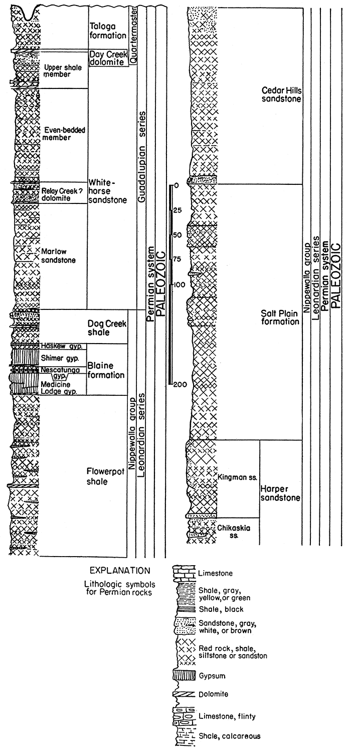
This division of the Permian system, which is defined from fossiliferous marine rocks in western Texas and southeastern New Mexico, crops out in southern Kansas. In this region, it comprises unfossiliferous deposits that seem to have been laid partly on land by sluggish streams and action of winds and partly in shallow basins occupied by strongly saline waters. Bedding is mostly irregular. Reddish color, which signifies abundance of ferric oxide, prevails. Thickness of outcropping rocks belonging to this series in Kansas is about 290 feet.
Quartermaster group
Permian beds above the Day Creek dolomite have been classified as belonging in the Quartermaster group. They seem to be equivalent to the lower part of the Quartermaster formation of western Oklahoma and the panhandle region of Texas. The maximum outcrop thickness of these rocks in Kansas is about 45 feet.
Taloga formation--Redbeds of silty and sandy shale and sandstone, called "Big Basin" in some reports, belong to the Taloga formation. The lower 25 feet is chiefly silty shale. Outcrops are in western Clark and eastern Meade counties. The strata are seemingly equivalent, all or in part, to the Quartermaster formation in Oklahoma. Thickness, maximum about 45 feet; average 20 feet.
Beds below the Taloga formation and above the Dog Creek shale are not assigned to a group.
Day Creek dolomite--Fine-grained dense dolomite cropping out in western Clark county. It is seemingly absent between the northern part of T. 33 S., R. 24 W. and a point in Oklahoma near the center of T. 25 N., R. 25 W. (Indian meridian). Thickness in Kansas is about 2 feet.
Whitehorse sandstone--Redbeds of sandstone, siltstone, and shale, and a minor amount of dolomite. Cross bedding is common and the formation is characterized by "sand balls," which are water-worn small "sand crystals" consisting of sand pseudomorphs after calcite, and by crystals of barite, anhydrite, calcite, and gypsum. The outcrops are in southeastern Meade, Clark, and southwestern Kiowa counties. Thickness is about 270 feet.
Upper shale member--Redbeds of shale and a minor amount of sandstone, with a zone of dolomitic beds in the basal part and a zone of gray-green sandy shale in the upper part, mostly brick-red or maroon. Thickness is about 38 feet.
Even-bedded member--Sandstone and shaly siltstone, mostly even-bedded but locally cross-bedded in the upper part; containing "sand balls" and "sand crystals"; maroon. Thickness is about 100 feet.
Relay Creek? dolomite and sandstone member--Two beds of dolomite separated by red and white sandstone of variable texture. The dolomite beds range in thickness from a few inches to about 1 foot. Locally the dolomite beds are altered to anhydrite or gypsum. Individual layers in the sandstone are identified with difficulty; locally the rock is cross-bedded. Thickness is about 22 feet.
Marlow sandstone member--Redbeds of sandstone, fine-grained, locally shaly or silty, cross-bedded. "Sand balls" locally prominent. Thickness about 110 feet.
Conformity
Leonardian Series
This major division of the Permian, named from strata in the Glass Mountains region of western Texas, is judged to be represented in Kansas by about 1,900 feet of rocks that are chiefly unfossiliferous clastics (sandstone, shale) and evaporites (anhydrite, gypsum, salt). Red shale, siltstone, and sandstone predominate in the upper part. Gray shale is the most common rock type in the lower part, although red and other bright colors are present.
Nippewalla group
The upper part of strata assigned to the Leonardian series, named from Nippewalla river in Kingman county, is most widely exposed in south-central Kansas west of Arkansas river. This group consists mostly of redbeds that form a plain. In Barber County and adjacent areas the topography of the Nippewalla outcrop area locally has considerable relief and is "badland" in type. Gypsum beds make prominent escarpments. The total thickness of the group is approximately 930 feet.
Dog Creek shale--Maroon shale, sandstone, thin layers of dolomite, dolomitic sandstone, and gypsum. The top generally is marked by about 3 feet of maroon shale, but locally a gypsum bed about 1 foot thick and having red stripes occurs at the top. The most persistent part is a bed of white and red sandstone, about 6 feet thick, that locally is capped by dolomitic sandstone, which occurs next below the upper maroon shale portion. The outcrops are in southern Kiowa, eastern Comanche, and western Barber counties. In Kiowa county the formation is overlapped by Cretaceous sandstone (Cheyenne). The reported thickness ranges from 14 to 53 feet; average about 35 feet.
Blaine formation--Gypsum beds separated by dolomite and red shale. The formation is divided into four members. Outcrops are in Clark, Comanche, Barber, and Pratt counties. The thickness is about 50 feet.
Haskew gypsum member--One foot or less of gypsum underlain by about 5 feet of red shale. The gypsum bed has been removed by solution at many places. The thickness of the gypsum and underlying shale beds is about 6 feet.
Shimer gypsum member--A thick bed of gypsum overlying a bed of dolomite that ranges in thickness from about 6 inches to 1% feet. Excessive solution and erosion of the gypsum bed have greatly reduced its thickness in many places. Measured sections believed to show the original thickness range from 14 to 24 feet; average 19 feet.
Nescatunga gypsum member--A bed of gypsum with overlying and underlying red shale. The gypsum bed varies in thickness within short distances and is known to range from about 2 to 8 feet. Locally as much as 8 feet of red shale separates the gypsum from the next higher and lower gypsum beds. Average 5 feet.
Medicine Lodge gypsum--The thickest bed of gypsum in Kansas. Ordinarily there is a bed of dolomite at the base which ranges from 6 inches to 1 foot in thickness. Exposures are in Barber, Clark, and Comanche counties. This gypsum bed forms a conspicuous rim rock at the top of steep slopes of the Flowerpot shale. The maximum thickness is 30 feet or more; average 20 feet.
Flowerpot shale--Shale, red, soft, gypsiferous. A thin lenticular bed of dolomite has been observed in the middle part, and the formation is cut by intersecting veins of satin spar gypsum. Outcrops are in Barber, southeastern Kiowa, and Comanche counties. Commonly stands in steep slopes, eroded into innumerable gullies, and strewn with clear, white, pink, and red satin spar and clear crystals of selenite. Measured thicknesses range from 170 to 190 feet, average 180 feet.
Cedar Hills sandstone--Sandstone and siltstone, chiefly red, containing beds of white sandstone in the upper and lower parts; the upper one contains "snow balls" of white gypsum. Shaly siltstone separates the more resistant and more massive sandstones. The upper part below the "snow ball"bearing sandstone commonly is eroded into a badland plateau. The more massive sandstones are generally weathered into rounded hills and the shaly portions are weathered into canyon-dissected slopes. Outcrops are in Barber and Harper counties. Thickness is about 180 feet.
Salt Plain formation--Chiefly red, flaky, silty shale and some siltstone and sandstone. There are two prominent sandstone beds, the upper, about 25 feet thick, occurring about 42 feet below the top of the formation and the lower (Crisfield), about 29 feet thick, occurring about 115 feet below the top of the formation. The sandstones are partly cross-bedded. Outcrops are in southeastern Barber, Harper, and southern Kingman counties where the formation has weathered into a nearly featureless plain. In Kingman County the formation is overlapped by Cenozoic deposits. The thickness is reported by George H. Norton to be 265 feet.
Harper sandstone--Chiefly red, divided into two members. The outcrops are in Harper, Kingman, Reno, and Rice counties. Northward the formation is overlapped by Cenozoic rocks. Thickness is about 220 feet.
Kingman sandstone member--Red sandstone and a few beds of red shale and white sandstone. A prominent bed of white sandstone, 3 feet thick, occurs at the base. Thickness is about 80 feet.
Chikaskia member--Sandstone and shale, mostly red but some gray; fissile, fine-grained, ripple-marked and locally cross-bedded sandstone in the lower part. Some white sandstone and dolomite lenses and concretions occur in the upper part. Along the outcrop in Kansas the formation thins northward, and the thickness ranges from about 100 to 160 feet; average 140 feet.
Figure 4--Generalized section of upper Permian rocks in Kansas.
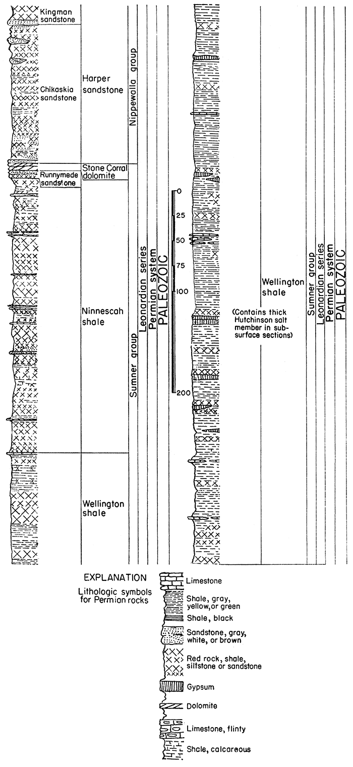
Sumner group
This division comprises about 1,000 feet of strata at the outcrop, chiefly shale. Thick beds of salt occur in the subsurface. Gray shale predominates but there are also beds of red and green shale and deposits of dolomite, limestone; gypsum, and anhydrite.
Stone Corral dolomite--Dolomite, anhydrite, and gypsum. The anhydrite and gypsum portions are lost in exposed sections and the remaining dolomite ledge is cellular or contains numerous calcite-filled vugs. The color is chiefly gray but locally there are red and pink streaks. At some exposures the formation is chiefly red shale, bounded above and below by thin dolomite beds. Ripple marks on dolomite slabs are more or less characteristic. The outcrop belt is interrupted in eastern Rice, western McPherson, and other counties to the south by eastward overlap of Cenozoic deposits. This is one of the most readily recognized "key beds" in the Kansas redbed section. It is reported to produce well-marked reflections in seismograph surveys. Maximum measured thickness at the outcrop is about 6 feet.
Ninnescah shale--Predominantly shale, mostly red, but containing some gray shale, impure limestone, and calcareous sandstone. The Runnymede sandstone, 7 to 8 feet thick, forms the upper part of the formation. G. H. Norton has found that seven other distinctive beds of sandy or calcareous material can be traced for long distances. Estheria shells are rather common. Some of the beds show ripple marks. Rosette-shaped calcareous concretions occur in the middle part. Weathering and erosion in this part have produced the "Red Jaw" country in Reno county. The formation thins northward. In the subsurface near the Nebraska line it is about 50 feet thick. The maximum outcrop thickness is about 450 feet; average thickness at outcrop, about 300 feet.
Wellington formation--Chiefly shale, with a few hundred feet of salt in the middle part in the subsurface. Outcrops contain several more or less lenticular beds of gypsum and impure limestone. The Milan limestone member, consisting of 1 foot of greenish-gray shaly limestone that on the outcrop is characterized by bright-green copper carbonate, occurs at the top and thus marks the top of the Wellington formation in a comparatively large area. Elsewhere change in color from gray to red may be regarded as the upper boundary, which may be at different horizons in different places. The upper 300 feet of the Wellington is largely gray shale with thin interbedded deposits of calcareous material. The Hutchinson salt member occurs in the middle part but is not exposed. The fossil insect-bearing Carlton limestone member occurs a short distance below the Hutchinson salt. Bright red and green shale is conspicuous in the lower part, which contains more or less discontinuous beds of impure limestone and gypsum. A bed of impure dolomitic limestone, not definitely known to be of widespread occurrence, has been named the Hollenberg limestone. In general, outcrops of the Wellington formation are poor and discontinuous. The total thickness of the formation is about 700 feet.
Conformity
Figure 5--Generalized section of middle Permian rocks in Kansas.
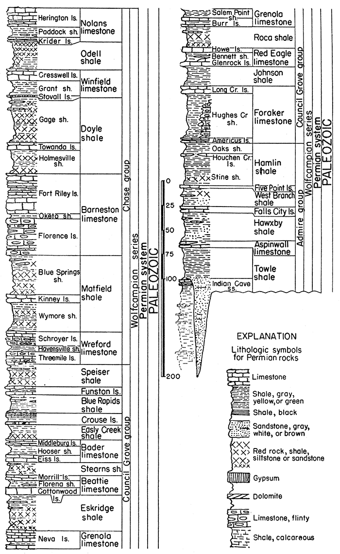
Wolfcampian Series
This division, formerly called the Big Blue series, contains the older Permian rocks of Kansas. Shales and limestones predominate, subdivisions being remarkably persistent. The thicker shales are bright colored and the limestones are mostly light gray bleached-bone color. The outcrop thickness in Kansas is about 835 feet.
Chase group
The topmost group of Wolfcampian beds is made up of about 370 feet of prominent escarpment-making limestones and shales. The shale units are characterized by bright reds and greens. Flint-bearing limestone forms an important part of this division, which largely comprises the rocks in which the Flint Hills are developed from Washington, Marshall, and Nemaha counties on the northern boundary of Kansas to Cowley County on the Kansas-Oklahoma line.
Herington limestone member--Limestone and dolomite, yellowish-tan, soft and dense, more dolomitic in southern Kansas than in the northern and central parts of the state. Outcrops are characterized by siliceous and calcareous geodes and concretions and cauliflower-like masses of drusy flint weathered from the matrix. Fossil mollusks are locally abundant. Thickness ranges from about 7 to 10 feet in the northern part and about 30 feet in the southern part of Kansas; average 20 feet.
Nolans limestone--This formation consists of upper and lower limestone members separated by shale. The thickness ranges from about 22 to 40 feet; average 34 feet.
Paddock shale member--Shale, gray, in northern Kansas containing stringers and vein fillings of calcite; in southern Kansas buff, calcareous, and containing limestone in the lower part. Fossil pelecypods are locally abundant in northern outcrops. The thickness is about 9 feet in Cowley County and ranges between 11 and 13 feet farther north; average 11 feet.
Krider limestone member--Commonly two beds of limestone separated by a bed of shale, each about 1 foot thick. In southern Kansas the separating shale is somewhat thicker. In most exposures the color is yellowish-brown. Characteristic thickness is about 3 feet.
Odell shale--Shale, gray, yellow, and red chiefly, but with some blue shale in the southern part of Kansas. Along most of the outcrop, red is predominant in the upper and middle parts; gray or yellow is characteristic of the lower part. Thicknesses range from about 20 to 40 feet; average 30 feet.
Winfield limestone--A thick upper limestone underlain by about 10 feet of fossiliferous gray shale, which is underlain in turn by a thin bed of flinty limestone. The members are not definitely identified in southern Kansas. The combined thickness is about 28 feet.
Cresswell limestone member--This member consists of limestone and locally shale in the upper and middle part, and of massive fossiliferous limestone in the lower part. The upper part, which has been called "Luta limestone," is thinner bedded and more shaly. The shaly middle part commonly contains calcareous concretions and geodes. Echinoid spines and other fossils are plentiful in the lower massive limestone. Throughout a considerable distance the lower massive ledge is almost constantly 3 feet thick. Total thickness of the member is commonly about 17 feet.
Grant shale member--Shale, gray, calcareous and fossiliferous. This is a distinct unit except in southern Kansas, where it probably has been included in the lower part of the Cresswell limestone. Thickness is about 10 feet.
Stovall limestone member--Limestone, gray, dense, with an abundance of steel-gray flint. Fossils are rare. The thickness is commonly about 1 foot.
Doyle shale--Two shale members and a separating limestone member. The thickness is about 80 feet.
Gage shale member--This part of the Doyle consists mostly of clayey shale, but calcareous shale and a minor amount of limestone occur in the upper part. The lower and middle parts are chiefly varicolored noncalcareous shale consisting of red, green, purple, and chocolate-colored zones interbedded with gray and yellow layers. Locally, a limestone lentil occurs not far from the top and is separated from the overlying Winfield limestone by the more calcareous fossiliferous part of the member. The characteristic thickness is approximately 48 feet.
Towanda limestone member--Limestone, light bluish-gray to yellow, slabby and platy. Fossils are generally absent or rare. About 15 feet has been measured in Geary county but the common thickness ranges from about 5 to 9 feet; average 7 feet.
Holmesville shale member--Shale, gray, yellow, red, green, unfossiliferous. The thickness ranges from about 20 to 30 feet; average 25 feet.
Barneston limestone--This formation comprises two limestone members separated by a thin shale member. The upper limestone makes an extensive dip slope and crops out as a steep escarpment that extends from north to south across Kansas. The west portion of the Flint Hills is capped chiefly by the Barneston limestone. The thickness of the formation ranges from about 80 to 90 feet; average 84 feet.
Fort Riley limestone member--Limestone, light gray and tan, massive and thin-bedded, and a minor amount of gray shale. This limestone is naturally divided into four parts, the thicknesses of which vary from place to place. In the basal part there are thin, more or less shaly beds that are overlain by a massive "rim rock," which is a conspicuous outcrop maker. Thin shaly beds and locally clay shale deposits occur in the middle part. The upper strata are rather massive but less so than the "rim rock." The youngest fusulines known in Kansas occur in the Fort Riley limestone. The thickness ranges from about 30 to 45 feet; average 40 feet.
Oketo shale member--Shale, gray, calcareous. Generally absent in southern Kansas and locally absent elsewhere. The thickness, according to measured sections, ranges from a featheredge to 17 feet, but where present this shale parting between flinty limestone below and non-flinty limestone above is generally less than 6 feet; average 5 feet.
Florence limestone member--Limestone, an abundance of flint, and a minor amount of shale. The limestone is commonly lighter in color than the included nodules and layers of steel-gray flint. Shale partings are rather common locally. Fossils, including fusulines, bryozoans, corals, pelecypods, and brachiopods, are somewhat sparse. In most places along the outcrop the thickness is between 35 and 45 feet; average 40 feet.
Matfield shale--Two units of varicolored shale separated by a limestone member. The thickness ranges from about 60 to 90 feet; average 78 feet.
Blue Springs shale member--Shale, chiefly red and gray, and a relatively minor amount of limestone except in southern Kansas where several limestone beds occur in the upper part of the member. Farther north the member is less calcareous and limestone is absent. Fossils occur in thin limestones and in gray shale beds in the southern part of the outcrop area. The thickness is about 40 feet.
Kinney limestone member--Limestone and shale. Locally there is a single bed of gray, massive or thin-bedded limestone but elsewhere two or more limestone beds are separated by shale. The limestone is sparsely fossiliferous and the associated shale is commonly abundantly fossiliferous. The thickness ranges from a few feet to about 20 feet; average 8 feet.
Wymore shale member--Shale, chiefly gray and yellow but including red, green, and purple bands. Locally most of the unit is composed of bright-colored clay shale. Limestone beds and fossiliferous shale beds are included in the lower part in the southern part of the state. The thickness is about 30 feet.
Wreford limestone--Two limestones and a shale member. The limestone members are characterized by an abundance of flint in some of the beds. The thickness ranges between about 30 and 40 feet; average 35 feet.
Schroyer limestone member--Limestone, light gray to nearly white, mostly flint-bearing, but commonly containing a non-flinty bed (about 3 feet thick) in the upper part. The thickness is about 18 feet.
Havensville shale member--Shale, gray and calcareous, and thin limestone beds. This unit cannot be easily identified in parts of southern Kansas where the Wreford limestone comprises a continuous limestone section. Thickness in northern Kansas is about 10 feet; average 7 feet.
Threemile limestone member--Limestone, light gray to nearly white, flinty in part, but containing more massive and more resistant non-flinty beds. The thickness is about 10 feet.
Council Grove group
This division of the Permian rocks comprises about 320 feet of limestone and shale. Throughout most of the outcrop area little or no flint occurs in these rocks. In general, they include less massive and thinner limestone units than occur in the overlying group. The group includes strata that, according to older classification, were divided (in descending order) into "Garrison shale," Cottonwood limestone, Eskridge shale, Neva limestone, "Elmdale shale," and Americus limestone.
Speiser shale--Shale and limestone, formerly classed in the upper Garrison shale, make up the Speiser shale. The upper part consists of gray fossiliferous shale underlain by a remarkably persistent limestone bed, which is commonly less than 1 foot thick and occurs about 3 feet below the Threemile limestone. The remainder of the formation consists of beds of varicolored shale, red shale being predominant. The thickness of the formation is about 18 feet in northern Kansas and about 35 feet in the southern part of the state where a lenticular bed of sandstone occurs in the middle part; average 25 feet.
Funston limestone--Light-gray to bluish-gray limestone and gray to ~ yellow shale are contained in the Funston limestone. The limestone occurs in rather massive, sparsely fossiliferous layers, and commonly the beds are separated by shale. In southern Kansas, bluish to nearly black shale occurs 5 in the lower part, and locally the lower limestone beds contain flint. The Funston limestone, Blue Rapids shale, and Crouse limestone were formerly classified as comprising the Bigelow formation. The thickness of the Funston ranges from about 5 to 11 feet; average 8 feet.
Blue Rapids shale--Shale, gray, containing local limestones. The thickness ranges from about 16 feet in southern Kansas to 25 feet in northern Kansas; average 20 feet.
Crouse limestone--Limestone and shale. Generally the formation comprises an upper and lower limestone separated by a few feet of shale. The upper part generally displays platy structure and weathers brown. In general the limestone beds are light gray and locally are flinty. The thickness ranges from about 10 to 13 feet; average 12 feet.
Easly Creek shale--Shale, red and gray, partly calcareous and containing local limestone beds. The upper part is light-colored and calcareous; the lower part is largely red shale. In Marshall county a bed of gypsum occurs near the base. The thickness is approximately 15 feet.
Bader limestone--Two limestones and a shale member. The thickness range is between approximately 18 and 25 feet; typically about 23 feet.
Middleburg limestone member--Limestone and shale, gray, sparsely fossiliferous. Generally there are two limestone beds separated by shale. Productids and Composita are somewhat plentiful in the lower limestone. The thickness ranges from about 4 feet near the Nebraska line to about 8 feet in southern Kansas; average 6 feet.
Hooser shale member--Shale and impure limestones. The shale is gray and fossiliferous, pelecypods predominating. The thickness along the outcrop line across the state is remarkably constant, about 10 feet.
Eiss limestone member--Limestone and shale. Two beds of limestone separated by shale are remarkably persistent across Kansas from Marshall and Nemaha counties to Cowley County. The upper limestone bed, 2 to 3 feet thick, is siliceous and locally contains some flint. The middle part (2 to 7 1/2 feet locally) consists of gray fossiliferous shale in which ramose bryozoans, chonetid brachiopods, and the brachiopod Meekella are plentiful. The lower limestone, 1 1/2 to 2 1/2 feet thick, is shaly, thin-bedded, and fossiliferous. The massive upper part of the Eiss limestone is a prominent bench maker in the eastern part of the Flint Hills. The characteristic thickness of the member is about 7 feet.
Stearns shale--This shale contains a minor amount of impure limestone. The color is mostly gray to olive but red shale occurs in the middle and lower parts. In southern Kansas the upper part contains fossil pelecypods and chonetid brachiopods. Thickness is 8 to 10 feet in southern Kansas and about 17 to 20 feet in the northern part of the state; average 14 feet.
Beattie limestone--Two limestones and a shale member. The thickness ranges from about 15 to 20 feet; average 18 feet.
Morrill limestone member--This unit consists of brown to gray impure cellular limestone that in the northern part of the outcrop area contains a thin shale parting. In southern Kansas the Morrill thickens, mainly as a result of algal accumulations in the upper part. The thickness ranges from about 2 to about 8 feet; average 5 feet.
Florena shale member--A highly fossiliferous gray shale, in southern Kansas containing thin limestone beds, is called Florena. It is the lowermost part of strata formerly classed under the name Garrison formation. The brachiopod Chonetes granulifer is abundant in this shale throughout its line of outcrop. In southern Kansas the variety of fossils is greater than in the north; the fauna contains numerous species of pelecypods and brachiopods and well-preserved specimens of a small trilobite are locally common. The thickness ranges from about 5 to 10 feet; average 7 feet.
Cottonwood limestone member--Limestone, massive, light buff, weathering nearly white, containing abundant slender fusulines in the upper part. Except in the southern part of the state, this is the most prominent limestone of the Council Grove group. In southern Kansas it is thin-bedded and shaly. Throughout most of its line of outcrop it is marked by a fringe of shrubs along the grass-covered Flint Hills slopes. Except for thinning toward the south, the thickness of the Cottonwood limestone is remarkably constant, amounting to about 6 feet.
Eskridge shale--Shale and a minor amount of impure limestone. The upper and middle parts are more calcareous and fossiliferous. Pelecypods and ostracodes are fairly abundant in thin limestone beds. The lower part is varicolored, consisting of red, chocolate-colored, and green clay shale interbedded with gray shale. The thickness is constantly about 37 feet.
Grenola limestone--As defined by the Kansas Geological Survey, this formation comprises two limestones and a shale member. The Nebraska Geological Survey includes in the Grenola a few feet of strata that are here classified as belonging in the upper part of the Roca shale. The thickness of the Grenola formation is about 38 feet.
Neva limestone member--This member consists mainly of light-gray massive to flaggy limestone, but includes some gray fossiliferous shale. In general, weathered outcrops of the limestone are brown and pitted, and they display marly facies and breccias of limestone fragments in a calcareous matrix. Fossils include fusulines, corals, and brachiopods. The shale partings are rather non-persistent. The common thickness is about 20 feet.
Salem Point shale member--Shale, gray, calcareous, without fossils or very sparingly fossiliferous. The thickness is about 8 feet.
Burr limestone member--Limestone, light gray, and shale, gray to olive and locally nearly black in the lower part. Ostracodes are plentiful in upper layers and mollusks are rather abundant in the limestone beds. The thickness ranges from about 8 to 14 feet; average 10 feet.
Roca shale--Shale and limestone; chiefly gray and olive clay shale but containing a large amount of red and locally some green shale. Subdivisions called Legion shale and Sallyards limestone at the top of the Roca are included in the Grenola formation by the Nebraska Geological Survey. The Sallyards limestone is a thin rather persistent bed but is not present in all exposures. The thickness of the Roca shale is about 20 feet.
Red Eagle limestone--Two limestones and a shale member. In southern Kansas, the Red Eagle limestone is a single ledge about 20 feet thick, but the two limestone. members that are differentiated in central and northern Kansas can be identified also in southern Kansas. The thickness across the state is rather constant, ranging from about 18 to 20 feet; average 19 feet.
Howe limestone member--Limestone, gray to brown, rather impure. Thickness in northern Kansas is commonly between 2 and 4 feet; average 3 feet.
Bennett shale member--Shale and locally some impure limestone. The shale is characteristically dark gray to black but locally the upper part is light gray or green. At some exposures, white fossil brachiopods are abundant in the black shale, forming coquinas composed largely of specimens of Crurithyris sp. The Bennett shale is absent in southern Kansas where the two bounding limestones are in contact. The thickness ranges from a featheredge to about 14 feet; average approximately 7 feet.
Glenrock limestone member--Limestone; gray and brown, impure in the northern part of the outcrop area, purer limestone in the southern part. In southern Kansas this member is believed to comprise the greater part of the conspicuous cliff-making Red Eagle limestone. In northern Kansas it is variable in lithology, changing from dense gray limestone to a mass of loosely cemented fusulines or to thin-bedded, slabby limestone. The thickness in the northern part of the state ranges from 1 to 2 feet but in southern Kansas it is about 17 feet; average 9 feet.
Johnson shale--Shale, gray, locally in northern Kansas containing thin beds of argillaceous limestone. Dark carbonaceous material occurs in the upper part of the shale in the north. The lower and middle parts are commonly somewhat sandy. The thickness ranges from about 16 feet in the northern part of the state to about 25 feet in the southern part; average 20 feet.
Foraker limestone--Two limestones and a shale member. The thickness is about 50 feet.
Long Creek limestone member--Alternating beds of yellow limestone and shale, or thin-bedded limestone, locally containing an abundance of fusulines in the northern part of the outcrop area. In southern Kansas light-gray limestone, more or less massive in the upper and lower parts, sparsely fossiliferous. Thickness is 5 to 8 feet; average 7 feet.
Hughes Creek shale member--In northern Kansas this part of the Foraker comprises light-gray to nearly black shale and thin limestone beds containing abundant fusulines and, in the lower part, a brachiopod fauna. In southern Kansas the member is a nearly continuous limestone section, massive in the lower part and containing much light-blue flint. Fusulines are plentiful in the flint and limestone. Thickness is about 40 feet.
Americus limestone member--Limestone, commonly in two beds separated by a thin shale, the upper bed locally containing flint nodules. The limestone is commonly bluish-gray and the shale is dark gray. Fusulines are abundant; pelecypods and brachiopods are plentiful. The thickness is about 4 feet throughout most of the line of outcrop but is somewhat less in the southern part of Kansas; average 3 feet.
Admire group
This division, formerly classed as Upper Pennsylvanian, comprises the lowermost 125 to 225 feet of the rocks in Kansas that now are considered assignable to the Permian system. The strata are chiefly clastic deposits, but they contain thin beds of limestone and some coal. Shale is the predominant rock type.
Hamlin shale--Two shales and a limestone member. Thickness about 50 feet.
Oaks shale member--Shale, mostly gray. Crystals of pink celestite occur as vein fillings in Brown County. The thickness ranges from about 10 feet in southern Kansas to perhaps as much as 20 feet in the northern part of the state; average 12 feet.
Houchen Creek limestone member--Limestone and shale, gray and porous, an algal deposit in part. This limestone zone seems to be lenticular, but is recognized north of Kansas river and has been identified in Chase and Elk counties. Measured thicknesses range from 1 foot in northern Kansas to 4 feet in the southern part of the state; average 2 feet.
Stine shale member--Shale, sandstone, and thin limestone beds. In northern Kansas the upper part is sandy shale, the middle part contains limestone beds, and the lower part contains some red shale below gray beds. In southern Kansas it is chiefly gray shale containing some limestone in the middle part. The thickness ranges from about 30 to 40 feet; average 36 feet.
Five Point limestone--Limestone, light to brownish-gray, slabby to nodular, containing fusulines, bryozoans, brachiopods, and algal remains. Thickness is 1 to 5 feet; average 3 feet.
West Branch shale--Shale, gray, green, and red, upper part sandy in southern Kansas. Limestone lenses occur in the West Branch shale in northern Kansas. Thickness ranges from about 10 feet in southern Kansas to about 30 feet in the northern part of the state; average 20 feet.
Falls City limestone--Two thin limestone beds separated by about 8 feet of fossiliferous shale in northern Kansas; in central and southern Kansas a single limestone bed, or locally absent. The fossils include algal remains, fusulines, bryozoans, mollusks, and brachiopods. Locally pelecypods are abundant in the upper part. This limestone is classed as the upper member of the Chicago Mound formation by the Nebraska Geological Survey. The thickness ranges from about 2 1/2 to 10 feet; average 7 feet.
Hawxby shale--Shale deposits containing thin, lenticular, mollusk-bearing limestones and, more locally, coal beds; sandy in the middle and lower parts. Thickness ranges from about 12 feet in northern Kansas to about 40 feet in the southern part of the state; average 30 feet.
Aspinwall limestone--Limestone or two thin limestones separated by shale. Unfossiliferous limestone, 1 to 3 feet thick, in the northern part of the outcrop area, but in southern Kansas, where it comprises two limestone beds (3 feet) and as much as 5 feet of shale, the lower limestone bears thick-shelled pelecypods and the upper limestone contains pelecypods and brachiopods. It is classed as the lower member of the Chicago Mound formation by the Nebraska Geological Survey. Average thickness 5 feet.
Towle shale--Clayey and sandy shale, siltstone, and sandstone. The upper part is chiefly gray slightly sandy clay shale, but in northern Kansas it contains some red and green clay. The Indian Cave sandstone occurs in the lower part and is only locally present, filling channels as deep as 120 feet. The thickness of the Towle formation ranges from about 15 to 135 feet; average 30 feet.
Indian Cave sandstone member--Sandstone, siltstone, and locally conglomerate in the lower part. Local channel fillings that grade upward into the basal part of the unnamed upper member of the Towle shale. Thickness ranges from a featheredge to about 120 feet.
This seemingly important, although obscure, unconformity is marked mainly by large channel sand fillings. It is traceable from Nebraska into Oklahoma. Erosion channels below the Indian Cave sandstone bring deposits classified as lowermost Wolfcampian into contact with rocks ranging downward from the Brownville limestone, or possibly slightly younger beds, to the Dover formation or lower. This evidence of widespread erosion, accompanied by rather noteworthy change in the lithologic characters of limestones, and paleontologic change, which is accentuated by the disappearance of old species and the appearance of some new genera and species, warrant the placement of the Wolfcampian-Virgilian boundary at this position.
Unconformity
Figure 6--Generalized section of lower Permian rocks in Kansas.
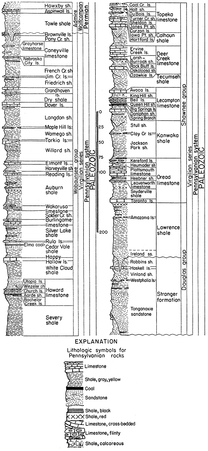
Pennsylvanian System
This division of Late Paleozoic rocks is widely represented throughout the world, being distinguished by importance of its coal deposits and by characters of its large assemblage of marine invertebrates and varied land plants. It is one of the most important among outcropping strata of Kansas, both on account of the economic value of its contained materials and the scientific value of its rock succession as a standard of reference in studies of equivalent-aged deposits in other parts of the continent. The Pennsylvanian rocks comprise the upper part of a large division that has long been known as the Carboniferous system. The term Carboniferous is almost universally used by geologists outside of North America and has been employed by the State Geological Survey of Kansas in designating outcrops shown on the large geological map of the State (1937) and described in numerous reports. Pennsylvanian rocks have been classified in these publications as a subsystem. Here, we recognize the validity of considerations that have led a great majority of American geologists to treat the Pennsylvanian as an independent geologic system. The aggregate thickness of exposed formations belonging to this system in Kansas is about 3,100 feet. Outcrops occur throughout the eastern one fourth of the state.
Virgilian Series
The Virgilian series comprises the youngest Pennsylvanian rocks of the midcontinent region. They are separated from rocks above and below by unconformities. In Kansas this series is divided into three groups on the basis of general differences in lithology and the nature of cyclic deposits. The thickness is commonly about 1,200 feet.
Wabaunsee group
The uppermost major division of Virgilian strata includes beds below the unconformity that separates Permian and Pennsylvanian rocks and above the top of the Topeka limestone. Limestones in this group are uniformly thin but persistent. Sandstone is plentiful, but shale is the chief rock. The thickness of the Wabaunsee group is about 500 feet, excepting in places where the overlying unconformity cuts out the upper beds.
Brownville limestone--Bluish-gray limestone that weathers yellowish or brown, occurring in one bed or in two beds separated by a thin layer of shale. Varying texture from impure sandy appearing rock to fairly pure dense limestone. Characteristic fossils include large fusulines, brachiopods Meekopora and Chonetes granulifer, crinoid fragments, and bryozoans. The thickness ranges from about 2 to 8 feet; average 5 feet.
Pony Creek shale--Bluish-gray shale chiefly, some red clay shale or sandy shale locally, and sandstone in the middle part in some places. A thin coal bed occurs in the upper middle part in southern Kansas. Brachiopods and bryozoans more or less common in upper layers. The Pony Creek shale is classified as the upper part of the Woods Siding formation in Nebraska. Thickness ranges from about 5 to 20 feet; average 14 feet.
Caneyville limestone--Three limestones and separating shales in the southern part of the outcrop area; two limestones and a shale elsewhere. In northern Kansas, where no discernible boundary between Caneyville and Pony Creek is found, strata from the base of the Nebraska City limestone to the base of the Brownville limestone are designated Caneyville-Pony Creek, or they may be called the Woods Siding formation, which is defined by the Nebraska Geological Survey to have limits that correspond exactly to Caneyville-Pony Creek. Thickness about 21 feet.
Grayhorse limestone member--Gray, medium- to coarse-grained limestone, fragmental or coquinoid, ferruginous, broken surfaces showing curved cleavage surfaces of iron- or magnesium-bearing carbonate crystals. Large specimens of Myalina are rather common. This member is well developed in southern Kansas and northern Oklahoma but is not known to extend north of Greenwood County. The thickness ranges from about 0.5 to 6 feet; average 1 foot.
Shale ranging in thickness from about 5 to 15 feet lies between the Grayhorse limestone and the limestone described below; average 10 feet.
Limestone, bluish-gray, slightly arenaceous, massive, fusuline-bearing, occurs in the middle part of the Caneyville in southern Kansas. Thickness is commonly about 1 foot.
Shale, gray, sandy, 5 to 10 feet thick, occurs in southern Kansas between the fusuline-bearing limestone of the Caneyville limestone and the Nebraska City limestone. Average thickness 7 feet.
Nebraska City limestone member--Bluish to greenish-gray, impure, soft limestone that weathers light yellowish-brown; contains bryozoans, brachiopods, and sparse mollusks. This member, which is well developed in northern Kansas, is traced to Oklahoma. It is classed as the lower unit of the Woods Siding formation by the Nebraska Geological Survey. Thickness ranges from about 1 foot to 5 feet; average 2 feet.
French Creek shale--Bluish-gray to yellowish-brown clayey and sandy shale commonly containing light-brown or tan sandstone and one or more coal beds in the upper part. The average thickness is about 30 feet.
Jim Creek limestone--A persistent bluish-gray, fine-grained, hard limestone, containing in many places slender fusulines and, more locally, a large variety of other marine fossils. It is traced across Kansas. The thickness ranges from a few inches to nearly 2 feet; average 1 foot.
Friedrich shale--Bluish-gray shale that weathers yellowish and brown. Sandstone is more or less common and in Greenwood County a thin coal bed occurs in the upper part. Pelecypods and sparse bryozoans and brachiopods are found near the top. Average thickness is about 15 feet.
Grandhaven limestone--Commonly two limestones separated by a few feet of shale. The upper limestone is light-gray and weathers almost white, algal deposits forming a. prominent part of the rock. The shale is mostly bluish-gray and locally calcareous. The lower limestone is gray to bluish-gray and weathers brown. In exposures along Cottonwood river, it is cross-bedded and carries abundant brachiopods and bryozoans and some mollusks. Large fusulines are present at some outcrops and algae ("cryptozoans") are common. The formation is traced from Shawnee County southward to Oklahoma and may be recognized north of Kansas river. The thickness averages about 10 feet.
Dry shale--Bluish-gray, generally clayey, but locally somewhat sandy shale containing a thin coal bed near the top in southern Kansas. Marine fossils are abundant locally above the coal bed. The thickness ranges from about 5 to 20 feet; average 15 feet.
Dover limestone--Light-gray and blue limestone, most of which weathers almost white. Algae ("cryptozoans") and fusulines are characteristic. Southward from Greenwood County, a fine-grained blue limestone carrying a mixed fauna of mollusks and brachiopods occurs a few feet below the more persistent fusuline- and algal-bearing part. In northern Kansas the thickness is 2 to 4 feet but in southern counties the formation thickens to about 15 or 20 feet; average 10 feet.
Langdon shale--Bluish-gray clayey to sandy shale, containing the persistent thin Nyman coal and locally platy to massive sandstone in the upper part. Marine invertebrates are abundant at places in northern Kansas below the upper sandy facies. Langdon is a term recently proposed by the Nebraska Geological Survey. It here replaces the previously used name "Table Creek shale," because study of the Table Creek type locality has shown that this name is unsuitable for beds between the Dover and Maple Hill limestones. Thickness ranges from about 5 to 50 feet; average 30 feet.
Maple Hill limestone--Gray, medium hard, more or less sandy limestone, weathering reddish-brown; generally bearing crinoid remains, bryozoans, brachiopods, and sparse mollusks. Small slender fusulines are common in the vicinity of Emporia. The Maple Hill limestone is not definitely recognized south of Emporia but is believed to be represented in southern Kansas by thinner bedded limestone. Thickness about 1 to 5 feet; average 3 feet.
Wamego shale--Bluish-gray clay shale and yellowish-brown micaceous sandy shale; nearly black shale locally in the upper part. Between Kansas and Cottonwood rivers a more or less persistent coal bed occurs in the upper-middle part. A mixed marine fauna is found in beds above the coal. The formation is not differentiated from the Willard shale south of Lyon county. The term Wamego, recently introduced by the Nebraska Geological Survey, has not been used previously by the Kansas Geological Survey; it replaces "Pierson Point shale," which is judged to be an inappropriate name. Thickness of the Wamego ranges from about 6 to 25 feet; average 17 feet.
Tarkio limestone--This formation, consisting of gray limestone that weathers deep yellowish-brown, is one of the most easily recognized units in the Wabaunsee group. It is characterized by the brown color of weathered outcrops and the abundance of large fusulines (Triticites sp.). Locally algal remains occur in the upper part. The formation is present from a point in northern Lyon county northward across the state, and seemingly occurs at some places in southern Kansas. The thickness ranges from a featheredge to about 10 feet; average 6 feet.
Willard shale--Dark bluish-gray and brown shale, and sandstone. Sandstone is prominent in many places in northern Kansas but thin or absent farther south. Inasmuch as the Maple Hill and Tarkio limestones are not recognized in southern Kansas, the shale and sandstone section extending from the base of the Willard to the top of the Langdon shale is designated as the Willard-Langdon shale; its thickness ranges from about 5 to 15 feet. The thickness of the Willard in northern and central Kansas ranges from about 30 to 66 feet, the maximum being near Kansas river; average about 40 feet.
Elmont limestone--Dark-blue massive limestone, weathering bluish-gray and displaying closely spaced vertical joints; locally conglomeratic in the basal part. Fusulines are plentiful in parts of the limestone along most of the outcrop area; brachiopods and mollusks are present locally in the lower part. The upper part commonly contains algal remains and mollusks. Locally near Topeka, the upper algal-molluscan facies consists of 8 feet of coquinoid cross-bedded limestone. The Elmont limestone was classed formerly as the upper part of the "Emporia limestone." In northern Oklahoma the Elmont is included in the upper part of the Stonebreaker limestone. The thickness along the Kansas outcrop line ranges from about 1 to 15 feet; average about 5 feet.
Harveyville shale--Bluish and greenish-brown clayey shale, locally sandy shale and thin platy sandstone. In places a coal bed occurs above the sandstone and marine invertebrate fossils are found above the coal horizon. The formation is continuous across Kansas, having a thickness range from less than 1 to 25 feet; average about 10 feet.
Reading limestone--The most persistent part consists of dark-blue, dense, hard limestone showing vertical jointing, and weathering light bluishgray mottled with light brown or yellow. The formation comprises one to three beds of limestone and blue-gray shale beds between the limestone layers. Fusulines are characteristic of the persistent dense blue limestone. Locally an upper algal phase is present as a single distinct limestone above the more persistent part, and a brachiopod- and pelecypod-bearing limestone may be present below the persistent bed. The Reading constitutes the lower part of the "Emporia limestone" as previously recognized. Thickness of the formation is about 1.5 to 15 feet; average 6 feet.
Auburn shale--A somewhat complex unit composed chiefly of gray shale, containing minor amounts of sandstone and limestone. Persistent platy sandstone occurs in the upper part in southern Kansas, and locally limestone is prominent in the upper middle part. Near Kansas river, this limestone is a cross-bedded 5-foot layer consisting partly of conglomerate and partly of a coquinoid mass of molluscan and algal remains. Dark shale containing numerous ostracodes and pelecypods occurs just below the cross-bedded limestone. A persistent impure limestone about 0.5 foot thick is found near the middle of the Auburn shale, and at a little lower position there is red shale and coal locally. The lower Auburn generally consists of yellowish-gray sandy shale. The thickness of the formation in Kansas ranges from about 20 to 70 feet; average 50 feet.
Wakarusa limestone--Dark bluish hard limestone that becomes light brown when weathered. Locally, an algal-molluscan or fine-grained sandy limestone occurs in the upper part and a mollusk- or brachiopod-bearing limestone may be present below the more persistent part. Shale separates the limestones where more than one is present. Fusulines, massive bryozoans, large brachiopods (Dictyoclostus), algal remains, and other fossils are characteristic of the persistent ledge. The Wakarusa is traced across Kansas into northern Oklahoma where the fusuline-bearing phase is represented by the so-called "Cryptozoan limestone." The thickness of the formation ranges from about 2 to 18 feet; average 8 feet.
Soldier Creek shale--Bluish-gray clayey to sandy shale; locally a thin coal bed in the upper part. Marine invertebrates occur in the upper part in places. Thickness ranges from about 12 to 18 feet; average 15 feet.
Burlingame limestone--Limestone, brown, fine-grained, hard, thick-bedded, appearing mottled and brecciated in some exposures. Shale commonly separates the limestone beds. Fusulines are fairly common in the more persistent part, and algal remains are conspicuous near the top. Spongelike algal deposits, composed of Spongiastroma are numerous in a few exposures in northern Kansas. _ The thickness of the formation ranges from about 4 to 16 feet; average 9 feet.
Silver Lake shale--Gray and yellow clay shale, variably associated with platy impure limestone, sandy shale, or shaly sandstone. One or more coal beds occur in the upper part. Marine invertebrates and land plant fossils may be present. This shale comprises the topmost strata of the formerly recognized "Scranton shale" which includes all beds between the Burlingame and Howard limestones. The average thickness of the Silver Lake shale is about 25 feet.
Rulo limestone--Bluish-gray limestone that locally is mottled with light brown when weathered. Locally a molluscan phase occurs in the lower part and a thin algal zone in the upper part. Brachiopods and bryozoans are more or less common in the more persistent part. The thickness averages about 2 feet.
Cedar Vale shale--Bluish to yellowish-brown clayey and sandy shale and sandstone with a persistent coal bed (Elmo) near the top. Marine invertebrate fossils occur above the coal. The average thickness is about 25 feet.
Happy Hollow limestone--Generally a single, very persistent massive bed of pinkish-brown limestone characterized by large fusulines. In some places there is an upper algal bed in contact with the more persistent part or separated from it by a thin shale bed, and locally a dark bluish-gray limestone occurs 1 or 2 feet below the fusuline-bearing bed. Thickness ranges from about 1 to 8 feet; average 4 feet.
White Cloud shale--Bluish-gray to yellowish-brown clayey and sandy shale and sandstone that locally fills channels and contains conglomerate at the base. Sparse marine and land plant fossils are present. The thickness ranges from about 30 to 80 feet; average 50 feet.
Howard limestone--Three limestone members and two shale members, of which the middle limestone is the most persistent. The thickness of the formation ranges from about 8 to 30 feet; average 13 feet.
Utopia limestone member--Dark bluish-gray dense limestone that weathers light brownish-gray, resembling a coquina in many outcrops. Fossils include algal remains, bryozoans, brachiopods, and mollusks. The thickness ranges commonly from less than 1 foot to about 4 feet. Consists of two or more limestones and an ostracode-bearing shale in northern Kansas. Average thickness 2 feet.
Winzeler shale member--Bluish-gray to yellowish-gray clay shale. Marine fossils occur in the lower part. Thickness is about 3 to 8 feet; average 4 feet.
Church limestone member--Commonly one massive bed of blue to bluish-gray limestone that weathers to a deep rich brown. Crinoid remains, productid brachiopods, and "cryptozoan" algae are more or less characteristic. A thin zone at the top contains abundant bryozoans, and fusulines occur sparingly in the upper part in southern Kansas. The thickness ranges from about 1.5 to 6 feet; average 2 feet.
Aarde shale member--Bluish-gray to yellowish-gray clayey and sandy shale containing a very persistent coal bed (Nodaway), ranging from about 1 inch to 2 feet in thickness, and persistent black fissile shale. A hard dense vertical-jointed limestone, 3 to 10 inches thick, occurs next below the black fissile shale in southern Kansas. Thickness ranges from about 3 to 7 feet; average 4 feet.
Bachelor Creek limestone member--Commonly sparsely fossiliferous, bluish-gray, impure limestone which is present from a point in Greenwood County southward. Also well developed, perhaps locally, in southern Osage County. Thickness is commonly about 1 foot.
Severy shale--Yellowish-brown and bluish-gray clay shale and a minor amount of platy to massive sandstone in the upper part. Sparse marine fossils occur in the uppermost part and in shales below some thin limestone beds which occur in southern Kansas. A disconformity in the lower part of the Severy is indicated by various outcrops in northern Kansas. The thickness is commonly about 75 feet.
Shawnee group
The Shawnee group comprises four limestone formations and three shale formations. Thick limestones and a distinctive type of cyclic sedimentation are characteristics that distinguish these rocks from those of neighboring groups. The average thickness is about 325 feet.
Topeka limestone--Limestones and shales having a wide range of lithology. The two upper limestone members seem to be absent between Kansas river and Greenwood County, but are recognized in the north and tentatively identified in the south. In Oklahoma the upper part of the Pawhuska formation is correlated with the Topeka limestone. The thickness of the Topeka ranges from a nearly constant measurement of 33 feet in northern Kansas to 55 feet near the Oklahoma boundary. The average thickness is 35 feet.
Coal Creek limestone member--Light bluish-gray limestone and nodular shale or dark-blue more massive limestone that weathers light bluish-gray or brown. The member is not positively identified south of Kansas river, but the "red limestone" in southern Kansas is probably its equivalent. Fusulines are locally abundant, and at many places numerous brachiopods, bryozoans, and other well-preserved invertebrate fossils are found. The thickness of the Coal Creek limestone ranges from 2 to 5 feet; average 3 feet.
Holt shale member--Bluish-gray shale in the upper part and black shale in the lower part. This member is not recognized with certainty south of Topeka because the limestone beds above and below it disappear, at least for many miles, and because the distinctive black slaty beds do not persist southward. Shale beneath the uppermost Topeka limestone in southern Kansas probably represents the Holt member, however. Corneous brachiopods and conodonts occur in the black shale. The thickness ranges from 1.5 to 3 feet; average 2 feet.
Du Bois limestone member--One or more dark-blue or greenish-blue fine-grained, somewhat earthy limestone beds with prominent vertical jointing. Mollusks and brachiopods are common. The thickness commonly ranges from about 0.5 to 2 feet, but the member is not definitely recognized south of Topeka; average 1 foot.
Turner Creek shale member--Bluish or greenish-gray clayey and calcareous shale, bearing few invertebrate fossils. The thickness ranges from 1 to 5 feet in northern Kansas; shale in southern Kansas that is correlated with the Turner Creek measures 12 to 15 feet; average 5 feet.
Sheldon limestone member--A massive light-gray to nearly white, very fine-grained, dense limestone that commonly contains numerous small algal growths of the type known as Osagia. The rock weathers light yellowish-gray and makes smooth rounded surfaces at the outcrop. The member is a persistent layer that is identified northward from Kansas river but it is absent to the south as far as Greenwood County; in southern Kansas there is an algal limestone at the Sheldon horizon. Thickness, 0.7 to 2 feet; average 1 foot.
Jones Point shale member--Clayey, calcareous, and silty gray shale, locally containing nodular or platy limestone beds. The member contains fairly numerous brachiopods and mollusks at some outcrops but is poor in fossils at many exposures. The thickness in northern Kansas ranges from 1 to 10 feet, but beds in Elk and Chautauqua counties that are correlated with the Jones Point shale are 10 to 15 feet. The average thickness is about 6 feet.
Curzon limestone member--This is a persistent prominent subdivision of the Topeka formation that is readily and positively identifiable throughout northern Kansas. It consists of two or more beds of massive bluish-gray, brown-weathering limestone that is mostly hard and resistant, forming a well-marked escarpment. Nodules of chert are common. Fusulines occur sparingly to very abundantly in the lower and middle parts of the member, together with some brachiopods and other invertebrates; bryozoans and echinoid remains are common in upper layers. This limestone, which erroneously has been called Hartford in some earlier Kansas reports, is undoubtedly the same as that termed the Curzon limestone in publications of the Nebraska Geological Survey and, in spite of some objections to the origin of this term, it is employed here for rocks in Kansas. The thickness of the Curzon ranges from 5 to 12 feet; average about 8 feet.
Iowa Point shale member--Yellowish-gray to bluish-gray, clayey to calcareous shale that locally contains sandstone layers and a thin coal bed. This shale is typically developed and thickest in northern Kansas near the Nebraska boundary; in sections near Topeka it is only 2 feet thick, and farther south it disappears, as indicated by fusuline- bearing lower layers of the Curzon resting directly on the algal upper part of the Hartford limestone. Thickness, a featheredge to 14 feet; average about 4 feet.
Hartford limestone member--Massive, light bluish-gray limestone that weathers brownish. This member commonly bears numerous fusulines except in the upper part, which contains numerous Osagia and is of algal origin. The lower beds are characterized by presence of the chambered sponge, Amblysiphonella, specimens of which can be found at almost every outcrop from Nebraska to Oklahoma. The upper algal limestone is highly variable in thickness, ranging from almost nothing to 12 feet. This member, named many years ago from outcrops near Hartford in Neosho county, is the same as rocks recently called Wolf River limestone in Nebraska reports. The thickness of the Hartford limestone ranges from 3 to 13 feet; average 5 feet.
Calhoun shale--Clayey and sandy shale, a minor amount of limestone, and one or more coal beds. In northern Kansas a thin coal bed and much sandstone, a part of which fills channels, occur near the top of the formation. In southern Kansas the shale progressively diminishes in thickness until near the Oklahoma boundary it is locally absent. In northern Kansas, near the Nebraska line, the Calhoun is only 10 feet thick. Maximum thickness of this shale, about 60 feet, is developed near Kansas river; average 30 feet.
Deer Creek limestone--This persistent, escarpment-making formation comprises three limestone members and two shale members. The outcrop belt crosses Kansas from Doniphan county in the northeast to Chautauqua County in the south. Lithologic characters are fairly constant. The thickness ranges from about 20 to a local abnormal maximum in Osage County of 80 feet; average 40 feet.
Ervine Creek limestone member--This member is mainly composed of light-gray to nearly white or bluish-gray fine-grained limestone characterized by thin, wavy bedding that locally contains chert nodules. It bears a large assemblage of invertebrate fossils, including fusulines, corals, echinoid and crinoid fragments, bryozoans, brachiopods, and mollusks. The thickness, which ranges from 5 to 32 feet, averages about 14 feet. Above the wavy-bedded limestone is a less persistent limestone, generally massive, that is variable in lithology. Locally it is oolitic; elsewhere it is coquinoid, nodular, very fine-grained or sandy; the alga called Osagia is common. This limestone, which ranges from a featheredge to about 6 feet, is generally separated from the underlying limestone by 1 to 2 feet of yellowish clayey to sandy shale but the shale is absent in many places. Average thickness of the Ervine Creek limestone member is 18 feet.
Larsh-Burroak shale member--Gray or yellow clayey shale in the upper part and black, more or less fissile shale in the lower part. Fossils are rare in the upper part but conodonts occur in the black portion. Thickness ranges from 2 to 8 feet; average 3.5 feet.
Rock Bluff limestone member--This is a distinctive, massive, vertical-jointed bed of dark-blue limestone that develops a bluish-gray or creamy surface film on weathering. Fusulines are common; a few brachiopods and other marine invertebrates are present. The thickness ranges from about 1 to 2.5 feet: average 1.5 feet.
Oskaloosa shale member--Bluish or yellowish-gray shale in northern Kansas and sandy micaceous shale containing a red zone and some nodular limestone in the southern part of the state. The thickness ranges from an observed minimum of 3 feet to a maximum of 50 feet locally in Osage County; average about 12 feet.
Ozawkie limestone member--Brownish-gray, brown-weathering, massive limestone. Fossils are somewhat sparse, but fusulines and other marine fossils are abundant in some outcrops. The thickness ranges from 1 to 22 feet (maximum in Osage County); average 5 feet.
Tecumseh shale--Chiefly clayey and sandy shale, locally having a more or less discontinuous limestone (Ost) in the upper part. This limestone is not persistent enough to call for subdivision of the formation as in Nebraska. Sandstone is locally present not far below the Deer Creek limestone. The thickness of the Tecumseh ranges from an observed minimum of 12 feet in southern Kansas to a maximum of 65 feet near Kansas river; average 35 feet.
Lecompton limestone--Four limestone members and three shale members, all of which can be traced across Kansas, make up this formation. The thickness ranges from about 30 to about 50 feet; average 34 feet.
Avoca limestone member--Dark bluish-gray somewhat earthy limestone occurring in one or two beds. Large fusulines are the most common fossils. In southern Kansas a "cryptozoan"-bearing limestone is a characteristic element of the member. Algal-molluscan limestone beds occur at the top of the Avoca in some outcrops. Locally the thickness ranges to 15 feet but the average is about 4 feet.
King Hill shale member--Bluish-green to reddish-gray shale, calcareous in northern Kansas. Brachiopods occur in the upper part. The thickness range is from 4 to 24 feet. Average 8 feet.
Beil limestone member--Alternating beds of hard bluish-gray limestone, weathering yellowish, and calcareous shale, or light-gray, nearly white, wavy-bedded limestone in southern Kansas. Algal limestone resembling an oolite comprises the upper part in northern Kansas. Corals and fusulines are abundant and characteristic. The thickness ranges from 4 to 15 feet; average 7 feet.
Queen Hill shale member--Bluish-gray or yellow shale in the upper part; hard black fissile shale, bearing conodonts, in the lower part. The thickness ranges from about 3 to 6 feet; average 4 feet.
Big Springs limestone member--Dark bluish-gray dense limestone, commonly occurring as a single bed with prominent vertical jointing. Weathering produces a yellowish-brown film. Fusulines are extremely abundant. The thickness ranges from 1 to 5 feet; average 2 feet.
Doniphan shale member--Chiefly bluish and yellowish-brown clay shale and in the southern part of the state some red shale. Sandy shale, an underclay-like deposit, and coaly zones occur locally in Shawnee County. The thickness ranges from about 5 to 10 feet; average 7 feet.
Spring Branch limestone member--Gray, somewhat sandy limestone that weathers deep brown and occurs in massive slightly uneven beds. Fusulines are abundant in most outcrops. In northern Kansas the thickness is commonly 5 feet; in southern Kansas this member is a very sandy impure limestone 2 to 3 feet thick; average 4 feet.
Kanwaka shale--This formation is divisible in northern Kansas into two shale members and a limestone member. It consists chiefly of gray, yellow, and brown clayey to sandy shale containing much sandstone, one or more thin coal beds, and in southern Kansas red shale. The thickness ranges from about 40 feet in northern Kansas to 150 feet in Chautauqua county; average 80 feet.
Stull shale member--Yellowish-brown sandy shale, sandstone, and locally a thin coal bed. Sandstone, partly of channel-filling type, occurs in the upper part. Sandstone deposits thicken southward and in southern Kansas are represented by the Elgin sandstone. Land plant fossils are more or less abundant in the sandy facies. The thickness of the member ranges from 22 feet to at least 45 feet; average 35 feet.
Clay Creek limestone member--Dark-blue to bluish-gray dense or granular limestone showing distinct vertical jointing. Persistent northward from Osage County, and probably represented in southern Kansas by calcareous fossiliferous sandstone and shale. Fusulines and other marine invertebrates are present. Thickness ranges from a featheredge to 5 feet or slightly more; average 2 feet.
Jackson Park shale member--Bluish-gray and yellowish-brown sandy shale and sandstone. Land plant fossils are more or less abundant. This and higher subdivisions of the Kanwaka here named are not differentiated in southern Kansas. The observed thickness ranges from 16 to 52 feet; average 43 feet.
Oread limestone--The basal formation of the Shawnee group comprises four limestone members and three shale members, the outcrop of which is marked by a prominent escarpment across the state from Doniphan County in the north to Chautauqua County in the south. The average thickness in northern and central Kansas is 52 feet; in southern Kansas the thickness increases to about 100 feet, owing to expansion of the interval between the lower two limestone members; average 70 feet.
Kereford limestone member--This member is variable in lithology, commonly more or less oolitic or fine-grained and flaggy. In northern Kansas, upper slabby cross-bedded layers, containing algal and locally land plant remains, overlie more massive rock that contains fusulines and other marine invertebrates. At some outcrops the member consists of a single bed of dark bluish-gray dense limestone; elsewhere, especially in Osage County, it is made up of dense bluish flaggy limestone partly interbedded with shale. The Kereford is not recognized in southern Kansas. Thickness ranges from a featheredge to more than 40 feet; average about 6 feet.
Heumader shale member--Commonly dark-gray shale, locally bluish or greenish, clayey to silty, and in southern Kansas sandy. Well-preserved mollusks and other fossils occur commonly. Thickness in northern Kansas ranges from 2 to 5 feet; average 4 feet.
Plattsmouth limestone member--The Plattsmouth is the main limestone member of the Oread formation. Commonly it is light bluish-gray, light-weathering, dense limestone that occurs in wavy beds. Flint is more or less abundant in the northern part of the outcrop. Fossils include fusulines, corals, bryozoans, brachiopods, sparse mollusks, and other invertebrates. Algal remains occur locally at the top. The thickness ranges from 2 feet in southern Greenwood County to 23 feet in Atchison County; in southern Kansas the member is commonly 15 to 20 feet thick; average 16 feet.
Heebner shale member--In many outcrops this member consists of four distinct shale units which are, in descending order: calcareous clay shale, dark bluish-gray shale, black platy shale, and a thin bed of gray or yellow clay shale. The black platy shale is almost everywhere the thickest part, but is commonly less than 3 feet. Small brachiopods occur in the upper part, conodonts are found in the black shale, and locally there are numerous gastropods in the thin film of clay at the base of the member. The thickness of the Heebner shale across Kansas is very constant, ranging from 5 to 7 feet; average 6 feet.
Leavenworth limestone member--A dark bluish-gray, dense, massive limestone occurring in a single bed having prominent vertical joints. Fusulines and brachiopods are the most common fossils. Almost everywhere across Kansas the thickness is more than 1 and less than 2 feet; average 1.5 feet.
Snyderville shale member--Gray and bluish-gray clay and in part red shale. In northern Kansas it is largely a structureless underclay-like deposit; in southern Kansas it is partly red and sandy and locally contains sandstone and impure nodular limestone. Marine fossils, especially Chonetes, occur in the uppermost part, and in southern Kansas there are other fossiliferous zones. The thickness in the northern part of the state averages about 12 feet, but it increases to about 75 feet in southern Kansas; average 30 feet.
Toronto limestone member--Brownish-gray massive limestone that weathers deep brown. Locally flinty or algal limestone occurs in the upper part. The Toronto is typically developed from Woodson County northward but is thinner and sandy or locally absent in southern Kansas. The member is absent also in part of southern Douglas County where a limestone conglomerate occupies its approximate stratigraphic position. Fusulines, corals, and small brachiopods are the most common fossils. The thickness of the Toronto in northern Kansas ranges from 8 to 12 feet; in southern Kansas it is generally less than 4 feet; average 6 feet.
Douglas group
The Douglas group underlies the Shawnee group conformably, except possibly in southern Douglas County. It comprises chiefly clastic rocks, shale, and sandstone. Limestone, coal, and conglomerates are quantitatively of minor importance. The thickness is approximately 250 feet.
Lawrence shale--Blue-gray and yellowish shale, tan-colored sandstone, and a minor amount of coal, limestone, and conglomerate comprise the Lawrence shale. The formation extends from the base of the Toronto limestone to the disconformity below the Ireland sandstone or, in places where the disconformity is undeterminable, to the top of the Haskell limestone. Except for members known as the Amazonia limestone and Ireland sandstone, which are somewhat impersistent, the Lawrence shale is not subdivided. The thickness ranges from about 40 to 175 feet; average 100 feet.
Amazonia limestone member--This is typically a light-gray, dense, hard limestone occurring about 25 or 30 feet below the top of the Lawrence shale. Locally it is partly coquinoid or brecciated in appearance. Outcrops are found in Doniphan, Atchison, Franklin, Coffey, and Woodson counties and possibly farther south. In Franklin County and vicinity, the Amazonia occurs a few feet below the Williamsburg coal, which is mined at several places. Sponges are locally common in the member (Atchison County) and fusulines occur in limestone that may be Amazonia in southern Kansas. Fossils are not abundant generally. Thickness ranges from a featheredge to about 13 feet. In the southern outcrop area it averages about 1.5 feet.
Ireland sandstone member--Light-buff or tan thin-bedded and massive sandstone, in part cross-bedded. Where thickest, the sandstone lies above a disconformity, which is identified in many places but seemingly is not continuous. In some places, especially where the Ireland cuts out the Haskell limestone and still lower beds, a limestone conglomerate is found at the base of the sandstone. The upper boundary is somewhat indefinite because much sandy shale and thin-bedded sandstone occur in the upper part of the Lawrence shale. Local coal beds are associated with these sandy sediments. In Woodson County the top of the Ireland sandstone is only a few feet below the Amazonia limestone. The thickness of the Ireland sandstone ranges from a featheredge to about 100 feet.
Disconformity
Stranger formation--Light-tan to yellowish-gray sandstone and shale and a minor amount of limestone, coal, and conglomerate. Thickness ranges from 40 to 220 feet; average 155 feet.
Robbins shale member--Gray and yellowish-gray marine shale, locally cut out and overlapped by the Ireland sandstone in Franklin County and the southern part of Douglas County. This member is essentially restricted to areas southward from Woodson County. Phosphatic concretions occur in a zone at the base in the northern part of the outcrop area. Thickness ranges from a featheredge to 110 feet; average about 70 feet.
Haskell limestone member--Bluish-gray fine-grained limestone, locally having oolitic layers at the top and base. Pelecypods and gastropods occur in the oolitic facies. The main part bears algal remains, fusulines, and brachiopods. In parts of Douglas and Franklin counties, the Haskell limestone is cut out and overlapped by the Ireland sandstone. The thickness, which ranges from a featheredge to about 10 feet, averages 3 feet.
Vinland shale member--Gray, clayey, calcareous, and sandy shale and locally some sandstone underlying the Haskell is named the Vinland shale. Locally in Woodson County, a dark-green layer occurs in the middle part. North of Anderson and Coffey counties, where the Westphalia limestone is absent, the top of the upper Sibley coal is regarded as marking the base of the Vinland shale. A disconformity beneath a sandstone at the base of the Vinland cuts out the Westphalia limestone locally in Coffey county. The thickness of the Vinland member ranges from about 9 to 50 feet; average 20 feet.
Local unconformity
Westphalia limestone member--A limestone characterized by abundant fusulines; not definitely recognized north of T. 19 S., but fairly persistent in southern Kansas. A limestone slightly above the Sibley coal in southern Douglas County possibly represents this limestone. The thickness of the member ranges from a featheredge to about 5 feet; average 2 feet.
Tonganoxie sandstone member--Massive cross-bedded sandstone and sandy shale, containing several discontinuous coal beds, form the lower part of the Stranger formation in most places. The upper and lower Sibley coals, in the northern part of the outcrop area, are the most important coal beds of the unit. The top of the Tonganoxie member is rather indefinite, but in general the base of the Westphalia limestone or the top of the upper Sibley coal bed is defined as the boundary. Locally limestone conglomerate occurs at the base. Like the Ireland sandstone, the Tonganoxie is more massive and is thicker in southern Kansas, where the two sandstones form the Chautauqua Hills escarpment. The thickness ranges from a featheredge to 90 feet; average about 60 feet.
An unconformity below the Tonganoxie sandstone brings deposits classified as lowermost Virgilian into contact with rocks ranging downward from the Iatan limestone, or perhaps a little higher, at least to the lower part of the Stanton limestone. Paleontological evidence indicating a significant hiatus in sedimentation and evidence of widespread, though not great, erosion support placement of the Missourian-Virgilian boundary in this position. The unconformity is obscure in the northern midcontinent area but it corresponds to the prominent unconformity in southern Oklahoma that records erosion of mountains formed by the Arbuckle orogeny.
Unconformity
Figure 7--Generalized section of upper Pennsylvanian rocks in Kansas.
Missourian Series
Middle Pennsylvanian rocks of Kansas, classed as belonging to the Missourian series, lie between two regional disconformities that form boundaries between this division and adjoining strata. The Missourian deposits are essentially distinguished by paleontologic characters and to some extent by peculiarities of cyclic sedimentation. The outcrop area of this series in Kansas is a 20- to 40-mile wide belt, marked by fairly strong east-facing escarpments, extending from Doniphan county in the northeast to Montgomery County in the south. The thickness is about 700 feet.
Pedee group
This topmost division of the Missourian rocks includes the Weston shale below, the Iatan limestone above, and possibly a few feet of sandy and clayey shale above the Iatan limestone. These beds, occurring between the Stanton limestone and the disconformity that defines the top of the Missourian series, are classified as a separate group, because the conformably underlying Lansing group is a compact unit consisting mainly of limestone. Average thickness is 90 feet.
Iatan limestone--Light bluish-gray or nearly white limestone, The texture is very fine and dense, but there are numerous thin, irregular plates of clear calcite, Fossil remains are not abundant, but fusulines, brachiopods, bryozoans, crinoid fragments, and small corals are somewhat common locally; algal remains are abundant in the upper part at many places. The formation is extensive in northeastern Kansas but is cut out by the post-Missourian disconformity near Leavenworth and southward at least to the vicinity of southern Douglas County. The thickness ranges from about 4 to 22 feet; average 10 feet.
Weston shale--Dark bluish to bluish-gray clay shale, generally unfossiliferous but containing thin, fossiliferous limestone beds locally. There are some beds of shaly and even-bedded sandstone toward the south. In many places the formation is characterized by flattish, elliptical concretions of ironstone. At many places the post-Missourian disconformity has cut out most or all of the Weston shale. The thickness ranges from a featheredge to 200 feet; average about 80 feet.
Lansing group
This part of the Missourian includes a rather compact assemblage of two limestones and a thin shale formation. It makes an escarpment that is traced across Kansas readily. The group is recognizable in the subsurface of the eastern and central parts of the state, but in western Kansas it is not clearly separable from underlying Kansas City beds. The thickness averages about 85 feet.
Stanton limestone--Three limestone and two shale members. In northeastern Kansas the formation is rather uniform in character and thickness, but in east-central and southern Kansas there are great local variations. Near the Oklahoma-Kansas boundary the Stanton is difficult to trace. The thickness of the formation ranges from about 10 to 90 feet. The characteristic thickness is about 42 feet.
South Bend limestone member--The topmost division of the Stanton, called "Little Kaw" in some Kansas reports, is composed of darkgray fine-grained limestone. The lower part is sandy and locally contains some sandy shale. Fusulines and the brachiopod Meekella are the most common fossils. The thickness is rather constantly about 5 feet.
Rock Lake shale member--Chiefly sandy shale and soft buff sandstone, and commonly a thin layer of greenish or gray clay shale in the lower part. In Anderson county the Rock Lake member locally contains an assemblage of well-preserved land plants, including Walchia, mixed with remains of amphibians, fishes, a scorpion, and marine invertebrates. The sandstone is generally even-bedded or massive, and contains marine fossils, mostly mollusks. This member has been designated as "Victory Junction shale" in some reports. The thickness ranges from about 1 to 15 feet; average 6 feet.
Local disconformity?
Stoner limestone member--Light bluish-gray to nearly white, mostly thin wavy-bedded limestone having thin shale partings between the layers. The rock is fine-grained, but locally there is much crystalline calcite. It is generally sparingly fossiliferous, but to the north it contains abundant Triticites. This limestone, called "Olathe" in some reports, makes a rather prominent escarpment in Kansas. It ranges in thickness from 11 to 40 feet; average 20 feet.
Eudora shale member--Dark-gray and black fissile shale in the lower part and greenish-gray to bluish-gray clay shale in the upper part. Abundantly fossiliferous in northern Kansas but barren of megascopic fossils in northeastern Kansas. Thickness is locally 1 or 2 feet in some northern exposures and as much as 50 feet in part of Montgomery County; average 5 feet.
Captain Creek limestone member--Dark to bluish-gray, granular or dense, brittle limestone. It is massive or even-bedded and in most places shows vertical joints. The upper few inches in some exposures is a brecciated silicified mottled pink and gray bed. The brachiopod Enteletes pugnoides is abundant and the fusuline Triticites neglectus occurs commonly on bedding planes. Characteristic thicknesses along Kansas river range from 4.5 to 5.5 feet. Locally in Miami County it is a little more than 10 feet thick, and near Independence, in Montgomery County, limestone 55 feet thick has been assigned to this member; average 6 feet.
Vilas shale--Gray to buff clayey and sandy shale, sparsely fossiliferous. Locally along Kansas river, hard gray ripple-marked sandstone occurs in the upper part, and farther south a considerable thickness of reddish-brown soft sandstone is found in some exposures. The thickness in the Kansas river valley and northward is about 15 feet, but to the south the thickness locally increases to 90 feet; average 20 feet.
Plattsburg limestone--Two limestone members separated by a shale member. The upper limestone is the most prominent, except locally in eastern Franklin County. The thickness of the formation ranges from a featheredge to more than 100 feet at a few places in southern Kansas. The formation disappears near the Oklahoma line, but seemingly reappears farther south and is represented in the upper part of the Ochelata group. Average thickness of the Plattsburg limestone in Kansas is about 23 feet.
Spring Hill limestone member--Bluish-gray, fine-grained, brittle, thin-bedded limestone in the _lower part and light-gray algal (oolitic) or granular limestone in the upper part. Characteristic fossils include algal remains, several species of sponges, echinoid spines, and the brachiopods Marginifera, Enteletes, a robust Composita, Neospirifer, and Isogramma. The thickness ranges from 8 to 50 feet or more but is commonly about 15 feet.
Hickory Creek shale member--Gray, green, and black shale. Where thin (0.5 to 2 feet), this member contains a black carbonaceous zone, and where thick (to 15 feet), it is mostly gray or yellowish in color and is clayey. Fossils are rare or lacking in this shale. The thickness in many places is less than 1 foot but averages 5 feet.
Merriam limestone member--Commonly the lower part of this member is drab or light-gray limestone and the upper part is bluish-gray fine-grained limestone. Locally, because of accumulation of algal and granular limestone in the uppermost part, the Merriam is thicker than the overlying Spring Hill limestone. Numerous productids and a few other brachiopods are characteristic. Several species of nautiloid cephalopods are found locally where the member contains much algal (oolitic) limestone. The thickness ranges from less than 1 foot to about 10 feet (eastern Franklin County); average 3 feet.
Kansas City group
As defined in Kansas, this division of the Missourian series includes strata from the top of the Winterset limestone to the base of the Plattsburg limestone. These beds are classified as a separate group, chiefly because both the underlying Bronson deposits and the overlying Lansing strata are each lithologically distinct elements that are well differentiated along the outcrop. Average thickness of the Kansas City group is 275 feet. The Missouri Geological Survey classifies strata from the top of the Argentine limestone to the base of the Hertha limestone in the Kansas City formation.
Bonner Springs shale--This formation consists of gray to buff shale, sandy shale, and sandstone. The upper part of the shale consists of olive-green clay shale containing a maroon band near the top in the northern part of the outcrop area. Soft, nodular, cavernous limestone commonly overlies the maroon shale. Sandstone is rather prevalent in the lower part of the Bonner Springs shale, and in some exposures it occupies definite channels cut in clay shale. South of the point in southeastern Franklin County where the underlying Wyandotte limestone disappears, the Bonner Springs shale rests directly on the Lane shale, and the part of the section between the Iola and Plattsburg limestones is designated as Lane-Bonner Springs shale. The thickness of the Lane-Bonner Springs ranges from 55 to 170 feet; averaging about 90 feet. Locally along Kansas river the Bonner Springs shale is absent; the maximum observed thickness is 60 feet in T. 17 S., R. 20 E.; average about 20 feet.
Wyandotte limestone--Three limestone and two shale members. The lower two limestones and their separating shale are more constant in lithologic character and thickness, but the entire formation, which is prominent in northeastern Kansas and especially along Kansas river, disappears at a point a short distance southwest of Lane in southeastern Franklin County. It reappears as thin limestone and sandstone beds a few miles north of Garnett in Anderson county, but can be identified for only a few miles. The thickness ranges from a featheredge to 75 feet; omitting consideration of attenuated southern outcrops, the average thickness is about 50 feet.
Farley limestone member--This member comprises an extremely variable assemblage of limestone and shale beds that is recognized only north of T. 14 S. Many types of limestone are represented, but oolitic-appearing algal limestone, limestone breccia or conglomerate, and dense mottled pinkish-gray limestone are characteristic. A thin bed of dark greenish-gray sandy shale containing a molluscan fauna occurs rather persistently in the middle part. Cross bedding is common, both in algal limestone and in breccia. The algal and oolitic facies commonly occur in massive beds; the breccias and conglomerates are slabby. Wavy and thin-bedded, mottled, dense limestone, chiefly in the lower part, is somewhat similar to the main body of the underlying Argentine limestone. The Farley limestone is abundantly fossiliferous, mollusks predominating. The relative quantitative importance of limestone and shale in this member varies from place to place. Thickness ranges from a featheredge to about 35 feet; average 16 feet.
Island Creek shale member--A gray, yellow, and bluish clay shale of highly variable thickness. Locally in Wyandotte county, several feet of sandstone, seemingly a channel filling, occupies this position. The thickness ranges from a featheredge to about 40 feet; average 10 feet.
Argentine limestone member--This is a prominent escarpment-making light bluish-gray limestone, much of which weathers creamy-white. Wavy bedding is common; clay partings are numerous in some outcrops. Marine fossils are plentiful. The thickness ranges from a featheredge to 35 feet; average 20 feet.
Quindaro shale member--Black fissile yellowish-gray calcareous shale, or soft shaly limestone, 1 to 4 feet thick; average 2 feet.
Frisbie limestone member--Bluish-gray to dark-blue massive limestone, locally bearing numerous marine fossils. The thickness commonly ranges from 1 to 3 feet; average 2 feet.
Lane shale--Dark bluish-gray clay shale, gray and yellowish-brown unfossiliferous sandy shale, and thin-bedded sandstone. The thickness ranges from about 15 to 105 feet. Southward from the point where the Wyandotte limestone pinches out, the Lane and Bonner Springs shales merge. The thickness of the combined units (Lane-Bonner Springs shale) ranges from about 55 feet to 170 feet locally in Allen County. Average thickness of the Lane shale is about 50 feet.
Iola limestone--Two limestone members and a shale member. The upper limestone is the most conspicuous part of the formation. The thickness ranges from a featheredge along the Kansas-Oklahoma line and locally elsewhere in southern Kansas to about 30 feet in Allen County. In northeastern Kansas the thickness commonly is about 7.5 feet. Average for the formation in Kansas is about 12 feet.
Raytown limestone member--Light-gray wavy-bedded limestone throughout much of the outcrop area; dark-gray to buff more massively bedded limestone in the Kansas river valley, where abundant light-colored large fossil shells give the rock a mottled appearance. The thickness in the Kansas City area is about 5 feet, in Miami County 6 feet, and in the vicinity of Iola 28 feet. It thins southward from Allen County and is absent locally in southern Kansas, but reappears in northern Oklahoma where it is named the Avant limestone. Average in Kansas, about 9 feet.
Muncie Creek shale member--Black fissile shale overlain by gray or buff shale containing abundant phosphatic nodules. The thickness commonly ranges from about 1 to 3 feet; average 2 feet.
Paola limestone member--Dark bluish-gray, massive-bedded, brittle, vertical-jointed limestone that weathers bluish-gray. "Worm borings," which are irregular sub cylindrical bodies that differ slightly in color and texture from surrounding rock matrix, are more or less characteristic. The thickness ranges from a featheredge to about 2 feet; average 1 foot.
Chanute shale--Yellowish-brown sandy shale and dark-gray to greenish shale, sandstone, and one coal bed. The sandy shale and sandstone occur chiefly in the upper part, above the coal bed. Members have been differentiated in southern Kansas but are not distinguished north of Allen County. The thickness of the Chanute shale ranges from 12 feet near Kansas City to 165 feet in southern Kansas; average about 75 feet.
Cottage Grove sandstone member--Yellowish-brown or tan thin-bedded to massive sandstone makes up the upper one third to one half of the Chanute shale in southeastern Kansas, but this sandstone occurs only locally in northeastern Kansas. Thickness ranges from a featheredge to 60 feet; average 25 feet.
Unnamed clay shale, locally calcareous and nodular or sandy, occurs in the lower middle part of the Chanute shale. The persistent Thayer coal, or a thin bed of underclay, is commonly found at the top of this shale, next below the Cottage Grove sandstone. The Thayer coal ranges in thickness from less than an inch to 2.5 feet. The unnamed shale is 10 to 75 feet thick, the maximum being observed in places where the Noxie sandstone is absent; average thickness 10 feet.
Noxie sandstone member--Sandstone at the base of the Chanute shale, commonly filling channels that extend as low as the Stark shale or perhaps lower, is known as the Noxie sandstone member. Locally a limestone conglomerate occurs at the base. This member of the Chanute is recognized only in south-central and southern Kansas where the thickness ranges locally to 100 feet; average 40 feet.
The disconformity at the base of the Noxie sandstone is recognized at many places in southern Kansas, especially from T. 28 S. southward.
Local disconformity
Drum limestone--Two limestone members locally separated by a thin shale. The thickness ranges from a featheredge to about 60 feet. The average thickness is about 9 feet.
Corbin City limestone member--Chiefly light-gray oolitic cross-bedded limestone that is highly fossiliferous. This member is best developed in the vicinity of Independence where it is 50 feet or more thick. It is represented by a few feet of limestone conglomerate in southern Kansas near Coffeyville and by 1 foot or less of chiefly algal limestone in the Kansas City area. Fossils are abundant in the thick oolitic facies. The Corbin City limestone is identified at many outcrops in east-central Kansas where the Cement City member of the Drum is not present. A few inches of shale that lies between these two limestones at some exposures is included with the Corbin City member. Average thickness 5 feet.
In southern Kansas the Corbin City limestone rests disconformably on the Cement City limestone. In the vicinity of Cherryvale in Montgomery County the oolitic limestone of the upper member fills hollows nearly 5 feet deep in the lower limestone.
Local disconformity
Cement City limestone member--Bluish-gray limestone, mottled with brown on weathering, commonly fine-grained or dense, and more or less massive, comprises the Cement City limestone. Marine fossils are generally abundant. A horn coral identified as Caninia torquia is characteristic of the upper part of this limestone in northeastern Kansas. The thickness ranges from about 2 to 10 feet; average 4 feet.
Quivira shale--This unit consists chiefly of olive-green clay shale having generally about 1 foot of black or maroon shale in the basal or middle part. Small brachiopods occur in the black facies. The thickness ranges from 3 to 11 feet. The Quivira shale is differentiated only in northeastern Kansas, from Miami County northward. The average thickness is about 7 feet.
Westerville limestone--A persistent unit northward from Miami County, but variable in lithology. Cross-bedded oolite is characteristic in the Kansas City area and accordingly this limestone has been designated frequently as the "Kansas City oolite." Flint or chert, which is light pink and hence differs from other Pennsylvanian cherts, comprises 50 percent or more of the rock in some outcrops. The thickness ranges from less than a foot to 16 feet; average about 8 feet.
Wea shale--Chiefly olive-green clay shale containing a persistent thin zone of maroon silty shale in the upper part. For about 50 miles south of the place in Miami County where the Westerville limestone pinches out, it is feasible to designate the interval between the Block limestone and the Drum limestone as the Wea-Quivira shale. This combined unit is 30 to 85 feet thick. The thickness of the Wea, where it can be differentiated, ranges from about 15 to 35 feet; average 25 feet.
Block limestone--Bluish-gray, fine-grained, hard limestone. The rock is commonly massive and displays vertical jointing, but locally it is thin bedded. In the Kansas City area the unit is represented by thin blue limestone beds separated by shale. Fusulines are generally common, and locally Marginifera wabashensis is abundant. The Block limestone has not been identified south of Linn County. Observed thicknesses range from about 3 to 8 feet; the common thickness is about 4 feet.
Fontana shale--Greenish-gray to buff shale bearing scattered calcareous nodules is defined under the name Fontana northward from Linn County. South of Linn County, where the Westerville and Block limestones have not been identified, the interval between the Drum and Winterset limestones is known as the Fontana-Quivira or Cherryvale shale. Near Cherryvale this unit comprises about 60 feet of bluish-gray silty shale containing layers of blue dense limestone near the top. In the vicinity of Coffeyville, similar limestone occurs only a few feet above the Winterset limestone. The Fontana shale ranges in thickness from about 5 to 25 feet; average about 15 feet.
Bronson group
Predominantly an assemblage of limestones, this group comprises beds from the top of the Dennis limestone to the base of the Hertha limestone. These limestones, together with the Swope limestone and separating shale formations, form a compact natural grouping of lower Missourian strata throughout most of the Kansas outcrop area. The Missouri Geological Survey, however, includes the Bronson rocks as a part of the Kansas City formation. The Bronson group ranges in thickness from about 85 feet in the Kansas City area to 175 feet in southern Kansas; shale predominates in the latter area. Average thickness is about 135 feet.
Dennis limestone--The uppermost formation of the Bronson group contains two limestone members and a shale member. The capping limestone forms a long dip slope that terminates eastward at the prominent Bronson escarpment. In Oklahoma this formation is known as the Hogshooter limestone. The thickness of the Dennis ranges from 2 feet (in parts of Neosho county) to 60 feet (in northeastern Labette County); average about 40 feet.
Winterset limestone member--Light bluish-gray and light-gray limestone characterized by abundant flint. In the Kansas river area the flint is almost black but elsewhere it is light gray. Along much of the outcrop belt cross-bedded oolite occurs in the upper part of the Winterset and there is much light-gray thin-bedded limestone having a brecciated appearance. Black platy shale containing land plant remains occurs in the middle part of the member in northern outcrops and calcareous gray shale occupies the same position in southern Kansas. Marine invertebrates are more or less abundant in various zones; in places there are well-preserved molluscan faunas. Locally in Neosho county the Winterset limestone and possibly lower beds are cut out by the disconformity at the base of the Chanute shale. The thickness ranges from a featheredge to about 50 feet; average 36 feet.
Stark shale member--Chiefly black shale but containing some gray and yellow shale in the upper part. The member is recognized only locally in Montgomery County and neighboring parts of Oklahoma but becomes persistent northward from northwestern Labette County. The common thickness is about 3 feet.
Canville limestone member--Medium dark-gray dense to granular limestone, commonly massive but locally platy or slabby. This limestone is persistent from northwestern Labette County to Linn County. It is represented in parts of Montgomery County by about 1 foot of dark bluish-gray vertical-jointed limestone, and it reappears locally in Oklahoma. Thickness ranges from a featheredge to about 2 feet; average 1 foot.
Galesburg shale--Gray and yellow marine shale, sandy nonmarine shale, sandstone, and a little coal. Probably some of the sandy shale and sandstone is marine. In the Kansas river valley, the unit is about 3 feet thick and comprises calcareous nodular shale that is clearly distinguished by its light color and other lithologic features from the overlying black Stark shale. The thickness increases rather abruptly southward from Bourbon county and much sandstone is present in Neosho, Labette, and Montgomery counties. Plant fossils are fairly common in the sandy facies. A coal bed in the upper part of the Galesburg in southern Kansas is called the Cedar Bluff coal. Southward from the point where the Swope limestone disappears, a few miles north of the Oklahoma line, the Galesburg is not separable as a unit and it forms the upper part of the Coffeyville formation. The thickness of the Galesburg shale ranges from 3 to 75 feet; average about 35 feet.
Dodds Creek sandstone member--Massive to thin-bedded sandstone, seemingly of deltaic origin, which occurs in the Galesburg shale in southern Kansas, is named the Dodds Creek sandstone member. The thickness of this subdivision ranges upward to about 40 feet.
Swope limestone--Two limestone members and a shale member. The upper limestone is the most persistent, but it is not recognized south of a point in eastern Montgomery County (northern part of T. 34 S.). The thickness ranges from a featheredge to about 35 feet; average 23 feet.
Bethany Falls limestone member--Light-gray, dense, thin-bedded limestone overlain by mottled gray, massive, algal limestone or by nearly white oolitic limestone that is commonly cross-bedded. Fossils are more or less common in the lower thin-bedded part. The thickness of the thin-bedded division ranges from 1 to 20 feet and that of the massive division from 7 to 15 feet. The total thickness ranges from about 12 to 30 feet; average about 18 feet.
Hushpuckney shale member--Bluish-gray clay shale in the upper part, black fissile shale in the lower part. This unit and the underlying Middle Creek limestone are persistent northward from Neosho county. The thickness ranges from a featheredge to about 6 feet; average 3 feet.
Middle Creek limestone member--Dark bluish-gray limestone, commonly dense and brittle, vertical-jointed. The maximum observed thickness is in southern Linn County where it is about 8 feet; the common thickness is about 2 feet.
Ladore shale--Gray and brownish-yellow shale, sandstone, and some coal. Like the Galesburg shale, the formation thickens southward. The Ladore is a thin marine shale in the Kansas City area and east-central Kansas, but it expands into a sandy deltaic deposit in southern Kansas. In Montgomery and southern Labette counties it is not separated from the overlying Galesburg shale and the two form the upper more sandy part of the Coffeyville formation. Thin coal beds are present in Labette County, and plant fossils are plentiful there. The thickness ranges from 2 to 50 feet; average about 20 feet.
Hertha limestone--Two limestone members and a shale member. The two limestones are persistent and distinct throughout much of the Kansas outcrop area, especially in Miami, Linn, and northern Bourbon counties. In southern outcrops the shale member is thin or absent. The formation is recognized northward from a point in T. 33 S., Labette County. The thickness ranges from a featheredge to about 30 feet; average 16 feet.
Sniabar limestone member--Gray and brown limestone, varying from more or less massive to thin-bedded. Marine fossils are moderately common and locally the coral "Aulopora" is abundant. The thickness ranges from a featheredge to about 10 feet; average 5 feet.
Mound City shale member--Gray and yellow clayey to calcareous shale, containing a persistent 2-inch bed of crinoidal limestone in Linn and Bourbon counties. Marine fossils are locally plentiful. The thickness ranges from a featheredge to about 14 feet; average about 6 feet.
Critzer limestone member--Massive, brownish-gray, granular, partly algal limestone, and thin wavy-bedded gray limestone. In a part of the outcrop area this member is the most conspicuous part of the Hertha limestone, commonly forming a rim rock cliff along the Hertha escarpment. Much of the rock weathers deep brown. Bellerophontid gastropods are characteristic of the massive facies; brachiopods and corals are plentiful locally in the thin-bedded facies. The thickness ranges from a featheredge to about 11 feet; average about 5 feet.
(?) Local disconformity
Bourbon shale--Rocks lying between the base of the Hertha limestone and the disconformity that separates Missourian from Desmoinesian beds are mainly clastic sediments that for the most part represent mechanically weathered detritus derived from land and deposited in shallow seas which advanced over Kansas after a time of more or less prolonged emergence. Gray, yellow, and dark-gray to black clay shale predominates, but there is much sandstone and some limestone and coal. The thickness ranges from about 70 feet to 130 feet; average 100 feet.
Sandstone and interbedded black shale and flaggy limestone--In Linn and Miami counties the upper part of this division is partly occupied by massive sandstone (Knobtown) which is locally as much as 25 feet thick. In southern Linn and northern Bourbon counties, thin beds of dense blue limestone alternating with thin beds of nearly black shale occupy the same position and attain a thickness of 45 feet. These deposits are absent for a short distance farther south, but black shale occurs in this position in Neosho and Labette counties. Near the point in Labette County where the Hertha limestone disappears, about 40 feet of black shale forms the top of the Bourbon section. Average thickness of this division is about 30 feet.
Light-colored shale--Gray to yellowish shale that locally contains a few thin limestone beds comprises most of the middle and lower parts of the Bourbon. This facies commonly extends downward to the Hepler sandstone. Fine-grained sandstone or siltstone forms the middle part of the Bourbon in some places. In southern Bourbon and northern Labette counties, light-colored shale extends to the base of the Hertha limestone. The thickness of this shale unit ranges from about 20 to 100 feet; average about 60 feet.
Checkerboard limestone--Gray limestone, locally a coquina of gastropods or crinoid fragments; where more fully developed this formation comprises two thin limestones separated by dark shale. The Checkerboard limestone is an important marker in the Pennsylvanian strata of eastern Oklahoma and is - recognized in southern Kansas as far north as T. 31 S. The thickness ranges from a featheredge to about 6 feet; average 2 feet.
Hepler sandstone--Brown and gray sandstone named Hepler is a remarkably persistent sheetlike deposit overlying the regional dis conformity at the base of the Missourian series. A calcareous facies of the Hepler sandstone is seen locally in southern Kansas. The thickness ranges from about 2 to 20 feet; average 10 feet.
The unconformity below the Hepler sandstone brings deposits classified as lowermost Missourian into contact with rocks ranging from the Memorial shale downward to the upper part of the Bandera shale. Paleontological evidence and indication of widespread interruption in sedimentation, accompanied by some erosion, support placement of the Desmoinesian-Missourian boundary at this position.
Unconformity
Desmoinesian series
The lowermost major division of the Pennsylvanian rocks in Kansas, now recognized, is named the Desmoinesian series. It is based on outcrops in Iowa. The series occupies the stratigraphic interval between important regional disconformities. The Desmoinesian deposits are set off from the overlying Missourian rocks by pronounced paleontologic and lithologic differences.
Marmaton group
The upper 250 feet, approximately, of the Desmoinesian beds in Kansas is assigned to the Marmaton group. These strata are more calcareous and more dominantly marine than those of the underlying Cherokee shale. The Missouri Geological Survey now employs the term "Henrietta group" in a sense that makes it synonymous with Marmaton, which is the older, more widely used name.
Memorial shale--Gray and yellowish clay shale, generally unfossiliferous. In Labette County it comprises dark-gray shale that bears marine fossils and contains two or more coal beds. The unit locally is absent owing to pre-Missourian erosion. The maximum known thickness is 30 feet, but the average is about 10 feet.
Lenapah limestone--Two limestone members separated by a shale member. The formation is locally reduced in thickness or absent as a result of preMissourian erosion. The lower two members are absent in some places owing to nondeposition. The Lenapah is well marked in southeastern Kansas but inconspicuous in east-central Kansas. Thickness ranges from 1 to 18 feet; average 12 feet.
Idenbro limestone member--Chiefly light-gray crystalline and pseudobrecciated limestone; in Linn and Bourbon counties represented by brownish-gray to dark-gray limestone containing limonitic inclusions, mostly crystalline, but dense and earthy locally. This member forms low escarpments and broad dip slopes in the southern part of the outcrop area. Characteristic thickness in the northern part is 1 to 2 feet; in the southern part it is 6 to 9 feet; average 4 feet.
Perry Farm shale member--Light- to dark-gray clay shale containing nodules of limestone; grades laterally into nodular limestone south of the Kansas-Oklahoma line. The shale is abundantly fossiliferous locally, brachiopods occurring in the upper part and a molluscan fauna in the middle and lower parts. The member is locally absent in the northern part of the outcrop area. The thickness ranges from a featheredge to about 20 feet; average 7 feet.
Norfleet limestone member--Dark brownish-gray massive to bluish-gray slabby limestone. The Norfleet resembles local facies of the Idenbro limestone in some northern outcrops. South of the Kansas-Oklahoma line, this member grades into massive dense limestone that is continuous with overlying nodular limestone facies of the Perry Farm shale, but distinction of the two members is clear. The thickness ranges from a few inches to about 3 feet; average 1.5 feet.
Nowata shale--Gray to yellow clay shale, sandy shale, and sandstone; marine and nonmarine. The formation is locally absent in Linn County and in the subsurface of Miami County, owing to pre-Missourian erosion. Measured thicknesses in Kansas, 3 to 30 feet; average 18 feet.
Walter Johnson sandstone member--Thin-bedded to massive sandstone in the lower and middle Nowata shale, observed in parts of southern Kansas, has been named the Walter Johnson sandstone. It is equivalent to the "Wayside sand" of the subsurface. Outcrop thicknesses are commonly 4 to 10 feet.
Altamont limestone--Two limestone members separated by a shale member. The lower limestone is most prominent in the southern part of the outcrop area, and the upper limestone is most prominent in northern outcrops. The formation is locally absent in the subsurface of Miami County owing to pre-Missourian erosion. The thickness is about 6 to 25 feet; average 19 feet.
Worland limestone member--Light-gray limestone, dense, semilithographic in upper part, remainder mostly crystalline, pseudobrecciated and wavy-bedded. Marine fossils characteristically are few but there are prominent brachiopods and fusulines, the latter locally abundant. Thickness, commonly about 8 feet.
Lake Neosho shale member--Light- and dark-gray and black shale; generally black in middle part, locally all black; containing abundant phosphatic concretions. The thickness ranges from 2 to 8 feet; average 5 feet.
Tina limestone member--Light-gray, massive, coralline (Chaetetes) and dense limestone, associated with two shale beds in the southern part of the outcrop area. The limestone is darker, more granular and locally cross-bedded in the northern part. The thickness is 1 to 2 feet in northern part; about 10 feet in southern part; average 6 feet.
Bandera shale--Mainly nonmarine gray, yellow, and maroon clay shale, mostly blocky, well-bedded; massive to thin-bedded sandstone; and the Mulberry coal bed near the base. Maroon bands occur in the upper part. The formation contains limonitic concretions and veins and locally septarian limestone concretions. Plant fossils are found in the sandy facies, generally in the lower part. The Mulberry coal is a persistent bed in the lower part of the Bandera north of Crawford county. Shale below the coal is light to dark gray and carbonaceous. The thickness ranges from about 20 to 50 feet; average 35 feet.
Bandera Quarry sandstone member--Gray and brown sandstone, generally thin-bedded, locally "flagstones," lenticular. The thickness ranges from a featheredge to 30 feet; average about 15 feet.
Pawnee limestone--The upper main part of the Pawnee formation comprises two persistent limestone members separated by a shale member; the lower part consists of shale and a thin non-persistent basal limestone. Thickness ranges from about 15 to 60 feet; average about 30 feet.
Laberdie limestone member--Light-gray, crystalline, and coralline (Chaetetes) limestone in thin wavy to massive beds that form extensive dip slopes and cap prominent escarpments. Fusulines and other marine fossils are locally plentiful. The thickness is about 10 to 20 feet; average 15 feet.
Mine Creek shale member--Light- and dark-gray to black shale, flaky, platy and fissile, containing one or more thin limestone beds in the middle part locally. Generally brachiopods are abundant, corals fewer. This member is reduced to very slight thickness or is absent in the southern part of the outcrop area. The thickness ranges from a featheredge to 15 feet; average 8 feet.
Myrick Station limestone member--Dark-gray, brown, and lightgray limestone. The lower part, comprising about 2 feet of massive dark-gray brown-weathering limestone, is most persistent, and this is overlain locally by lighter colored coralline (Chaetetes) limestone. The thickness ranges from 2 to about 8.5 feet; average 5 feet.
Anna shale member--Black, platy, locally fissile shale, containing a few inches of gray shale near the top in some places; small smooth phosphatic concretions are common. A thin bed or lenses of dark, slabby, crystalline, locally crinoidal-limestone occur in the basal part. Thickness commonly ranges from 2 to 5 feet; average 3 feet.
Labette shale--Gray and yellow clay shale, sandy shale, sandstone, and thin coal and limestone beds; a rather persistent black shale occurs in the basal part. Black shale occurs locally in the upper part. Some sections show several thin limestone and coal beds. A persistent limestone, 1 to 2 feet thick, occurs in the middle lower part. Thickness ranges from about 30 to about 100 feet; average 50 feet.
Englevale sandstone member--This is one of several bodies of sandstone, collectively referred to as Warrensburg sandstone, lying in the middle and lower parts of the Labette shale. This is the "Peru sand" of the subsurface. Average thickness, about 30 feet.
Fort Scott limestone--Comprises two limestones and an intervening shale member, the latter containing a persistent coal and a limestone bed in the northern part of the outcrop area. Characteristic thickness 33 feet.
Higginsville limestone member--Chiefly light-gray thin-bedded to massive limestone characterized by the scattered occurrence of unusually large crinoid stems, irregular distribution of minute, medium, and large fusulines, and colonies of Chaetetes that generally are isolated but locally form the entire upper part. Characteristic thickness 15 feet.
Little Osage shale member--Black platy shale containing small smooth phosphatic concretions, and gray clayey calcareous shale, coal, and limestone. Upper part generally light gray and calcareous, lower part commonly black and platy. The Houx limestone is a persistent thin bed of granular limestone that occurs a few inches to 2 or more feet below the Higginsville limestone. The Summit coal, which is persistent from northern Crawford county northeastward into Missouri, occurs in the upper middle part of the Little Osage shale. Thickness of the member ranges from about 4 to 12 feet; average 8 feet.
Blackjack Creek limestone member-Brownish-gray, granular, and massive to light-gray, crystalline, pseudo-brecciated, thinner bedded, and locally Chaetetes-bearing. The lower part, the only persistent part of the member, is approximately 2 feet thick and consists of brownish-gray, brown-weathering "cement rock." Thickness ranges from about 4 to 17.5 feet; average 10 feet.
Cherokee shale--Pennsylvanian rocks below the Fort Scott limestone in Kansas, which consist mainly of clastic rocks with light- and dark-colored shale predominating, have been classed as a formation in some reports and as a group in others. There is much sandstone and sandy shale, and the most important coal beds of the state belong to the Cherokee. The amount of limestone is small. The unit is not readily divisible into formations unless cyclic units (cyclothems) are so defined. Following are the more generally recognized stratigraphic units. The outcrop area of Cherokee beds in Kansas is confined to counties in the southeastern corner of the state. The thickness at the outcrop ranges from about 400 to 600 feet; average 450 feet.
Mulky coal--The upper few feet of the Cherokee shale consists of black platy shale underlain by a persistent coal bed, the Mulky. The black shale is characterized by small phosphatic concretions, and locally it contains large black limestone concretions. The coal is underlain by gray shale. It ranges in thickness from a featheredge to about 2 feet; average 1 foot.
Breezy Hill limestone--Lenticular sandy limestone occurring a few feet below the Mulky coal. Thickness ranges from a featheredge to about 2.5 feet.
Unnamed sandstone--Lenticular sandstone bodies in the upper part of the Cherokee shale are designated as the "Squirrel sand."
Bevier coal--A coal bed a short distance above the Ardmore limestone. Thickness averages about 2 feet.
Ardmore limestone--Persistent bed of dark-gray granular limestone 65 to 135 feet below the Fort Scott limestone. This unit is called Verdigris limestone in Oklahoma. The common thickness is about 2 feet.
Croweburg coal--Coal bed a few feet below the Ardmore limestone; characterized by overlying and underlying "fire clay." Average thickness about 1 foot.
Fleming coal--Second coal bed below the Ardmore limestone; average thickness about 1 foot.
Mineral coal--This coal, which is extensively mined by stripping, is overlain by a thin limestone bed. It occurs about 30 feet below the Ardmore limestone. The average thickness of the coal is about 1.8 feet.
"Pilot" coal--Thin coal bed about 27 feet above the Weir-Pittsburg bed. Thickness about 0.75 feet.
Weir-Pittsburg coal-The most important commercial coal bed in Kansas, which occurs about 115 feet below the Ardmore limestone, ranges in thickness from a featheredge to about 3.5 feet; average about 3 feet.
Bluejacket sandstone--Sandstone lenses in the lower middle part of the Cherokee section in Kansas and northern Oklahoma are named the Bluejacket sandstone at the outcrop and are known as "Bartlesville sand" in the subsurface. Thickness ranges to at least 50 feet.
Columbus coal--Coal bed a few feet below the Bluejacket sandstone; common thickness about 1 foot.
Little Cabin sandstone--Sandstone lenses at or near the base of the Kansas Cherokee section, which are correlated with the Warner sandstone in the McAlester formation of eastern Oklahoma. The sandstone commonly occurs in two or more beds separated by shale. Thickness is commonly 25 to 30 feet.
Riverton coal--Coal bed at the base of the Little Cabin sandstone, in part of southeastern Kansas. It occurs a few feet above the base of the Cherokee section. Average thickness, about 2 feet.
A regional unconformity of much importance defines the base of Pennsylvanian deposits in the northern midcontinent. At the outcrop, lowermost Pennsylvanian deposits of this region (but belonging stratigraphically far above the lowermost Pennsylvanian of some other regions) commonly lie parallel on older rocks, but the unconformable contact locally has topographic irregularity amounting to 100 feet. In Kansas, outcropping rocks next below the Pennsylvanian belong to the lower part of the Mississippian system, but in Missouri and other near-by states, the Pennsylvanian is found resting on Devonian, Silurian, Ordovician, Cambrian, or pre-Cambrian rocks: Beneath the surface in Kansas, the basal Pennsylvanian unconformity is locally angular and preCambrian or lower Paleozoic rocks occur in places next below the Pennsylvanian.
Regional unconformity
Figure 8--Generalized section of middle Pennsylvanian rocks in Kansas.
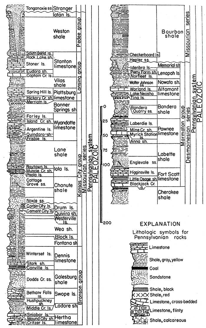
Mississippian System
Rocks of Mississippian age consisting of light-gray cherty limestone, medium to coarse crystalline in texture, crop out in the extreme southeastern corner of Kansas. The area of exposure is about 100 square miles, but in adjoining parts of Missouri and Oklahoma the outcrop area is very broad. These rocks contain the rich lead and zinc ores of the Tri-State district, and they contain commercial oil and gas accumulations in several Kansas fields. Late Mississippian rocks belonging to the Chesterian series occur a short distance south of the Kansas-Oklahoma line and probably extend a short distance into Kansas at the outcrop. They are important beneath the surface in much of Kansas. Total thickness of outcropping formations of the Mississippian in Kansas is about 50 feet.
Meramecian Series
The Mississippian limestones exposed in southeastern Kansas include some beds of Warsaw age that are classed as belonging to the Meramecian series.
Warsaw limestone--These limestones consist of bluish-gray cherty limestone containing glauconite near the base. They have been included in the so-called "Boone formation." The thickness of these rocks is about 15 feet.
A break in sedimentation that has considerable stratigraphic importance separates rocks of Meramecian age from older deposits.
Disconformity
Osagian Series
This division of the Mississippian system is mainly characterized by abundance of crinoidal remains and common occurrence of chert in the limestone beds. These limestones have an average thickness of 200 feet in Missouri
Keokuk limestone (?)--Light bluish-gray, fine- to medium-grained, cherty limestone, commonly in beds 0.5 to 2 feet thick, characterized by the common occurrence of fossil bryozoans along with other marine organisms. It has been included in the "Boone formation." Thickness about 35 feet.
No rocks older than Keokuk are known to be exposed at the surface in Kansas.
Figure 9--Generalized section of lower Pennsylvanian rocks in Kansas.
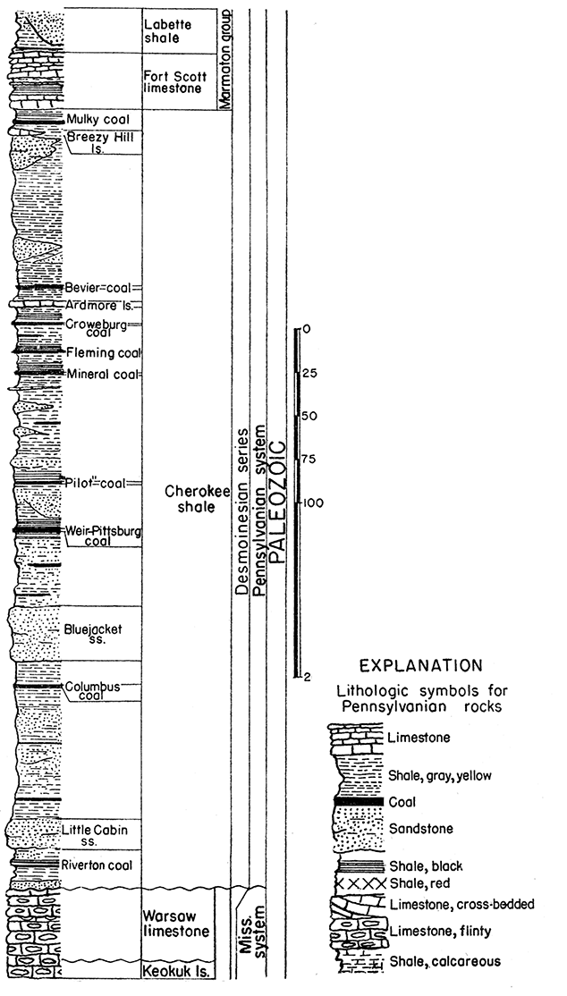
Prev Page--Mesozoic || Next Page--Igneous, Bibliography
Kansas Geological Survey, Geology
Placed on web Jan. 18, 2017; originally published Oct. 25, 1944.
Comments to webadmin@kgs.ku.edu
The URL for this page is http://www.kgs.ku.edu/Publications/Bulletins/52_4/05_paleo.html