![]()
Prev Page--Introduction || Next Page--Mesozoic
Cenozoic Rocks
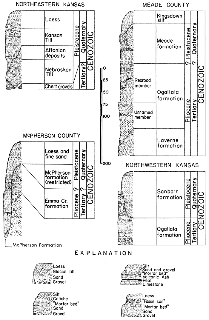
Formations belonging to the Cenozoic era; last of first rank geologic time divisions, are widespread in Kansas. They comprise Quaternary sediments, which include glacial deposits of northeastern Kansas and nonglacial deposits of Pleistocene and Recent time in all parts of the state, and Tertiary deposits, which cover most of western Kansas.
Quaternary System
Deposits of Quaternary age occur widely over Kansas. These are all nonmarine in origin and include glacial, fluvial, and eolian deposits. Glacial sediments occur only in northeastern Kansas, whereas stream-laid deposits occur generally in the western half of the state and along the valleys in the eastern half. The maximum aggregate thickness of these deposits is nearly 700 feet, but inasmuch as the maximum thickness of several units is never found in the same area the greatest thickness of Quaternary deposits known at any locality is 275 feet.
Recent Series (including some undifferentiated Pleistocene deposits)
Sedimentary deposits formed since the time of disappearance of the last glacial ice sheet from North America are classed as belonging to the Recent series. They are chiefly stream-laid deposits in continental areas such as Kansas, but on borders of continents they include marine sediments. Inasmuch as the last ice sheet did not reach Kansas and conditions that are typical of Recent time began in this region approximately in mid-Pleistocene time, the Pleistocene-Recent boundary in Kansas is not clearly recognizable at some places.
Alluvium
Gravel, sand, silt, and loam; gray to tan; underlying the valley flat of most stream valleys throughout the state. In western Kansas and along the through valleys of central and eastern Kansas the alluvium consists of sediments derived from the Rocky Mountain region mixed with local materials. In northeastern Kansas the alluvium is largely derived from glacial deposits; in southeastern Kansas it consists predominantly of chert gravel and sand and other material derived from the Paleozoic rocks of the region. Alluvium is generally thicker under major valleys and ranges in thickness from a few feet to more than 80 feet. Between Hutchinson and Wichita the alluvium of the Arkansas river valley attains a known thickness of 275 feet.
Dune sand
Eolian sand, well-sorted, predominantly quartz; gray to tan; mantling the surface of much of central and southwestern Kansas, especially in the Great Bend area, south of Arkansas river. The dune sand in many areas represents several cycles of dune development. The younger cycles are Recent in age and consist of loose sand, whereas the older cycles are Pleistocene in age and in some places are red-brown and are partly indurated. Maximum thickness, about 50 feet.
Loess
Eolian silt, well-sorted; gray, tan, buff, and red-brown. Widespread in western and central Kansas. Surficial loess is still in the process of deposition in some areas of the state, and in some places a thin mantle of Recent material overlies more widespread deposits of Pleistocene loess. Includes the upper part of the Kingsdown silt and the Sanborn formation. Maximum known thickness, about 25 feet.
? Unconformity ?
Pleistocene Series
The distinctive sedimentary deposits formed in Pleistocene time, which comprises the older and longer part of the Quaternary system, are glacial materials. Some glacial deposits, both those formed directly by ice work and those resulting from action of melt-water derived from ice sheets occur in Kansas, but they belong to the early and middle part of the Pleistocene epoch. Outside the glaciated area in early Pleistocene time and throughout the state during the latter part of the Pleistocene epoch, conditions resembled those of Recent time.
Pleistocene Series in Eastern Kansas
Loess
Eolian silt, massive, tan. Caps the uplands of northeastern Kansas, especially along the Missouri river valley. Maximum thickness, about 35 feet.
Terrace deposits
Sand, gravel, boulders, and silt; forming terraces along major stream valleys. In northeastern Kansas the terrace deposits are derived principally from glacial sediments and contain ice-carried pebbles and boulders of igneous rocks and quartzite. In southeastern Kansas these deposits consist of silt, clay, sand, and chert pebbles derived mainly from near-by Paleozoic rocks and high-level Tertiary deposits. Maximum thickness, about 80 feet.
Kansan till
Glacial till in northeastern Kansas, coarse-textured, brown and tan; containing boulders of rocks foreign to Kansas, especially pink quartzite. Thickness, a featheredge to 75 feet.
Aftonian interglacial deposits
Sand and silt in Atchison and adjacent counties; thin-bedded and thinly cross-bedded; tan and gray. Maximum thickness, in eastern Atchison County, 70 feet.
Nebraskan till
Glacial till in northeastern Kansas, fine-textured, blue-gray, contains few pebbles or boulders. Thickness, a featheredge to a maximum, near the Missouri valley, of 80 feet.
Major unconformity with Tertiary in Eastern Kansas
Pleistocene Series in Central Kansas
Loess
Eolian silt, well-sorted; tan, brown, and gray; locally, volcanic ash at base. Widespread in McPherson and Republic counties and mantles the uplands at scattered localities. Maximum thickness, in McPherson County, 110 feet.Gerlane formation
Clay, silt, sand, and gravel in south-central Kansas. Maximum thickness, in Barber County, 104 feet; thickness commonly 60 feet.
Terrace deposits
Sand, gravel, silt, clay, and volcanic ash; tan and gray. Mantles terraces of different ages which occur at heights of 10 to 100 feet above the flood plains of valleys of central Kansas, and underlies the floors of several abandoned high-level valleys. Some local terrace deposits have been called "Salt Creek gravel beds," and some deposits called "Abilene conglomerate" may be terrace deposits. Snails locally abundant. Representative mammals from terraces of three ages include: (1) Cynomys; (2) Castoroides, Neofiber, Blarina; (3) Sorex, Microtus, Pitymys. Thickness, thin veneer to 80 feet.
McPherson formation
Sand, gravel, and silt; gray and tan. Contains bones of mammals: Megalonyx, Paramylodon, Smilodon, Mastodon, Elephas, Parelephas, Equus, and Camelops. Thickness, a featheredge to 150 feet.
Belleville formation
Sand, gravel, silt, and clay, in Republic County. Contains Equus and Stegomastodon. Maximum thickness more than 150 feet.
Unconformity with Tertiary in Central Kansas
Pleistocene Series in Southwestern Kansas
Kingsdown silt
Silt and fine sand, containing nodules and bands of caliche; tan to gray. Thin-bedded fine sand at base grading upward into loess (Recent in upper part). Mantles uplands and covers floor of the Meade basin. Mammal remains include Paramylodon and Equus in lower part and Cynomys in upper part. Thickness, typically 10 to 45 feet, but attaining a maximum of more than 90 feet in southern Ford County; commonly 40 feet.
Terrace deposits
Gravel, sand, silt, and clay; mantling terrace surfaces at several levels along the Cimarron, Arkansas, and adjacent valleys. The deposits consist largely of pebbles and grains of Rocky Mountain rocks and abraded caliche and "mortar bed" pebbles. Contain bones of Parelephas and Equus. Thickness 5 to 65 feet.
Meade formation
Gravel, sand, silt, clay, volcanic ash, and caliche; gray, tan, red, pink, and buff; selenite crystals prominent in redbeds. Gravel and sand contain pebbles derived from the Rocky Mountain region and from near-by Pliocene and older rocks. Channel deposits rest unconformably on the lower, more widespread, part. Well exposed in the Meade basin. Snails locally abundant. Five distinct vertebrate zones have been recognized. The most typical mammals from these zones, in descending order, are: (1) Ambystoma, Sorex, Microtus; (2) Paramylodon, Equus, Camelops; (3) Sigmodon, Onychomys, Perognathus; (4) Sorex, Microtus, Pitymys; (5) Equus, Camelops. Thickness, commonly 10 to 150 feet.
Local unconformity with Tertiary in Southwestern Kansas
Pleistocene Series in Northwestern Kansas
Sanborn formation
Consists mainly of loess; sand and, locally, gravel occur commonly at the base; generally well-sorted, tan to gray-buff. Mantles the uplands and highest terrace levels. Snails are- abundant locally. From Jewell county westward to Decatur county a prominent soil zone that has yielded remains of Citellus and Cynomys occurs at the base of the gray-tan loess. Below the soil zone are heterogeneous deposits of clay, silt, sand, and gravel, usually red to red-brown in color. These deposits have yielded remains of the fossil vertebrates Citellus and Cynomys. Thickness 5 to 100 feet.
Unconformity with Tertiary in Northwestern Kansas
Tertiary System
Deposits of Tertiary age occur widely in central and western Kansas, and locally in eastern Kansas. These deposits are all continental in origin and were deposited mostly by streams and in lakes. The source area of most of these deposits was to the west, principally the area of igneous rocks in the Rocky Mountain region and the area of sedimentary rocks in eastern Colorado and western Kansas. The thickness of these deposits ranges from a thin veneer to about 350 feet, but the maximum thickness has nowhere been observed at the surface.
Pliocene Series
The Tertiary rocks of Kansas, so far as is known, are all included within the Pliocene series.
Pliocene Series in Eastern Kansas
Chert gravels
Gravel and sand; consist predominantly of p 0 0 r 1 y sorted chert gravels, brown to gray-tan, derived principally from the Flint Hills region of east-central Kansas. Underlie the surface of abandoned high-level valleys and high terraces. In northeastern Kansas these chert gravel deposits underlie the Nebraskan and Kansan tills. Pliocene or older in age. Thickness, thin veneer to 30 feet.
Major unconformity with Mesozoic in Eastern Kansas
Pliocene Series in Central Kansas
Emma Creek formation
Sand, gravel, sandy silt, and clay; brown, buff, and gray. Consists largely of pebbles and grains derived from adjacent Cretaceous rocks. Widespread in McPherson and adjacent counties. These deposits were probably deposited by streams flowing toward the south and southwest at a time prior to the establishment of east drainage across the Flint Hills region. A prominent disconformity occurs within the formation and the lower (older) part is probably equivalent in part to the Ogallala formation of western Kansas. The age of the beds above this disconformity is in doubt. They may prove in part to be of Pleistocene age. Mammal remains from the beds below the disconformity include Amebelodon, Tetralophodon, Neohipparion, Pliohippus, Nannippus, and Teleoceras. Thickness, less than 10 to 180 feet; commonly 40 feet.Major unconformity with Mesozoic in Central Kansas
Pliocene Series in Southwestern Kansas
Ogallala formation
Gravel, sand, silt, clay, and caliche; pink, gray, and tan. Widespread over western Kansas. Thickness, maximum, 350 feet, commonly 125 feet.
Rexroad member--Sand, silt, clay, caliche, and locally peat; gray, tan, and pink. Occurs in the Meade basin and vicinity. Contains mammals: Parahodomys, Sigmodon, Ogmodontomys, Plesippus, and Nannippus. The exact age of these beds within the standard time scale is in doubt. Snails locally abundant. Thickness (maximum thickness known only from well samples), less than 50 to 250 feet.
Unnamed middle Pliocene member--Gravel, sand, sandy silt, and caliche; massive to cross-bedded; pink, tan, and gray. Contains fossil mammals Amebelodon, Pliohippus, and Aphelops, and fruits of the herb Biorbia fossilia. Thickness, 10 to 150 feet, commonly 100 feet.
In Meade and Seward counties an angular unconformity at base.
Local unconformity
Laverne formation
Shale, sandstone, and limestone; buff, blue-gray, and gray. Silty chalky limestone contains ostracodes and diatoms. Snails locally abundant in shales. Mammal remains include Nannippus, Calippus, and Eucastor. Occurs in Meade and Seward counties, locally truncated by overlying Ogallala. Lower Pliocene and possibly upper Miocene in age. Exposed thickness 60+ feet; from well logs believed to attain a maximum thickness of more than 60 feet.
Major unconformity with Mesozoic in Southwestern Kansas
Pliocene Series in Northwestern Kansas
Ogallala formation
Gravel, sand, silt, and caliche; massive and cross-bedded; contains pebbles of igneous rocks (derived from the west), limestone, and sandstone; pink, gray, and tan. Gravel and sand locally cemented to form "mortar beds." Widespread under the High Plains of western Kansas. Locally capped by hard limestone or caliche bed containing algal-like structures. Contains Edson Quarry fauna and Biorbia fossilia fruits. Middle Pliocene in age. Green and red-brown bentonitic clay beds locally occur in the base of the Ogallala, and in Wallace county this zone has been called the Woodhouse clay. Locally this formation unconformably overlies undifferentiated lower Pliocene deposits (Norton, Rawlins, Phillips, and Trego counties) that have yielded bones of the fossil beaver, Eucastor. Thickness, 10 to 200 feet, commonly 150 feet.
Major unconformity with Mesozoic in Northwestern Kansas
Figure 2--Generalized sections of Cenozoic rocks in Kansas.
Prev Page--Introduction || Next Page--Mesozoic
Kansas Geological Survey, Geology
Placed on web Jan. 18, 2017; originally published Oct. 25, 1944.
Comments to webadmin@kgs.ku.edu
The URL for this page is http://www.kgs.ku.edu/Publications/Bulletins/52_4/03_ceno.html