Kansas Geological Survey, Bulletin 41, Part 9, originally published in 1942
Previous--Start Page | Next--Environment of Sedimentation
In order to classify the Cretaceous beds below the Greenhorn limestone in stratigraphic units that can be correlated over all of central Kansas, it has been deemed necessary to redefine the Cheyenne sandstone, the Kiowa shale, and the Dakota formation.
The Cheyenne sandstone, which is exposed only in south-central Kansas, is accepted in the same sense as used by Cragin (1890, 1891, 1895), Hill (1895), Gould (1900), and Twenhofel (1924). As defined by them, this formation includes sandstone strata of continental origin that lie unconformably on Permian rocks and that conformably underlie the Kiowa shale.
The name Kiowa shale is retained to designate the dark-colored marine shale, sandstone, and fossiliferous limestone, which occur above the Cheyenne sandstone and below the beds here included within the Dakota formation. This definition does not accord strictly with past usage, and reasons for the modification proposed by us will be given later.
The Dakota formation is restricted to include only the continental and littoral beds that occur above the Kiowa shale and below the Graneros shale. The upper and lower boundaries of the Dakota formation are not everywhere sharply defined, but they can be drawn within the limits of a 5- or 6-foot zone. Numerous sandstone layers and lentils are found in this part of the section. Despite the fact that these are mostly channel sandstones, possessing little continuity, some of them have been designated previously as individual stratigraphic units. Contrary to the general opinion of geologists, the Dakota deposits of central and north-central Kansas do not consist predominantly of sandstone. Sandstone is present and locally very prominent, but clay is quantitatively the most important type of sedimentary material in the formation.
The Dakota formation is divided into parts, the lower of which is named the "Terra Cotta clay member" and the upper, the "Janssen clay member." The Terra Cotta member is defined to include massive clay, silt, and sandstone comprising approximately the lower two-thirds of the Dakota formation. The most conspicuous lithological feature of the Terra Cotta member is the widespread distribution of gray-and-red-mottled massive clay. The Janssen member includes beds of lignite, gray to dark-gray massive clay, silt, and some shale above the Terra Cotta member and below the Graneros shale. The Janssen-Terra Cotta contact is not a sharp one, but in most places it can be drawn within a 5-foot zone. The contact is arbitrarily placed by us at the top of a zone of concentrated concretionary siderite, limonite, or hematite, which is overlain by a bed of gray massive clay containing varying amounts of siderite (possibly ankerite, in some cases) pellets and with yellow to yellow-orange coloring along oblique joints.
Where the base of the Cretaceous is exposed in Kansas, it lies unconformably upon a mature erosional surface that is developed on various Permian rocks. As much as 50 feet of relief has been noted on this unconformable surface. Differential compaction of the Cretaceous beds over the Permian hills and valleys is evident in some places, and this may produce rather pronounced local structure that is not found in the older beds.
At several places, a zone of weathering or leaching was noted in the upper few feet of the Permian shale. Normally, the Permian shale in the areas studied ranges from dark brownish-red to greenish-gray. In the leached zone the colors are lighter buff or yellow in some places. Where observed on single exposures the depth of this leached zone is uniform, and its base cuts across bedding planes.
At many places the Permian-Kiowa or Permian-Dakota contact is a smooth shale-on-shale contact, and no trace of coarse material is present. Elsewhere, a narrow zone is found that contains well-rounded and, in some places, polished pebbles or cobbles up to 3 inches in diameter. The pebbles consist of quartzite, chert, and, rarely, limestone. Generally, they are found imbedded in friable sand, which may contain some lignite particles, but they are also enclosed by shale where sand is absent. Although this zone is mostly quite thin, a thickness of three or four feet was observed in Clay county (pl. 1B). This zone is not confined to areas showing the Permian-Kiowa contact, since it has been found under the Dakota formation in northern Clay county; and, according to Frye (personal communication), the same zone occurs under the Cheyenne sandstone formation in southern Kansas. This material may have been residual on the Permian surface prior to the invasion of the Cretaceous sea. More probably, however, it represents the earliest continental deposits of Cretaceous age. This unnamed bed warrants careful future study.
The Cheyenne sandstone was described by Cragin (1889, from exposure at Cheyenne rock, near Belvidere in southeastern Kiowa county, Kansas). The type exposure consists of 40 feet of crossbedded, loosely cemented sandstone interbedded with shale, resting on red beds of Permian age. The overlying strata consist of dark shale of marine origin classed as Kiowa shale.
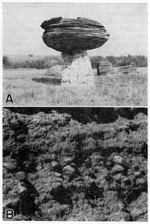
Plate 1--A. Typical ellipsoidal concretion of "quartzite" in the Dakota formation, sec. 30, T. 15 S., R. 6 W., Ellsworth county. B. Pebble zone at base of Cretaceous beds, SE sec. 9, T. 10 S., R. 1 E., Clay County.
The Cheyenne sandstone is extensively distributed in the subsurface of western Kansas, as indicated by study of well samples; and it occurs also in central Kansas but does not crop out in the area studied. The Cheyenne formation is considered to be of continental origin. Plant remains, particularly leaves of dicotyledons, occur in the sandstone, but no marine fossils have been found. The Cheyenne has been described in some detail in several previous reports (Cragin, 1890, 1891, 1894, 1895; Hill, 1895; Gould, 1900; Twenhofel, 1920, 1924; Latta, 1941).
The Kiowa shale was named in 1894 by F. W. Cragin (p. 49) and described as those dark and light colored fossiliferous shales overlying the Cheyenne sandstone or the Permian "redbeds" and overlain by brown sandstone, of middle Cretaceous age, or by Tertiary or Pleistocene deposits. The name was derived from Kiowa county southwestern Kansas.
In the area investigated, the Kiowa shale crops out as far south as McPherson and Rice counties and as far north as Clay county. It thins toward the northeast and disappears entirely in Clay county. From there, north to the Nebraska line, the Dakota formation immediately overlies Permian shale and limestone. The Kiowa shale consists of dark gray fissile clay-shale containing selenite crystals, bands of "ironstone," and cone-in-cone, and nearly white to brown sandstone. The beds of sandstone commonly consist of fine-grained and horizontally thin-bedded quartz sand. Some of them contain glauconite, pyrite, and lignitized logs or sticks. Molds of marine shells have been observed in the sandstone in the northeast comer of Rice county and in Saline county. Fossiliferous limestone beds also occur in the Kiowa. The Champion shell bed occurs at the base of the Kiowa shale in the type locality. This is the only limestone in the Kiowa shale that has been assigned a definite stratigraphic name.
The Kiowa shale closely resembles the Graneros shale in appearance and in ceramic and chemical properties. Like most marine shales that have not been subjected to prolonged weathering and leaching subsequent to deposition, the dominant clay mineral is illite. The illite is associated with varying amounts of montmorillonite. Iron is commonly found to be an integral constituent of the clay molecule in the minerals of these groups. Finely divided carbonaceous material and a considerable amount of pyrite indicate that reducing, rather than oxidizing, conditions prevailed subsequent to the deposition of the muds that formed the Kiowa shale. The significance of this fact in connection with the formation of clay minerals is that the movement of fresh water at or near the surface, which is essential to the formation of kaolinite, could not occur under reducing conditions. The dark-gray Kiowa shale, when fired in the kiln for ceramic tests, turns brown or red-brown, whereas the kaolinitic clay from the Dakota formation, which has the same natural color and appearance as that from the Kiowa, fires to a cream or buff color. The shale is further characterized by a high absorption of water, high shrinkage from drying and firing, and a comparatively low fusion point. A comparison of the ceramic properties in relationship to the lithology of the marine and nonmarine clay and shale will be treated more fully in the discussion of the Dakota formation.
The maximum thickness of Kiowa shale, measured on the outcrop in the north-central Kansas area, is 60 feet. No outcrops of this formation were found, however, where the entire thickness, including the Permian and Dakota contacts, was exposed. It is estimated from composite sections that the maximum thickness of the Kiowa, in the region studied, is 100 to 125 feet. In a water well drilled on the Sherman ranch in Ellsworth county, in the NE cor. sec. 15, T. 17 S., R. 7 W., the Kiowa-Dakota contact was reached at 35 feet below the surface. The well was drilled through 113 feet of Kiowa shale before reaching the top of the Permian.
The following section was measured from a fresh exposure at the west portal of the Kanapolis dam, NW sec. 2, T. 17 S., R. 6 W., in southeast Ellsworth county. The Kiowa-Dakota contact is not included in this measured section, but was observed on the hills to the west and northwest.
| Section Measured From a Fresh Excavation at the West Portal of the Kanopolis Dam (NW sec. 2, T. 17 S., R. 6 W.), Ellsworth County | ||||
|---|---|---|---|---|
| Cretaceous system | Thickness (feet) | |||
| Kiowa shale | ||||
| 8. Sandstone, fine-grained, yellow, thin-bedded | 5.0 | |||
| 7. Shale, shaly silt, and sandstone, gray, with some gypsum crystals | 8.8 | |||
| 6. Shale, fissile, dark gray, a thin cone-in-cone bed near middle | 3.8 | |||
| 5. Limestone, gypsiferous, fossiliferous, overlain by cone-in-cone | 0.4 | |||
| 4. Shale, fissile, dark gray, selenite and a thin cone-in-cone layer in the lower half, a band of concretionary "ironstone" at the bottom | 11.8 | |||
| 3. Shale, fissile, dark gray, with a small amount of gypsum, and a few very thin, irregular sandstones | 18.1 | |||
| Total thickness exposed | 47.9 | |||
| Unconformity | ||||
| Permian system | ||||
| (?) Ninnescah shale | ||||
| 2. Silt, clayey, light gray, massive to imperfectly laminated. This light-colored shale is uniform in thickness at this exposure but it cuts across bedding planes at the bottom, indicating that this is a pre-Kiowa weathered zone in the Permian | 2.0 | |||
| 1. Silt and shale, banded red and gray | 16.0 | |||
South of Kanopolis the following section was measured from below water level in Thompson creek to the top of a steep hill south of the creek. This is in the S2 NW sec. 28, T. 16 S., R 7 W., Ellsworth county. The section was measured in pits excavated to obtain samples for ceramic tests. Measurements were checked by instrumental elevation at the top of each pit.
| Section On Thompson Creek, Near Kanopolis, Kansas | ||
|---|---|---|
| Dakota formation | Thickness (feet) | |
| 17. Clay, massive, very light gray to cream | 1.9 | |
| 16. Clay, massive, silty, yellow and gray, with abundant pellets of limonite and hematite | 3.2 | |
| 15. Clay, silty, massive, gray and yellow | 2.5 | |
| 14. Sandstone, fine-grained, yellow, buff and brown, horizontally bedded and crossbedded; contains imprints of dicotyledon leaves. Top of sandstone dips to west and a little north | 13.5 | |
| Total thickness of Dakota formation exposed | 21.1 | |
| Kiowa shale | ||
| 13. Clay and clayey shale, gray; like bed 12, but lighter in color, and may represent a pre-Dakota zone of weathering | 5.6 | |
| 12. Clay-shale, dark gray and yellow; a band of concretionary "ironstone" near bottom; scattered ellipsoidal discs of "ironstone, and an unusually large amount of gypsum | 5.4 | |
| 11. Silt and sandstone, yellow to gray, thin-bedded, contains limonitic sandy concretions, pyrite, and selenite crystals; a concretionary "ironstone"-band at top | 6.6 | |
| 10. Clay, massive, dark gray; contains powdery sulphur (?) and small selenite crystals in joints | 1.4 | |
| 9. Shale, clayey, and gray and white silt alternating in paper-thin laminations; contains some gypsum | 1.3 | |
| 8. Shale, clayey, dark gray, bearing thin streaks of yellow and gray sand and silt; contains large crystals of gypsum and some sulphur (?) along joints | 8.7 | |
| 7. Shale, clayey, dark gray, containing a small amount of gypsum | 1.2 | |
| 6. Silt, shale, and sandstone, thin-bedded to fissile, gray, buff, and yellow; contains pyrite zones; uppermost one foot irregularly bedded | 12.3 | |
| 5. Shale, clayey, dark gray; cone-in-cone and concretionary "ironstone" beds near middle | 5.7 | |
| 4. Silt, gypsiferous, having cone-in-cone structure; a thin fossiliferous limestone at the base | 0.7 | |
| 3. Shale, clayey, dark gray; contains "ironstone" concretions and imprints of marine shells | 5.1 | |
| 2. Silt, gray, with clay streaks, cone-in-cone at top, and pyrite near middle; contains marine fossil imprints | 1.8 | |
| 1. Shale, clayey, dark gray; contains a lignitized log having pyrite in cracks | 1.4 | |
| Total thickness of Kiowa shale exposed | 57.2 | |
The Kiowa-Dakota contact as here exposed is not typical. The contact can usually be identified by a gray silt or fine sandstone at the base of the Dakota formation; this layer is evenly bedded, at least in the lower portion; and, commonly, it contains large ellipsoidal concretions of "quartzite" and some pyrite (pl. 1A). It is probable that bed 14 of the Thompson creek section is a local channel filling that has replaced the original material partly or wholly; the strata at this horizon, if not "quartzitic," are friable or clayey and, therefore, easily eroded. Bed 15 and bed 16 of the Dakota formation are useful key beds in determining the Kiowa-Dakota contact. This relationship of a gray massive clay, below a strongly colored, generally red, yellow, and gray, mottled clay, bearing concretionary iron pellets, is a fairly constant one.
About a half-mile north-northwest of the location of the Thompson creek exposure, several feet of Kiowa shale is exposed in a road cut between the SW cor. sec. 21 and the SE cor. sec. 20, T. 16 S., R 7 W. The shale is overlain by the Dakota and the beds are folded and faulted. A well-defined overthrust fault is exposed on the west side of this cut. A brown and yellow sandstone, which is the lowermost Dakota bed at this place, lies unconformably on folded and truncated strata of the Kiowa. The contact is nearly horizontal but shows minor pre-Dakota erosional inequalities. This is one of two instances known to us in which an erosional unconformity is identifiable at the Kiowa-Dakota contact. Here, the irregularity of the surface of the Kiowa is probably due to stream erosion prior to the deposition of a local channel sandstone at the base of the Dakota.
The Kiowa shale becomes thinner to the northeast along the outcrop. It is absent in parts of Ottawa and Clay counties, and probably entirely missing in Washington county (fig. 4). Owing to irregularities of the Permian surface, formed by erosion before Kiowa and Dakota deposition, the thinning of the Kiowa shale is equally uneven. For example, in the SW sec. 34, T. 11 S., R. 1 W., Ottawa county, the Dakota formation immediately overlies Permian shales; whereas, four miles farther north, in the SW sec. 10, T. 11 S., R. 1 W., a thickness of 40 feet of Kiowa shale was measured. Although the Permian-Kiowa contact is not exposed at the latter outcrop, it is likely that it is only a few feet below the bottom of the measured section. The Kiowa-Dakota contact is seen here, and, therefore, the 40 feet of Kiowa shale probably represents nearly the maximum thickness at this place.
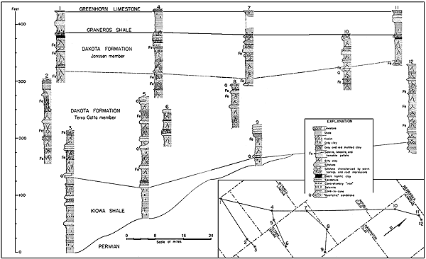
Figure 4--Correlated outcrop sections of the Cretaceous beds of central and north-central Kansas. A larger version of this figure is available.
The methods of study which must be used on the Dakota formation are different from those that have been employed successfully in study of marine Cretaceous sediments. The resistant, conspicuous beds of the Dakota formation are sandstone which is not horizontally continuous and, therefore, is not useful in stratigraphic studies. Furthermore, the persistent beds of clay are commonly weathered or covered; they are notably inconspicuous. The general lack of fossils in the continental beds is a handicap to detailed stratigraphic work. The uniformity in characters of clay and silt beds of the Dakota formation is not the same type of uniformity that is found in many marine sedimentary rocks. Striking lateral variations of the Dakota strata, in thickness, color, and texture of the beds, may be observed even on a single exposure. It is only after study of many exposures and acquisition of a certain familiarity with the Dakota sediments that an orderly cyclic succession of beds can be detected. This orderly succession is chiefly expressed by the distribution of beds having a concentration of siderite, limonite, or hematite pellets.
The Dakota formation of Kansas, as here defined, has been called, variously, "Dakota group" (Meek and Hayden, 1862); "Dakota formation" (Twenhofel, 1924); "Ellsworth and Solomon formations" in a classification by Tester which was published in Rock Formations of Kansas, by Moore; "Rocktown channel sandstone member" (Rubey and Bass, 1925); "Dakota sandstone" (Prosser, 1897), and many others. The Dakota group (Meek and Hayden, 1862) was defined to include the sandstones, various colored clays, and lignite beds which underly the Benton group in eastern Nebraska. The beds were named from exposures near Dakota City, in Dakota County, Nebraska. These beds were believed by Meek and Hayden to extend into northeastern Kansas.
The Dakota formation is here defined to include the Cretaceous strata from the top of the Kiowa shale formation, below, to the base of the Graneros shale, above. At no place in the region studied is the entire thickness of the Dakota continuously exposed. In the area within a radius of a mile from Terra Cotta station, in eastern Ellsworth county, however, almost the entire thickness of the Dakota formation can be seen. Also, the Kiowa-Dakota contact, with several feet of the underlying Kiowa shale, is well exposed near the Salina-Ellsworth county line.
In most of the literature describing the Dakota formation, great emphasis has been placed on the channel sandstone, which is a minor, although conspicuous, feature of the formation. This is understandable, inasmuch as the clay, silt, and fine, thin-bedded sandstone are mostly non-resistant, and, unless exposed by recent erosion or in artificial cuts, are covered by soil and overgrown with vegetation; whereas, the more resistant sandstone caps the hills and covers the slopes with residual sand and slumped fragments. It is only from pits or other artificial exposures that adequate data concerning the Dakota formation as a whole can be obtained. It seems certain that the channel sandstones are in no case confined to any particular horizon within the formation; and, if they are given stratigraphic names, they should be described as lentils. Thin, persistent beds of very fine-grained clayey sandstone and silt are commonly found in the Dakota. These beds are usually light-colored and should be considered as coarser facies of the clays. In fact, such beds of silt and fine sand which have been sampled are sufficiently argillaceous to permit their being molded into bricks and tested like a clay.
In some places the coarser sandstone has the appearance of being relatively thin and horizontally persistent. This seems particularly true of sandstone that caps a series of hills. Where such occurrences have been studied in detail, it was found that the capping sandstone occupies different stratigraphic positions, although the dark, case-hardened sandstone on the hill top has the appearance of being thin, horizontally persistent "sheets."
Despite expressed qualifications and warnings, the geologist is prone to fix his eye on resistant beds in a published columnar section. For this reason no channel sandstone is described in the following generalized section of the Dakota formation. Any one desirous of doing so may insert a lenticular sandstone in any portion of the section and be reasonably assured that such a sandstone occurs at that stratigraphic position somewhere in the area of the outcrop.
| Generalized Section of the Dakota Formation in north-central Kansas | |||
|---|---|---|---|
| Graneros shale | Range of thickness in area discussed (feet) | ||
| Shale; dark, fissile; contains rusty, yellow to brown partings, selenite crystals, and, locally, channel sandstones; marine fossils present | 21.0 to 40.0 | ||
| Dakota formation | |||
| Janssen clay member | |||
| 17. Limonite, siderite, or hematite, concretionary, associated with some silt or fine sand; may be a difficultly discernible bed, or a part of a transitional bed grading from typical Dakota to typical Graneros | 0.1 to 5.0 | ||
| 16. Siltstone, gray to light gray, commonly fairly resistant; contains fragments of lignitized wood, some fossil leaves, and small vertical channels, some of which look like worm borings and others like molds of stems or roots. This zone generally contains much limonite or siderite, and, in a few cases, lignitized stems or roots. In some small areas a channel sandstone occupies this horizon | 0.5 to 4.0 | ||
| 15. Lignite and black lignitic clay; this bed may be massive or shaly | 0.1 to 4.0 | ||
| 14. Clay, silty, gray, plastic, and some silt; typically medium gray in color; contains lignite particles and an abundance of fossil leaves. Locally, this zone is occupied by rather uniform dark to medium gray silty shale. All samples taken from this bed are fireclays | 15.0 to 30.0 | ||
| 13. Clay, mottled, gray and light red, lithologically similar to overlying bed except for greater percentage of ferric iron. This bed is missing in many places, or, locally, it is lenticular | 0.0 to 10.0 | ||
| 12. Clay, silty to plastic, gray, stained yellow or orange yellow, especially on and adjoining irregular oblique joints. The clay is massive and breaks with a conchoidal fracture. One or two zones of limonite or siderite pellets are commonly found in this clay | 15.0 to 30.0 | ||
| Terra Cotta clay member | |||
| 11. Clay or silt containing an abundance of concretionary iron in the form of siderite, limonite or hematite "shot." The iron is sufficiently concentrated in many places to form a resistant bed | 0.1 to 4.0 | ||
| 10. Clay, massive, locally silty; this zone may or may not be stained yellow or mottled red | 0.0 to 10.0 | ||
| 9. Silt and sandstone, very fine, gray or yellow, generally thin-bedded and containing lignite particles. In many places this bed is "quartzitic," or contains ellipsoidal concretions of "quartizite," but it may be missing entirely, bed no. 11 of the Janssen member occurring immediately above it | 0.0 to 10.0 | ||
| 8. Clay, massive, gray, of fireclay type; commonly contains some fossil leaves and lignite particles | 1.0 to 5.0 | ||
| 7. Clay, massive, lignitic, dark gray; contains fossil leaves | 0.1 to 3.0 | ||
| 6. Clay, mottled gray and red, massive, of the fireclay type obliquely jointed irregularly and breaking out with a conchoidal fracture. This zone contains economically important beds of gray fireclay having a high alumina and low iron content. Some seemingly persistent zones of concretionary iron in the form of of limonite, siderite, or hematite pellets, or of granular hematite, occur in this division. There are also some thin beds of sandstone and silt, not channels or bars, in which "quartzite" concretions are commonly found | 100.0 to 150.0 | ||
| 5. Clay to clayey silt, mottled gray, red, and yellow, having an abundance of limonite, siderite, or hematite pellets, or granular hematite; the granular hematite is most common | 1.0 to 6.0 | ||
| 4. Clay, mottled light gray and red, kaolinitic, gradational contact at top and bottom | 1.0 to 5.0 | ||
| 3. Kaolin, white; does not slake readily, and appears as a band of white fragments on weathered surface. At some places this bed is not evident on exposures, but generally it can be identified by ceramic tests and chemical analyses | 0.1 to 1.5 | ||
| 2. Clay with silt, gray to dark gray, or fine sandstone bands, lignite and fossil leaves common. In some sections portions of this bed are shale or thin-bedded clay. A highly lignitic, darker band commonly occurs toward the bottom, and pyrite, also. This bed is mostly a refractory fireclay; and, unless yellow stain is marked, samples fire to ivory or cream colors | 5.0 to 30.0 | ||
| 1. Siltstone and fine sandstone, mostly thin-bedded, but locally crossbedded; this zone characteristically contains "quartzite" concretions, which, if not quartzitic, are likely to be very friable. Fossil leaves, fragments of lignite, and nodules are common. This zone is missing in places, in which case Dakota clay (bed 2) rests directly on Kiowa shale or older rocks | up to 20.0 | ||
| Kiowa shale | |||
| Shale, dark gray, in some cases indistinguishable from the Dakota clay or shale except by ceramic or other tests that show the mineralogical characteristics of the two. | |||
Beds 1 to 5, as described in the generalized section of the Dakota formation, constitute a valuable series to aid in locating the Kiowa-Dakota contact in the field. Bed 5 is commonly conspicuous, even from a distance, particularly if the iron in the bed weathers out as granular hematite. The base of the Dakota is placed arbitrarily at the base of the "quartzite"-bearing siltstone or sandstone described as bed 1. In many cases a few feet of light-colored clay that occurs below this bed on a lithological basis possibly should be classed with the Dakota. Such an inconspicuous contact would be difficult to find on the usual weathered exposures, however. The "quartzite" concretions (pl. 1A), on the other hand, are easily detected even on weathered exposures. The contact cannot be identified positively unless the dark fissile shale of the Kiowa can be found below the "quartzitic" bed 1, inasmuch as a series of beds resembling those from 1 to 5 occurs somewhat higher in the Terra Cotta member.
Terra cotta clay member.--The entire section of the Terra Cotta clay member is exposed in the school district of Terra Cotta, comprising part of T. 15 S., R. 6 W., in the east-central part of Ellsworth county, Kansas. Practically the entire section was uncovered by pits dug on the side of a steep hill (SW sec. 14, T. 15 S., R. 6 W.), north of the abandoned village of Terra Cotta, which is now only a cattle-loading siding on the Union Pacific railroad. The main street of the once thriving village probably marked the base of the Terra Cotta member. Several good exposures of the Terra Cotta clay can be seen on both sides of Highway U.S. 40, from the Saline-Ellsworth county line to Carneiro. On the slope to the west side of a pond on the Vanier Ranch (SW sec. 18, T. 15 S., R. 5 W.), one mile south of highway U.S. 40 on the Saline-Ellsworth county line, the Kiowa-Dakota contact is fairly well exposed. Also, the lower 120 feet of the Terra Cotta member is fairly well exposed on the west side of "Needle's Eye" hill just south of U.S. 40, in the center of the east line, NE sec. 15, T. 15 S., R. 6 W. The upper 34 feet of this section, however, is a typical channel sandstone, which has its maximum thickness near the Vanier pond. South of highway U.S. 40, the axis of this channel trends southwestward; but, north of the highway, the channel curves to the northwest, or a tributary enters it near this point. A good exposure of typical Dakota strata, consisting of gray and red mottled, massive clay, may be observed two miles west of the "Needle's Eye," along the road cuts of highway U.S. 40 where it turns southwestward toward Carneiro.
The largest and most interesting exposure of the Dakota-Kiowa beds can be observed in the north bluffs of the Smoky Hill river valley, near cen. SW sec. 1, T. 16 S., R. 7 W. Here, about 50 feet of Kiowa shale and 140 feet of the Terra Cotta clay member of the Dakota formation are exposed. This exposure is somewhat confusing, however, owing to extensive slumping of the cliff. Many good outcrops of both the Kiowa shale and the Dakota formation were found in central and north-central Kansas.
The upper 100 to 125 feet of the Dakota formation is well exposed along the Saline river escarpments from north of Russell to the point where this river enters Lincoln county, southwest of the town of Sylvan Grove. The western bluffs of the river valley, from near the mouth of Hell creek to the Lincoln County line, afford an opportunity to study a characteristic channel sandstone at the top of the Dakota. This channel sandstone becomes thinner and disappears at the southwest and northwest extremes of this series of exposures, but reaches a maximum thickness of about 30 feet near the center.
The greatest development of the "quartzitic" facies of the sandstone occurs near Lincoln, where the "quartzite" is extensively quarried. The "quartzite" occurs in the Terra Cotta member. Exposures along Kansas highway 14, from Lincoln north, to the top of the valley escarpment, reveal a section comprising beds from below the Terra Cotta-Janssen contact to the Lincoln limestone member of the Greenhorn limestone.
Comparison of the upper 140 feet of the Dakota formation in two other Lincoln County exposures is of interest. At "Hell's Half Acre," 2 miles north of Kansas highway no. 18, in the NW sec. 36, T. 11 S., R. 7 W., an abnormal amount of red mottling occurs both in the Terra Cotta and Janssen members; whereas, in the SW sec. 33, T. 13 S., R. 7 W., as shown by several exposures, the Janssen consists almost entirely of silt and very silty clay. One 40-foot bed of lithologically uniform silty clay was sampled in this area.
About 60 feet of beds belonging to the middle part of the Terra Cotta member are exposed on the south bank of a creek in the SW sec. 1, T. 11 S., R. 6 W. These beds are tentatively correlated with those reported in tables 1 and 2.
The upper 135 feet of the Dakota formation is partially exposed along the county road crossing Boyer's hill, west of Delphos (SE sec. 14, T. 9 S., R. 5 W.). The Dakota-Graneros contact and the Greenhorn limestone are shown here. Covered portions of the Dakota section along the road are represented by exposures on hill slopes a quarter to half a mile north of the road, in the NW sec. 14, T. 9 S., R. 5 W., Ottawa County.
A composite section showing nearly the entire thickness of the Dakota formation can be measured from the numerous exposures on hills a short distance west and northwest of Miltonvale, Cloud County. A good example of extreme irregularity in bedding may be seen in outcrops of Dakota strata along U.S. highway 24, near the cen. S line, sec. 14, T. 8 S., R. 2 W. This area has been described briefly by Wing (1930, p. 31-34).
The Dakota formation is well exposed in Washington County, north of the city of Washington, particularly in T. 1 S., R. 3 E. and westward from Morrowville to the county line. The Janssen member and the upper portion of the Terra Cotta member are clearly exposed at several places south of Haddam in the S2 sec. 27, and N2 sec. 34, T. 2 S., R. 1 E. In the E2 sec. 14, T. 1 S., R. 3 E., the greater part of the lower half of the Dakota formation is exposed. The W-5 beds, to which reference is made below, make up a portion of this section.
The Kiowa shale has not been found on any outcrops observed in Washington County. The Permian-Dakota contact is well exposed near the west end of the bridge across the Little Blue river at Hollenberg. The Permian strata that occur here, next below the Dakota formation, are considerably older than the red beds of Permian age that underlie the Cretaceous in Ellsworth and Rice counties. The youngest Permian of the Little Blue river outcrops belongs in the lower part of the Wellington formation, about 1,000 feet stratigraphically below the youngest exposed Permian in Ellsworth county. A much thicker section of Permian and Dakota beds is exposed near the cen. 1 1/2 sec. 35, T. 2 S., R 4 E. Irregularities in elevation of the Permian-Dakota contact, which are found along U.S. highway 36, 2 to 3 miles east of Washington, are interpreted to define the topographic unevenness of the original Permian surface.
Future study may justify subdivision of the Terra Cotta clay member of the Dakota, as here defined. Relatively few of the detailed sections which were measured in pits excavated for the collection of clay samples have been studied and compared closely. Judging from those already studied, however, we may recognize two or three beds marked by strong concentration of concretionary iron that occur at regular stratigraphic intervals. The succession of strata occurring below or above these ferruginous beds is similar to beds 1 to 5 of the generalized section of the Dakota formation. This succession of beds possibly represents depositional cycles which can be used in determining more exactly the environment of sedimentation of the Dakota formation. The concretionary iron beds were attentively noted in the field, both because they are relatively conspicuous in the outcrops and because high grade fireclay commonly underlies the iron-bearing beds. The fireclay samples have a high content of alumina, and many of them contain thin streaks of kaolin and lignite. In our opinion we have been able to identify one fireclay bed of this type from outcrops as far apart as north-central Washington County and east-central Lincoln County. Tables 1 and 2 show the nearly identical ceramic and chemical properties of samples of this fireclay bed taken from outcrops separated by a distance of over 50 miles. Location W-5 is in the SE sec. 14, T. 1 S., R. 3 E., Washington County; location C-27 is near the cen. S2 sec. 32, T. 8 S., R. 2 W., Cloud County.
Table 1--Ceramic data on two samples of the Terra Cotta clay member from Cloud and Washington counties, Kansas.
| Sample no. | Volume shrinkage on drying (%) | Volume shrinkage on firing to 2200° F | Specific gravity at same temperature |
|---|---|---|---|
| W-5 | 26.6 | 24.1 | 2.41 |
| C-27 | 26.5 | 25.3 | 2.40 |
Table 2--Chemical analyses of two clay samples of the Terra Cotta clay member from Cloud and Washington counties, Kansas.
| Constituents | Sample W-5 | Sample C-27 |
|---|---|---|
| Silica (SiO2) | 59.88% | 59.94% |
| Alumina (Al2O3) | 30.90 | 29.38 |
| Iron oxide (Fe2O3) | 1.69 | 1.20 |
| Calcium oxide (CaO) | 0.24 | 1.10 |
| Loss on ignition | 7.26 | 8.40 |
Clay samples W-5 and C-27 are very similar in appearance at the outcrop and in freshly excavated pits. Both are platy or thin-bedded in part, and contain well-preserved imprints of dicotyledonous leaves; both are overlain, by light gray and red mottled clay that grades upward into a highly hematitic clay, and they are underlain by gray silty, lignitic clay. We believe that this bed is stratigraphically continuous across the entire outcrop area. Tentative correlations of outcrops in several localities have been made by the methods briefly described.
The physical and chemical properties, as indicated by ceramic tests and chemical analyses, have been used in stratigraphic investigation of the Dakota strata because they reveal lithological characters of the clay and shale that have value for correlation. Lithologic differences in beds or parts of beds reflect variations in the environment of deposition, and these differences provide the primary basis for stratigraphic subdivisions proposed in this study.
Janssen clay member.--The Janssen clay member of the Dakota formation, as here classified, includes the 30 to 80 feet of beds lying next below the Graneros shale. The type area of the member is near Janssen Station (cen. S line sec. 3, T. 16 S., R. 9 W.), Ellsworth County. As described in the generalized section of the Dakota formation, the Janssen member consists largely of gray to dark gray clay and silt, some beds of fissile shale, and commonly a bed of lignite or highly lignitic clay. The gray clay in the lower half of the member, as shown in the section, is generally stained yellow or orange-yellow, and it contains zones of siderite or limonite pellets, but no hematite. The contact between the Terra Cotta and Janssen members is drawn at the top of a marked concentration of concretionary "iron." In many places a "quartzitic" silt or fine sand underlies the concretionary "iron" bed. It is believed that the presence of the "quartzite" is due to the fact that the conditions favorable to cementation are distributed at definite horizons and that, whenever a sufficiently permeable bed occurs, a "quartzite" is formed at this horizon.
In the type area of the Janssen clay, the member approaches the minimum observed thickness. The Janssen member differs in appearance from the Terra Cotta member, owing to prevalence of gray-and-red mottled clays in the latter; but, for the difference in color, the two members are lithologically very similar. Shaly structure is more commonly found in the Janssen than in the Terra Cotta clay member, but, in both, the clays are generally massive. Oblique joints intersect the clayey beds at random, and in excavations below the surface the clay breaks out with a conspicuously conchoidal fracture (pl. 2B). The dominant clay mineral is kaolinite; very finely divided quartz is also common. As much as 95 percent of many of the silt beds, which are 85 to 95 percent silica, will pass through a 200-mesh sieve. The gray to dark gray silts and silty clays, especially the thin-bedded ones, are more characteristic of the Janssen clay member than of the Terra Cotta clay member.
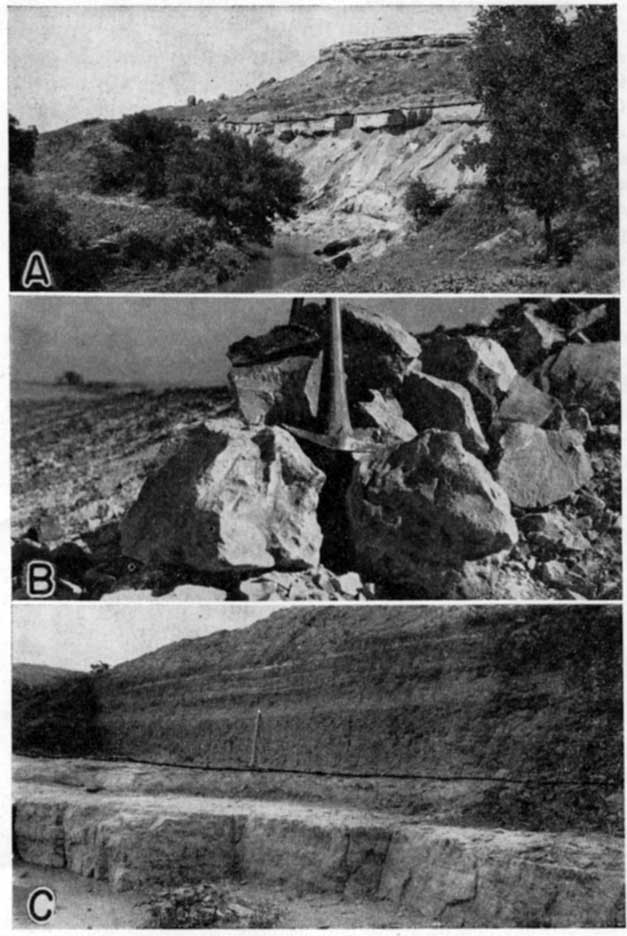
Plate 2--A. Outcrop of Janssen clay member of the Dakota formation. Shows resistant upper siltstone (black line indicates top), underlain by massive clay. Graneros shale and Tertiary beds crop out on the slope above the siltstone. Cemented Tertiary conglomerate caps the hill. B. Freshly excavated massive clay from the Janssen clay member. Shows conchoidal fracture. C. Contact of the upper Janssen siltstone and Graneros shale. Dark line indicates contact.
The essential difference between the Janssen and the Terra Cotta clay members is a dissimilarity in bedding, the stratification of clayey material being definitely more regular in the Janssen member. This indicates that the conditions of sedimentation were more stable at the time of deposition of the Janssen beds. Inasmuch as the change from somewhat unstable conditions of sedimentation during the time of Terra Cotta deposition to more stable conditions in Janssen time was gradual rather than abrupt, the line of demarcation between the two members must be drawn arbitrarily. The following section is exposed in the SW sec. 2, T. 16 S., R. 9 W., one-half to three-fourths mile east and northeast of Janssen Station.
| Section in the Type Area of the Janssen Clay Member, sec. 2, T. 16 S., R. 9 W., Ellsworth County | |||
|---|---|---|---|
| Graneros shale | Thickness (feet) | ||
| Shale, dark, fissile, unusually free from thin sandstone. | |||
| Dakota formation | |||
| Janssen clay member | |||
| 12. Siltstone, clayey, gray, bearing vertical worm borings or root molds | 0.8 | ||
| 11. Clay, lignitic, black | 0.2 | ||
| 10. Silt, clayey, gray, containing some irregular yellow bands | 3.0 | ||
| 9. Clay, gray, silty, alternating with thin bands of yellow and gray silt | 7.7 | ||
| 8. Clay, gray, plastic, in thin beds approximately one inch thick; contains a few small limonite concretions on bedding planes, and some fossil leaves. This is a bed of plastic fire clay | 5.0 | ||
| 7. Clay, gray, some yellow on bedding planes and oblique joints, massive, slightly silty | 3.9 | ||
| 6. Clay, gray, and yellow, plastic; contains fossil leaves, lignite particles, and some concretionary limonite | 5.9 | ||
| 5. Clay, yellow, smooth, strongly orange-stained in large patches; contains some pellets of hematite (probably altered from limonite) and limonite | 3.0 | ||
| 4. Clay, yellow and gray, with a small amount of red mottling | 6.0 | ||
| 3. Sandstone to silt, buff, fine-grained, containing thin streaks of gray clay; a thin band of concretionary limonite at the top | 1.5 | ||
| 2. Clay, gray, massive, plastic | 1.7 | ||
| 1. Clay, creamy gray and red mottled, a considerable amount of yellow in the upper 2 feet, silty | 7.8 | ||
This is nearly a complete section of the Janssen member. The Terra Cotta-Janssen contract, however, is a few feet below the bottom of this measured section. The missing portion of the Janssen member is shown below, as measured on an exposure about one mile south of Janssen Station, near cen. S line sec. 10, T. 16 S., R. 9W.
| Section in the Type Area of the Janssen Clay Member, sec. 10, T. 16 S., R. 9 W. | ||
|---|---|---|
| Janssen clay member | ||
| 3. Clay, gray, plastic (correlated with bed 2 of the preceding section) | 1.0 | |
| 2. Clay, light gray and red, mottled | 2.5 | |
| 1. Clay, bright yellow, slightly silty; contains pellets of limonite or siderite | 2.3 | |
| Terra Cotta clay member | ||
| Sandstone, clayey, fine-grained alternating with thin beds of silty clay. This zone is mostly gray but contains some yellow. A concretionary limonitic band occurs near the bottom | 4.0 | |
The upper gray siltstone (bed 12 of the section just east of Janssen) of the Janssen member has been found at nearly all of the exposures examined. In some localities, particularly near the type area of the Janssen member and in Ford and Hodgeman counties, this bed is resistant and forms a well-defined bench on the hills (pl. 2A). Its most characteristic feature is the presence of vertical holes or channels, some of which are branched; some of these resemble worm borings, and some seem to be root or stem molds (pl. 2C). Lignite particles have been found in this silt at many places.
In areas other than those just indicated, the upper siltstone of the Janssen member is friable. If it were not for the presence of the "wormholes," one could not distinguish this bed from underlying layers of silt and silty clay, unless the entire sequence of upper Dakota and lower Graneros strata were well exposed. The upper siltstone happens to be duplicated exactly by a bed that is observed, in a few sections, occurring a few feet below the top of the Janssen-Graneros contact. When this duplication is found, the lignite or dark lignitic clay, which normally underlies the upper siltstone, is also duplicated.
The upper siltstone here described must not be confused with the "Rock Town channel sandstone." The latter is strictly a local deposit which has a considerable maximum thickness and is much darker than the siltstone. At many places the siltstone is little more than a silty clay; in fact, bricks have been made successfully from this material and were found to fire to a cream color. The maximum observed thickness of the upper siltstone is 4 feet.
It will be noted in the section given for the type area that a "quartzite" bed does not occur near the top of the Terra Cotta member. It is possible that the occurrence of a "quartzite" at this horizon is only very local, and, accordingly, it may have little value in correlations.
Previous--Start Page | Next--Environment of Sedimentation
Kansas Geological Survey, Geology
Placed on web September 2005; originally published November 30, 1942.
Comments to webadmin@kgs.ku.edu
The URL for this page is http://www.kgs.ku.edu/Publications/Bulletins/41_9/page2.html