Kansas Geological Survey, Bulletin 38, Part 13, originally published in 1944
Originally published in 1941 as Kansas Geological Survey Bulletin 38, Part 13. This is, in general, the original text as published. The information has not been updated.
The Meade basin lies chiefly in Meade County, southwestern Kansas, at the eastern edge of the High Plains. The field studies reported in this paper were carried on in Meade County and in adjacent parts of Clark, Ford, and Seward counties, Kansas, and Beaver County, Oklahoma. This area contains nearly complete sequence of continental Pliocene and Pleistocene deposits. These strata are here described and reclassified as the Laverne and Ogallala formations of Pliocene age, and the Meade and Kingsdown formations of Quarternary age. The age and stratigraphic position of the late Pliocene Rexroad fauna and of several local Pleistocene faunas are discussed.
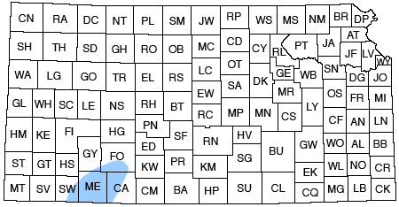
The Meade basin of southwestern Kansas is situated in central and northeastern Meade County and southwestern Ford County. The area here considered includes all of Meade County and adjacent parts of Seward, Ford, and Clark counties, Kansas, and Beaver County, Oklahoma. The location of the area studied is shown in figure 1.
Fig. 1--Map of Kansas showing the location of the area studied.
Attention was first focused upon the geology of the Meade area about a half century ago by Cragin (1891, 1896), Haworth (1896, 1897, 1897a, 1897b), and Johnson (1901, 1902). Cragin made a reconnaissance of the geology of this region, named some of the deposits, and collected vertebrate fossils. Haworth and Johnson studied the stratigraphy, structure, and ground-water resources of the area, and drew attention particularly to that part of the basin in which flowing artesian wells occur. After the work of these men a period of more than 30 years elapsed, during which the geology of southwestern Kansas received little or no attention. The stratigraphic terms proposed by Cragin never came into general use, and, as illustrated by the 1937 geologic map of Kansas (Moore and Landes, 1937), the Tertiary and Quaternary deposits of this area were grouped together and assumed to be equivalent to the Ogallala formation of western Nebraska and Kansas.
During the last several years attention has again been drawn to the Meade basin and a considerable quantity of additional data has been obtained. During the last six seasons Hibbard has collected vertebrate fossils from this area, some of which have been described (Hibbard, 1938, 1938a, 1939, 1939a, 1940, 1941, 1941a; Taylor, 1941). Smith (1940) spent the field seasons of 1937, 1938, and 1939 in making a reconnaissance of the geology of southwestern Kansas, including the Meade basin. In July, 1939, a detailed investigation of the geology and ground-water resources of Meade County was undertaken by the United States Geological Survey and the Kansas Geological Survey, in cooperation with the Division of Water Resources of the Kansas State Board of Agriculture and the Division of Sanitation of the Kansas State Board of Health. This work was done by John C. Frye under the supervision of S. W. Lohman, Federal geologist in charge of groundwater investigations in Kansas. A preliminary report on the water supply of the Meade artesian basin has been published (Frye, 1940) and a detailed report is in preparation on the geology and ground-water resources of Meade County, which includes a geologic map of the county.
In 1939 and 1940, 25 test holes were drilled in the county by means of a portable hydraulic-rotary drilling machine owned by the Federal and State Geological Surveys and operated by Ellis Gordon, driller; Perry McNally, sampler; and Laurence Buck, helper. These holes ranged in depth from 30 to 600 feet, and went through the Quaternary and Tertiary deposits into Cretaceous or Permian bedrock. The test drilling provided very valuable data as to the subsurface structure and lithology of these beds, and several test holes yielded snails, which have been studied by Calvin Goodrich of the University of Michigan and Byron Leonard of the University of Kansas,
It is the purpose of this paper to summarize the recently acquired data from the Meade area; to discuss the lithology, age, correlation, and vertebrate faunas of the Tertiary and Quaternary strata and the factors that controlled their deposition; and to propose a classification of these rocks that is consistent with their geologic history and that can be used in the field for mapping purposes. In this paper the physiography and stratigraphy are discussed by Frye and the vertebrate faunas and their ages by Hibbard.
We express thanks to H. T. U. Smith of the University of Kansas, who spent some time in the field with us, offered helpful suggestions and criticisms, and made available a manuscript copy of his report prior to its publication. Byron Leonard of the Department of Zoology, University of Kansas, who has collected snails from many localities in the Meade area and has examined shells found in samples from test holes, has been very helpful in our study. K. E. Lohman, of the U.S. Geological Survey, who previously had studied diatoms from Pliocene and Pleistocene beds of the High Plains, examined material from the Laverne formation in Seward County, and Willis L. Tressler of the University of Maryland examined ostracodes from the same locality, for which sincere appreciation is expressed. Thanks are extended to the various members of the Federal and State Geological Surveys who have offered suggestions and read and criticized the manuscript.
Meade County is situated in the western part of the Plains Border section and the eastern part of the High Plains section of the Great Plains physiographic province (Fenneman, 1922, pl. 1). From the western part of the county westward into Colorado, the High Plains extend as a gradually rising and relatively unbroken flat surface. Haworth (1897) and Johnson (1901) were in agreement that this surface is underlain by fluvial deposits laid down by streams that flowed eastward from the Rocky Mountain region during Late Tertiary time. During Early Tertiary time this part of Kansas was subject to subaerial erosion, while sediments were accumulating in other parts of the High Plains region.
The earliest known Tertiary sedimentation in this area occurred during early Pliocene time in southwestern Meade County and southeastern Seward County, Kansas, and Beaver County, Oklahoma. These deposits have been named the Laverne formation by V. V. Waite (unpublished manuscript quoted by C. N. Gould and J. T. Lonsdale, 1926, p. 33). They were in part probably deposited in small lakes (Gould and Lonsdale, 1926, p. 33) and in part on the flood plains of streams. Some deformation occurred after their deposition and prior to the deposition of the overlying Ogallala formation. It is not known whether this disturbance was due entirely to deep-seated diastrophism or was partly controlled by solution of underlying Permian rocks followed by resultant differential subsidence of the surface.
After the folding of the Laverne strata, erosion beveled these beds to an irregular surface, upon which, during middle Pliocene time, aggrading and laterally shifting streams deposited the sediments comprising the Ogallala formation. The middle Pliocene part of this formation consists of channel and floodplain deposits that range from moderately well sorted gravel to poorly sorted sandy silt. The deposits were spread over the surface of a large part of the area under consideration, but, owing to the irregularities of the pre-existing topography, the thickness ranges from a feather edge to scores of feet. At the end of middle Pliocene time the upper surface of these deposits constituted a relatively flat nearly featureless plain. On or below this surface was developed a widespread deposit of caliche, which marks the top of the middle Pliocene sediments. Small local ponds may have existed for a time on this surface and may have played some part in the development of this caliche, but, as pointed out by Smith (1940, pp. 90-92) and others, it seems hardly possible that a large lake or lakes could have existed in the High Plains region at that time.
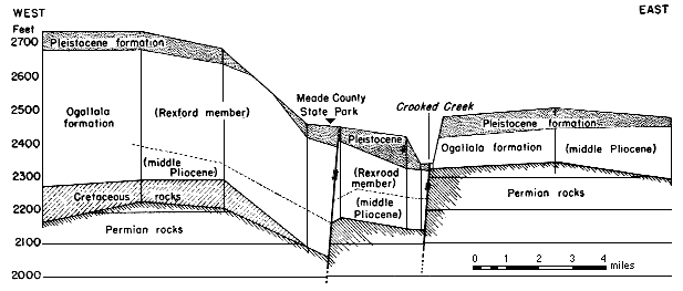
At or immediately after the end of middle Pliocene time the major faulting of the Meade basin began. The most important fault occurred along a south-southwest line approximately in the position of the present course of Crooked Creek valley south of Meade, and extended from a point north of Meade to the Oklahoma state line. Less important parallel faults occurred east and west of the Crooked Creek fault. The total displacement of the faults and the faulting of the Pliocene and Pleistocene beds south of Meade are shown in figure 2. It is not known whether this faulting was due to deep-seated diastrophism or was controlled wholly or partly by solution of the underlying Permian salt and gypsum beds. It seems certain, however, that subsequent to the faulting, solution and subsidence played an important role in deepening the structural depressions and developing many sink holes of various sizes east of the faults.
Fig. 2--Schematic east-west cross-section through Meade County State Park, south of Meade. Test holes are indicated by vertical lines.
The sediments that constitute the Rexroad member of the Ogallala formation were trapped in these major depressions during late Pliocene time. The location of the master streams in the Meade area at the end of middle Pliocene time and during late Pliocene time is not known. It seems probable, however, that during at least part of this epoch some sediment from the Rocky Mountain region was carried into this basin, in addition to material eroded from the adjacent older Tertiary deposits that were exposed west and northwest of the Meade basin. Most of the beds were deposited by streams, but some beds may have been laid down in ponds, and the presence of peat implies the existence of small swamps or bogs during part of this time. The local basin in which the Rexroad member was deposited extends westward from the Crooked Creek fault into Seward County, and may extend northwestward into Haskell and Gray counties. It should be regarded, however, as a more or less isolated basin, which, owing to the local structural conditions, trapped a relatively thick sequence of deposits at a time when most of the Great Plains region was being eroded.
During the late Pliocene, sink holes started to develop on the east or upthrown side of the major faults. A few of these sinks may have been of sufficient size to entrap small quantities of sediment, but the main development of sink holes occurred during the ensuing Pleistocene epoch. It is certain that extensive sink-hole development did not start until late Pliocene time, because at many places middle Pliocene deposits are exposed along the sides of the sinks and extend across them with no apparent thickening. It seems probable that the sinks were produced by deep-seated solution of beds of salt or gypsum in the Permian redbeds, which are known to underlie the middle Pliocene beds at many localities. Owing to the fact that the shallowest known soluble beds of appreciable thickness in the Permian are now several hundred feet below the water table, a special type of deep-seated circulation of ground water must be postulated to account for this sink-hole development. It is possible that the faulting opened passageways in the Permian rocks and permitted ground-water circulation.
Renewed movement along the major faults during very late Pliocene or early Pleistocene time locally changed stream gradients and deepened the structural-solutional basin, which previously had been nearly filled with deposits, and this movement allowed sedimentation to be resumed. It is possible that at some localities in the basin a continuous sequence of deposits was laid down, uninterrupted by any break between the Pliocene and the Pleistocene. At many places, however, the basal Pleistocene sands and gravels were deposited on a surface that had been eroded somewhat. Because these basal Pleistocene gravels are coarser than adjacent deposits of Pliocene age--except the basal Ogallala gravel, which was not extensively exposed to erosion at this time--and because they contain a much larger percentage of igneous rock pebbles, it seems probable that a stream flowing from the Rocky Mountain region carried some sediment into this area during the early Pleistocene. Pebbles that seem to have been eroded from the Pliocene strata west of the Meade area also occur in these deposits, hence probably there was a mixing of material from several sources.
The early Pleistocene deposits completely filled the major basin and spread across the adjacent area to the east of the Crooked Creek fault. Simultaneously deposits of local origin were accuinulating in some of the large sinks east of the Meade basin.
After early Pleistocene sedimentation, which completely filled the major basin, there was a time during which only a small amount of erosion and deposition occurred. Streams flowing across the depositional surface were competent mostly to transport their loads through the area, neither eroding nor depositing. Locally, however, some deposits were trapped in abandoned channels and sink holes. These deposits constitute the upper channel phase of the Meade formation.
During the late Pleistocene, streams flowing at the upland level again began aggrading their channels and flood plains, and laid down the fine sand and silt that constitutes the lower part of the Kingsdown silt. These deposits cover much of the upland surface, indicating that streams must have shifted laterally at frequent intervals. Inasmuch as these fluvial deposits grade upward into loess, stream deposition probably was accompanied by and followed by eolian activity. The deposition of this thin fine-grained, widespread upland formation marks the last recorded episode, of the Pleistocene epoch. The upper, eolian part of the Kingsdown silt may have been deposited in the Recent epoch after the major streams had started the down-cutting that has produced the present topography.
The latest movement along the Crooked Creek fault occurred in the Recent epoch, displacing the Pleistocene formations and again giving surface expression to the basin. Sink-hole development has continued into Recent time, as attested by the formation of the "Meade salt sink" within historic time (Johnson, 1901, pp. 706-707). Erosion has been the dominant process during the Recent epoch, however, in the development of the present drainage pattern. The erosion of the Cimarron valley in its present position seems to have occurred chiefly since Pleistocene time, as is indicated by the presence, along the valley, of terrace gravels that lie unconformably on middle or upper Pleistocene deposits nearly at the level of the High Plains. Crooked Creek occupies a series of dissected sinks from the point where it crosses the major fault to Cimarron River, and probably took its present course during late Pleistocene or early Recent time by progressive sink-hole capture. Crooked Creek thus became the outlet for the ponded water in the Meade basin (Frye, 1940, p. 14).
Recent deposits in the Meade basin comprise thin alluvium and low terrace deposits along Cimarron River, Crooked Creek, and Sand Creek, and their tributaries, and natural levees along part of Crooked Creek and its tributaries. Eolian sand occurs at many places on the upland surface and along the valley flat of Cimarron River.
A summary of the Pliocene and Pleistocene stratigraphy of this area is given in the following table, which includes also the named local faunas, faunal zones, and provincial ages of the faunas. The rest of this paper is devoted to a discussion of the lithology, age, and fossil content of these formations.
| Generalized section of Tertiary and Quaternary Formations in the Meade Basin. Provincial age terms and faunal zones are those proposed by H. E. Wood and others in "Nomenclature and correlation of the North American continental Tertiary" published in Geol. Soc. America Bull., vol. 52, Plate 1, 1941. |
|||||||
| System | Series | Formation | Thickness, feet |
Character | Local Faunas |
Provincial age |
Faunal zone |
|---|---|---|---|---|---|---|---|
| Quaternary | Recent and Pleistocene |
Dune sand Unconformable on |
0-50 | Eolian sand, well sorted, medium- to fine-grained, locally contains some silt and grades into silt. Buff to brick red. | |||
| older formations Alluvium and terrace deposits Unconformable on |
0-80 | Gravel, sand, silt and clay; some peaty zones in the "Englewood terrace beds," and some very coarse gravel in the Cimarron valley terrace. | Bison bison; deer, and domesticated animals, and snail faunas. | ||||
| older formations Kingsdown silt Disconformity |
10-45 | Silt and fine sand, containing caliche nodules and bands. Typically thin-bedded sand at base grading upward into loess. Tan to gray-buff. | Bison bison. | ||||
| Pleistocene | Meade formation Disconformity |
50-155 | Gravel, sand, silt, and clay, containing caliche nodules and beds and cemented ones. Volcanic ash and gypsum zones in lower part. A local unconformity occurs in upper part. Red, pink, tan, and gray. | Jones fauna, Cragin quarry fauna, Borchers fauna, and snail faunas. | Equus | ||
| Tertiary | Pliocene (Upper and middle) |
Ogallala formation Rexroad member Local disconformity |
50-250 | Sand, silt, and clay, containing caliche nodules and bands, and some cemented zones. Locally peat occurs near the top. Pink, tan, and gray. | Rexroad fauna and snail faunas. |
Blancan | Plesippus |
| Ogallala formation Nonconformity |
10-125 | Gravel, sandy silt, and caliche, basal gravel loose or cemented. Locally a hard, partly silicified caliche (algal limestone?) occurs at top. Pink, tan, and gray. | Biorbia fossilia plant remains |
Hemphillian | Dipoides | ||
| Pliocene (Lower) and Miocene |
Laverne formation | 60+ | Shale, sandstone, and limestone. locally contains a hard conglomerate. Bluff, blue gray, and gray. | Ostracode fauna, and fragmentary plant remains |
Clarendonian | Eucastor | |
Laverne Formation
The Laverne formation was named from exposures in Harper and Beaver counties, Oklahoma, and described by V. V. Waite in an unpublished manuscript, quoted by Gould and Lonsdale (1926).
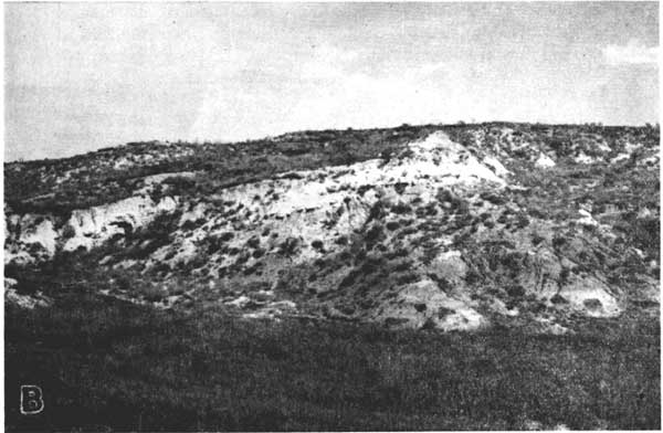
The early literature dealing with this formation has been summarized by Hesse (Chaney and Elias, 1936, pp. 47-51). In Kansas, the Laverne is well exposed along both sides of the Cimarron valley in southeastern Seward County (Smith, 1940, pp. 37-39), and in southwestern Meade County.
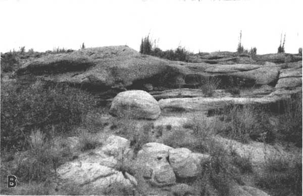
Character--A generalized section of the Laverne formation in Kansas is given in figure 3A. These beds generally are well indurated and are more resistant to erosion than the overlying deposits. The formation consists of gray fine-grained thin-bedded sandstone, some of which contains conglomerate as shown in plate 1A; blue-gray to tan even-bedded shale; and tan soft silty limestone, which typically includes a thin bed of gray dense limestone at the top. The soft silty limestone can be cut with a saw and has been quarried for building stone and used in the construction of ranch buildings in the Cimarron valley. We regard the Laverne as a distinct formation rather than a member or zone of Ogallala formation, as suggested by Hesse (Chaney and Elias, 1936, p. 51), because: (1) the nonconformity that separates the Laverne from the Ogallala is the greatest break in sedimentation recorded in the Pliocene and Pleistocene section. The beds of the Laverne dip at angles as great as 15 degrees and are overlain by horizontal beds of the Ogallala; (2) the lithology of the Laverne is distinct from that of the overlying Ogallala--in fact, on casual inspection these beds more closely resemble the underlying Cretaceous rocks than they do the Ogallala; and (3) it is a unit that is easily recognizable and mappable in the field.
Fig. 3A--Generalized section of the Laverne formation in Meade and Seward counties.
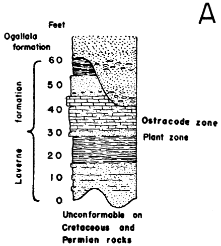
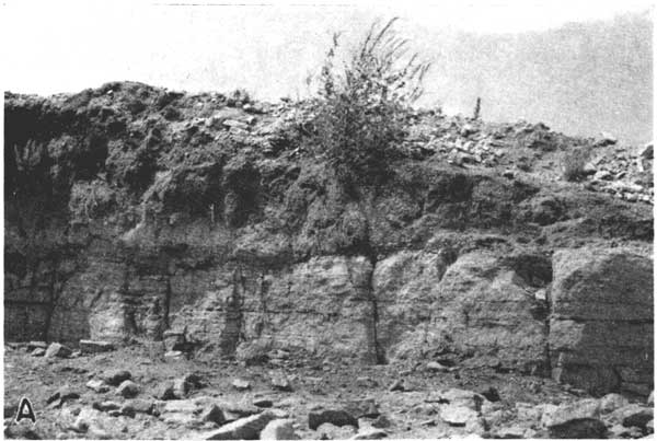
Plate 1A--Cemented Pliocene sand and gravel. Conglomerate in the Laverne formation on the south side of the Cimarron valley, southeastern Seward County, Kansas.
Age and fossils--In the summer of 1938 Mr. and Mrs. Neil reported that many years ago a complete fish, a turtle, and leaves were found in a building-stone quarry in the Laverne forrnation on the Neil ranch in sec. 24, T. 31 E., R. 34 W., but all the specimens thus reported hane been lost. In 1938 a zone containing isolated fish scales was located just west of the quarry on the Neil ranch, but no identifiable specimens have yet been found. A few fragmentarv bones were found in an exposure on the south side of the river. Ostracodes and diatoms have been found in the soft limestone beds exposed on the north side of the river in westernmost Seward County.
In 1931 Hibbard and McNown collected vertebrate fossils from clay beds in the Laverne beds of Beaver County, Oklahoma, and these fossils have been described by Stirton (1935, pp. 437-438) and Hesse (Chaney and Elias, 1936, pp. 56-68). In the summer of 1940, in company with S. L. Schoff of the U.S. Geological Survey, we visited several exposures of the Laverne formation in Beaver County, Oklahoma, including those from which the fossil vertebrates and plants had been collected in 1931. On the basis of lithology and stratgraphic position it seems certain that the beds in southwestern Meade County and southeastern Seward County are equivalent to the fossiliferous deposits in Beaver County.
Ostracodes collected from the soft silty limestone, below the diatom zone of the Laverne formation on the Neil ranch, southwestern Seward County, were sent to Willis L. Tressler of the University of Maryland for identification. Tressler made the following comments on the ostracodes (Personal communication, dated May 7, 1941):
The most numerous species is Cyprideis littoralis (Brady) with both males and females present in large numbers. . . . This form is a species which occurs at the present time in brackish lakes particularly along the margins. Its distribution includes Norway, British Isles, the Baltic, Sea of Azow, Asia, and Africa and it has been found as a fossil in Sweden and Scotland. . . .
The other species, which is fairly abundant, is Candona crogmaniana Turner, which may be told by the highly arched dorsal margin and indented ventral margin. I found a number of females and only one male. . . . It is a form which originally was described from small pools in Georgia but which has since then been found in a wide variety of habitats; I have myself found it at the bottom of Lake Mendota in the oxygenless waters in the St. Lawrence, and widely distributed in New York; and Furtos reports it as common in Ohio. It is evidently an almost ubiquitous species.
During the fall of 1940 S. W. Lohman collected material containing diatoms from above the Ostracode zone in the soft, silty limestone of the Laverne formation on the Neil ranch, southeastern Seward County. This material has been studied by K. E. Lohman of the U.S. Geological Survey, who found 34 species and varieties of diatoms, listed and discussed as follows (Personal communication dated April 1, 1941.):
| Diatoms from the Laverne formation of southeastern Seward County, Kansas (U.S.G.S. diatom Locality 3010). |
|
| Achitanthes coarctata Brébisson | Rare |
| Amphora cf. a. exigua Gregory | Rare |
| Amphora ovalis Kutzing | Frequent |
| Amphora coffaeiformis var. fossilis (Pantoesek) Cleve | Rare |
| Amphora n.s.p. | Common- Abundant |
| Anomoeoneis sphaerophora (Kützing) Pfitzer | Frequent |
| Bacillaria paradoxa Gmelin | Common |
| Cymbella mexicana (Ehrenberg) Cleve | Rare |
| Denticula sp. | Rare |
| Diploneis ovalis Hilse | Frequent |
| Diploneis ovalis var. oblongella (Naegeli) Cleve | Frequent |
| Diploneis smithii (Brebisson) Cleve | Frequent |
| Epithemia hyndmanni Wm. Smith | Rare |
| Fragilaria harrissonii var. dubia Grunow | Rare |
| Frustulia rhomboides (Ehrenberg) De Toni | Abundant |
| Gomphonema sp. | Rare |
| Mastogloia elliptica Agardh | Rare |
| Mastogloia n.s.p. | Common |
| Melosira cf. m. islandica Müller | Rare |
| Melosira italica (Ehrenberg) Kützing | Rare |
| Melosira cf. solida Eulenstein | Rare |
| Navicula cf. n. incerta Hustedt | Rare |
| Navicula mutica Kützing | Rare |
| Navicula radiosa Kützing | Rare |
| Navicula sp. | Rare |
| Nitzschia cf. n. vitrea Norman | Rare- Frequent |
| Nitzschia cf. commutata Grunow | Rare |
| Nitzschia sp. | Common |
| Pinnularia borealis Ehrenberg | Frequent |
| Pinnularia cf. major (Kützing) Cleve | Rare |
| Pinnularia cf. microstauron (Ehrenberg) Cleve | Rare |
| Pinnularia viridis (Nitzsch) Ehrenberg | Rare |
| Rhopalodia gibba (Ehrenberg) Müller | Rare |
| Rhopalodia gibberula (Ehrenberg) Müller | Rare |
| Stauroneis cf. s. phoenicenteron Ehrenberg | Rare |
| Surirella cf. s. striatula Turpin | Rare |
This diatom flora contains a large number of species that live in saline lake waters at the present time and their occurrence in the beds in Seward County suggests very strongly that they were deposited under similar conditions. This suggestion is strengthened by the fact that many of the diatoms in this material are misshapen individuals characteristic of diatoms growing in water that contains considerable alkali.
With the data at hand the best determination of age of this flora that can be made is from upper Miocene to lower Pleistocene, inclusive. The uncertainty is caused by the following factors: (1) the geologic ranges of some of the species are not known with enough certainty; (2) two of the most abundant diatoms present are new species and hence yield virtually no stratigraphic information; (3) there appears to be a curious mixing of species that go back as far as upper Miocene with some that are not known from rocks older than Pleistocene; and (4) the highly saline character of the water in which these diatoms grew indicates that they constitute a saline facies flora which may be and probably is quite different from a normal fresh water flora of the same age.
This flora cannot be correlated with the diatom-bearing beds in Beaver County, Oklahoma (Chaney and Elias, 1936, pp. 14, 15, 23) as only 12 percent of the present flora occurs in the Beaver County material. Eighteen percent of the present flora occurs in the Ogallala formation of Wallace County, Kansas (Hanna, 1932), but this again is too small a percentage for a comparison, particularly as it does not include the most significant species.
Although the exposures in Kansas have not as yet yielded identifiable vertebrate fossils it is possible that in the future more intensive searching may reveal fossils in the same clay-shale beds from which fossils have been taken in Oklahoma. The position of the Laverne formation unconformably below middle Pliocene deposits, and the presence of lower Pliocene fossils in the upper part of the formation, date it as lower Pliocene, and the lower part possibly is upper Miocene in age.
Ogallala Formation
Middle Pliocene Beds
There has been a tendency on the part of some geologists who have carried on field studies in western Kansas to use the Ogallala formation as a widely inclusive term, grouping together under this classification all the beds that occur above the bedrock floor and below the surface of the High Plains, excluding only deposits such as dune sand and alluvium. The term Ogallala formation was first proposed by Darton in 18991, presumably from a locality, which he later designated, near Ogallala Station, Keith County, Nebraska. Smith, in 1940, (pp. 39-94) summarized the previous literature dealing with this formation in the High Plains regions, and restricted its upward extension to the top of the middle Pliocene, but we classify upper Pliocene deposits also as belonging to the Ogallala formation. The description of the Ogallala formation and its subdivisions given below pertains to the Meade basin and vicinity, and no attempt will be made to indicate correlations with the several units that are classed as formations belonging to the Ogallala group in Nebraska.
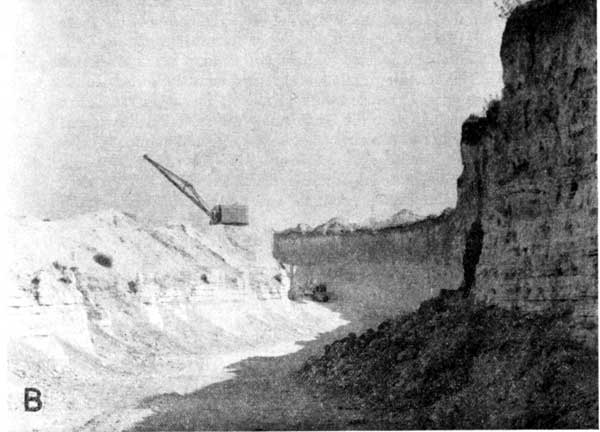
Character and subdivisions--A generalized section showing the lithology of the Ogallala formation in Meade County is given in figure 3B. Locally the basal part of the formation consists of thick beds of sand and gravel, which may or may not be tightly cemented with calcium carbonate. A view of the cemented, or "mortar bed", type of rock is shown in plate 1B. The texture of these crossbedded channel deposits ranges within wide limits. In this area it is possible to recognize the basal Ogallala sand and gravel even in isolated exposures on the basis of lithology alone, because it contains the only gravel and in most places the only well-sorted material in the Ogallala formation. Beds of similar texture occur in the overlying Meade formation, but these can be distinguished by the fact that they contain a distinctly different assemblage of rock types. The basal Ogallala gravel contains abundant pebbles of sandstone, and concretions that seemingly were derived from the Dakota sandstone, and also contains pebbles and cobbles of limestone, red shale, and siltstone, and blocks of silicified wood. All these rock types occur in the Pleistocene gravels, but are much less abundant. Granite pebbles are rare in the basal gravel of the Ogallala, whereas pebbles of pink granite and pegmatite are abundant in the Meade. Pebbles of black, scoriaceous basalt occur more abundantly in the Pleistocene deposits than in the Ogallala. Abraded pebbles of caliche and "mortar bed", common in the Pleistocene gravels, have never been noted by us in the basal gravels of the Ogallala. In this area the induration of the deposit is not a valid criterion as to its age, inasmuch as both loosely and tightly cemented beds occur at various horizons from the basal gravel of the Ogallala upward through the Meade formation. It seems probable that in some localities Smith (1940, pp. 42-43) has confused the basal gravel of the Meade with the basal gravel of the Ogallala and thus may have regarded these two gravels as two phases of the Ogallala.
Fig. 3B--Generalized section of the Ogallala formation in Meade County. The positions of the "algal limestone" horizon, a zone of abundant Biorbia fossilia, the Rexroad fauna, and several snail zones are shown. This is a composite section, and it should be noted that in those localities in which the middle Pliocene part is well exposed the Rexroad member typically is thin or absent.
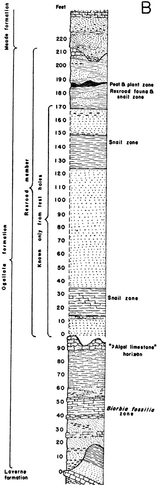
Plate 1B--Cemented Pliocene sand and gravel. Cross-bedded and cemented sandstone, or mortar bed, in the lower part of the Ogallala formation, near the Kansas-Oklahoma state line in Southwestern Meade County, Kansas.
The middle Pliocene deposits above the basal gravel consists dominantly of sand, silt, and caliche, and locally at the top a hard bed of caliche or limestone. Some beds are structureless, but others are cross-bedded. The caliche occurs as cementing material, pipey concretions, irregular beds, or nodular bands. The lithology of this part of the Ogallala possesses very few distinctive features and is nearly duplicated both in the Rexroad member and in the Meade formation. Bedded clay has not been observed in this sequence, and fossils are rare. The caliche or limestone bed that marks the top of the middle Pliocene part of the Ogallala, however, locally has a very distinctive lithology. In northwestern Kansas it was called the "Algal limestone" by Elias (1931, pp. 136-141), and in this area, where it contains no recognizable algal structures, it was described by Smith (1940, pp. 44-46) as the "capping limestone". This bed is locally nearly 6 feet thick, is verv hard locally, and in eastern Meade County and western Clark County it contains considerable chert.
Age and fossils--An upper molar of Amebelodon fricki Barbour is the only vertebrate fossil that has been found in the middle Pliocene deposits of Meade County. It was taken from consolidated sandstone south of the gravel pit on the Borchers ranch in sec. 28, T. 33 S., R. 28 W. In the summer of 1937 abundant seeds of Biorbia fossilia, which were identified by M. K. Elias (Personal communication dated Feb. 8, 1938) were taken from an upper "mortar bed" at the gravel quarry described above and also from a slightly lower bed just northeast of the pit in section 16.
Beds in Clark County that occur at the same stratigraphic position have yielded some of the same middle Pliocene mammals (Hesse, 1935) as those taken from "Edson" quarry (Hibbard, 1939b), Sherman County, and "Rhino Hill" quarry, Wallace County, Kansas. This fragmentary fossil evidence, together with the stratigraphic position of these beds above the lower Pliocene Laverne formation and below the upper Pliocene Rexroad member, definitely date the lower part of the Ogallala formation as middle Pliocene in age.
Rexroad Member
In 1940 the upper Pliocene beds of central Meade County were named the Rexroad formation by Smith (1940, p. 95), from exposures along a tributary to Crooked Creek on the Rexroad ranch, in the same general locality from which the Rexroad fauna was collected by Hibbard (1938). The choice of this type locality was somewhat unfortunate, as only the uppermost part of the formation is here exposed. The top of the formation, moreover, was not defined by Smith, although it is exposed in this area; and beds of Pleistocene sand and gravel, which here unconformably overlie the Pliocene beds, were not clearly excluded from the Rexroad.
In the classification proposed in this paper the beds called the Rexroad formation by Smith are designated as the Rexroad member (upper Pliocene) of the Ogallala formation. This is deemed advisable for the following reasons: (1) As stated above, on the basis of both surface and subsurface data, it seems evident that in parts of the basin there was continuous sedimentation from middle Pliocene through upper Pliocene time, and in these localities no break is distinguishable; (2) the deposits were trapped in a local basin, and, although there are deposits of equivalent age outside this general area, they are not stratigraphically continuous with the deposits of the Rexroad type locality, and are not genetically related to them; and (3), as Smith (1940, pp. 95-97) has pointed out, the lithology of the Rexroad beds for the most part is indistinguishable from the middle Pliocene part of the Ogallala formation. For these reasons the Rexroad beds do not constitute a mappable unit, except partially in the vicinity of the type locality, where the upper contact, but not the lower, can be mapped.
Character--The lower and thicker part of the Rexroad member does not crop out at the surface in the Meade basin area, so that the thickness and character of the member are known only from test-hole samples and well logs. Where the entire member is present it is about 200 feet thick, but in the deepest part of the basin it may attain a maximum thickness of 250 feet, and east of the Crooked Creek fault it is only about 30 feet thick. On the basis of data from test holes, the lower 175 feet of the Rexroad member may be described as comprising alternating beds of sand, silt and clay. The thickness of individual beds ranges considerably. Two well-defined snail zones were encountered in the test drilling, and these fossils, some of which were brought to the surface unbroken, have aided in the recognition of these beds.
The upper beds of the Rexroad member, which are exposed at the surface, consist of blue-gray, tan, and gray sand, silt and clay. At many places a bed of soft sandy caliche occurs at the top of the member and at a few localities a thin bed of peat occurs 20 to 30 feet below the top. The Rexroad member of the Ogallala formation is overlain unconformably by the basal sand or gravel of the Meade formation of Pleistocene age. A generalized section of the Rexroad member in central Meade County is shown in figure 3B.
Age and fossils--Some fossils, notably snails, have been recovered from test holes penetrating the lower part of the member, but no vertebrates have been obtained from beds more than 50 feet below the top.
The age and correlation of this member are based primarily upon fossils constituting the Rexroad fauna, which were taken from the upper 50 feet. This fauna consists of associated mollusk, fish, amphibian, reptile, bird, and mammal remains.
The following mollusks have been identified by Baker (1938), and a complete study of the fauna is planned for future publication.
| Mollusks of the Rexroad fauna | |
|---|---|
| Freshwater forms Pisidium sp. Stagnicola reflexa (Say) Physa anatina Lea Ferissia rivularis (Say) Ferrissia parallela (Haldeman) Menetus kansasensis F. C. Baker |
Land snails Carychium perexiguum F. C. Baker Polygyra mooreana tholus (Binney) Retinella electrina (Gould) Retinella rhoadsi Pilsbry Retinella wheatleyi Bland Hawaii miniscula Binney Helicodiscus singleyanus Pilsbry Gastrocopta tappaniana C. B. Adams Gastrocopta holzingeri (Sterki) Gastrocopta cristata Pilsbry and Vanatta Vertigo hibbardi F. C. Baker Vertigo milium Gould Pupoides marginatus (Say) Pupoides inornatus Vanatta Strobilops sparsicostata F. C. Baker Vallonia gracilicosta Reinhardt Succinea grosvenori Lea Succinea grosvenori gelida F. C. Baker |
The lizards of the Rexroad reported by Taylor (1941) are as follows:
| Lizards of the Rexroad fauna | |
|---|---|
| Cnemidophorus bilobatus Taylor Eumeces striatulatus Taylor |
Eumecoides hibbardi Taylor Eumecoides mylocoelus Taylor |
Excepting the lizards, the fish, amphibian, reptile, and bird remains have not been studied. Following is a list of the known mammals of the Rexroad fauna, as reported by Hibbard (1938, 1939,1941,1941a).
| Mammals of the Rexroad fauna | ||
|---|---|---|
| Insectivora Sorex taylori Hibbard Blarina? sp. Hesperoscalops rexroadi Hibbard Scalopus sp. Chiroptera genus? Carnivora Canis lepophagus Johnston Canis large sp. Procyon rexroadensis Hibbard Brachyprotoma breviramus Hibbard Spilogale rexroadi Hibbard Taxidea taxus (Schreber) Trigonicitis kansasensis Hibbard Machairodus sp. Felis sp. Felis lacustris Gazin |
Rodentia Citellus howelli Hibbard Citellus rexroadensis Hibbard Eutamias or Tamias sp. Geomys sp. Liomys centralis Hibbard Perognathus gidleyi Hibbard Procastoroides lanei (Hibbard) Onychomys sp. Baiomys rexroadi Hibbard Peromyscus kansasensis Hibbard Eligmodontia? arizonae Gidley Symmetrodontomys simplicidens Hibbard Sigmodon intermedius Hibbard Parahodomys quadriplicatus Hibbard *Pliolemmus antiquus Hibbard *Phenacomys primaevus Hibbard Ogmodontomys poaphagus Hibbard *Pliopotamys meadensis Hibbard |
Lagomorpha Pratilepus kansasensis Hibbard Dicea lepitscula Hibbard Nekrolagus progressus (Hibbard) Hypolagus regalis Hibbard Proboscidea Mastodont Perissodactyla Plesippus simplicidens (Cope) Nannippus phlegon (Hay) Artiodactyla Platygonus sp. Camelid, small Camelid, large Cervid Capromeryx? sp. |
|
*These fossils were not recovered in place from the upper Pliocene deposit
but from diggings at a C.C.C. camp that penetrated both the basal sand and gravel of the Meade formation and upper Pliocene clay (KUMVP Loc. no. 1). There is some evidence that they are not a part of the Rexroad fauna but belong to a younger Pleistocene fauna. Confirmation of this interpretation must await additional field study. |
||
Vertebrate remains have been found at only three exposures of the Rexroad member. The three localities are situated along a north-south line and all are within a distance of three-fourths of a mile. They are situated along three side branches of a tributary of Crooked Creek and are separated by narrow divides covered with Pleistocene and Recent deposits. The fossils were taken from beds of clay, sandy silt, lenses of fine sand within the silt, and from beds of bog material. No fossils have been found in place in the thick cross-bedded channel sands.
On the basis of the fossil mammals the Rexroad, Blanco, Benson, and Hagerman faunas are believed to be of approximately the same age. The differences between the faunas are thought to be of only geographical sienificance. The Rexroad fauna shows a closer relationship to the Blanco and Benson faunas than to the Hagerman fauna. Although the fauna as a whole shows relationships with forms now found in Mexico and Central America rather than with the Recent forms now found in southwestern Kansas, a few fossil forms possess boreal affinities.
The fauna indicates that meadow flats and timbered areas existed at least along parts of the late Pliocene stream valleys, and that the climatic conditions then were not drier nor colder than those at present. There is some indication, moreover, that the climate of late Pliocene time lacked extremely cold winters or severely hot summers, accordingly being more equable than the present climate, and that there was a somewhat greater degree of humidity than exists now in this region.
The Pleistocene fluvial deposits of southwestern Kansas formerly have been included with the Pliocene deposits and referred to the Ogallala formation. Cragin described briefly and named some of the beds now known to be of Pleistocene age and referred them to the upper Pliocene, but his names never came into general use. In 1940 Smith (pp. 99-129) pointed out that in southwestern Kansas, particularly in the vicinity of the Meade basin, there is a thick sequence of Quaternary deposits. At that time he named several new units, discarded or redefined some of Cragin's earlier names, and left part of the Pleistocene section unnamed. Excepting the Kingsdown silt, the units named by Smith and by Cragin have proved to be unsatisfactory for field mapping. It is here proposed to revive Cragin's term "Meade gravels" (1896, p. 54), and redefine it as the Meade formation, to include all the beds of Pleistocene age between the top of the Rexroad member of the Ogallala formation and the base of the Kingsdown silt. Cragin's Kingsdown formation of late Pleistocene age is regarded as a valid stratigraphic division but it is redefined to include the overlying loess because, as Smith (1940, p. 113) states, the water-laid deposits locally grade upward into the loess and can be distinguished from the loess only by their bedding. The terrace deposits, alluvium, and dune sand of late Pleistocene and Recent age are described briefly but no stratigraphic names are applied to them.
Meade Formation
In 1896 Cragin (p. 54) named the "Meade gravels" from Meade Center, Meade County, Kansas. These gravels were described as underlying the "Pearlette ash" and as containing vertebrate fossils. As here redefined the Meade formation includes the "Meade gravels" of Cragin at the base; Cragin's "Pearlette ash"; Smith's "Odee formation," "Equus niobrarensis beds", and "Jones Ranch beds"; and all other beds of Pleistocene age above the Rexroad member of the Ogallala formation and below the Kingsdown silt. Owing to the fact that the original Meade type locality cannot be located accurately, the type locality of the Meade formation is here designated as the exposures along Crooked Creek valley, in Meade Center township, south of the city of Meade, and particularly the Pleistocene beds exposed in sec. 21, T. 33 S., R. 28 W.
Character and subdivisions--A generalized section of the Meade formation, showing the lithology, stratigraphic position of the previously named units, and local faunas, is given in figure 3C. Sand and gravel channel deposits occur at the base of the formation in most places, and locally are thick and coarse-grained. These beds grade laterally into finer sands and in some localities are absent. The sand and gravel may be unconsolidated or, as shown in plate 2A, tightly cemented by calcium carbonate. The contrast between the rock types represented in this gravel and in the older gravel of the Ogallala formation is discussed above. This material is well exposed in two gravel pits in sec. 33, T. 32 S., R. 29 W. This basal sand and gravel grades upward into sand, silt, and caliche that is tan, buff, and pink. Locally some beds are indurated and produce benches on the slopes. In most places a bed of caliche occurs at the top of this zone.
Fig. 3C--Generalized section of the Meade and Kingsdown formations in Meade County. The stratigraphic positions of previously named beds, local vertebrate faunas, and snail zones are shown.
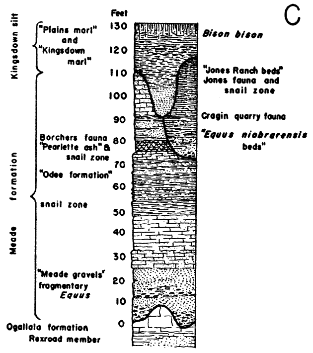
Plate 2A--The Meade formation in central Meade County. Cemented cross-bedded sand and fine gravel of the basal Meade formation (Pleistocene), sec. 3, T. 33 S., R. 29 W.
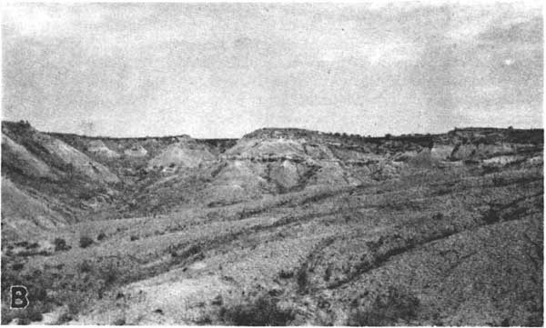
Above the caliche occur beds of clay, silt, and sand that are thin-bedded and interbedded and range from gray, blue-gray, and tan to dark brick red. The thickness of this zone ranges between wide limits and is best developed and best exposed in the southern part of Meade County. These beds are well exposed along the north side of Cimarron valley, south of Meade, as shown in plate 2B. At some localities in northern Meade and central Seward counties the overlying "Pearlette ash" rests directly on the basal sand and gravel. It is within this varicolored zone that Smith's "Odee formation" occurs (Smith, 1940, pp. 100-108). The "Odee formation" has not proved to be a satisfactory unit for field mapping for the following reasons: (1) the formation, as described, has no definite top or bottom; (2) it is essentially a color zone that interfingers with and grades laterally into equivalent beds of different color; and (3) beds of similar appearance at a somewhat different stratigraphic position within the Pleistocene seemingly were trapped in isolated sink holes and some of these beds cannot be distincuished lithologically from the "Odee" at the type locality. At many places where the beds in this zone are well developed they are typified by their red color, loose fine-grained texture, and content of large selenite crystals. The selenite crystals occur at several localities and in some places weather out to form a rubble on the slopes. These are the only deposits within the Quaternary (or Tertiary) of western Kansas known to us that are typified by large and abundant crystals of selenite. At several localities a blue-gray clay containing gastropods and ostracodes occurs interbedded with or at the base of the brick-red material. Along the east side of Crooked Creek the "Odee beds" are overlain by volcanic ash of variable thickness, and along the south side of the Cimarron valley a bed of volcanic ash is included within this zone.
Plate 2B--The Meade formation in central Meade County. Dissected red and tan silt and fine sand beds of the Meade formation, along the north side of the Cimarron valley, Meade County, Kansas. These beds are included within Smith's Odee formation.
In 1896 Cragin (pp. 53-54) assigned to the volcanic ash here included in the Meade formation, the name "Pearlette ash", from Pearlette post office, Meade County. Haworth (1897b) pointed out, however, that it was not desirable to assign a stratigraphic name to such discontinuous lenses that were not as yet proved to be equivalent in age, and the name has not been generally used. This ash bed, from which the Borchers fauna (Hibbard, 1941b) has been taken, is nearly continuous along the east side of Crooked Creek for about 8 miles south of Meade (plate 3B) and is exposed at several localities along the west side of Crooked Creek valley north of Meade and near Fowler. In most places a zone of aquatic snails occurs in the clay and silt at the base of the ash and has been helpful in establishing the contemporaneity of the deposits exposed at different places. Silt, sand, and caliche overlie the ash, and a bed of nodular, hard, caliche occurs in most places at the top of the lower part of the Meade formation.
Plate 3B--Volcanic ash of the Meade formation. Ash pit in volcanic ash of the Meade formation in the NW sec. 35, T. 32 S., R. 28 W. This bed was referred to by Cragin as the Pearlette ash.
Unconformably overlying the Pleistocene beds described above, and here included as the upper part of the Meade formation, is a discontinuous series of channel deposits and associated and isolated sink-hole fillings. These deposits comprise beds of sand, gravel, silt, clay, and caliche. In some places the gravels consist dominantly of abraded pebbles of caliche. Owing to the isolated nature of some of the minor basins in which these deposits accumulated, the beds are not persistent stratigraphically nor similar lithologically, and in many places can be recognized with certainty only by their position above the more widespread deposits of the lower part of the Meade formation and below the Kingsdown silt, and by the abundant content of vertebrate fossils. The Cragin quarry fauna and associated local faunas have been collected from these deposits.
Smith (1940, pp. 108-110) has applied the name "Equus niobrarensis beds" to certain deposits within the Meade formation, some of which have yielded abundant Equus remains. Of the four localities that he described, localities 2, 3, and 4 have proved to be of approximately equivalent age and to belong in the upper part of the Meade formation. The beds at his locality 1, however, which are lithologically quite distinct from those at the other three localities, have been traced into more prolific fossil zones at other localities and found to be correlative with the basal sand and gravel of the Meade formation.
The "Jones Ranch beds" (Smith, 1940, pp. 110-111), which have yielded the Jones fauna, may be equivalent to the upper part of the channel and sink-hole phase described above, but may be more properly referrable to the basal part of the Kingsdown silt. They represent a part of the filling of a large sink hole and so the name is applicable only in a very restricted area. Owing to the fact that sedimentation in this sink hole was continuous during Meade and early Kingsdown time, the beds occurring within it contain no definite erosional break between the Meade and Kingsdown formations, making it difficult to correlate the "Jones Ranch beds" with beds in nearby areas. It is certain that they occur above the "Equus niobrarensis beds", however, and a poorly defined soil zone separates the two deposits. These beds may be referred to the top of the Meade formation, but probably they should be regarded as transitional beds between the Meade and the Kingsdown formations. There is some doubt as to whether or not deposits in such localized areas warrant the application of definite stratigraphic names.
Age and fossils--Only a few fragmentary vertebrate fossils have been found in place in the basal sands and gravels of the Meade formation. Some boreal forms such as Phenacomys primaevus Hibbard, Pliopotamys meadensis Hibbard, and Pliolemmus antiquus Hibbard, that were tentatively included in the list of mammals of the Rexroad fauna, may have come from the basal sands of the Meade instead of from the underlying clays of the Rexroad member of the Ogallala. The fossil locality had been previously worked, and, when the dump was sifted, these forms were found associated with upper Pliocene mammals. These forms have not been recovered in place from the other upper Pliocene deposits as have the rest of the undoubted upper Pliocene forms of the Rexroad fauna. If it is established with certainty that these boreal forms came from the basal sands and gravels of the Meade formation, it may indicate that these deposits were laid down during the time of the earliest glaciation in the Rocky Mountain region. Two fragmentary metapodials of Camelops were found in the consolidated basal gravels and sands of the Meade formation in a quarry in the Meade County State Park. Also, a few fragmentary and isolated Equus teeth have been taken from another quarry in this sand and gravel in Meade County (KUMVP Loc. no. 14).
The Borchers fauna (Hibbard, 1941b) the oldest recognizable Pleistocene fauna in the Meade basin, was taken from the "Pearlette ash" bed of the Meade formation. Many fragmentary bones of small forms have been found on the east side of Crooked Creek (KUMVP Loc. no. 9) near the edge of a lens of ash, which is approximately 4 feet thick. From this locality there have been collected a few limb bones and vertebrae of salamanders, frogs, and toads; snake and lizard vertebrae; bird remains; and remains of small mammals. No fish remains have been found. Following is a list of the Borchers mammalian fauna (Hibbard, 1941b).
| Mammals of the Borchers fauna | |
|---|---|
| Insectivora Sorex taylori Hibbard Carnivora Mustela sp. Spilogale cf. leitcoparia Merriam Lagomorpha Nekrolagus sp. Hypolagus sp. Lepus cf. californicus Gray Artiodactyla Camelops sp. Antilocapridae Genus? |
Rodentia Citellus meadensis Hibbard Citellus cragini Hibbard Geomys sp. Perognathus pearlettensis Hibbard Perognathus gidleyi Hibbard Onychomys fossilis Hibbard Reithrodontomys pratincola Hibbard Sigmodon hilli Hibbard Synaptomys cf. vetus Wilson Zapus burti Hibbard |
The Borchers mammalian fauna is definitely that of an early interglacial stage and represents the oldest known interglacial fauna in Kansas. Several forms show close relationship to, or are identical with upper Pliocene forms, such as Sorex taylori, Perognathus gidleyi, Synaptomys cf. vetus, Nekrotagus sp., and Camelops sp. The abundance of Sigmodon hilli, of which more than 150 fragmentary rami and maxillaries and many isolated teeth, have been recovered, and Onychomys fossilis, indicates a warm temperate climate. At present Sigmodon is not known to occur farther north in the High Plains than Meade County.
No glacial fauna is known to occur between the Borchers fauna and the Cragin quarry fauna. The Cragin quarry fauna represents another interglacial fauna higher in the section than the Borchers fauna, in the upper or channel phase of the Meade formation. This fauna has not been studied in as great detail as the Borchers and Jones faunas. The following is a list of the Cragin quarry fauna as reported by Hay (1917, pp. 39-60) and Hibbard (1938a, 1939a).
| Cragin quarry fauna | ||
|---|---|---|
| Reptilia | ||
| Testudo equicontes Hay | ||
| Mammalia | ||
| Edentata | ||
| Paramylodon harlani (Owen) | ||
| Carnivora | ||
| Canis occidentalis Richardson | ||
| Smilodon sp. | ||
| Felis cf. imperialis Leidy | ||
| Felis cf. oregonensis Rafinesque | ||
| Rodentia | ||
| Geomys lutescens (Merriam) | ||
| Perissodactyla | ||
| Equus francisci Hay | ||
| Equus leidyi Hay | ||
| Equus niobrarensis Hay | ||
| Artiodactyla | ||
| Camelops kansanus Leidy | ||
In 1938 an invertebrate fauna was collected by Hibbard from beds near the site of the Cragin quarry, and was reported by Smith in 1940 (p. 109). Late in the summer of 1940 a disconformity was discovered below the channel phase containing the Cragin quarry fauna. As it is not known whether the beds from which this fauna was collected lie above or below this disconformity, the stratigraphic position of the invertebrate fauna is now open to question.
Another exposure of the upper or channel phase of the Meade formation occurs east of the Cudahay volcanic-ash pit, north of Meade. From this locality have been collected Equus niobrarensis Hay, Camelops kansanus Leidy, and Parelephas columbi (Falconer).
Many Equus niobrarensis remains have been taken from sinkhole deposits in the upper part of the Meade formation in the Jones sink southeast of Meade. On the basis of these fossils and fossils from the overlying deposits, which have yielded mammals of the same age as the Jones fauna, such as Cynomys ludovicianus Ord and Microtus pennsylvanicus (Ord), the deposits in the Jones sink seem to be of approximately the same age as the channel phase that contains the Cragin quarry fauna. The fauna contains no boreal forms and must be regarded as having lived during a later interglacial stage than did the Borchers fauna.
Isolated fossils have been collected from exposures of the Meade formation along the bluffs on the north side of the Cimarron valley, on the XI ranch. Although these beds certainly are referable to the Meade formation, their exact position within the section is in doubt. Beds occurring above the horizon of the Borchers fauna, but within the lower part of the Meade formation, have yielded Aenocyon dirus (Leidy). Certain localities, notably a dissected filled sink hole in Beaver County, Oklahoma (plate 4B), have yielded Synaptomys bunkeri Hibbard (1940a), Parelephas columbi Falconer, Equus, and Camelops. These beds are probably equivalent to the upper part of the Meade formation.
Plate 4B--Dipping beds in the upper part of the Meade formation. Dissected filled sink-hole filling in Beaver County, Oklahoma, near Nye, Kan.
The age and stratigraphic position of the Jones fauna is of considerable significance. As pointed out above, the beds from which this fauna was collected were deposited in an isolated sink hole, and the fauna comes from above the horizon of the Cragin quarry fauna. The following forms were found associated in the Jones fauna:
| The Jones Fauna | ||
|---|---|---|
| Mollusca | ||
| Shells reported by Calvin Goodrich (1940). | ||
| Pisces | ||
| Several vertebrae, spines, and two pharyangeal bones. | ||
| Amphibia | ||
| Salamander remains, abundant, including more than 1,250 atlases and other associated skeletonal parts of an Ambystoma, now being studied by Joe Tihen, University of Kansas; frog and toad remains. |
||
| Reptilia | ||
| A few snake and lizard vertebrae. | ||
| Aves | ||
| Many fragmentary bird bones, being studied by Alden Miller, University of California. |
||
| Mammalia | ||
| Insectivora | ||
| Sorex cinereus Kerr | ||
| Carnivora | ||
| Mephitis mesomelas Gray | ||
| Rodentia | ||
| Citellus richardsonii (Sabine) | ||
| Citellus tridecemlineatus (Mitchill) | ||
| Cynomys ludovicianus Ord | ||
| Geomys sp. | ||
| Perognathus sp. | ||
| Onychomys sp. | ||
| Peromyscus sp. | ||
| Microtus pennsylvanicus (Ord) | ||
| Lagomorpha | ||
| Lepus sp. | ||
| Artiodactyla | ||
| Platygonus sp. | ||
The presence of Sorex cinereus and Microtus pennsylvanicus, the two most abundant mammals, indicates that at the time the beds containing the Jones fauna were deposited, the region was cooler than during the two interglacial stages represented by the Cragin quarry fauna and the Borchers fauna.
Kingsdown Silt
The Kingdown marl of supposed late Pliocene age was briefly described and named by Cragin (1896, p. 54), from exposures south and west of Kingsdown, in southeastern Ford County and northern Clark County. In 1940 Smith (pp. 111-116) revived the name as the Kingsdown formation and redefined it to include only beds of Pleistocene age. Only by implication he excluded the overlying loess, "from which it differs little except in its bedding". It is impossible to distinguish a contact between the water-laid deposits and the overlying loess, and in some places it is impossible to determine with certainty whether some of the upper beds are eolian or water laid. Inasmuch as the unit consists dominantly of silt and sandy silt, it is here proposed to designate it as the Kingsdown silt. The overlying loess, where present, is here included as the upper part of the Kingsdown silt.
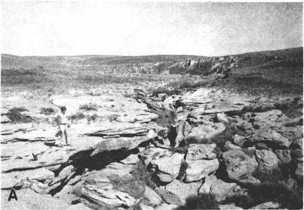
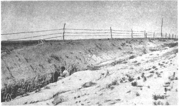
Character--The lower part of this formation consists of thin-bedded, dominantly fine-grained sand. In Meade County it unconformably overlies the Meade formation and is channeled into it, as shown in plate 3A. This sand grades upward into silt and sandy silt, as shown in plate 4A, and loess. The upper part of the formation contains nodules, bands, and stringers of calcium carbonate. The predominant color of these deposits is light tan, although buff and gray beds have been observed. This formation for the most part is confined to the uplands although it constitutes the upper part of sink-hole fills in some localities and spreads over part of the floor of the meade basin north of Meade.
Age and fossils--The stratigraphic position of the Kingsdown silt, unconformably above the Meade formation, restricts its age to uppermost Pleistocene and Recent. The only fossils recovered from the formation, Taxidea taxus (Schreber), Cynomys ludoviciamus Ord, and Bison bison Linneaus, are identical with forms living in Meade County during the Recent epoch.
Plate 3A--Volcanic ash of the Meade formation. Thin-bedded, fine-grained channel sands of the Kingsdown silt, overlying interbedded volcanic ash and silt of the Meade formation, along Kansas highway 23, 8 miles north of Meade, Meade County, Kansas.
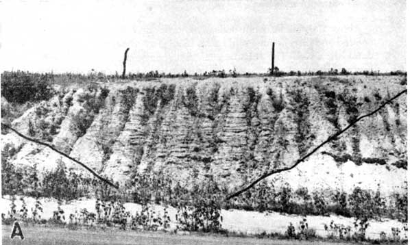
Plate 4A--Kingsdown silt in the area of the type locality, in the SW SE sec. 34, T. 28 S., R. 23 W., southwest of Kingsdown, Ford County.
Terrace Deposits, Alluvium, and Dune Sand
The terraces, sand dunes, and alluvium in this area are primarily of physiographic rather than stratigraphic interest, hence they will be mentioned only briefly here. A detailed discussion will be given in a subsequent publication.
Along the Cimarron valley there is a terrace, the crest of which attains a maximum height of 100 feet or more above stream level. This terrace is underlain by beds of gravel and sand that are channeled against beds of the Meade and Ogallala formations. Teeth of Paraelephas columbi (Falconer) have been taken from these deposits at a point on the north side of the Cimarron valley, south of Meade.
A terrace about 10 feet above flood-plain level occurs along Crooked Creek south of Meade. The material composing this terrace is dominantly sand and silt and overlies beds of Pleistocene and Pliocene age. Although mollusks are abundant in this material no vertebrates have as yet been collected. The extensive terrace deposits of the Englewood and Ashland basins to the east of this area extend up Sand Creek and adjacent stream valleys. The presence of Bison bison, remains of domestic sheep, and Recent mollusks indicates that the upper part of these terrace deposits is Recent in age.
Recent alluvium occurs along Crooked Creek valley, particularly north of Meade where small-scale natural levees have been built (Frye, 1941), and also along Cimarron valley, but little is known concerning its character or thickness.
Eolian sand occurs on the upland in southern and southwestern Meade County and eastern Seward County, and in the tri-county area northeast of Fowler. It also occurs on the upper surface of the terrace deposits of the Englewood basin in southeastern Meade County and southwestern Clark County, and on the valley flat of Cimarron River. Smith (1940, pp. 127-128 and 153-168) has given an excellent discussion of the occurrence of dune sand in this area and in other parts of the High Plains region, therefore no further discussion is offered here. These dunes have yielded only remains of Bison bison and domestic horses and cattle, indicating that in general they are very young.
Baker, F. C., 1938, New land and freshwater Mollusca from the upper Pliocene of Kansas and a new species of Gyraulus from early Pleistocene strata: Nautilus, vol. 51, pp. 126-131.
Chaney, R. W., and Elias, M. K., 1936, Late Tertiary floras from the High Plains; with a chapter by Curtis J. Hesse on the lower Pliocene vertebrate fossils from the Ogallala formation (Laverne zone) of Beaver County, Oklahoma: Carnegie lnst. Washington Pub. 476, pp. 1-46, fig. 1, pls. 1-7.
Cragin, F. W., 1891, On a leaf-bearing terrane in the Loup Fork: Am. Geologist, vol. 8, pp. 29-32.
Cragin, F. W., 1896, Preliminary notice of three late Neocene terranes: Colorado College Studies, vol. 6, pp. 53-54.
Darton, N. H., 1899, Preliminary report on the geology and water resources of Nebraska west of the 103d meridian: U.S. Geol. Survey 19th Ann. Rept., 4, pp. 719-785. Reprinted as U.S. Geol. Survey Prof. Paper 17 (1903).
Elias, M. K., 1931, The geology of Wallace County, Kansas: Kansas Geol. Survey Bull. 18, pp. 1-254, figs. 1-7, pls. 1-42 (including maps). [available online]
Fenneman, N. M., 1931, Physiography of western United States: pp. 1-534, figs. 1-173, map, New York, McGraw-Hill Co.
Frye, J. C., 1940, A preliminary report on the water supply of the Meade artesian basin, Meade County, Kansas: Kansas Geol. Survey Bull. 35, pp. 1-39, figs. 1-7, pls. 1-5. [available online]
Frye, J. C., 1941, Some small scale natural levees in a semi-arid region: Jour. Geomorphology, vol. 4, no. 2, pp. 133-137, figs. 1, 2.
Gould, C. N., and Lonsdale, J. T., 1926, Geology of Beaver County, Oklahoma: Okla. Geol. Survey Bull. 38, pp. 1-71.
Hanna, G. Dallas, 1932, Pliocene Diatoms of Wallace County, Kansas: Kansas Univ. Sci. Bull., vol. 33, pp. 369-395, pl. 31-34.
Haworth, Erasmus, 1896, Local deformation of strata in Meade County, Kansas, and adjoining territory: Am. Jour. Sci., 4th ser., vol. 2, pp. 368-373, map.
Haworth, Erasmus, 1897, Underground waters of southwestern Kansas: U.S. Geol. Survey Water-Supply Paper 6, pp. 1-65 map.
Haworth, Erasmus, 1897a, Physiography of western Kansas: Kansas Univ. Geol. Survey, vol. 2, pp. 11-49. [available online]
Haworth, Erasmus, 1897b, Physical properties of the Tertiary: Kansas Univ. Geol. Survey, vol. 2, pp. 247-284. [available online]
Hay, O. P., 1917, On a collection of fossil vertebrates made by Dr. F. W. Cragin in the Equus beds of Kansas: Kansas Univ. Sci. Bull., vol. 10, pp. 3957.
Hesse, C. J., 1935, New evidence on the ancestry of Antilocapra americana: Jour. Mammology, vol. 16, pp. 307-217, figs. 1-5.
Hibbard, C. W., 1938, An upper Pliocene fauna from Meade County, Kansas: Kansas Acad. Sci. Trans., vol. 40, pp. 239-265, figs. 1-2, pls. 1-5.
Hibbard, C. W., 1938a, Notes on some vertebrates from the Pleistocene of Kansas: Kansas Acad. Sci. Trans., vol. 40, pp. 233-237, pl. 1.
Hibbard, C. W., 1939, Four new rabbits from the upper Pliocene of Kansas: Am. Midland Naturalist, vol. 21, pp. 506-513, figs. 1-4.
Hibbard, C. W., 1939a, Notes on some mammals from the Pleistocene of Kansas: Kansas Acad. Sci. Trans., vol. 42, pp. 463-479, pls. 1-5.
Hibbard, C. W., 1939b, Notes on additional fauna of Edson quarry of the middle Pliocene of Kansas: Kansas Acad. Sci. Trans., vol. 42, pp. 457-462.
Hibbard, C. W., 1940, A new Pleistocene fauna from Meade County, Kansas: Kansas Acad. Sci., Trans., vol. 43, pp. 417-425.
Hibbard, C. W., 1940a, A new Synaptomys from the Pleistocene: Univ. Kansas Sci. Bull., vol. 41, pp. 367-371.
Hibbard, C. W., 1941, New mammals from the Rexroad fauna, upper Pliocene of Kansas: Am. Midland Naturalist, vol. 26, no. 2, pp. 337-368.
Hibbard, C. W., 1941a, The Borchers fauna, a new Pleistocene interglacial fauna from Meade County, Kansas: Kansas Geol. Survey Bull. 38, pt. 7, pp. 197-220, pls. 1, 2. [available online]
Johnson, W. D., 1901, The High Plains and their utilization: U.S. Geol. Survey 21st Ann. Rept., pt. 4, pp. 601-741, maps.
Johnson, W. D., 1902, The High Plains and their utilization (sequel): U.S. Geol. Survey 22nd Ann. Rept., pt. 4, pp. 631-669.
Moore, R. C., and Landes, K. K., 1937, Geologic map of Kansas, scale 1: 500,000, Kansas Geol. Survey.
Smith, H. T. U., 1940, Geologic studies in southwestern Kansas: Kansas Geol. Survey Bull. 34, pp. 1-212, figs. 1-22, pls. 1-34. [available online]
Stirton, R. A., 1935, A review of the Tertiary beavers: Univ. California Publications, Bull. Dept. Geol. Sci., vol. 23, no. 13, pp. 391-458.
Taylor, E. H., 1941, Extinct lizards from Upper Pliocene deposits of Kansas: Kansas Geol. Survey Bull. 38, pt. 5, pp. 165-176, figs. 1-6. [available online]
Kansas Geological Survey, Geology
Placed on web June 28, 2007; originally published in Dec. 1941.
Comments to webadmin@kgs.ku.edu
The URL for this page is http://www.kgs.ku.edu/Publications/Bulletins/38_13/index.html