![]()
Prev Page--Regions || Next Page--Plates
Ground Water in the McPherson District, Kansas
S. W. Lohman
The following discussion treats only of the occurrence of ground water in the unconsolidated Tertiary and Quaternary beds in the district; the ground-water conditions in the older rocks in the district have been described adequately In preceding pages by R. C. Moore. The unconsolidated deposits of the McPherson district comprise the Emma Creek formation of Pliocene age, the McPherson formation (restricted) of Pleistocene age, Pleistocene loess, and Pleistocene and Recent alluvium and dunes.
The Emma Creek formation crops out over a large area in southeastern McPherson County and northern Harvey County. It comprises beds of clay, silt, sand, and gravel, and ranges in thickness from less than ten feet to about 180 feet. The content of sand and gravel is low, except locally in channels, and in general the Emma Creek is only a fair water bearer. The waters are of good quality, except in places where they have been contaminated by oil-field brines.
The McPherson formation (restricted) occupies the filled channel of an ancient stream that once united Smoky Hill and Arkansas rivers. Although it consists in part of silt and clay, it contains beds of coarse sand and gravel that generally yield large supplies of good water. Two of the municipal wells at McPherson yield 1,400 and 2,000 gallons a minute. In the vicinity of Halstead the McPherson waters are of very good quality and have a hardness of less than 150 parts per million. The McPherson waters are much harder near the city of McPherson, and in some places south of McPherson these waters contain appreciable amounts of iron.
In the vicinity of McPherson the formations described above are covered with a mantle of loess that is more than 100 feet thick locally. This fine-grained material yields virtually no water to wells, and where thick, as at McPherson, it prevents or greatly retards movement of rainfall into underlying water-bearing formations.
Sand dunes occupy a hilly belt about five miles wide that extends from a point north of Hutchinson and Burrton eastward to Little Arkansas river. The dune sand is very porous, and, where free of soil or vegetation, is able to take up considerable water from rainfall. The sand is very fine-grained and therefore supplies but little water directly to wells, but a large part of the recharge received by the dunes migrates into adjacent formations where it becomes available for recovery by wells.
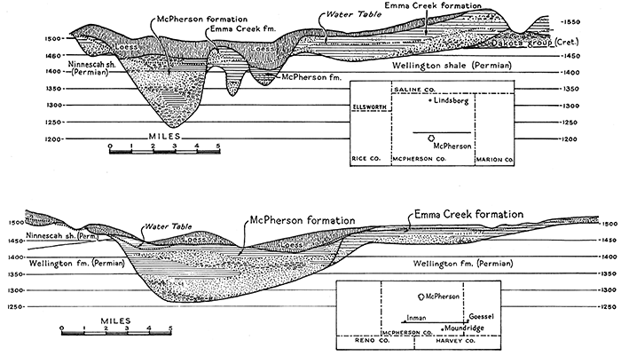
Figure 25--Geologic sections of water-bearing alluvial deposits belonging to the Emma Creek (Tertiary) and McPherson (Quaternary) formations in McPherson County. Very large quantities of good ground water are obtainable from the McPherson deposits. (J. C. Frye.)
The alluvium of the Arkansas valley is the most productive water bearer in the McPherson district. Although the alluvium is more than 250 feet thick in some places, in general the most productive gravels and sands occur within a depth of 75 to 100 feet. The yields from properly constructed wells range from 750 to more than 2,000 gallons a minute. The alluvium supplies the cities of Wichita, Hutchinson, Burrton, Sedgwick, and Valley Center. The water in the alluvium is of good quality except that obtained from a belt about a mile wide on both sides of Arkansas river, in which belt the water is hard and saline, and that from places in which it has been contaminated by oil-field brines.
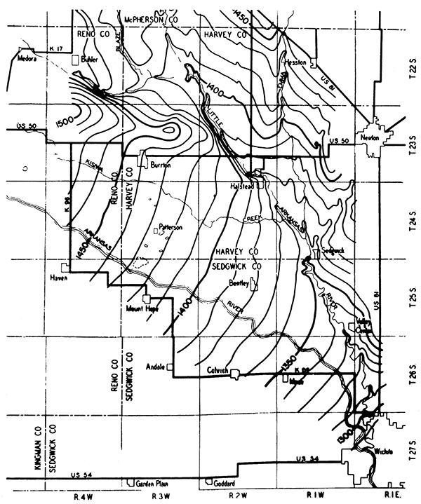
Figure 26--Map of the ground-water table in an area surrounding Halstead, Kan. The progressively lower elevation of the table from northwest to southeast indicates that the general direction of ground-water movement is southeastward. The relatively high position of the table adjacent to the sand-hills area northeast of Hutchinson reflects the influence of favorable recharge conditions in the sand area.
A detailed report is now in preparation describing the geology and occurrence of ground water in the McPherson district. This report is based on field and laboratory studies conducted by the GroundWater Division of the United States Geological Survey, working in cooperation with the State Geological Survey of Kansas and the State Board of Health, with support for part of the investigation, also, provided by the City of Wichita.
Occurrence of Ground Water in Ford County, Kansas
by H. A. Waite
The occurrence of ground water in Ford County may be classified under three separate hydrologic units: (1) The Arkansas valley alluvium; (2) the Upland Plains, underlain to depths of 200 feet or more by the Ogallala formation; and (3) a shallow-water region in the northeastern one-fourth of the county that is underlain by the Dakota sandstone.
Abundant supplies of potable ground water are obtained from wells that penetrate the alluvial sands and gravels of the Arkansas valley. Numerous wells have also been drilled into the basal sands and gravels of the Ogallala formation, which underlies the alluvium, for domestic, municipal, irrigation, and industrial purposes.
In 1938 there were about 190 large and small irrigation wells in the Arkansas valley. Approximately 130 of these were located near Dodge City. The yields of irrigation wells in the valley ranged from 50 to 1,500 gallons a minute. The municipal wells and nearly all industrial wells at Dodge City are deriving water from the Ogallala formation.
The basal sands and gravels of the Ogallala formation are the source of ground water for the Upland Plains areas of the county, with the exception of the shallow-water region in the northeastern part, where the Dakota sandstone is present at relatively shallow depth over a large area. In this district the depth to water ranges from about 20 to 80 feet. Some of the wells obtain water from the Ogallala formation, which in most places mantles the Dakota sandstone, but many more wells tap the underlying Dakota sandstone and derive adequate supplies of water of good quality. There is evidence of a mingling of the Ogallala and Dakota waters in this region.
The depths of wells in Ford County range from about ten feet in the Arkansas valley bottom to 250 feet or more on the Upland Plains. The depth to water below the land surface ranges from a few feet in the valley wells to about 200 feet in the upland wells. In the southwestern corner of the county the wells are shallow, the depths to water ranging from a few feet to about fifty feet. This part of the county is the northeastern extension of the Meade artesian basin and is topographically lower than the surrounding plains country, particularly in the vicinity of Crooked creek. Small flowing wells are encountered in a belt extending a half mile or more on each side of Crooked creek. The wells range in depth from about 100 to 250 feet and flow 1 or 2 gallons a minute. The water is derived from the underlying Quaternary and Tertiary formations.
In general, the ground waters of Ford County are moderately hard; the amount of total solids ranges from about 200 to 400 parts per million, and averages about 250 parts per million. Several samples of water from Ogallala and Dakota sources show a fluoride concentration exceeding 1.5 parts per million, which is sufficient to cause some damage to children's teeth.
A report on the ground-water resources of Ford County, based on studies begun by the federal and state Geological Surveys in October, 1938, is now being prepared.
Ground Water in the Meade Artesian Basin, Southwestern Kansas
by John C. Frye
This report is a very brief preliminary statement of the conditions of ground-water occurrence in a part of Meade County and southwestern Ford County, Kansas, as determined by cooperative federal and state Geological Survey studies that have been initiated in the area.
The Meade district is of particular interest primarily because it contains the only artesian basin of appreciable extent in the state, outside of the broad Dakota basin, which embraces parts of several Great Plains states. The first flowing well in the Meade basin was drilled in 1886, and since that time approximately 1,000 wells have been drilled, but only a very few of these are in usable condition at the present time.
The area within which flowing wells may be obtained is sharply defined, and is controlled by the structure of the rocks underlying the area. The eastern edge of the artesian basin is defined by a fault, or break in the rock strata. This is particularly prominent south of Meade. The rocks west of this fault dip to the east-southeast, and in places where the land surface is sufficiently low, flowing wells may be obtained. The eastern edge of Crooked creek valley, in general, closely parallels this fault. North of Meade, solution of salt and gypsum beds in the underlying Permian rocks has caused the surface to be lowered, so that the area containing flowing wells is much wider.
The wells range in depth from 60 to 350 feet, and as many as three water-bearing zones may be encountered in a single well. In northeastern Meade County and southwestern Ford County, the deepest bed from which flowing water may be obtained is the Dakota sandstone. Over the entire area artesian water occurs in the Tertiary rocks, and locally also in the Pleistocene rocks. The water-bearing beds are separated and overlain by beds of silt and clay that are relatively impervious. These impervious beds confine the water in the sand, and as the- area of recharge to the northwest is higher than the land surface in the basin, enough pressure is developed to lift the water to the surface so that it flows from wells without pumping.
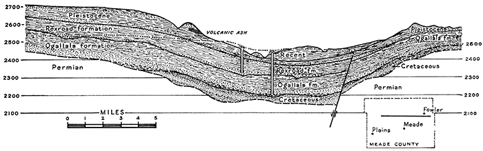
Figure 27--Geologic section of a portion of the Meade artesian basin, Meade County. Structural conditions that are responsible for the local artesian flow of wells are represented. The pre-Tertiary and Ogallala rocks are displaced by a fault that is observed to mark the local boundary of distribution of certain Pleistocene deposits (lower and middle Rexroad beds), which indicates that the displacement is mostly pre-Pleistocene in date. The thickness of Cretaceous rocks and the structure of the pre-Tertiary rocks are interpreted from studies in adjacent areas; they are not based on information from wells in this region. (J. C. Frye.)
From very meager data it appears that the artesian pressure in this basin has declined only slightly in the last forty years. It is reported that in 1900 the water in some wells rose as much as 22 feet above the surface. The strongest wells in the area at the present time have heads of 17 to 18 feet. The flows range from less than one gallon a minute to 100 gallons a minute. The artesian water is relatively soft; however, some waters contain considerable fluoride. It is interesting to note that south of Meade, west of the fault, the sodium chloride content of the water is less than 25 parts per million, whereas east of the fault it is several hundred parts per million.
In the parts of Meade County adjacent to the artesian basin, water occurs in Permian and Tertiary rocks. The depth to water is more than 200 feet in a few places in the western and southern parts of the county.
Ground Water in the Scott District, Scott and Finney Counties, Kansas
by H. A. Waite
The greater part of the area comprising the Scott District is in central and southern Scott County, but a part of the area extends southward into northern Finney County. This so-called shallow-water basin derives its name from the fact that water is obtained at depths ranging from 20 to 90 feet and that there is no surface drainage from the area. The land surface is for the most part flat and smooth, and the region is characterized by numerous shallow undrained basins.
Whitewoman creek, which has a drainage area of approximately 1,175 square miles, terminates in a large depressional area just south of Scott City. Occasional flood flow from Whitewoman creek deploys over this broad sink forming a shallow lake for short periods, and contributes water to the underground reservoir.
The importance of the ground-water resources in the Scott County shallow-water area has long been recognized. The development and use of ground water for supplemental irrigation began about 1910. Probably the greatest development has been made as a result of the prolonged drought during the last decade. According to records of the Division of Water Resources of the State Board of Agriculture, the irrigated acreage in the Scott basin has increased steadily from 1,021 acres in 1932, to 3,859 acres in 1934, to 5,300 acres in 1936, and to more than 12,000 acres in 1939-more than twice the acreage irrigated in 1936. At the end of 1936 there were approximately forty operating irrigation wells in the area, whereas at the end of 1938 there were more than sixty. Several new irrigation wells were drilled in 1939.
The Ogallala formation supplies all the wells in the Scott district. The Ogallala beds are composed of complexly interbedded lenses of clay, silt, sand, and gravel, and their total thickness in the area ranges from about 80 to 150 feet. This formation rests on an uneven, impervious floor of Cretaceous chalky shale belonging to the Niobrara formation. Sand and gravel generally are most abundant in the middle and lower parts of the Ogallala. The yields of irrigation wells in the Scott basin range from about 500 to 2,000 gallons a minute. One well, when operated to maximum capacity on state test, produced 2,900 gallons a minute and the draw-down was 30.7 feet.
An investigation of the geology and ground-water resources of Scott County was started in October, 1939, and will be continued during the field season of 1940. The water levels in 29 observation wells, selected at strategic points throughout the entire area, are being measured monthly in order to obtain essential information concerning the effects of recharge and depletion of the ground-water reservoir. Two wells of this group are equipped with automatic water-stage recorders for the purpose of obtaining continuous records of water-level fluctuation. The Division of Water Resources of the State Board of Agriculture has maintained similar records on two other wells in the same area for several years. The study of trends in movement of water levels in areas such as the Scott basin is very important in measuring periodically the effects of pumpage and in determining the safe yield of the water-bearing formations.
Ground-water Investigations in the Stanton District, Southwestern Kansas
by Thad G. McLaughlin and Bruce F. Latta
The following statement gives a preliminary account of studies of the occurrence of ground water in Stanton and Morton counties, Kansas, undertaken by the United States Geological Survey and the Kansas Geological Survey. Work in this region was begun in July, 1939.
Wells in Morton and Stanton counties obtain water from one or more of four geologic divisions: (1) the Ogallala formation of Tertiary age, (2) the Dakota group of Cretaceous age, (3) the Triassic (?) red beds, and (4) the Permian red beds.
The sands and gravels of the Ogallala formation are the most productive water bearers. They provide water to about two-thirds of the wells in the two counties.
The Dakota group is second in importance as a water bearer, and yields abundant supplies of water to wells in northwestern Morton County, western Stanton County, and southwestern Hamilton County. The Dakota consists of two water-bearing sandstones separated by shale. Of the two sandstones, the lower is coarser grained and by far the better water bearer.
Triassic (?) red beds yield moderate supplies to a few wells in southwestern Morton County.
The depth to water level ranges from less than 10 feet. to about 250 feet. Shallow water, less than 100 feet below the land surface, may be found in about half the area. The principal shallow-water localities are the northeastern part of the area, including eastern Stanton County and northeastern Morton County; the western part of the area, including northwestern Morton County and southwestern Stanton County; and a narrow strip along Cimarron river in south-central Morton County. Deep-water areas, in which the water level stands more than 200 feet below the land surface, are found in southern Morton County and south-central Stanton County.
Several artesian wells, ranging in depth from 200 to 600 feet, have been drilled in western Morton County. The water in these wells comes from red sandstones of Permian age. This water is highly mineralized, excessively hard, and unsuited for domestic use. One sample, obtained from a flowing well at Richfield, has a hardness of 1,935 parts per million, chiefly calcium and magnesium sulphate.
The water from both the Ogallala and the Dakota is hard, the average hardness being about 225 parts per million. Thirty-three of the 76 samples of water analyzed contained more than 1.5 parts per million of fluoride, which is an amount sufficient to produce mottled enamel on children's teeth. In general, the water from the Ogallala in this area is of better quality than the water from the Dakota.
The most suitable area for irrigation in Stanton County is the eastern and northeastern part; here large yields of water may be had from the Ogallala formation at relatively shallow depths. At the present time five wells in this area are pumping water for irrigation and of these, three have been drilled within the last year. They range in depth from 83 to 280 feet, and the depth to water level ranges from 52 to 63 feet.
One well is 182 feet deep, the static water level is 63 feet below the surface, the yield is 800 gallons a minute, and the reported drawdown is 27 feet. Another well is 280 feet deep, the static water level is 56 feet below the surface, the yield is 650 gallons a minute, and the reported draw-down is only 13 feet.
The most favorable areas for irrigation in Morton County are the northwest corner, the northeast corner, and the central-eastern part, between Rolla and Cimarron river. Seven irrigation wells have been drilled, of which three are now in use. One well has a reported yield of 750 gallons a minute. The depths of the wells in the northeast and northwest parts range from 60 to 100 feet, and static water levels are 30 to 80 feet below the land surface. In the central-eastern part, the wells are about 400 feet or more in depth, and the static water levels are 85 to 100 feet below the land surface.
Gaging the Ground-water Reservoirs of Kansas
by S. W. Lohman
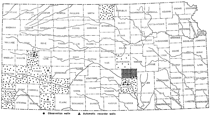
Of special importance in ground-water investigations are the periodic measurement of water levels in numerous observation wells, in order to determine the magnitude and character of water-level fluctuations and the rate at which the underground reservoirs are being replenished by rainfall or depleted by seepage from springs or swamps, by direct evaporation, by plant transpiration, or by heavy pumping. The federal and state Geological Surveys now obtain accurate records of water-level fluctuations in 436 wells located in 13 western counties of Kansas, as shown in figure 28. Part of these records are obtained through the cooperation of the Soil Conservation Service at Mankato and of the city of Wichita.
In most of these wells the water level is measured weekly or monthly, but in a few it is measured quarterly. Nine of these wells are equipped with weekly automatic water-stage recorders that give a continuous record of all fluctuations and permit detailed study (see fig. 9). In addition to these wells, three other wells equipped with recorders in the shallow-water area of Scott and Finney counties have been under observation for eight or nine years by the Division of Water Resources of the Kansas State Board of Agriculture.
The value of periodic water-level measurements is in direct proportion to the length and continuity of the record, as is true of stream-flow measurements. The importance of such long-time records of ground-water levels has been realized more fully in recent years, particularly during the droughts of the last decade. The United States Geological Survey now publishes annually a water-supply paper devoted to tabulated measurements of water levels and artesian pressure in observation wells in the United States, including records from one or more projects in about 28 states and the territory of Hawaii (‡). The 1939 volume, now in preparation, will include 10 separate sections for Kansas, containing records of water levels in about 364 of the 439 observation wells in the state, It is hoped that in the future many more wells in Kansas will be selected for periodic observation and that their distribution will become more widespread throughout the state.
[‡ Water levels and artesian pressure in observation wells in the United States in 1935: U. S. Geol. Survey Water-Supply Paper 777, 268 pp., 1936. Same publication for 1936, Water-Supply Paper 817, 511 pp., 1937. Same publication for 1937, Water-Supply Paper 840, 657 pp., 1938. Same publication for 1938, Water-Supply Paper 845, 724 pp. 1939.]
Figure 28--Map of Kansas showing schematically the distribution of ground-water observation wells, in which water levels are regularly determined by the Geological Survey.
In general, the major fluctuations have been found to be related directly to the amount of precipitation and to changes in the rates of withdrawal. (See fig. 9.) Over a period of years the water level of an underground reservoir may show successive annual declines caused by less than normal recharge from precipitation. Such declines may not indicate a permanent depletion of supply or future failure, but may only indicate a part of a major fluctuation. The water level in such instances may be expected to rise again with a recurring series of wet years.
There may, however, be a withdrawal of ground water for public supply or other use in excess of the normal rate of replenishment, and the water level may suffer net declines year after year, even under conditions of normal rainfall. If the storage capacity of the. underground reservoir is large, this excessive rate of withdrawal may not become apparent for many years unless careful observations are made, and the storage capacity may be seriously depleted before the situation is realized. Failure on the part of many municipalities, irrigation districts, and other users of ground water to collect adequate information in regard to the changes in storage capacity of the ground-water reservoirs may have resulted from a common misapprehension that ground-water supplies are inexhaustible.
It would be unthinkable for a power company to attempt to run a hydroelectric development without knowing at all times the amount of water entering the reservoir, the quantity of water in storage, and the quantity being discharged through the turbines or over the spillway. Unfortunately, however, many large ground-water developments are operated year after year without such essential records being kept. Without such records the gradual depletion of the underground reservoir may escape attention until it is too late and the supply may suddenly fail. Properly kept records of ground-water levels and pump age would show whether the safe yield of the underground reservoir was being exceeded, and whether steps should be taken to augment the supply from other sources or by increasing the recharge by artificial methods.
Prev Page--Regions || Next Page--Plates
Kansas Geological Survey, Geohydrology
Placed on web Dec. 11, 2015; originally published June 25, 1940.
Comments to webadmin@kgs.ku.edu
The URL for this page is http://www.kgs.ku.edu/Publications/Bulletins/27/07_chapt.html