![]()
Prev Page--Introduction || Next Page--Investigations
Geological Conditions Affecting Occurrence of Ground Water
Nature and Distribution of Ground Water
Ground water is defined to include all water beneath the earth's surface that fills the pore spaces or other openings in rocks. The upper surface of this saturated zone is termed the water table. The space between the water table and the surface of the ground is designated as the region of suspended water, for water particles that are present cling to the rock surfaces or are in transit downward to the zone of saturation. Because air may occupy underground spaces above the water table, the zone of suspended water is also termed the zone of aeration.
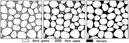
Figure 1--Diagram showing the nature of pore spaces in sand and in sandstone, greatly magnified. Maximum porosity and permeability are found where spaces between the grains are not filled by finer sediment or by cementing material. Most ground water occurs as the filling of pore spaces, and not as freely moving underground streams in cavernous openings of the rocks.
Ground water may be classified as pore water when it occupies small cavities or pore spaces in rocks, as fissure water when it is contained in cracks or fissures intersecting rocks of various sorts, and as cavern water when it fills large passageways dissolved in rocks, as in caves.
Study of the occurrence of water underground calls attention to the necessity of differentiating between so-called fixed ground water and free ground water. The fixed water remains indefinitely in the containing rocks because the capillary attraction in pores of extremely minute size holds the water. Free ground water is that contained in openings sufficiently large to permit relatively easy movement of the water.
Ground-water Reservoirs
Relation to reservoirs above ground
The occurrence of water below the earth's surface is closely related to conditions above ground. One of the natural modes of occurrence of water is vapor in the atmosphere. Moisture or water vapor above the earth, if all precipitated at one time, would make a layer of water about one inch deep over the earth's entire surface. This is not a large amount, but the atmosphere is extremely important as the agency for transporting the water that falls as rain, hail, and snow, and it is the ultimate source of the rivers, lakes, and ground waters.
Large quantities of water lie on the earth's surface. This includes the water of creeks, rivers, and lakes and, in addition, the snow and ice that for long or short periods lies on the surface of continents and islands. This water is fresh. Largest in volume is the great body of ocean water, which is salty. This is important as the chief source of atmospheric water, which in turn supplies the surface waters of land.
Water may be transferred from the atmosphere to the land surface, from the land surface to zones underground and to the atmosphere, or from zones below the ground surface to the surface.
Water movement and storage in the soil zone
Water below the ground surface should be considered in two chief parts-that of the soil zone, and that of the ground-water reservoirs proper. The soil zone consists of mixed mineral and organic matter that is penetrated by roots, its average thickness being about five feet. This zone may be regarded as a water reservoir, its water being in the form of moisture that adheres to the soil particles. Soil structure is more important than soil composition in affecting water content, and the ease or difficulty with which water may penetrate the soil. Although the soil layer is generally only temporarily and occasionally saturated with moisture, on the average it holds water that would measure about one foot if it were separated and concentrated. Inasmuch as crops and other vegetation use one to four feet of water per year, it is evident that water in the soil must be replenished by rainfall or otherwise if crops are to mature. The crop-producing value of a soil depends largely on its capacity to hold water against the pull of gravity and to yield this water to roots of plants. Very sandy soil may retain little moisture even in moderately humid eastern Kansas, supporting only cactus and similar resistant plants. Clay soil may have large moisture-containing capacity that is little benefit to plants. Downward seepage of water from the soil zone can occur only when the soil is fairly well saturated and the water supply exceeds the needs of vegetation. Hence, additions to ground-water supply may be lacking in arid regions.
Most soils are more or less definitely divisible on the basis of physical characters into two or three distinct parts. The upper one comprises the surface soil, which is mainly a zone of decomposition and leaching of mineral matter. The removable of soluble substances, supplemented in many soils by action of burrowing animals, roots of plants, and the like, favors development of an unusually pervious structure. This upper soil is generally absorbent, acting like a sponge to collect rain water and frequently to deliver it to the subsoil and ground-water reservoirs.
Below the surface soil is a subsoil zone, which is characterized by precipitation of materials dissolved from the soil zone above. In addition to various chemical substances, especially calcium carbonate, fine clay may be brought downward to the subsoil. Concentration of such material produces hardpan, which is relatively impervious. In general, however, this zone has a structure that readily permits downward movement of moisture.
A third zone, the substratum, is present in many places and consists of the sediment or bedrock material from which the soil is derived when this is penetrated to some extent by roots. Its character, from the standpoint of water storage and movement, depends largely on that of the bedrock.
Water below the soil zone
Locally in Kansas, the water table lies immediately below the soil zone, or intersects it. Elsewhere, a relatively dry zone of varying thickness occurs between the water table and the soil zone. In most places this dry zone actually contains films of water on rock particles, and the water evaporates very slowly or unites chemically with the rock materials in the course of weathering. As a whole, the zone is characterized by downward migration of water from the soil zone to the saturated area of the main ground-water zone.
We should expect to find that below a certain depth in any region all the pore spaces and larger openings in rock are filled with water that has been supplied by the sinking of part of the rainfall in past years. Deep drilling in Kansas shows that all rocks below a certain depth are normally saturated with water, although only the more permeable strata will yield some of their contained water to wells. Generally, however, the water of all deep zones is much too salty for farm or domestic use and therefore is of no interest to us here. Water at shallow depth, on the other hand, is mostly of good quality for it has not encountered much soluble mineral matter. Inasmuch as deeper spaces in the rocks underground are already water-filled, rain water sinking into the ground can travel downward only so far as unfilled pore spaces and other cavities are found. Beneath a very extensive plain where the water table is approximately horizontal and where possibility of lateral flow of water underground is very slight, continued additions of water from rainfall should result in filling all underground spaces except as the shallowest depths are emptied by capillarity, evaporation, and transpiration by plants. Beneath hilly country, however, there is always the opportunity and tendency for water in the ground to drain toward the valleys. The irregularities of the land surface throughout most of Kansas are sufficient to produce much diversity in the depths to the saturated underground zone in different places. After prolonged rainy periods the spaces beneath the hills are about as well filled with water as those under valleys, but after prolonged drought the water has largely drained from the spaces beneath high land. The principles that apply to this movement of ground water and to the fluctuation of depth to the water-saturated zone may be illustrated by assuming that the number and size of the underground pore spaces in equal rock volumes are the same in two regions, one of which is flat and the other hilly (see A and B in the accompanying diagrams). The freedom of movement of water in each is the same. It is clear that the depth to the permanently water-saturated zone will fluctuate much more in the hilly area than in the plain. In the hilly region (B) the underground water drains from the zones beneath the hills, sinking to a level near that of the deepest valley, but in the plains region (A) there is no opportunity for the underground water to drain, so the water table stays near the surface.
Figure 2--Sketches of a plain (A) and a hilly region (B), showing materials below the surface saturated with water after a period of prolonged rainfall, and depression of the water table after a period of little or no rainfall. Vertical fluctuations of the water table are greater in hilly country.
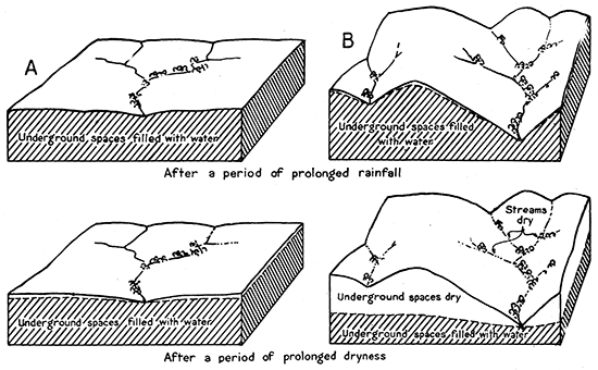
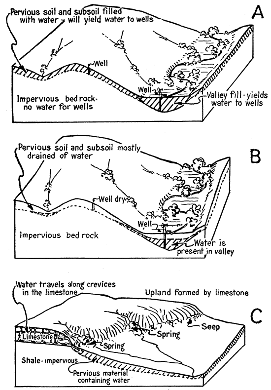
Figure 3--Block diagrams illustrating lateral and downward movement of ground water. The upper figure (A) represents a hilly area in which pervious materials occur only in the valley bottoms and as thin wedges on hillsides; after a rainy period the ground is saturated with water. The middle figure (B) represents the same area after a period of dryness; ground water has drained from the hillside slopes, leaving dry an upland well, but the alluvial valley-fill still contains water supplies. The lower figure (C) shows geological conditions that produce springs at the horizon where pervious limestone rests on impervious shale; ground water in cavities of the limestone, unable to penetrate the fine-grained shale, emerges at various places along the outcrop.
Effect of size of underground cavities
If the number and size of underground cavities in the soil, subsoil, and different kinds of bedrock were approximately uniform, as assumed in the examples just considered (Fig. 2), it would be easy to locate good water wells. Thus, one location in a plains area would be about as good as any other and water could be found at shallow depth anywhere. Wells in any part of a hilly region would likewise obtain water, but it would be necessary to drill much deeper on hills or hillsides than in valleys in order to obtain a steady water supply. A shallow well at or near the top of a hill would go dry as soon as the water table had dropped below the bottom of the well.
As a matter of fact, the number and size of underground cavities in different sorts of rock material are not uniform, but differ enormously. Almost all rocks have some pore space, but in some rocks the cavities are so minute that water, although it will enter the pores, is held so tightly by capillary forces that it will not leave. Such rock, though saturated with water, will yield none of it to a well. If water will not travel through rock material or if its movement is extremely slow, the rock is said to be impervious. Some rocks, such as clay, are impervious, although they have a high porosity, because of the microscopic size of the spaces between the mineral grains. Shale ("soapstone") may be filled with water, but it is mostly of little value as a source of water supply. The pore spaces in sand or sandstone are generally large enough to permit slow but relatively easy flow of water. The passageways between the pebbles of a gravel bed commonly permit movement of water almost as readily as does a pipe, and similarly, passageways widened by solution in limestone allow water to travel freely. Limestone beds that are sufficiently far below the surface to have escaped weathering and those so situated that circulating water cannot readily reach them are not prolific water-bearing rocks.
In very many parts of Kansas where bedrock consists of impervious shale, only the near-surface weathered rock materials consisting of the soil, subsoil, and locally of other unconsolidated material, such as dune sand, certain glacial deposits, slope wash, and alluvium, are sufficiently open-textured to be considered as a source of supply for water wells. The thickness and topographic location of these water-bearing materials are the chief features to consider in searching for the best location for water wells.
Porous rock at shallow depth is all almost saturated with water after a rainy period, uplands and hillsides as well as valley bottoms, but after several weeks or months without rainfall, only the bottom lands will still yield water to wells. Even some valleys may in time be so drained of ground water that wells penetrating alluvial deposits in them fail. The bedrock will yield no water. In such regions, including much of eastern and north-central Kansas, there is no reason to dig wells deeper than the depth where bedrock is encountered, and the best wells are those at the foot of long slopes or in valleys where water in the porous earth above bedrock continues for the longest time to drain into a well.
Bedrock reservoirs
Water is present in most bedrock and it fills the available pore spaces in the saturated zone. Where the pore spaces in the rock are too fine, however, the water cannot be drawn out. Therefore, most bedrock in Kansas consisting of shale, unweathered limestone, and some fine-grained or tightly cemented sandstone, is of no value as a source of water supply for wells. On the other hand, many porous sandstones and limestone beds that have been made porous or even cavernous by weathering are excellent water carriers that yield their contained water readily to wells. Many fine wells obtain their water directly from these porous types of bedrock. The water is more or less evenly distributed through sandstones, but the porosity and permeability of the Tertiary "mortar beds" appears to show considerable diversity. In limestone, the water is mostly confined to certain passageways that have been dissolved along joint cracks and bedding planes. A limestone well may obtain little water if it happens to be drilled in a part of the rock that lack these crevices, whereas a nearby well in the same rock may yield abundant water because it intersects water-bearing channels. Water production from some wells penetrating limestone has been greatly increased by treating the well with hydrochloric acid (30 or more gallons), so as to open or enlarge the passageways for water leading into the well. It should be obeserved that water in porous bedrock moves downward as far as possible, following the gentle inclination of the rock strata, which in most. of Kansas is toward the west. Most springs are located at the bottom of a sandstone- or limestone bed where the water, unable to move downward into underlying impervious rock, finds its way to the surf ace at the outcrop of the pervious bed.
Figure 4--Wells drilled to obtain water from limestone. A. The well shown in the diagram at left happened to miss water-filled openings in the upper limestone and was drilled into a lower bed, but it was unsuccessful in obtaining a good supply of water. B. The well shown in the middle diagram was located in a fortunate manner to intersect good water-bearing fissures in the limestone; this well has a fairly satisfactory yield. C. The right-hand figure shows the effect of acidizing the well represented in the middle diagram; the openings in the limestone have been enlarged by the acid and admit water to the well much more freely.
If an upland area is extensive and not intersected by deep valleys, the occurrence of water underground is comparable to that in a plain. Depending upon supply from rainfall the water accumulates in the near-surface porous rocks and does not drain away readily. One location for a well is about as good as another, except that here also it is best to seek the lower parts of the land surface.
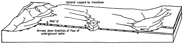
Where water occurs mainly in porous limestone or sandstone that, because of its resistance to erosion, forms the upland, the best water wells will be found at some distance from the outcropping edge of the rock formation in the direction in which the rock layers slope, because the water moves through the porous rock in the direction of dip or inclination of the beds (see Fig. 5). A well (c) that is located considerably down-dip may be expected to obtain a much better supply of water than one (a) near the edge of the escarpment, because it is supplied by a considerable water-collecting area in the higher parts of the rock.
Figure 5--Diagram showing conditions of ground-water supply for wells on a sloping plain formed by a pervious hard formation. The well at a, located near the escarpment formed by the hard rock, is likely to yield water only after times of rainfall, because its catchment area is small and soon drained. Wells at band c are better placed in order to have a steady supply of water. The geological conditions shown here apply to many places in eastern Kansas.
Reservoirs in stream deposits
Generally speaking, valleys are the best places for the location of water wells, (1) because the alluvial fill of valley bottoms is sufficiently pervious in most places to permit water to flow readily into a well, (2) because the water from neighboring slopes drains into the valley, so that a supply is commonly available there even in dry weather, and (3) because the depth to water is generally small. Obviously, the larger the valley and the bigger the drainage basin, the more water may reasonably be expected. Wells on the valley bottom of Kansas and Arkansas rivers, for example, yield sufficient water to supply large cities. The McPherson formation, in central Kansas, is an alluvial deposit that contains billions of gallons of excellent water, supplying wells at a rate of 2,000 gallons a minute or more. The underflow in small valleys may fail in time of prolonged drought, but some small valleys contain an unfailing water supply because they are fed by seepage from water-bearing bedrock that forms part of the valley sides.
Figure 6--Block diagram representing conditions affecting occurrence of ground water in the alluvial deposits of a stream valley. Good water wells may be obtained where the most pervious materials of the valley fill are penetrated, but wells that pass through only fine silt or clay yield little water despite the fact that these sediments are water-saturated. Stream deposits are notably irregular in texture.
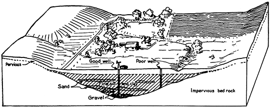
A very important characteristic of alluvial ground-water reservoirs, which affects distribution of the best water wells in valley bottoms, is the fact that the water-bearing rock materials beneath the surface are by no means equally pervious. Clay or silt in the valley bottom may be saturated with water, but the flow of water into a well dug in this material is so slow that the well is quickly drained when pumped. Such a well is of little value. Sand and gravel yield their water freely to wells and accordingly it is desirable to penetrate the coarsest, most pervious parts of the valley filling. In order to find these coarse parts of the valley deposits it is best to resort to tests with an auger, sand bucket, or drill, for the sand and gravel occur in sinuous belts of varying width, often intersecting one another, and in irregular patches and lenses that have no relation, so far as distribution is concerned, to the location of the stream channel in the valley. The coarsest materials in small valleys are commonly found near the middle, in the deepest part of the depression carved in bedrock.
Filling Ground-water Reservoirs
The supply of water to underground reservoirs is affected by numerous factors, most important of which are, (1) the quantity and distribution of rainfall; (2) the perviousness of the reservoir and materials overlying or adjoining it; (3) the size and topography of the intake area of the reservoir, and (4) the effects of evaporation and transpiration.
Amount and Distribution of Rainfall
In general, conditions are most favorable to addition of water to a ground-water reservoir when rainfall is considerable, but well distributed, so that downward-seeping water has time for travel, permitting voids to be refilled by additional rainfall. During short periods of torrential rains, such as visit Kansas frequently, a very large proportion of the precipitation runs off on the surface. The soil layer and superficial openings are quickly saturated with water and time is lacking for downward seepage of this water to make room for additional rain water. As much as fourteen inches of rain has been recorded at a single locality during a storm of a few days in eastern Kansas (Fig. 8). Even if somewhat favorable conditions for entrance of surface water into the underflow exist, little of the water in such a storm can be added to ground-water reservoirs. It is evident that whenever average rainfall is below normal, as during years since 1930, there will be less than normal replenishment to ground-water reservoirs. According to Weather Bureau records, the accumulated rainfall deficiency for the state during the last nine years is about thirty-three inches, this figure being based on averages for the entire state.
Figure 7--Map showing average annual rainfall in Kansas, in inches. An outstanding feature of the climate of Kansas is variation from average conditions, and accordingly, in some years precipitation is materially smaller or greater than the mean.
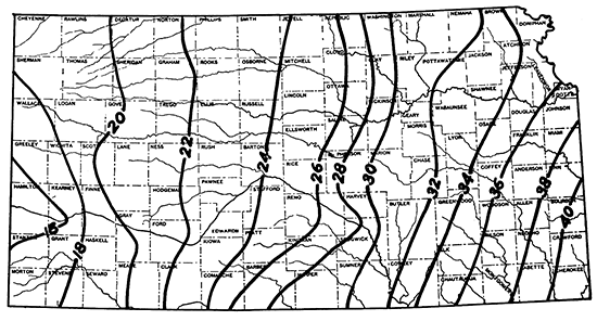
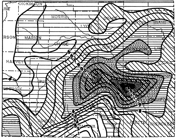
Figure 8--Map of southeastern Kansas counties showing concentrated rainfall during a twelve-day period in April, 1927. The figures indicate inches of rainfall in this period and areas of progressively greater precipitation are represented by increased density of shading (modified from J. O. Jones).
A most important characteristic of rainfall in Kansas is its variability. Some years bring higher than average precipitation and others much lower than average. Groups of successive years, also, may depart from normal in the direction of excess rain or of drought. In a dry year (1894) at Hays, for example, a total precipitation of 11.8 inches was received, whereas in the wettest year (1874), 35.4 inches, which is three times as great, was recorded. The periods of abnormal wetness and dryness appear to run in cycles.
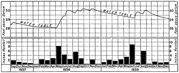
Figure 9--Fluctuations in level of the ground-water table in alluvial deposits at Valley Center, about ten miles north of Wichita, in the 2.5-year period preceding January, 1940, compared with the record of monthly rainfall at Wichita. The varying water level, as recorded by an automatic gauge, shows a slow decline at a fairly uniform rate during the periods of little rainfall, for drainage of ground water from the reservoir then exceeds additions from infiltration of rain water. Relatively sudden rise of the water table is observed to follow promptly the times of considerable local rainfall, indicating that this precipitation tends to recharge the reservoir. (Data from Geological Survey observation well and Weather Bureau records.)
Nature of reservoir and cover
In areas of very pervious bedrock, such as cavernous, fissured limestone in parts of eastern Kansas, or unconsolidated sediments, such as dune-sand areas in central, southern, and western Kansas, a considerable fraction of rain and snowfall finds its way quickly into the underflow. Tracts of land in Butler and Cowley counties, for example, have no surface run-off at all, for the water flows into sinks in the underlying limestone and disappears. Surveys of the water table (see Fig. 26) in dune-sand areas northeast of Hutchinson show that the zone of water saturation rises very noticeably in this district because of the "piling up" of ground water derived from infiltration through the sand. On the other hand, a comparatively impervious surface deposit, such as the widely distributed Sanborn loess in western Kansas, acts as a watertight seal over reservoir beds that lie beneath the surface, retarding or preventing downward seepage of water.
Nature of intake area
It is evident that the placement and structural nature of the ground-water reservoir has important bearing on addition of water supplies to it. If a reservoir is widely distributed and directly underlies the surface or occurs beneath a very pervious cover, there is maximum opportunity for water from the surface to enter it. On the other hand, if the area of inlet to the reservoir is relatively small, the filling of the reservoir is impeded, even though the overlying materials are pervious. Other things being equal, a larger portion of the rainfall runs off as surface flow on steep slopes than on gentle ones or on nearly flat plains. It seems obvious that holding the water on the land surface, as by terracing operations in fields and by construction of lakes and farm ponds, tends to permit. more of the water to sink below the surface and both to retard and to diminish runoff on the surface. There is little question, however, that cultivation tends to decrease the intake capacity of the ground by puddling the top layer of soil and choking available ducts that would remain unclogged under prairie sod. Also, deposition of silt and clay in surface reservoirs may be expected to diminish the percolation of water from them into subsurface channels.
Effects of evaporation and transpiration
The nature and amount of vegetation that is responsible for removal of large quantities of water into the atmosphere by transpiration, and the extent of evaporation are important factors influencing addition of water supplies to ground-water reservoirs. Measurement of evaporation losses indicate that a water surface at Garden City, Kan., yields about seventy inches of water a year to the atmosphere, and in eastern Kansas the annual loss amounts to approximately fifty inches a year. It is certain that a very considerable part of the annual rainfall in Kansas, possibly more than eighty-five percent, is returned to the air by evaporation and transpiration of plants. Stream-flow records account for about 3.5 inches per year of the average annual thirty-three inches of rainfall in Kansas. The remaining 29.5 inches represents evaporation losses, water used by plants and animals (including man), and water added to ground-water reservoirs. The recharging of underground reservoirs is partly, or perhaps wholly offset by discharge from them into surface flow, computed at 0.5 inch per year (and included in 3.5 inches, already noted). There is considerable, but not entirely uniform, evidence of a gradual lowering of the water table in various parts of Kansas during recent decades, pointing to a decrease in ground-water storage. [Note: * R. V. Smrha, discussion of S. W. Lohman, Ground-water Investigations in Kansas (Kansas Engineering Soc., Yearbook, p. 40, 1939), notes that a lowering of water table of ten to fifty feet reported in various parts of Kansas does not accord with information obtained for the period 1890-1934 along a north-south profile through Garden City. This showed that after forty-four years the ground-water level was about three feet lower in the plains country south of Arkansas river and about two feet higher in northern Finney County.] Too few observation wells are available and their record is too short to permit reliable conclusions at present as to whether storage in ground-water reservoirs of Kansas as a whole is being depleted, being held approximately steady, or being increased. The first mentioned is regarded as most likely. In any case, it is not safe or proper to assume that all water from the rainfall that is not accountable as run-off (including water derived from zones below ground) is used by organisms or evaporated; a fraction of the rainfall may constitute a net addition to ground-water reservoirs.
Conservation efforts
As has been noted, the content of ground water in reservoirs below the surface of Kansas is due to an accumulation of downward seepage that has occurred under normal conditions during a considerable past period. Some of this water has come from rain and snowfall soaking into the ground, and some from streams crossing the exposed portions of porous deposits. When water is withdrawn from this storage, it may be recharged, generally very slowly, by natural conditions, or it may become necessary for us to aid in conducting surface waters to underground storage and reservoirs. This may be done through construction of lakes and ponds, through terracing of farm land, by leading surface water into wells that penetrate the underground reservoir, and by the building of dams and diversion ditches along stream courses. Generally speaking, all construction of farm ponds is an asset in conserving ground-water supply, as well as in storing surface water. It is interesting to note that a large proportion of 1,538 dams more than ten feet in height that are reported by George S. Knapp, chief engineer of the Division of Water Resources, to have been completed in Kansas in January, 1940, as well as 3,000 ponds constructed with A. A. A. aid in 1938 and 1939, are located in regions that lack important ground-water reservoirs. The ponds formed by these dams are, nevertheless, effective sources of shallow seepage that may supply wells located below the dams.
There is a common misconception as to the effects of dams along larger streams in conducting water to ground-water reservoirs in the stratified rock. Such dams serve to impound water in parts of the pervious alluvial fill above them and by regulation of flow they serve during drought to prolong the period of production of wells in the valley below them. It is almost wholly impossible, however, for such dams to contribute water effectively to rock strata that form the sides of these valleys. Thus, it is fallacious to assert, as some persons have asserted, that construction of a few such dams along streams in eastern Kansas would result in spreading ground water throughout territory in which reserves of ground water in general are small.
It is very desirable to locate farm wells down drainage from farm ponds. The seepage from the ponds tends to maintain a small but continuous supply of water that moves slowly through the pervious materials to wells thus located. In various parts of Kansas many springs and wells not thus fed from pond seepage quickly go dry during periods of drought.
Underground Movement of Water
Unconfined movement in rocks and sediments
The pull of gravity causes movement of water underground just as it does on the surface, but in general the movement is very much slower. In porous unsaturated rock materials, as loose sand or gravel, the dominant direction of movement is straight downward until the zone of saturation is reached. If, as is almost universally true, the zone of saturation extends higher in the porous materials in some places than in others, the irregularities of the surface of the water table define slopes. In engineering terms, these slopes represent hydraulic gradients, and they determine a lateral movement of the water as it seeks to find a common level. As might be expected, tests show that the rate of movement depends on the steepness of the gradient and on the fineness or coarseness of the openings through which the water passes. Given a slope (hydraulic gradient) of the water table amounting to ten feet per mile, which approximately equals the downstream slope in many Kansas river valleys, water moves through sand of medium grain size at a rate of less than one foot per day and through fine gravel at an average rate only slightly more than ten feet per day. The average rate of ground-water travel in the alluvial fill of the Arkansas river valley in western Kansas has been determined to be about eight feet per day. The eastern slope of the ground-water table in the pervious alluvial materials of the Kansas river flood plain is approximately three feet per mile, and taking account of the average size of pore openings in this fill, it appears that more than a century would be required for ground water to move from Manhattan to Lawrence. This does not mean that if rainfall were utterly to cease in central and eastern Kansas, wells on the river flood plain at Lawrence would continue to yield water 100 years hence, for certain other factors would become felt. It is true, however, that the Lawrence wells would continue to yield water for decades, assuming no withdrawal at points higher in the valley. This emphasizes an essential difference between ground-water supplies and surface water. The latter moves with relative rapidity and is subject to maximum loss by evaporation. Ground water, on the other hand, moves very slowly or, in many places, not at all, and it is not depleted appreciably by evaporation. Flow of surface water fluctuates enormously, according to variation in rainfall, and in periods between rains would cease if it were not for water contributed to valleys from ground-water reservoirs. Even with this addition, surface flow ceases in some streams during times of drought. Ground water is water in storage that remains relatively constant. It may be conserved and augmented or it may be depleted. Ground water is like a slowly accumulated savings account in the bank, which is a reserve to be drawn upon at need, but if expended rashly it is a resource not speedily replaced.
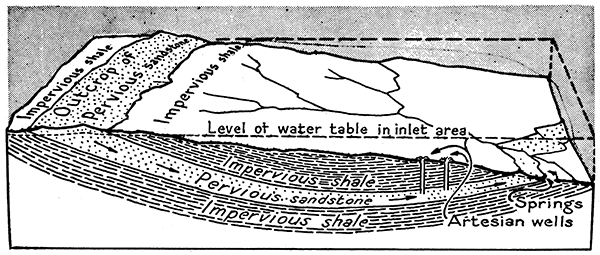
Figure 10--Block diagram showing conditions of geologic structure that are requisite for artesian wells. Water that enters the pervious rocks at the higher outcrops is confined by impervious beds, and hydrostatic pressure is developed that may be sufficient to cause natural flow of water from wells drilled into the pervious strata. The water may emerge as springs at outcrops of the pervious rocks that are topographically lower than outcrops of the inlet area.
Movement of the ground water in stratified rocks follows the same essential principles as in unconsolidated materials such as the alluvial filling of river valleys. The chief differences are due to an average smaller size and generally smaller pore content of these rocks, the general occurrence of alternating pervious and impervious strata, the influence of geologic structure, and the effect of soluble minerals, particularly salt and gypsum, on the waters present in the porous rock. Many layers of bedrock are pervious in the areas close to their outcrops, but are virtually impervious at a distance from these places of exposure. This difference is due to the leaching effects of weathering and to other chemical and physical changes associated with weathering. Many limestone formations that are generally "tight" and dense deep below the surface are traversed at and near the outcrop by a network of openings that may conduct water in considerable quantities. Water in stratified rocks tends to move down in the direction of slope of the layer. In most parts of Kansas such rock layers are tilted at an angle measurable in a few feet per mile. Lateral movement of ground water down the slope of an inclined rock layer is halted when the openings in the formation are entirely filled by water, and accordingly there are many places in which such water reaches a condition of no motion at all.
Movement in porous rook confined by impervious layers
In certain cases, as illustrated by the Dakota sandstone in north-central Kansas and in Colorado, where outcrops of a formation are much lower in one region than in another, water entering at the upper outcrop may find its way underground to emerge at the exposed lower level. In the case of the Dakota sandstone, water enters the formation at outcrops far west of Kansas at the eastern border of the Rocky Mountains. The water migrates slowly eastward and emerges as springs and seeps along the topographically much lower outcrop in Kansas, Nebraska, and other plains states. Confined between impervious shale beds, the water in such a pervious formation as the Dakota sandstone may exert considerable hydrostatic pressure, and where the formation is penetrated by a well, the water may rise close to the surface or flow from the well mouth. Such a well is termed an artesian well. Meade County contains artesian wells that yield water from porous Tertiary and associated beds.
An interesting phenomenon that is observable in some wells is a fluctuation of the water level in accordance with atmospheric pressure. When the barometer falls, indicating decreased air pressure, the water level in the well rises, and conversely. This is due to a partial enclosure of the ground-water reservoir in such a way that changing air pressure forces the water back or allows it to move outward slightly from the confined reservoir. Various Kansas wells show barometric fluctuations of level (see Fig 11).
Figure 11--Fluctuation of the water table in an observation well at Inman, Kan., compared with changes in barometric pressure. The records shown represent a period of about one week during which no water was taken from the well. The barometric curve is inverted in order to show similarity of form to the plotted record of water levels.
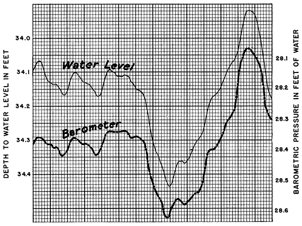
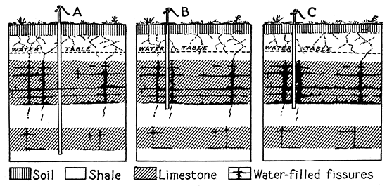
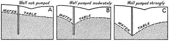
Figure 12--Diagrammatic geologic sections showing position of the ground-water table during a period of no withdrawal of water from a well (A), after a time of moderate pumping of the well (B), and after a time of heavy pumping (C). The cone of depression in the water table surrounding a well commonly increases as the rate of pumping is increased, but in few cases are the outer limits of the cone more than a few tens or scores of feet distant from the well.
Quantity of Water Obtainable from Ground-water Reservoirs
The amount of water that can be obtained from Kansas ground-water reservoirs depends on the areal extent and thickness of the reservoir, its porosity, and the extent to which it is water-filled. There is a difference, however, between amount of obtainable water and what may be termed the safe yield of the ground-water reservoir. The latter takes account of the fact that no ground-water supply is inexhaustible, and utilization of this resource should take account of the manner in which normal conditions operate to recharge the reservoir with new supplies of water. Otherwise demand will exceed the ultimate supply. Numerous cases of overdevelopment that has led to shortage can be cited, and such shortage may be disastrous. For example, excessive withdrawal of ground water in eastern North Dakota and South Dakota, and in the Roswell basin in eastern New Mexico has caused thousands of acres that were very productive to be abandoned. The land has reverted to native vegetation. Where rate of withdrawal from an underground reservoir exceeds the rate of recharge, the falling water table causes a steadily increased cost of lifting by the pump. Eventually, costs are greater than earnings, and communities and industries built on this receding resource decline or vanish.
It is to be remembered that not all of the water contained in a ground-water reservoir is capable of being produced from wells; also, that the rate at which the wells may obtain water from a reservoir varies greatly according to the perviousness of the reservoir, especially near the well. Two wells penetrating the same reservoir may obtain supplies at very different rates, one at only a few gallons a minute and the other at several hundred gallons a minute. The ease of movement of water from a reservoir into a well is commonly measured by the depression of the water table in the vicinity of the well. This cone of depression is very broad and shallow if water flows freely into the well, but is sharp and steep if the sediments are relatively "tight". Heavy pumping may result in such depression of the water table at the location of the well, that is, make such a great draw-down, that production is sharply reduced or stopped until the water has opportunity to flow inward from surrounding areas toward the well.
The amount of water that may be present in a given reservoir can be computed if knowledge is available of the area, thickness, porosity, and degree of saturation in the reservoir. For example, a water-filled sand ten feet thick covering an area of one square mile can supply more than 400 million gallons if the effective yield of the pore space is twenty percent, which is below the average of unconsolidated sands and of some sandstones. The ground-water reservoir north of Wichita, known as the Equus beds, undoubtedly contains billions of gallons of water in spite of the fact that field surveys have shown that only part of this deposit consists of very permeable deposits. Test wells located by the Geological Survey yielded 1,600 to 2,000 gallons a minute. Observations of this sort indicate the greatness of a natural resource, but it is obviously important that supplies of water should not be drawn from such reservoirs at a rate larger than that of their replenishment. Otherwise, the time is bound to come when the resource will no longer be available for use. An objective of the field work of the ground-water geologist is to determine not only the location and approximate quantities of water in underground reservoirs, but to determine what may be regarded as the safe yield.
Quality of Ground Waters
No ground water is chemically pure. Even rain water dissolves small amounts of substances in the atmosphere, and from the moment water starts to move through the soil or other parts of the ground, it takes up various sorts of mineral substances. Some minerals are much more soluble than others, and soluble mineral matter tends to dissolve in increasingly large amounts in proportion as the water has had opportunity to come in contact with it. Many of the ground waters of Kansas show appreciable contents of sodium chloride (salt) and calcium sulphate (gypsum). These make the water unfit for use if their quantities exceed a certain amount. Water containing as much as one-fourth of one percent dissolved mineral matter (2,500 parts per million) has been deemed to have reached the limit of fitness for domestic use by man. Stock water containing more than twice this amount is usable, although not very desirable.
A common constituent of almost all ground waters is calcium bicarbonate, and presence of this mineral in appreciable amounts (about 200 parts per million) makes the water classifiable as "hard". The presence of calcium sulphate and magnesium sulphate gives water a "permanent" hardness. Almost all of the ground-water supplies of Kansas have a moderate hardness, and some are decidedly hard. Iron, silica, and various other substances are common in ground water.
As might be expected, the extent to which ground waters are mineralized bears evident relation to the rock formations in which they occur. Some regions, such as the outcrop belt of Permian rocks that contain thick salt deposits, are noteworthy because of the amount of dissolved salt and gypsum that the waters contain. Likewise, some of the waters from the Dakota sandstone and other Cretaceous strata are salty and gypsiferous. On the other hand, water from the McPherson formation (Equus beds) north of Wichita and widely distributed in the Tertiary deposits of western Kansas has relatively slight mineralization and is relatively soft.
A feature connected with the study of quality of Kansas ground waters is the change in character of water in a given stratum with distance from the outcrop. Water of good quality may be obtained from many formations close to the outcrop, but at a distance of only a few miles from the outcrop, where these formations are buried a few tens or scores of feet, the water obtained from them is found to be so mineralized that it is not fit for use. This means that in its travel from the outcrop to the point where the formation is penetrated in the deeper wells, the water has dissolved so much mineral matter that it is no longer usable.
Virtually all of the water at considerable depth below the surface is very saline and entirely unfit for domestic or stock use. An exception to this generalization are rock formations penetrated in the extreme southeastern part of Kansas. Here, porous limestone (Mississippian) and sandstone (Ordovician) that collect water at their outcrops in the Ozark region of Missouri contain water still sufficiently unmineralized to be suitable for ordinary use. Some of these potable waters are reached at depths of several hundred feet below the surface in Kansas.
Prev Page--Introduction || Next Page--Investigations
Kansas Geological Survey, Geohydrology
Placed on web Dec. 11, 2015; originally published June 25, 1940.
Comments to webadmin@kgs.ku.edu
The URL for this page is http://www.kgs.ku.edu/Publications/Bulletins/27/03_geology.html