![]()
Prev Page--Formations || Next Page--Additional Chapters
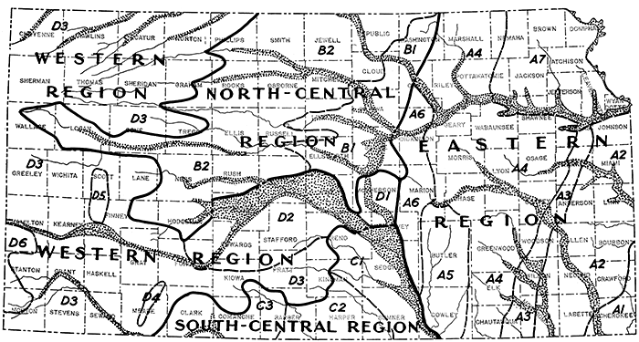
Ground-water Regions of Kansas
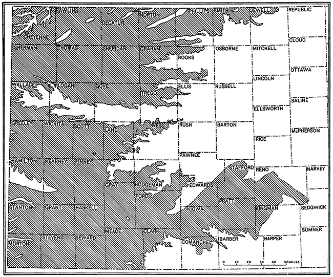
For purposes of brief description of the essential character and extent of the main ground-water resources of Kansas, it is convenient to divide the state into regions that are defined by characters of water-supply conditions. There are four such regions. The boundaries of these regions and subdivisions of them that may be recognized are shown on the accompanying map, designated by letters and numbers.
Figure 19--Ground-water provinces of Kansas. The four regions and subdivisions of them that are indicated on this map are differentiated by prevailing conditions of ground-water occurrence. These conditions reflect essential differences in geologic structure.
A. The eastern Kansas region, comprising the eastern one-third of the state, is essentially characterized by outcrops of Carboniferous and Permian bedrocks that dip gently westward. The topography is characterized by a succession of eastward-facing escarpments; the land surface is moderately rough. As a whole this region is lacking in ground-water reservoirs capable of yielding large quantities of good water, though all the larger stream valleys and a few of the bedrocks yield good supplies.
B. The north-central Kansas region comprises chiefly the area of Cretaceous outcrops. At its eastern margin, the Dakota sandstone provides good water in many places, although in others this water is too salty for use. Otherwise, this region is very similar to the eastern Kansas province in lacking large supplies of ground-water.
C. The south-central Kansas region comprises the Permian redbeds country, in which few good water supplies are obtainable from bedrocks, but in which there are adequate supplies from some of the surficial sediments.
D. The western Kansas region includes the most widespread and one of the most reliable ground-water reservoirs in the state. This consists of a mantle of partly consolidated sediments of comparatively recent geologic origin, which contain large quantities of water of fine quality.
Eastern Kansas Region
In addition to the ground-water reservoirs of major stream valleys, there are seven subdivisions of this region that may be differentiated according to significant variation in conditions of the ground-water supplies.
A-1, Cherokee District
This district includes the southeastern corner of the state, comprising most of the area of Cherokee county and small parts of adjoining Labette, Crawford, and Bourbon counties. The region is characterized by a lowland plains surface topography in which shale and local beds of porous sandstone underlie most of the country. Water is obtainable from the porous soil cover above the shale, and in the near-outcrop portions of the various sandstone beds. Throughout most of this region, also, waters of good quality are obtainable from the Mississippian limestone, 400 to 500 feet thick, which next underlies the relatively impervious Cherokee shale. The water in the Mississippian is derived from rainfall entering the formations at outcrops farther east in Missouri. Several cities, such as Columbus and Pittsburg, obtain supplies for municipal use from deep wells penetrating the Mississippian and underlying rocks.
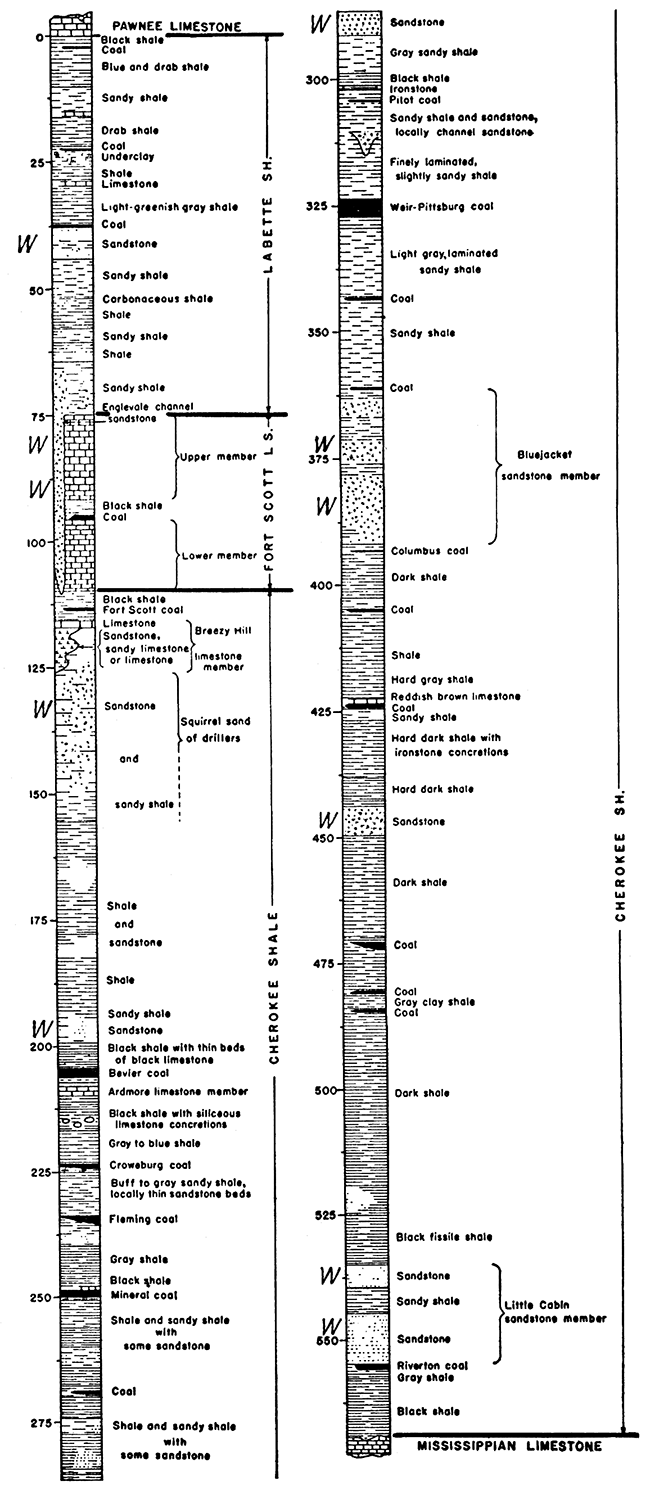
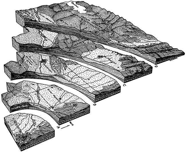
Figure 20--Generalized section of Pennsylvanian rocks exposed in the Cherokee district of southeastern Kansas. Strata that yield good supplies of water locally near their outcrop are indicated by W (W. G. Pierce and W. H. Courtier).
A-2, Neosho District
In this district, named from Neosho county, which typically represents the general ground-water conditions of the district, all or parts of several other counties extending southward from Kansas City to the Oklahoma line are here naturally grouped together because of similarity of the bedrocks, consisting predominantly of shale and escarpment-making limestone. There are few, if any, formations that bear large quantities of water, although supplies adequate for farm wells are found throughout the region in thin surficial porous materials and in the sandy layers of some of the shales. Limestone beds yield water where the formations are close to the surface and where there is an adequate catchment area in which the water may be collected and conducted through fissures and other openings in the rocks to well locations.
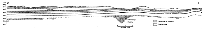
Figure 21--Geologic section in an east-west direction across central Linn County. Limestone beds that occur next below the land surface over many square miles are good sources of ground-water supply. The water is collected in openings dissolved along bedding planes and joint cracks and it tends to migrate slowly in the direction of dip of the beds. (J. M. Jewett.)
A-3, Woodson District
This is a relatively narrow belt crossing Woodson county and reaching from the Oklahoma line to Kansas river. Its trend is a little east of north to west of south. The district comprises the outcrop belt of Pennsylvanian rocks (Douglas group) consisting largely of sandstone and shale that occur between prominent groups of limestone. The sandstone layers are important water-bearing reservoirs in parts of this region and, close to the outcrops, yield water of good quality.
A-4, Lyon District
Larger than any other of the subdivisions of the eastern Kansas region is the district here treated. It is essentially like district A-2 in that the most important geologic elements consist of escarpment-making limestone formations that are separated by relatively impervious clay and calcareous shale. There is little sandstone. Most of the area is distinctly hilly. Ground-water supplies sufficient for ordinary farm and stock use are obtainable from porous surficial deposits and in places from the fissured near-surface limestones, but these ground-water reservoirs are too limited to be of much importance. Farm ponds are especially important as an adjunct to a steady supply of water on farms.
A-5, Butler District
West of the Flint Hills escarpment in south central Kansas is the Butler district, comprising most of Butler and Cowley counties and small parts of Marion and Chase counties. It is differentiated because of the long dip slopes underlain by limestone that yield water collected from the area of the dip slopes. This is a region in which water wells depend almost wholly on locating belts or joints or other openings in the limestone. Wells in these formations may be treated successfully by acid in many cases to increase the freedom of circulation of water in the rocks.
A-6, Marion District
The outcrop area of Permian shales, belonging mostly to the Wellington formation, which comprise a belt from eastern Sedgwick County northward to Clay county, is characterized by the very local and poor quality of the ground-water supplies that may be developed. The water is obtained from surficial materials and the weathered outcrop of more porous strata in the shaly rock. It is generally highly mineralized because of the abundance of gypsum in the underlying bedrock. Also, salt from t.he same beds gives a greater content of sodium chloride than is present in most of the ground waters of the state.
A-7, Jackson District
Northeastern Kansas, comprising counties north of Kansas river and east of central Nemaha and eastern Pottawatomie counties, is essentially characterized by its widespread cover of glacial drift. This entirely conceals the underlying bedrock in most places, although near Missouri river and other large streams there are outcrops of bedrocks. The glacial deposits consist of "boulder clay" and in places of very porous sand and gravel that are good water containers. There are few parts of this district that do not yield good supplies of well water, although the quantities in most places are not large enough to supply communities. There has as yet been no systematic study of the glacial materials in order to determine trends of essentially pervious' gravels that may be better than other parts of the district as ground-water reservoirs. There are virtually no ground-water supplies in the bedrocks at all.
North-central Kansas Region
B-1, Ellsworth District
The outcrop of the Dakota sandstone, which is characterized topographically by the prominent irregular Smoky Hills, constitutes a distinct part of the north-central Kansas region. It is here designated as the Ellsworth district because this area shows very typical features of the geology and water-supply conditions. Wells generally obtain good supplies from either an upper or lower zone in the sandstone. The middle part of the Dakota commonly contains impervious shale. Because of salt or salt-bearing shale in parts of the Dakota deposits, some of the water has become so highly mineralized that it is not fit either for domestic or stock use. Salt marshes occur locally, as in Cloud County.
B-2, Osborne District
The Cretaceous outcrop areas, exclusive of the Dakota Sandstone, are grouped together as the Osborne district. In the eastern part of the belt are shales and thin limestones (Greenhorn) in which water-supply conditions are difficult and the water obtained is generally hard and gypsiferous. The middle part of the belt includes the Niobrara chalk country, in which waters are hard and limy and the formation is comparatively impervious. The thick Pierre shale, overlying the Smoky Hill, is a clayey impervious formation that generally lacks ground-water reservoirs, and in all this district, excepting weathered surficial deposits, there is little or no water to be obtained from wells. Construction of farm ponds and utilization of water carried by shallow streams and other alluvial fillings are the lines of development required in this part of Kansas to assure needed domestic- and stock-water supplies.
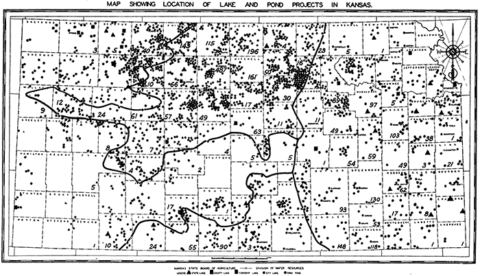
Figure 22--Map showing distribution of lakes and farm ponds that have a maximum depth of ten feet or more in Kansas (modified slightly from map published by the Division of Water Resources, State Board of Agriculture). Also indicated (by figures) is the distribution of more than 3,000 ponds that have a maximum depth of seven feet or more, constructed in 1938 and 1939 with aid of the Agricultural Adjustment Administration.
South-central Kansas Region
C-1, Sumner District
Territory west and south of Arkansas river, extending from central Reno county to southeastern Sumner, is here designated as a subdivision of the south-central Kansas district. It is underlain by gray and red shale belonging to the Sumner and Nippewalla groups of the Permian system. The water-supply conditions are essentially the same as in district A-6.
C-2, Harper District
This portion of the south-central Kansas region comprises almost all of Harper county and adjacent portions of Barber, southern Kingman, and western Sumner counties. It is underlain by Permian red beds consisting largely of fine- to medium-grained sandstone, but also containing some red and gypsiferous shale. The sandy beds are water bearing in places close to the outcrops and the problem of obtaining supplies is somewhat simpler than in the immediately adjoining shale territory farther east. Also, the widespread cover of porous surficial materials of Quaternary age serves as a collector of rainwater and yields this water to wells. There are no large supplies of ground water of good quality in this district.
C-3, Comanche District
From the regions of the gypsum hills in central Barber County westward to the edge of the Tertiary outcrops in southeastern Meade County is a Permian red-beds country in which the rock strata consist predominantly of shale rather than sandstone, and the presence of gypsum tends to make the supplies of ground water hard and highly mineralized. Good supplies of ground water are virtually lacking outside of local deposits in stream valleys.
Figure 23--Dissected block diagram showing the geologic structure of a part of central Kansas lying northwest of Wichita. Chiefly noteworthy are the broad alluvial deposits of the Arkansas valley and the McPherson County region. These fill depressions in the impervious Permian bedrocks and overlap on Dakota and other Cretaceous rocks. Locally there are deposits of dune sand.
Western Kansas Region
D-1, McPherson District
Almost all of McPherson County and northwestern Harvey County are here differentiated, and although located in central Kansas slightly east of the middle line of the state, this district is grouped with the western Kansas region. Such classification is due to the general nature of the water-supply conditions and the fact that the reservoir consists of Tertiary and Quaternary sediments that are mostly unconsolidated. A depression formed in the relatively impervious Permian shale is here filled by sand, gravel, and some clay that was deposited mainly by streams. Recent field studies and test drilling have shown that the deposits may be classed in two main parts, one of which, the older, extends over most of the region as a fairly pervious water-bearing deposit. This is the Emma Creek formation of Pliocene age. In a belt trending southeastward from the vicinity of McPherson is a very porous valley filling in the older materials, the McPherson formation (restricted). This is the main water-bearing zone in the area and may be compared, so far as water conditions are concerned, to alluvial fillings in main stream valleys. The quality of water is excellent and it is utilized by several cities, including McPherson, Inman, Buhler, and Newton. It is interesting to note that the source of the water in these deposits is not the underflow of Smoky Hill river, as commonly supposed, but the reservoir is replenished by rainfall within the district and in part it appears to be fed by seepage from the sand hills along parts of the southwest edge. In this area the ground-water table shows a distinctly higher area as it does also along part of the divide north of McPherson.
A special summary of studies made by Survey geologists in this region is given in a following section by S. W. Lohman.
Fig. 24--Map of western Kansas showing outcrop area of Tertiary deposits.
D-2, Stafford District
Territory surrounding Great Bend and including counties both north and south of Arkansas river, from the eastern edge of Ford County to Harvey County, is here grouped because of the general prevalence of alluvium and sand-hills ground-water conditions. Good water can be obtained almost anywhere, and the sand hills and sandy river bottoms form excellent porous media for the downward seepage of any rainfall in the area. Waters of the underflow of Arkansas river are distinctly salty, especially east of the mouth of Rattlesnake creek. It is apparent that general water movement in the district is slowly northeastward.
D-3, Greeley District
This district comprises all the western Kansas High Plains Tertiary deposits, excepting small areas that are differentiated from it and treated separately hereafter. A northern subdistrict is partly separated from the rest by the excavation of the Smoky Hill river valley. Also, the main district, south of the Smoky Hill, is divided along the line of Arkansas river by the belt of sand-hills deposits just south of that stream. There are no good reasons for recognizing these subdivisions as separate ground-water units, for all the Tertiary district is characterized by occurrence of sheet water in one or two main zones and is characterized further by the irregularly varying, coarse and fine water-bearing grits. The deposits were made by former streams carrying sediments from the Rocky Mountain front. The variations in the coarseness of the Tertiary sediments affect the local water productivity of the deposits importantly. In places where the sediments are coarsest, it is possible to obtain the largest quantities of water from pumping wells. Geologic field studies by M. K. Elias, H. T. U. Smith, and other geologists of the Survey, supplemented by exploration with the drilling machine, has shown the widespread occurrence of loess, a fine, relatively impervious surficial deposit that retards entrance of rain directly into the underflow. It is very difficult to obtain well water from the loess, which in places may be 100 feet or more in thickness.
The water in the Tertiary beds of this district is derived partly from the local rainfall and partly from water brought eastward from Colorado. It is evident from the low rate of surface rainfall and from studies of evaporation and transpiration in western Kansas that the annual rate of ground-water recharge is very low. It is therefore an important part of ground-water investigations in this region to determine the rate of safe use so that this enormously important resource may not be expended unwisely for such things as general crop irrigation. Somewhat intensive agricultural developments, as in the vicinity of Garden City, depend mostly on ground water carried in the underflow of Arkansas river. It is undoubtedly possible and may be deemed desirable to develop various small districts utilizing Tertiary ground water in order to irrigate stock-feed crops for local use.
A summary of field studies of ground-water conditions in Ford County is given by H. A. Waite in a later section of this paper.
D-4, Meade District
This includes a relatively small part of eastern Meade County, comprising mainly the valley of Crooked creek. It is differentiated because of the artesian water conditions that exist in this part of the Tertiary district. Water in pervious strata is confined beneath impervious beds, and the structure of the rock locally is such that the water is confined under pressure and will rise of its own head to the surface. These conditions are peculiarly favorable for development of the ground-water supplies and are being studied from the standpoint of possible local irrigation.
A summary of field conditions, as observed in reconnaissance investigations by J. C. Frye, follows in a separate section.
D-5, Scott District
An area in south-central Scott County and northwestern Finney County is differentiated because of the availability of large quantities of water at relatively shallow depth, and the local use of this water for irrigation. Two water-level observation wells, which have been maintained by the Water Resources Division of the State Board of Agriculture, and 29 observation wells (two equipped with automatic recorders) of the Geological Survey indicate fluctuations of water level with variation in withdrawal from the reservoir by pumping. No exhaustive ground-water studies have yet been completed, but it appears evident that there is no reason to encourage enlargement of irrigation activities to such a point that. withdrawals of water are likely to deplete the reservoir.
A brief discussion of the Scott area is given in a following section by H. A. Waite.
D-6, Stanton District
Western Stanton and adjoining parts of northwestern Morton and western Hamilton counties are separated from the other western Kansas districts because of the cropping out at many points of the Dakota group. The Tertiary cover is thin, and in places it has been removed so as to expose these underlying bedrocks. The water-supply conditions are, therefore, somewhat more variable than in adjoining territory. Also, the water obtained in parts of this district is evidently Dakota water, instead of water obtained from the Tertiary Ogallala deposit.
A summary of reconnaissance studies in this southwestern Kansas district is added in a later section, written by T. G. McLaughlin and Bruce Latta.
Alluvial Deposits
The alluvial deposits of various stream valleys, which are one of the most important sources of ground water in all regions of Kansas, are not differentiated as special districts. All are similar in that the water-bearing materials consist of sand and gravel of various coarseness and the contained water is derived from the streams flowing through the valleys, from seepage from the uplands and sides of the valleys, or from water-bearing formations that crop out in the sides of the valleys. All these factors influence the quantity and quality of the water that is carried in these alluvial deposits. As noted in an earlier section of this paper, the ground water moves very slowly in a downstream direction. It may be depleted in almost any desired degree with the comforting prospect that water from the stream and recurrent rains will generally recharge the reservoir quickly.
Acknowledgments
Preparation of this paper has been aided by data and illustrations provided by S. W. Lohman, H. A. Waite, and J. C. Frye, geologists on the staff of the Division of Ground Water, United States Geological Survey, who are engaged in cooperative studies with the State Geological Survey and the State Board of Health on ground-water resources of Kansas. I am indebted to these men also, and to my colleague, K. K. Landes, for reading of the manuscript and for suggestions. Short reports on ground-water studies in various districts have been contributed by S. W. Lohman, H. A. Waite, J. C. Frye, T. G. McLaughlin, and Bruce Latta. These cooperative ground-water studies are being made under the immediate supervision of S. W. Lohman, geologist in charge of ground-water investigations in Kansas.
Prev Page--Formations || Next Page--Additional Chapters
Kansas Geological Survey, Geohydrology
Placed on web Dec. 11, 2015; originally published June 25, 1940.
Comments to webadmin@kgs.ku.edu
The URL for this page is http://www.kgs.ku.edu/Publications/Bulletins/27/06_regions.html