![]()
Prev Page--Introduction || Next Page--Systematic Ichnology
Sedimentology
The lower interval of the Stull Shale Member at Waverly is subdivided into four vertically stacked parasequences (PA to PD), separated by transgressive surfaces (TS1 to TS4) (fig. 5). These parasequences are described below, from base to top. Each parasequence has been divided into facies units. In facies descriptions, we use the terminology of Allen (1968) for crest ripple patterns, Reineck and Wunderlich (1968) for heterolithic bedding, Dzulynski and Walton (1965) for sole marks, Myrow (1992) for gutter and pot casts, and Retallack (1990) for fossil soils. Density of trace fossils in bedding planes is expressed using the index of Miller and Smail (1997). Representative slabs with sedimentary structures have been reposited at the Kansas Geological Survey in Lawrence, Kansas.
Parasequence A
The base of this para sequence is not exposed and only the top of the package is observed. A mud-dominated heterolithic facies is the only unit recognized.
Unit A1--Mud-dominated Heterolithic Facies
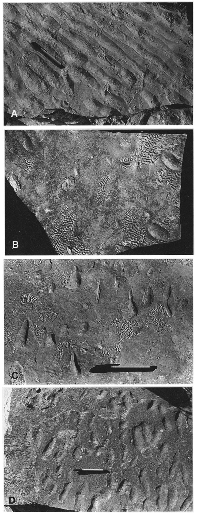
Description--The lower part of the Waverly sequence consists of a 40-cm-thick mudstone-dominated heterolithic unit that can be observed only when the stream bed is dry (fig. 6). The base of this unit is not exposed. Unit A1 consists of gray, structureless mudstones intercalated with heterolithic intervals displaying lenticular bedding with single flat lenses of sandstone, and wavy bedding in the upper part. Small, short (less than 1.5-cm-long) groove marks are present on the soles of wavy sandstone beds. A thin (2-4-cm), laterally persistent (at the scale of about 20 m), sharp-based, very fine grained sandstone unit with flattop ripples (fig. 7A) and sinuous wrinkle marks (also known as runzelmarken or Kinneya) (fig. 7B-D), forming honeycomb-like structures that are patchily distributed between relict and discontinuous ripple troughs, occurs in the upper part of the interval. Although locally amalgamated to form a single bed, this sandstone unit actually consists of a basal bed with wrinkle marks and an upper bed with relict ripple troughs.
Gutter and pot casts are the most striking features of the mud-dominated heterolithic facies, and they are particularly abundant in the upper levels of this unit (figs. 8A-B, 9A-D, 10A-D, 11A-D, and 12). Although preserved in situ, they more commonly are found as float.
Figure 5--Detailed sedimentologic log of the lower interval of the Stull Shale Member at the Waverly trace-fossil locality, showing parasequences, transgressive surfaces, and depositional units discussed in the text. PA to PD = parasequences A to D. TS1 to TS4 = transgressive surfaces 1 to 4. TS4 also is a sequence boundary.
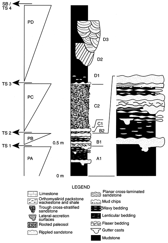
Figure 6--General view of tidal-flat deposits at Waverly. Note laterally persistent sand-flat facies (unit B1) overlying mud- to mixed-flat facies (unit A1).
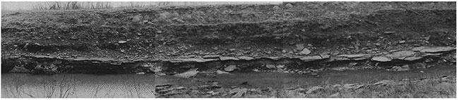
Figure 7--Bedding-plane physical sedimentary structures in unit A1. A. Flat-top ripples. B. Parallel oriented relict troughs and patchily distributed wrinkle marks. C. Relict troughs and associated, patchily distributed wrinkle marks. Note subparallel orientation of relict troughs. D. Relict troughs and more extended wrinkle marks. Pen length is 150 mm.
These erosive structures are diverse in morphology and size. Most of the gutter and pot casts are sand filled, but a few show a distinctive coarse-grained shell lag. Gutter casts commonly are connected to the overlying sandstone unit (fig. 8A-B) or to thin sandstone beds in unit A1. However, some isolated gutter casts (i.e., unconnected to overlying sandstone layers) also are present. Some of these isolated gutter casts are very wide and relatively shallow, resembling small sand lenses, but are distinguished by erosional sole marks at the base. Ripple cross lamination is by far the dominant internal sedimentary structure, but low-angle cross lamination and parallel lamination also have been observed (fig. 9A-D). Both asymmetrical and symmetrical ripples are present. Oscillatory climbing ripples with a high angle of climbing are very common (fig. 9D). Some gutter casts exhibit low-angle truncation surfaces (fig. 9B-C). Although the fill is predominantly a fine-grained sand, ripples are commonly mud-draped. The upper bedding surface commonly is covered with oscillation ripples that may display flat ripple tops or wrinkle marks (fig. 10B, D). In a few cases the top has been almost completely flattened with development of relict troughs (fig. 10D). Of 23 gutter casts observed, 18 (78%) display ripple crests perpendicular or forming an angle of 6500-8000 with the orientation of the gutter axis (fig. 10A-D). In the other five cases (22%), however, the gutter axes are almost parallel to the uppermost ripple crests. Cross sectional shapes range from symmetrical to strongly asymmetrical, from shallow to very deep (fig. 9A-D). Along its course, the cross sectional shape of a gutter may vary substantially (fig. 12A-C). The most common morphologies are U-shaped, V-shaped, square-shaped (i.e., flat-based), and semicircular. Steep, almost vertical and overhanging walls are common. Gutter depth ranges from 8.5 to 86.8 mm, but typically it is around 50 mm. Width is 9.3 to 60.5 mm. Plan-view geometry varies from straight to highly sinuous (fig. 11A-B). In general, smaller, shallower structures are more sinuous. Many gutters display angular turns in the axial direction (fig. 11B). Second-order gutters may join a main course or two gutters may converge forming a deeper structure (fig. 12C). Second-order gutters are, in many cases, smaller and shallower than the gutter to which they join. Several gutters may coalesce, forming an irregular sandstone lense. Pot casts are found in close association to gutters (fig. 11A-B). In most cases, gutter casts originate from pot casts. In other cases, pot casts are connected to the main gutter by an incipient, short, shallow secondary gutter (fig. 12C). Pot casts commonly are circular to crescentic in shape. Some pot casts are deep and pillar-shaped, but most are relatively shallow structures adjacent to gutters. Most gutters exhibit sole marks along the sides and bases. Tool marks, subparallel or oblique to the main axis, are very common. Flutes and grooves are less common. Some gutters display flute marks diagonal to the gutter axis (fig. 11D). Cruziana problematica, which occasionally is present on the sides and bases of gutter casts (fig. 11C), have been found as much as 33.5 mm below the uppermost ripple top.
Figure 8--Close-up of mud- to mixed-flat facies (unit A1) overlain by sand-flat facies (unit B1). A. Large gutter cast incised into the fine-grained facies and connected to the overlying sandstone bed. B. Small gutter cast connected to a sandstone bed. Note thin, lenticular sandstone layer interbedded with the fine-grained deposits. Length of hammer is 33.5 cm.
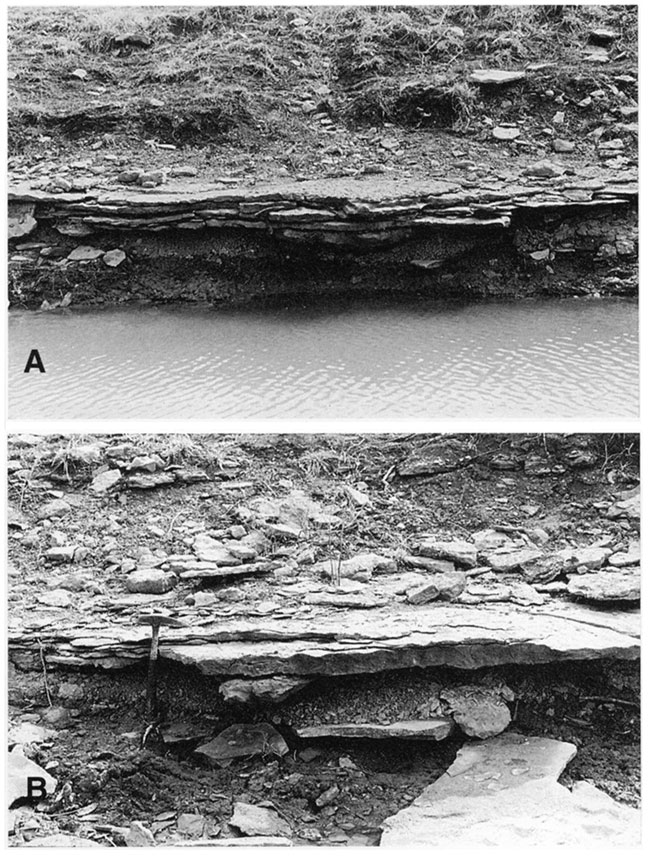
Figure 9--Cross sectional views of gutter casts. All photos x 0.5. A. Shallow, slightly asymmetrical gutter cast. Note rippled top with crest axes almost parallel to gutter axis. B. U-shaped, slightly asymmetrical gutter cast. Note truncation surface close to the base of the gutter and mud drapes. C. Deep, U-shaped, symmetrical gutter cast. Note vertical walls and mud parting (where the sample is broken) in the middle of the gutter. D. Longitudinal cut of a gutter cast showing oscillatory climbing cross-lamination with high angle of climbing.
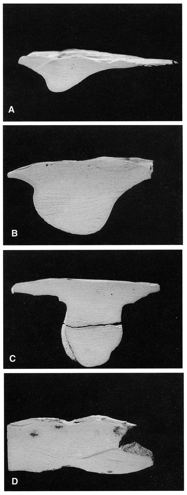
Figure 10--Basal and top views of gutter casts. Photos A, B, and D x 0.27. Photo C x 0.25. A. Converging gutter casts with associated pot casts. Note meandering course of the gutter cast on the right and presence of a pillar pot cast (left) connected to the main erosional structure by an incipient gutter. Basal view. B. Top of A, showing flat-top ripples, wrinkle marks (upper left), and relict troughs (lower right). Ripples oriented perpendicular to gutter casts. Note soft-sediment deformation texture in troughs (center). C. Deep gutter cast originated from a subcircular pot cast with crescentic topographic central high. Basal view. D. Top of C, showing flat-top ripples and relict troughs. Ripples oriented at approximately 45° to the gutter cast.
Figure 11--Basal views of gutter casts. A. Low-sinuosity gutter cast with flattened base and associated crescentic pot hole. Note presence of diagonal tool marks on gutter walls. x 0.26. B. Straight gutter cast exhibiting a sharp angular turn associated with deepening of the structure. Note associated small, circular pot holes (left). x 0.19. C. Relatively shallow gutter cast displaying an ichnofauna dominated by Cruziana problematica. x 0.32. D. Spiralling flute marks in small gutter cast. x 0.37.
A moderate density (degree 3 to 4) of locomotion (Cruziana problematica, Protovirgularia rugosa) and grazing trace fossils (Psammichnites grumula) are preserved on the soles of the sandstone intercalations. Trace fossils are rare within the mudstones; only some specimens of thinly lined Palaeophycus tubularis filled with sand piped down from the overlying facies were observed.
Interpretation--Unit A1 records, for the most part, fallout deposition of mud in a low-energy setting. Vertical accretion of fine-grained sediment was, however, punctuated by tractive sand deposition. Alternation of mud fallout and sand traction is best recorded in the upper part of unit A, where mudstones alternate with lenticular- and wavy-bedded intervals. Tool marks on the soles of the wavy-bedded sandstones indicate erosion by objects dragged through the muddy substrate by a current. Local increases in energy also are reflected by the presence of a distinctive suite of physical sedimentary structures in the thin sandstone unit that occurs in the upper part of the facies A interval. The sharp base of the sandstone bed suggests episodes of relatively strong and erosive currents. Erosion was followed by bedload-flood transport leading to deposition of a rippled sandstone bed, whose crests subsequently were flattened during shallow-water ebb outflow, allowing only the preservation of the structure herein referred to as "relict troughs" (fig. 13A-C). Parts of the troughs were filled by sand flowing from the adjacent ripple crests during emergence, as evinced by substrate deformation in ripple troughs (cf. Reineck and Singh, 1980). The origin of wrinkle marks has been a matter of debate. Reineck (1969) interpreted these structures as produced by wind during stormy weather. Seilacher (1982a) suggested that similar structures referred to as "Kinneya" are related to differential dewatering and settling during storm deposition. A detailed study by Allen (1985) supports an origin related to soft-sediment loading, although not necessarily associated with storms, but with subaerial emergence in intertidal areas. More recently, formation of wrinkle marks was linked to microbial mats (Schieber, 1989, 1990, 1999; Gehling, 1991; Pflüger, 1999; Hagadorn and Bottjer, 1999). These authors concluded that wrinkle marks result from microbial binding that increases the cohesiveness of sediment grains, precluding removal by erosion. The presence of wrinkle marks in these deposits suggests development of microbial mats and, therefore, stabilization by microbial binding may have played a significant role in the generation of the associated "relict troughs." It has been suggested that microbial structures, though ubiquitous in Proterozoic strata, became later restricted to hostile environments, such as upper intertidal and supratidal zones, as a consequence of increased bioturbation in shallow, normal-marine biotopes (Seilacher and Pflüger, 1994; Seilacher, 1999).
Figure 12--Three-dimensional reconstruction of gutter and pot casts showing plan views and changes in cross sectional morphology along the axes. A. Straight, flat-based gutter cast with a basal shell lag. B. Low-sinuous gutter cast showing changes from symmetrical to asymmetrical profiles and internal truncation surfaces. C. Bifurcated gutter cast with associated pot cast. Note deepening of the structure in the direction of flow.
In any case, the association of flat-top ripples, relict troughs, and wrinkle marks clearly indicates extremely shallow water conditions and intermittent subaerial exposure, and rules out deposition below wave base (Hantzschel and Reineck, 1968; Reineck, 1969; Allen, 1985). Available evidence suggests that unit A1 is an intertidal, mud- to mixed-flat deposit. This interpretation also is supported by the scarcity of megafauna, which would be expected in subtidal deposits. The upward transition of mudstones to lenticular- and wavy-bedded sandstones indicates an increase in hydrodynamic energy. The presence of wrinkle marks in deposits that contain very few trace fossils is consistent with the notion that bioturbation inhibited development of microbial mats.
Absence of lateral-accretion bedding (inclined-heterolithic stratification; Thomas et al., 1987) indicates the existence of stable tidal gullies. In these cases, muddy-intertidal deposits are essentially horizontally bedded and channel-fill sequences are not important volumetrically (cf. Alexander et al., 1991). The abundance of gutter and pot casts suggests that these cut-and-fill structures probably played a major role in intertidal runoff. Two events can be recognized in the formation of a gutter: the initial erosive cut and the subsequent fill (Myrow, 1992). The time between cut and fill is difficult to assess. The wide variety of morphologies and the structure of fills at Waverly suggest that more than one mode of generation was probably involved. Except for a few gutters with shell lags, sediment fill indicates deposition under a lower-flow regime. Internal sedimentary structures record the presence of oscillatory and combined flows. Gutters or potholes with steep or overhanging walls are commonly interpreted as early-filled structures (Goldring and Aigner, 1982) that most likely were carved by a storm event and filled during the waning phase. Spiraling patterns recorded by diagonal and oblique tool and flute marks on gutter walls indicate the development of helical flows. Although most gutters seem to record a single event of deposition, some fills exhibit internal truncation surfaces or significant mud partings, suggestive of cessation of sedimentation and reactivation (i.e., multiple-event gutters) (fig. 9B-C). Trace fossils are relatively rare on gutter walls and bases. Most gutters are over 30 mm deep and sedimentary structures (e.g., high-angle climbing ripples) indicate rapid accumulation under thick sediment-laden flows. During the depositional phase, high sedimentation rates may have inhibited colonization. Once the erosive structures were overfilled, they were probably beyond the range of bioturbation of most of the animals (cf. Myrow, 1992). When trace fossils are present, gutters are shallower than 3.5 cm and the structures are clearly not fluted, suggesting an origin subsequent to gutter erosion.
The presence of thinly lined, open burrows filled with sand from the overlying unit suggests a relatively cohesive muddy substrate. Low trace-fossil diversity is related to both taphonomic and paleoecologic controls. Absence of well-exposed bedding planes and the scarcity of sandstone interbeds (particularly in the lower part of the interval) make preservation and/or recognition of trace fossils difficult. However, even where sandstone soles are available for careful examination, trace-fossil density is remarkably lower than in unit B1 and ichnodiversity is very low. These features indicate a stressful environmental setting, perhaps from periodic desiccation, high temperature, rapid salinity fluctuations, or some combination of these factors.
Parasequence B
Parasequence B is up to 35 cm thick and consists of two units: a sand-dominated heterolithic facies (unit B1) and a mottled mudstone facies (unit B2).
Unit B1--Sand-dominated Heterolithic Facies
Description--This facies is a 20-cm-thick sandstone-dominated unit overlying the mudstone-dominated unit A1. unit B1 is represented by light-green, laterally interfingering, very fine grained sandstones separated by thin mudstone partings (fig. 6). Although the sandstone unit can be traced laterally throughout the entire exposure (approximately 150 m), individual beds (1-5 cm thick) pinch out laterally and cannot be followed for more than a few meters. Bed amalgamation is a distinctive feature of this unit. Mud chips and thin (up to 2-cm-thick, but commonly less than 1-cm) shell layers of bivalves, gastropods, and crinoid ossicles are fairly common near the base of the sandstone beds. Dominant physical sedimentary structures include both symmetrical and asymmetrical ripples, interference ripples, and flat-topped ripples (figs. 14A-B, 15A-D). Ripple crests may bifurcate locally and include different types, including straight, sinuous in-phase, and sinuous out-of-phase. Lenticular bedding with connected flat lenses, wavy bedding, and wavy-flaser bedding are the most common bedding types. Low-angle cross lamination is present locally. Bedforms tend to show remarkable lateral variation at a scale of a few meters, forming multidirectional ripples (fig. 15A-B).
Figure 13--Origin of relict troughs. A. Generation of ripples during the flood tide. B. Flattening of ripple tops during the subsequent ebb flow. C. Stabilization of substrate by microbial binding, formation of wrinkle marks, flowing of sand from the adjacent ripple crests, increased flattening of ripple tops, and infilling of parts of the troughs during emergence.
Figure 14--Rippled bedding planes in unit B1. A. Laterally extensive bedding planes with sinuous-crested ripples. B. Note upper level with strongly weathered sandstone tops. Hammer length is 33.5 cm.
Figure 15--Ripple patterns in unit B1. A, B. Sinuous-crested ripples laterally becoming interference ripples. C, D. Interference ripples. Lens cap diameter is 55 mm and pen length is 150 mm.
On one very well exposed bedding surface, interference ripples are replaced laterally, 2 m to the east, by discontinuous relict troughs, which in turn rapidly grade into more continuous relict troughs. Water-falling marks (fig. 16A-B) have been observed locally. Tool marks and flute marks are present on some sandstone soles (fig. 17A-B), where they occur in groups with a heterogeneous pattern of distribution. Most flute marks are of the simple conical type (the corkscrew form is less common) and range in width from 1.5 to 3.5 cm.
Figure 16--Water-falling marks in unit B1. A. Specimen of Curvolithus simplex (upper center) deflecting water-falling marks. Note shaft (lower right) with halo of deformed sediment. x 0.54. B. Water-falling marks associated with flat-top ripple crests and Protovirgularia bidirectionalis. x 0.71.
Figure 17--Sole marks on sandstones of unit B1. A. Groove marks. Note parallel orientation and associated deep bivalve burrows (Lockeia siliquariai. x 0.43. B. Adhesion structures (upper center) overprinted on load casts. Parallel orientation and fluted shape of load casts suggest that they originated from deformation of flute casts. x 0.28. C. Load casts. x 0.65. D. Load casts. x 0.71.
Soft-sediment deformation structures, including load casts and sand volcanoes, are present locally. Most load casts are small (up to 2 cm in diameter, but commonly less than 0.5 cm) and irregular in shape (fig. 17C-D). They are preserved on the bases of sandstone layers and are oriented parallel to ripple-crest trains on the tops of the sandstone beds ("load-casted ripple marks"). Sand volcanoes, up to 25 cm in width, occur at the base of this unit. A small dome at the center is surrounded by concentrically arranged rims, fringed by a circular depression and an outer lobe. They typically are associated with gutter casts eroded into the underlying unit (A1).
Desiccation cracks, consisting of irregular polygons, mostly pentagonal and quadrangular, ranging from a few millimeters to 12 cm in diameter and up to 1.5 cm deep, are present locally on the soles of sandstones (fig. 18A-B). In some cases, polygons of three different sizes are present on the same bedding plane (fig. 18B). The larger and deeper polygons occur only locally and crosscut all others. Intermediate-sized cracks consist of triangles and quadrangles and are relatively well developed. The small cracks are irregular in shape and cover the whole surface. Irregularly branched to reticulate structures, preserved as positive reliefs, are concentrated on ripple troughs (fig. 19A-D). Large holes related to dissolution of shells are present (fig. 19D).
Figure 18--Desiccation cracks in sandstones at the top of unit B1. A. Large desiccation cracks. x 0.3. B. Three generations of desiccation cracks of different sizes. x 0.5.
Figure 19--Desiccation and dissolution structures in sandstones at the top of unit B1. A. Irregularly branched and reticulate structures preserved in ripple troughs probably related to desiccation of mud that accumulated in the troughs. x 0.24. B. Desiccation structures concentrated in troughs of interference ripples. Note branched root trace on lower left. x 0.24. C. Close-up of root trace shown in B. x 0.47. D. Desiccation structures and dissolution holes (upper left). x 0.48.
The uppermost rippled bedding planes of the sandstone package are characterized by prominent red mottles that become increasingly abundant and larger upward. The upper boundary of this sandstone unit is a distinctive irregular, iron-stained, weathered surface (fig. 14B). Primary sedimentary structures are hardly discernible on this surface; however, structures related to desiccation and dissolution are abundant. Root traces are observed locally (fig. 19B-C).
Horizontal trace fossils are abundant (up to degree 5) and diverse, including locomotion traces (Cruziana problematica, Curvolithus multiplex, C. simplex), resting traces (Rusophycus isp., Asteriacites lumbricalis), resting/feeding traces (Lockeia ornata), escape traces (Protovirgularia rugosa), dwelling structures (L. siliquaria, Palaeophycus tubularis), grazing traces (Nereites missouriensis, N. cambrensis, N. jacksoni, N. imbricata, Psammichnites plummeri, P. implexus, Psammichnites? isp.), and feeding structures (Halopoa isp., Teichichnus rectus, Rhizocorallium isp., Chondrites? isp., Trichophycus isp., Protovirgularia bidirectionalis, Phycodes palmatus, Phycodes isp., Phycosiphon incertum). Rare vertical traces are represented by dwelling structures (Diplocraterion isp. A, Arenicolites isp., Skolithos isp., Conichnus conicus, Pentichnus pratti) and feeding traces (Parahaentzschelinia ardelia, Rosselia socialis). Because most traces are preserved on bedding planes, bioturbation is actually low, leaving the primary sedimentary fabric undisturbed. Some traces (e.g., Chondrites? isp.) tend to concentrate in ripple troughs, with others (e.g., P. tubularis, C. simplex) showing no preferential distribution. Basal terminations of U-shaped burrows referred to as Diplocraterion isp. B occur at the top of the unit, together with very rare Planolites beverleyensis. This unit also includes traces left in open nomenclature (chip-shaped burrows, pelletoidal chains, small horizontal cylindrical burrows, small vertical burrows, and undetermined trackways).
Interpretation--Dominance of rippled sandstones indicates a substantial amount of bedload transport. However, alternation of tidal currents with settlement of suspended load during slack-water periods is indicated by lenticular, wavy, and wavy-flaser bedding (Reineck and Wunderlich, 1968; Klein, 1971). Absence of dune crossbedding and presence of ripples suggest low current speed (Dalrymple, 1992). Wave action was relatively important, as evinced by symmetrical ripples. Interference ripples suggest either a combination of waves and tidal currents or rapid changes in the direction of tidal flow. The latter is supported by sharp lateral changes in bedform morphology. The presence of multidirectional ripples suggests tidal action in very shallow water (Noffke et al., 1996). These authors interpreted multidirectional ripples as resulting from an interplay between physical processes and overgrowing of microbial mats that stabilized the substrate. Flat-topped ripples and relict troughs indicate a strong ebb outflow overprinted on the original f1ood-generated ripple morphology associated with subaerial emergence (Tanner, 1958; Klein, 1971). The peculiar set of sedimentary structures, bedding types, and grain size suggest that unit B1 represents an intertidal-sand flat.
Rapid sedimentation and differential compaction is indicated by load casts (cf. Van Straaten, 1954). Coincident orientation of load casts with respect to ripple crests suggests localized loading due to high pore-fluid pressures after bedform migration and differential deposition (Dzulinski and Walton, 1965; Allen, 1982). Presence of sand volcanoes indicates liquefaction processes, particularly sand extrusion, flowage of liquefied sand, and subsequent sediment collapse in the central part of the structure. Additionally, preservation of sand volcano lobes suggests that extrusion and deposition occurred in quiet conditions, as such features commonly are reworked in high-energy settings (Collinson and Thompson, 1982).
Desiccation cracks indicate subaerial exposure. Collinson and Thompson (1982) illustrated two scales of crack patterns in the same horizon, and they suggested that the smaller cracks were associated with the drying out of a thin mud veneer, whereas the larger polygons reflect the drying of a thicker unit. In the present case, the small and intermediate-sized cracks probably record widespread drying and contraction of a thin surface veneer of mud. Larger cracks most likely are associated with desiccation of the entire unit. The irregularly branched and reticular structures concentrated in ripple troughs somewhat resemble inorganic structures described by Seilacher (1982a) as "Aristophycus." However, Aristophycus is a more regular dendroid structure, commonly radiating from ripple crests, and thought to be produced by the carving of tiny distributary channels in the mud during expulsion of pore water. In the case of the structures preserved at Waverly, an origin through desiccation of mud that accumulated in the troughs seems to be more likely.
The irregular morphology of the upper boundary of the sandstone unit is indicative of pedogenic processes associated with the formation of a paleosol in overlying unit B2. These processes led to substantial obliteration of the original sedimentary fabric. The mottled texture in the uppermost interval of the sandstone package may represent either early stages of nodule formation or, more probably, irregular patches of iron oxide staining due to infiltration from the paleosol horizon.
Abundance and diversity of biogenic sedimentary structures support the existence of a very active benthic fauna. Preservation of trace fossils on bedding planes was enhanced by the alternation of sand and mud layers. The abundance of biogenic structures also reflects breaks in sedimentation. Although the envisaged sedimentary environment is rigorous and fluctuating, organisms were able to cope with these stressful conditions, probably as a result of the predictable nature of such an ecosystem. High trace-fossil diversity suggests that the tidal flat occurred along an open coast under normal-marine conditions. Tidal flats in brackish-water estuarine or bay systems have a low trace-fossil diversity (Pemberton and Wightman, 1992), whereas the freshwater inner part of estuaries are characterized by a completely different set of biogenic structures (Buatois, Mángano, et al., 1997a).
Unit B2--Mottled Mudstone Facies
Description--Unit B1 grades upward into a poorly exposed interval of structureless reddish mudstones. Although this unit is laterally persistent (at a scale of tens of meters), it changes thickness laterally, from 15 cm to 6 cm. Primary sedimentary structures are not preserved, and the only structures discernible are red mottles and fine to medium tuberose- to spherical-ferruginous nodules (glaebules).
Interpretation--The presence of nodular glaebules, the mottled texture, and the absence of primary sedimentary structures indicates edafic processes. Absence of well-developed horizons indicates that unit B2 represents a weakly developed paleosol. The paleosol most likely developed on a mudstone to sandy mudstone overlying the sand-flat deposits of unit B1. Pedogenic processes probably occurred on mixed- to mud-flat deposits. The poor exposure of this facies prevents further interpretation.
Parasequence C
This parasequence is 90 cm thick and is subdivided into two units: a rippled silty sandstone facies (unit C1) and a blocky mudstone facies (unit C2).
Unit C1--Rippled Silty Sandstone Facies
Description--Unit C1, which consists of strongly weathered, reddish, very fine grained, silty sandstones, is 20 cm thick and contains laterally discontinuous individual beds, 3-5 cm thick (fig. 20A). Poorly preserved asymmetrical and quasisymmetrical ripples are the only recognizable primary sedimentary structures (fig. 20B). Fragmented bivalve shells and crinoid ossicles are present locally. The dominant features of this facies are conspicuous red mottles and prominent, fine to medium, spherical to ellipsoidal ferruginous nodules (glaebules) (fig. 20C). An irregular and iron-stained weathered surface marks the top of this unit (fig. 20D).
Figure 20--Sedimentary features of rippled silty sandstone facies (unit C1). A. Laterally discontinuous silty sandstone beds. B. Poorly preserved ripples at the top of the unit. Note patches of well-weathered rippled tops. C. Ferruginous nodules (glaebules). D. Iron-stained weathered surface at the top of the unit. Close-up of structures probably formed by decomposition of roots. Lens cap diameter is 55 mm and length of hammer head is 17 cm.
Interpretation--Unit C1 probably records deposition in an intertidal-mixed flat. The presence of nodular glaebules and the irregular upper surface of unit C1 indicate edafic processes associated with the development of a paleosol in the overlying unit (C2). These processes led to substantial obliteration of the original sedimentary fabric. As in the case of unit B1, the mottled texture may represent either early stages of nodule formation or irregular patches of iron oxide staining through infiltration from the overlying paleosol.
Unit C2--Blocky Mudstone Facies
Description--Unit C2 overlies the rippled silty sandstones of unit C1 and is a laterally continuous, 70-cm-thick interval of apparently structureless gray mudstones. Closer examination, however, reveals a set of soil aggregates and structures. The lower part of the unit displays coarse to very coarse subangular blocky peds that grade to medium and fine subangular and angular blocky peds in the upper part (fig. 21). Randomly arranged, thin very fine grained cutans with striated and smeared surfaces also are present.
Figure 21--Blocky mudstone facies (unit C2). Note the coarse to very coarse subangular blocky peds grading to medium and fine subangular and angular blocky peds in the upper part. Length of hammer is 33.5 cm.
Interpretation--Features of unit C2 are unequivocally pedogenic in origin. The dominance of subangular over angular peds suggests erosion or coatings of ped margins (Retallack, 1990). Striated and smeared surfaces on cutans are regarded as slickensides, and the cutans therefore are stress cutans. Although stress cutans also form simply by crushing of peds against one another during compaction (Retallack, 1990), an origin by swelling and shrinking of clays during repeated wetting and drying episodes is here consistent with the envisaged depositional environment of the associated facies. Absence of very well defined horizons indicates a weakly developed paleosol.
The paleosol seems to have developed on a mudstone overlying the mixed-flat deposits represented by unit C1. Although primary sedimentary structures of the parent material are not preserved, the fine-grained texture of the unit and the stratigraphic position of the paleosol suggest that edafic processes probably developed on mud-flat deposits. The paleosol therefore is regarded as recording maximum progradation and is thought to have developed in a supratidal marsh environment. Absence of bioturbation is probably related to harsh conditions typical of marsh settings, characterized by intermittent flooding, extreme temperature variations, and salinity fluctuations (Weimer et al., 1982). However, a taphonomic reason, most likely obliteration of previous biogenic structures by rooting, cannot be ruled out.
Parasequence D
Parasequence D is 1.10 m thick and consists of three units: siltstone and mudstone heterolithic facies (unit D1), inclined-heterolithic stratified silty sandstones and siltstones (unit D2), and trough cross stratified sandstones (unit D3).
Unit D1--Siltstone and Mudstone Heterolithic Facies
Description--Unit D1 is 1.10 m of laterally persistent, heterolithic-bedded siltstones and mudstones. The lower 20 cm are siltstones with asymmetric ripple cross-lamination and mud drapes. Flaser and wavy bedding are dominant near the base of the unit, but are replaced upward by lenticular bedding. The upper 90 cm is lenticular bedded in the lower part, but it is dominated by massive mudstones upward. Trace fossils have not been observed.
Interpretation--Unit D1 is interpreted as a prograding intertidal mixed- to mud-flat environment. Flaser, wavy, and lenticular bedding indicate alternation of bedload transport due to tidal currents and suspension fallout during slack-water periods (Reineck and Wunderlich, 1968; Klein, 1971). Upward replacement of tractive bedforms (i.e., current ripples) by mud deposited from suspension indicates decreasing tidal energy, which is consistent with progressive shallowing.
Unit D2--Inclined Heterolithic Stratified Silty Sandstones and Siltstones
Description--Unit D2 is encased in the fine-grained deposits of unit D1. It consists of two, stratigraphically equivalent, but individual channelized bodies. The dominant structure in this unit is inclined heterolithic stratification, which laterally grades into parallel stratification (fig. 22A, B). Lateral-accretion sets are 6-11 cm thick. Inclined units are silty sandstones and siltstones with ripple cross stratification and thin mud drapes on the lee faces (fig. 22C). Single and bifurcated flaser and wavy bedding also are present (fig. 22D). In some cases, adjacent sets of cross lamination display opposed dip directions. One of these channels is 38 cm thick and 4 m wide. In this channelized body, lateral-accretion surfaces dip 5° with an azimuth of 30°. The other channel is 40 cm thick and 30 m wide. Inclined surfaces dip 2° with an azimuth of 240°. No trace fossils have been found.
Figure 22--Inclined heterolithic stratified silty sandstones and siltstones (unit 02). A. General view of one of the intertidal runoff channels encased in fine-grained deposits of unit D1. Inclined heterolithic stratification grades laterally into parallel stratification (to the left). B. Close-up showing inclined heterolithic stratification. C. Close-up of internal features of stratification showing silty sandstones and siltstones with ripple cross stratification and thin mud drapes on the lee faces. D. Flaser- and wavy-bedding in inclined heterolithic strata. Lens cap diameter is 55 mm.
Interpretation--This unit is interpreted as having been deposited in small-scale, intertidal runoff channels. Inclined-heterolithic stratification is interpreted as point-bar accretion, a dominant structure in upper-intertidal channels (e.g., Reineck, 1958; Bridges and Leeder, 1976; de Mowbray, 1983; Thomas et al., 1987). Additionally, the stratigraphic relation with the underlying mixed- to mudflat deposits supports this interpretation. Presence of flaser and wavy bedding records alternation of bedload transport during tidal flow and suspension settlement during slackwater periods (Reineck and Wunderlich, 1968; Klein, 1971). Absence of trace fossils is problematic, because intense to moderate bioturbation has been recorded in modern (e.g., Bridges and Leeder, 1976) and ancient (e.g., Ranger and Pemberton, 1992) tidal point bars, but the absence of bioturbation here probably is related to high rates of sedimentation along unstable channel margins (cf. Gingras et al., 1999).
Unit D3--Trough Cross Stratified Sandstones
Description--This facies is a 30-cm-thick, channelized, light-brown, medium- to fine-grained sandstone body (fig. 23A), with an erosive base that cuts into one of the unit D2 channels and is encased upward by the upper half of unit D1. This sandstone body is 66 m wide and is oriented north-south with stratification gently dipping (3°) toward the channel axis. The dominant sedimentary structure is trough cross lamination, commonly expressed as rib and furrow structures on bedding planes (fig. 23B). Rib and furrow structures consist of a series of curved laminae arranged in parallel zones up to 15 cm wide. Small-scale trough cross lamination, with sets up to 3 cm thick, has concave-upward bases and sharply truncated tops. Asymmetrical ripple bedforms are preserved locally. Large trackways up to 30 cm wide, assigned to the ichnospecies Diplichnites cuithensis, occur on the top of this unit.
Figure 23--Trough cross stratified sandstone (unit D3). A. Channelized sandstone body with an erosive base. B. Ribs and furrows on bedding plane. Hammer length is 33.5 cm and lens cap diameter is 55 mm.
Interpretation--Internal and bedding-plane structures indicate migration of unidirectional, current ripples. The trackway D. cuithensis currently is regarded as locomotion traces produced by the giant myriapod Arthropleura (Briggs et al., 1979). Arthropleura is considered a terrestrial arthropod and D. cuithensis has been recorded exclusively from late Paleozoic subaerial deposits, commonly exposed fluvial bars, silted channels, and desiccated sheetflood deposits (Briggs et al., 1979; Briggs et al., 1984; Ryan, 1986). Assuming a terrestrial environment for this ichnotaxon, its presence eliminates a subtidal origin for these channels. An alternative interpretation is that they are intertidal runoff channels. However, absence of physical structures indicative of tidal action also argues against a tidal origin for this channel. Accordingly, this sandstone body is interpreted as a channel-fill in a coastal fluvial system. Absence of marine taxa also supports a fluvial origin. Absence of major erosive or reactivation surfaces within the sandstone body may suggest rapid infilling during a single sedimentary event. The basal surface of the channel cuts into unit D2 deposits, which suggests capture of upper intertidal channels by a fluvial system.
Prev Page--Introduction || Next Page--Systematic Ichnology
Kansas Geological Survey, Geology
Placed on web May 21, 2015; originally published 2002.
Comments to webadmin@kgs.ku.edu
The URL for this page is http://www.kgs.ku.edu/Publications/Bulletins/245/03_sedim.html