Previous--Geophysical Model from Potential-field Data || Next--Forward Seismic Modeling
1ARCO Oil & Gas Company and 2Purdue University
This article available as an Acrobat PDF file (6.7 Mb).
One of the major tectonic features of North America is the 1,100-Ma Midcontinent Rift System (MCR). This paleorift now lies largely buried under the thick Phanerozoic cover of the North American Craton; therefore, its trend, extent, and structural nature is detected only by geophysical means and the occasional deep drill hole. The rift was first reported in Kansas by Woollard (1943) as a result of his transcontinental gravity profile and was later to be known as the Midcontinent Gravity High. Subsequent aeromagnetic investigations showed a correlative magnetic anomaly and the feature was renamed the Midcontinent Geophysical Anomaly (MGA). The MGA is recognized as extending from Lake Superior to Kansas (Van Schmus and Hinze, 1985) and southerly into Oklahoma (Yarger, 1981). It is delineated by a positive central high and flanking minima on both gravity and magnetic maps. The rocks associated with the MGA crop out only in the Lake Superior Basin and comprise the classical association of bimodal volcanic, plutonic, and clastic sedimentary units of the "Keweenawan" suite (Morey and Green, 1982; Van Schmus and Hinze, 1985). It is primarily this association of a large volume of mafic and clastic rocks occurring along a long segmented belt which transects the regional pre-existing geologic pattern over most of its length that leads to the interpretation of the MGA and related segments as a rift (Hinze and Braile, 1988).
Growing interest in the Midcontinent Rift System over the past several years, fostered in part by the potential of this Keweenawan rift as a frontier hydrocarbon province, has led to an increased number of deeply penetrating seismic-reflection profiles over the structure. Two studies by the Consortium for Continental Reflection Profiling (COCORP) across the MCR in Kansas and Michigan (Brown et al., 1982; Brown et al., 1983; Serpa et al., 1984), and more recently, seismic lines acquired in Lake Superior as part of the Great Lakes International Multidisciplinary Program on Crustal Evolution (GLIMPCE) image a deep asymmetric central graben with prominent reflectors extending to depths of 30 km (18.6 mi) in places (Behrendt et al., 1988; Cannon et al., 1989). In addition, the seismic lines show that normal faulting played a prominent role in rift development before later compression changed them into high-angle reverse faults.
In 1984-85, Texaco, U.S.A. drilled a hole in northern Kansas (Berendsen et al., 1988) to test the petroleum potential of the "clastic rock assemblage of the MCR. Texaco's interest was spurred in part by the results of the seismic-reflection investigation of the MCR conducted in northern Kansas by COCORP. These drill-hole data have added valuable constraints to understanding the structural style and tectonic evolution of the MCR in northeastern Kansas.
Study of the MCR in Kansas by direct observation is limited to a few scattered deep drill holes. Deep drill-hole data are useful in mapping basement lithology, but because holes rarely penetrate more than a few meters of basement they provide little structural information. Further complicating the matter, lithologies can be difficult to interpret due to the intensity of chemical weathering of the first few meters of the subcropping basement rocks (Lidiak and Hinze, 1988). To help overcome these difficulties, geophysical potential-field maps can be used to extrapolate basement lithology along gravity and magnetic trends from lithologies derived from basement holes. This information provides a useful regional context for localized investigations.
Gravity and magnetic studies played an important role in the early delineation of the MCR (Thiel, 1956; Lyons, 1959; Hinze, 1963; Hinze et al., 1973, 1982; King and Zietz, 1971; Oray et al., 1973) because these methods readily detect the large physical property contrasts associated with the Keweenawan rocks of the MCR (Klasner et al., 1979; Hinze et al., 1982; Hinze et al., 1992). The gravity and magnetic anomalies associated with the MCR are in general spatially correlative maxima and minima. Extrapolation of the Keweenawan rocks into the subsurface, in conjunction with seismic-reflection profiles, shows that the gravity and magnetic highs are derived from troughs filled with mafic volcanic and plutonic rocks as well as sedimentary rocks extending to depths greater than 15 km (9.3 mi) and up to 30 km (18.6 mi) in the Lake Superior basin (Hinze and Braile, 1988). The flanking minima are predominantly caused by clastic sedimentary rock basins. Recent investigations of the MCR have suggested that mafic intrusions permeating the crust below the rift contribute to the central maximum, and thickening of the crust contributes to the flanking minima.
The anomaly pattern of the MCR (fig. 1) is segmented, being disrupted at several locations. In southeastern Minnesota, the anomaly makes a sharp turn to the southeast extending to the Iowa border where it continues to the southwest. In southeastern Nebraska, the anomaly shifts abruptly to the east by about 60 km (37.3 mi), then continues into central Kansas. This en echelon pattern is defined in part by northwest-trending structural zones such as the Belle Plaine and associated faults in southeastern Minnesota (Chandler et al., 1989). In some rift models these faults are depicted as transform faults or accommodation zones separating rift segments (King and Zietz, 1971; Chase and Gilmer, 1973). However, they may simply be caused by pre-existing crustal faults which have disrupted the rift development.
Figure 1--Map showing location of the positive bouguer gravity anomaly (shaded) produced by rocks of the midcontinent rift and some major geologic features of the region. Heavy solid lines are seismic reflection profiles from the GLIMPCE program. Heavy dashed lines in Kansas and southern Michigan are locations of reflection profiles from COCORP. Short dashed line is contact of Phanerozoic (P) strata with Precambrian (Pc), Location and trend of Keweenawan diabase dike swarms shown schematically by heavy double lines. GF, Grenville Front (after Cannon et al., 1989).
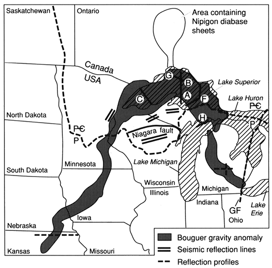
The anomaly pattern broadens within the Lake Superior basin and the regional trend changes from NE-SW to NW-SE as it continues into Michigan. The MCR in southeastern Michigan intersects the Grenville Front Tectonic Zone (GFTZ)--a zone which separates high-grade metamorphic rocks of the Grenville Province from older adjacent provinces to the west--a result of the continent-continent collision of the 1.3-1.0 Ga Grenville Orogeny (Moore, 1986). The coincident age of the MCR and GFTZ coupled with the late-stage reverse movement of MCR faults has led to speculation that the rifting event terminated with the Grenville Orogeny.
On the Bouguer gravity map of the northeastern Kansas area (fig. 2), the most notable feature is the anomaly caused by the MCR. The feature extends from the northeast comer of the map (central Iowa) into southeastern Nebraska, where it is offset by about 60 km (37.3 mi), and then continues into Kansas. The basement surface lithology in the area between the rift segments in Nebraska and Kansas is predominantly a plutonic terrane of pre-Keweenawan granite gneiss and schist. The prominence of cataclastic rocks in southeastern Nebraska has led to the speculation of a crustal break in this area (Muehlberger et al., 1967), but because of the uncertain trend in the cataclasis, its association with the offset in the anomaly is conjectural (Lidiak, 1972).
Figure 2--Kansas line 1 and Texaco Poersch #1 borehole (dot).
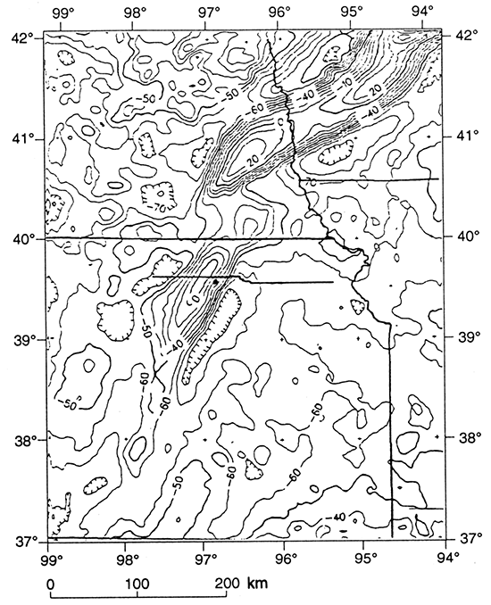
The Iowa-Nebraska segment of the gravity anomaly is generally greater in magnitude and characterized by steeper gradients than those of the Kansas segment. In Kansas, the gravity gradient of the anomaly is steeper on the east side of the peak, and although its magnitude decreases to the southwest, the linear trend of the anomaly can be seen to extend into southern Kansas. In general, the gravity values to the east of the MCR in this area are lower than those to the west by about 10 mGal. This shift in the Bouguer gravity is observed as a broad positive gradient to the west in the high-cut (wavelengths greater than 8°) free-air gravity anomaly map of North America (von Frese et al., 1982) and other published anomaly maps (Simpson et al., 1986). Woelk (1989) accounts for the 10-mGal shift in modeling of the rift by a variation in the density of the upper crustal layer, whereas Lam (1986) indicates that the anomaly is related to crustal thickness variations and Simpson et al. (1986) suggest a possible correlation to a Precambrian suture along which the rift developed. However, mapping of the basement rocks by isotopic dating and lithology (Van Schmus et al., 1987) has failed to give evidence of a suture in the basement rocks predating the rifting event.
The magnetic anomaly map (fig. 3) is more complex than the gravity with many prominent anomalies. The MCR magnetic anomaly is not as smoothly varying as its gravity anomaly. In the Iowa-Nebraska segment, magnetic lows are present over the axis of the anomaly and the Kansas segment is of greater magnitude than that of the Iowa-Nebraska segment. The lows over the axial highs are probably caused by the remnants of the clastic-basin fill that originally blanketed the volcanic-filled troughs (King and Zietz, 1971).
Figure 3--Total intensity magnetic anomaly map of study area with location of COCORP Kansas line 1 and Texaco Poersch #1 Borehole (dot).
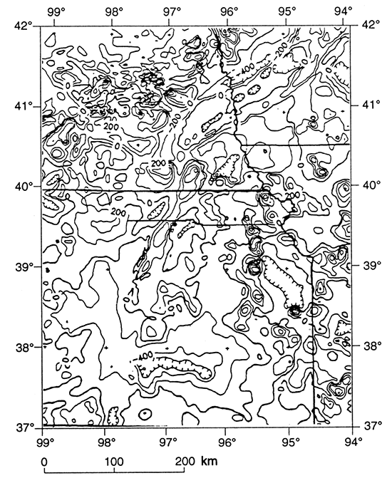
The MCR magnetic anomaly terminates in central Kansas against a roughly linear trend of negative anomalies. The most prominent of these anomalies is the intense magnetic minimum in southern Kansas known as the Wichita Magnetic Low. Having no correlative gravity anomaly, this magnetic anomaly has been interpreted to occur along a east-west-trending Proterozoic suture zone (Yarger, 1981) with the Wichita Magnetic Low being a result of the contrast between two crustal blocks and large granitic plutons (Meyer, 1987). The series of roughly circular anomalies extending from northeastern Kansas into east-central Kansas are considered to be granitic plutons, possibly intruded along a zone of weakness that later influenced formation of the Forest City basin (Yarger, 1985).
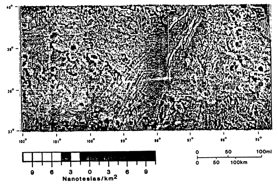
Figure 4 is a second vertical derivative magnetic map of Kansas (after Yarger, 1985). The magnetic quiet zone that surrounds the magnetic high of the MCR corresponds to the proposed limit of a basin filled with Keweenawan clastic rocks (Yarger, 1985). Yarger (1985) has interpreted the lineations extending southwest from the quiet zone to correspond to block faulting and possibly to mafic dike intrusions that occurred during rifting. These lineations occur over an area of about 100 km (62 mi) in width, implying an extensive area of sub-rift crustal disturbance. This map also provides strong evidence for the continuation of the MCR south to at least the Kansas-Oklahoma border.
Figure 4--Second vertical derivative of reduced-to-the-pole total intensity magnetic anomaly map of Kansas (after Yarger, 1985).
The igneous and clastic rocks associated with the MCR are exposed in the Lake Superior region and comprise the Keweenawan Supergroup. The Keweenawan Supergroup can be divided into two major suites: an igneous-sedimentary unit that occurs as primary basin fill, and a later sedimentary unit that occurs as late-stage fill of basins overlying the initial rock suite (Van Schmus and Hinze, 1985). Figure 5 shows the stratigraphic terminology and the time relationships along the MCR from Lake Superior to Kansas.
Figure 5--Stratigraphic terminology and the time relationships along Midcontinent rift trend (after Dickas, 1986).
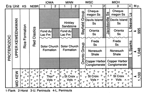
The Keweenawan volcanic rocks are composed of abundant olivine tholeiite, transitional basalts, basaltic andesites, rhyolites, and a few icelandites deposited into individual basins separated in space and perhaps time as the intensity and character of rifting fluctuated (Green, 1982). As a result of the time and space fluctuation of eruptions, individual flow units locally thicken and thin (Van Schmus and Hinze, 1985), but individual flow units have been traced over a distance of up to 90 km (56 mi) along strike. Thicknesses range from 1 m to 100 m (3.3 ft to 328 ft) with an average thickness of 10-30 m (33-98 ft) (Green, 1983).
The interflow sedimentary rocks make up approximately only 3% of the primary rift basin fill, They have been described as coarse, immature, polymictic, red-bed clastic rocks interbedded within the Keweenawan lava pile (Merk and Jirsa, 1982). The interflow rocks were derived from three sources: subjacent lava flows; distant, uplifted Keweenawan volcanic and intrusive rocks; and pre-Keweenawan rocks adjoining the rift. Deposition was by streams flowing over the surfaces of the volcanic flows during short periods of volcanic quiescence (Van Schmus and Hinze, 1985).
The intrusive Keweenawan rocks of this unit are composed of dike swarms, diabase sills, small plutons, large cumulate bodies, and alkaline complexes. While the relationship of the alkaline complexes to the rift is not clear, the large gabbroic bodies and basaltic sills and dikes are intimately associated with the Keweenawan volcanics (Van Schmus and Hinze, 1985).
The post-volcanic sedimentary rocks comprise the upper Keweenawan. They postdate active rifting, most likely being deposited in basins originating by vertical tectonic processes, such as broad crustal subsidence due to the excess mass of the volcanics (Van Schmus and Hinze, 1985) and thermal subsidence. In Kansas, these post-volcanic sedimentary rocks are called the "Rice Formation" (Scott, 1966 ; Berendsen et al., 1988).
Lithologically, the Rice Formation is predominantly an arkose or feldspathic sandstone with secondary amounts of micaceous and arenaceous green and red shale. Grains are rounded to subangular, frosted, and generally well sorted (Dickas, 1986; Berendsen et al., 1988). The Rice Formation contains limestone and dolomite interbedded with the sandstones and shales, suggesting marine or lacustrine influences (Scott, 1966; Berendsen et al., 1988).
The Texaco Poersch #1 borehole was drilled to a depth of 3,444 m (11,300 ft), making it the deepest borehole in Kansas and currently the second deepest penetration of the MCR after the Amoco 1 M. G. Eischeid borehole in Carroll County, Iowa (Berendsen et al., 1988; Anderson, 1990).
The Precambrian basement in the Poersch #1 borehole was encountered at 867 m (2,846 ft). The rocks from 867 m (2,845 ft) to total depth can be roughly divided into two distinct parts, or successions, of almost equal thickness (Berendsen et al., 1988) (fig. 6). The upper succession is dominated by mafic volcanic rocks and subordinate mafic and acidic intrusives, and the lower succession is dominated by arkose and subarkose with minor amounts of siltstone and shale (Berendsen et al., 1988).
Figure 6--Lithologic log of Texaco Poersch #1 Borehole (after Berendsen et al., 1988).
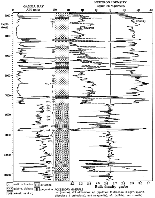
The top of the upper, volcanic-dominated, succession is marked by a 88-m (288-ft)-thick gabbro unit that is in sharp contact with the overlying Phanerozoic rocks. Underlying the gabbro, the upper succession is composed of a 300-m (984-ft)-thick sequence of basalt flows, a 480-m (1,575-ft)-thick mixed volcanic-sedimentary sequence which is followed by a 400-m (1,312 ft)-thick sequence of basalt flows and another mixed package 120 m (394 ft) thick. Basalt flow tops were identifiable in all sequences from a reddish color of the rock which can be attributed to oxidation of the top of the flow (Berendsen et al., 1988). The sedimentary packages in the mixed sequences fine upward. Several pegmatites occur in this upper unit. They may all be related to the same intrusive event (Berendsen et al., 1988).
At a depth of 2,265 m (7,429 ft), the lower sedimentary-dominated succession was encountered. This unit can be divided into three sequences bounded by relatively thin mafic volcanic flows or intrusives (Berendsen et al., 1988). The upper sequence consists of about a dozen distinct sedimentary packages that can be characterized by fining upward (Berendsen et al., 1988). Sedimentary rocks in the middle sequence resemble the rocks of the upper sequence, but are consistently coarser grained (Berendsen et al., 1988). Grains of volcanic rock are more common in the lower sedimentary sequence and increase in abundance downward, possibly indicating the presence of flows slightly below the total depth of the hole (Berendsen et al, 1988).
The sedimentary and igneous rocks encountered in the Poersch borehole are decidedly synrift deposits (Berendsen et al., 1988). However, the order of their encounter in the borehole is opposite of what would be expected from the Lake Superior region stratigraphy. This suggests that the MCR in Kansas has been subject to the same late-stage reverse movement observed for northern segments of the rift.
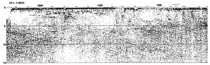
Between 1979 and 1981, COCORP recorded 317 km (197 mi) of deep seismic reflection profiles in northern Kansas. The principal purpose of this survey was to investigate the Midcontinent rift. The details of this 15-sec two-way travel time (TWT) reflection survey were provided by Brown et al. (1983) and Serpa et al. (1984).
Line 1 which images the MCR is shown in fig. 7. The upper 0.5 sec consist of relatively continuous and flat-lying reflectors that correspond to the Paleozoic section of the Forest City and Salina basins. These basins were part of the ancestral North Kansas basin and are now separated by the Nemaha Ridge (centered near vp (vibrating point) 1000). The Nemaha Ridge is bounded to the east by the Humboldt fault zone (near vp 900). By far the most prominent feature on the seismic profile is the MCR. Situated between vps 1400 and 2100, the MCR is characterized by high-amplitude reflections extending to about 4 sec which represent the Keweenawan synrift package. These reflections are believed to originate from seismic impedance contrasts between the volcanic and interflow sedimentary units or physical property contrasts within and between the volcanic flows. Above 5 sec relatively few reflections occur except for those from the MCR. This suggests that the upper crust in this area is primarily granitic terrane as supported by drill-hole data. Numerous strong, coherent reflections and diffractions occur below 5 sec. Brown et al. (1983) have suggested that these middle and lower crustal reflections are due to complex, three-dimensional fold and intrusion structures. These deep events are fewer in number and are less continuous under the main axial basin of the rift. This change in seismic character may be due to structural disturbance and igneous intrusion or it may be an artifact of reduced penetration through the axial basin. Moho reflections, expected at TWT of 11 to 13 sec are seemingly absent; however, the decrease in the number of reflections below 12 sec may represent a transition from crust to mantle. Although the Moho does not produce strong reflections, the reflections below 10 sec convey a sense of downwarp toward the center of the crust beneath the rift, suggesting thickening of the crust.
Figure 7--COCORP Kansas seismic reflection line 1.
Interpretation of the upper rift structure was carried out using a reprocessed version of the upper 4 sec of line 1, used by Texaco, U.S.A. in their investigation of the rift (Berendsen et al., 1988; Woelk, 1989) In the reprocessed version, the reflectors from the axial basin are more coherent than in the original line, resulting in a more interpretable time section. Figure 8 shows the seismic interpretation superimposed on a line drawing of the reprocessed section; potential-field anomalies and lithologies from nearby basement drill hole are projected onto the section to provide additional control,
Figure 8--Interpreted stick diagram of reprocessed COCORP Kansas line 1 with bouguer gravity and total intensity magnetic profiles plotted. Location of nearby drill holes are projected along geologic strike.
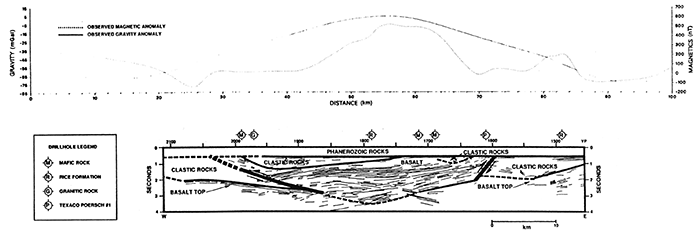
The western limit of the basalt basin is interpreted to be a reverse fault. This suggests that the dipping reflector package beneath vp 2000 images a ramp zone above a reverse fault. This arrangement is strikingly similar to what has been interpreted for seismic profiles across the MCR in Iowa, Wisconsin, and Minnesota (Chandler et al., 1989; Hinze et al., 1990). Thrusting of the basalt to its indicated position below the Phanerozoic cover is implied by both a magnetic high over vp 2000 and a correlative anomaly in the Bouguer gravity a short distance to the west. The offset between the gravity and magnetic highs may be attributed to the remanent magnetization of the basalts. Of the four boreholes that penetrated the basement along the trend of this ramp, three encountered mafic rocks while a fourth reported encountering granitic rock. The presence of granitic rock along this trend is problematic, but the predominance of mafic rocks along the trend, coupled with the potential-field anomalies, support the presented interpretation. The reflectors west of this fault are interpreted to be basalt. The depth extent of this unit is not clearly delineated; therefore, potential-field modeling was used to make this determination.
Moving easterly over the basin, a cross-cutting event can be seen between vps 1700 and 1750 at about 3 sec. Inspection of this event shows that reflectors on both sides of the event are clearly defined, and although the reflectors are clearly interrupted, they appear to correlate across the event without offset. This event is interpreted to be a result of seismic triplication (bow-tie) caused by basin geometry and not by geological structure. Serpa et al. (1984) noted that time migration did not resolve this cross-cutting relationship. However, this does not preclude the possibility of this event being a bowtie because time migration does not produce a true subsurface picture when the lateral velocity gradient is significant, as is the case with rifts. The resulting interpretation of the axial basin clearly resembles the structure and geometry that has been attributed to the MCR in previous investigations in Michigan (Brown et al., 1982; Fox, 1988), Lake Superior (Cannon et al., 1989), Iowa, Wisconsin, and Minnesota (Chandler et al., 1989). Individual volcanic units are traceable within the trough and appear to thicken toward the center of the basin, indicating that the rift basin was subsiding as it was being filled with synrift deposits. The bottom of the basin is difficult to determine in the seismic line. Further complicating the matter is the possibility that there is a lower unit of relatively homogeneous, less-reflective Keweenawan basalts, as observed elsewhere along the rift (Halls, 1978; Zhu and Brown, 1986; Chandler et al., 1989; Hinze et al., 1990).
One of the most interesting changes that is evident in the reprocessed line occurs east of vp 1650. The reflectors from the main basin are seen to be rising toward the structural high drilled by Texaco but are interrupted by a series of west-dipping reflectors at vp 1600. A change in the nature of the reflectors on either side of this west-dipping event also occurs; those to the east appear broken and disjointed in contrast to the continuity of the reflectors to the west. The series of west-dipping reflectors at vp 1600 are interpreted as a reverse fault. Projection of the Poersch borehole along strike suggests that the hole drilled through a reverse fault, thus providing an explanation for the transposed order of the dominant rock types from that observed elsewhere in the rift. The fault was not recognized in the log prepared from the drill-hole rock cuttings or in the wireline logs (Berendsen et al., 1988), but its presence is supported by a small magnetic high between vps 1550 and 1600 that has continuity along the strike of the rift. The offset between the magnetic high and the fault is probably due to the remanent magnetization of the basalt, but may also be influenced by the extent of the gabbroic intrusive that was encountered in the Poersch hole directly below the Phanerozoic rocks. This interpretation suggests that the curved reflections observed just below the fault plane are a result of impedance contrasts between the thin basalt flows and the large sedimentary packages encountered in the bottom half of the Poersch borehole.
Structural interpretation east of vp 1600 is difficult due to the lack of coherent reflectors. With the interpretation of a reverse fault beneath vp 1600, it is assumed that Keweenawan basalt is present at depth, below the synrift sedimentary rocks. This is supported by the increasing amount of volcanic rock grains noted at the bottom of the Poersch borehole. The magnitude and gradient of the gravity anomaly also suggest that high-density material is present below the bottom of the borehole and continuing east. Therefore, the top of a basalt body is interpreted to occur below the borehole and continuing east to the package of reflectors noted beneath vp 1500. The termination of the basalt body at this point is supported by the magnetic high between vps 1450 and 1500. Somanas and others (1989) proposed that this magnetic high was caused by an intrusive body apart from the rift rather than a thin edge. However, the corresponding gravity anomaly at this point reflects only a change in gradient rather than a high, suggesting that the basalt terminates at this point as previously modeled by Yarger (1980; in Hahn, 1980).
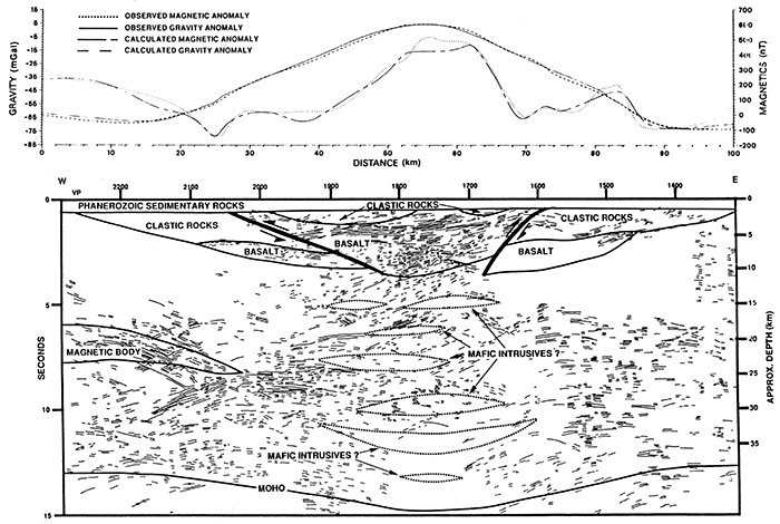
To further refine the interpretation initiated with the seismic-reflection profile, gravity and magnetic anomaly profiles were modeled along the COCORP line. It is possible to duplicate the observed gravity anomaly with bodies only in the upper 12 km of the crust using a geologic model similar to that shown in fig. 8. This model implies either that the outpouring of basalts occurred from a rather thin conduit leaving most of the crust undisturbed or that lower crustal intrusive bodies have negligible density contrast with the adjacent crust. However, a model incorporating the concept that the entire crust was disturbed by the rifting event also matches the observed anomaly as shown in fig. 9. Only the anomalous magnetic body at 6-7 sec was added to the gravity model to match the western margin of the magnetic profile. This model has the rift basin reaching a maximum depth of 9 km rather than 11.5 km where only the upper crust is involved. The throw on the reverse faults on either side of the rift basin is 3 km.
The model shown in fig. 9 is the preferred interpretation because it incorporates not only the gravity and magnetic modeling, but also the results of the seismic-reflection profiling and rock types encountered in the Poersch drill hole. Of special note is the regional thickening of the crust as suggested by the general downbowing of the deep seismic reflections. This model incorporates the concept that the entire crust is disturbed and intruded by dike swarms and igneous plutons, and although the crust is initially thinned, the crust is ultimately thickened by isostatic sinking. The magnetic modeling does not contribute to the lower crustal interpretation because most of the modeled magnetic anomaly is caused by bodies located within the upper 10 km of the crust. The crustal structure of this model is strikingly similar to the models proposed for the northern segments of the rift (e.g., Cannon et al., 1989; Hinze et al., 1992), arguing that there is homogeneity in structural style along the length of the rift. This conclusion is compatible with the recent U-Pb dating of the gabbro of the Texaco Poersch #1 hole (Van Schmus et al., 1990) that places the age of this intrusion (1,097.5 ± 3 Ma) in the middle of published U-Pb ages (1,086-1,108 Ma) for the Midcontinent rift igneous rocks in the Lake Superior region.
Figure 9--Geologic model of stick diagram of COCORP Kansas line 1 with calculated and observed Bouguer gravity anomaly and total intensity magnetic anomaly.
The recently published data from Texaco, U.S.A.'s investigation of the MCR in northeastern Kansas have provided valuable information on the structural nature of the rift. Lithologic logs from the Texaco Poersch #1 borehole show that a transposed Keweenawan stratigraphy of gabbro and basalt overlying clastic rocks is present on the east side of the rift in Kansas in contrast to the rock sequence observed elsewhere in the MCR. This information, along with the density and velocity logs, provide constraints not available to previous interpretations of the seismic reflection and potential-field data. A reprocessed version of the upper 4 sec of COCORP seismic reflection Kansas Line 1 generated by Texaco, U.S.A. clearly images the axial trough of the MCR. This seismic line is interpreted to image the axial rift basin bounded by reverse faults. Projection of the Poersch #1 borehole along strike shows that Texaco, U.S.A. drilled through the eastern-bounding reverse fault accounting for the transposed order of lithology encountered in the borehole. Potential-field modeling supports the seismic interpretation of the rift structure. The resulting model of an axial rift basin bound by reverse faults is strikingly similar to interpretations proposed for northern segments of the rift, arguing that there is consistency in the structural style and tectonic evolution along the length of the rift system.
Supported in part by National Science Foundation Grant EAR-8617315. We thank the Kansas Geological Survey (KGS) and Texaco USA for providing data used in this study. We also thank Don Steeples (The University of Kansas) and Pieter Berendsen (KGS) and Roger Borcherding (Texaco USA) for their assistance, and Lawrence W. Braile (Purdue University) for his advice on interpreting the seismic sections.
Anderson, R. R., 1990, Interpretations of geophysical data over the Midcontinent Rift System in the area of the M. G. Eischeid #1 petroleum test, Carroll County, Iowa; in, The Amoco M.G. Eischeid #1 deep petroleum test, Carroll County, Iowa, R R. Anderson, ed.: Iowa Department of Natural Resources, Special Report Series, no. 2, p. 27-38
Behrendt, J. C., Green, A. G., Cannon, W. E, Hutchinson, D. R., Lee, M., Milkereit, B., Agena, W. E, and Spencer, C., 1988, Crustal structure and deep rift basin of the Midcontinent Rift System--results from GLIMPCE deep seismic reflection profile: Geology, v. 16, p. 81-85
Berendsen, P., Borcherding, R. M., Doveton, J., Gerhard, L., Newell, K. D., Steeples, D., and Watney, W. L., 1988, Texaco Poersch #1; Washington County, Kansas--Preliminary geologic report of the pre-Phanerozoic rocks: Kansas Geological Survey, Open-file Report 88-22, 116 p. [available online]
Brown, L., Jenson, L., Oliver, J., Kaufman, S., and Steiner, D., 1982, Rift structure beneath the Michigan basin from COCORP profiling: Geology, v. 10, p. 645-649
Brown, L., Serpa, L., Setzer, T., Oliver, J., Kaufamn, S., Lillie, R, Steiner, D., and Steeples, D. W., 1983, Intracrustal complexity in the United States midcontinent--Preliminary results from COCORP surveys in northeastern Kansas: Geology, v. 11, p. 25-30
Cannon, W. E, Green, A. G., Hutchinson, D. R, Lee, M., Milkereit, B., Behrendt, J. C., Halls, H. C., Green, J. C., Dickas, A. B., Morey, G. B., Sutcliffe, R, and Spencer, C., 1989, The Midcontinent rift beneath Lake Superior from GLIMPCE seismic-reflection profiling: Tectonics, v. 8, p. 305-332
Chandler, V. W., McSwiggen, P. L., Morey, G. B., Hinze, W. J., and Anderson, R. R., 1989, Interpretation of seismic reflection, gravity, and magnetic data across the Middle Proterozoic Midcontinent rift system, northwestern Wisconsin, eastern Minnesota, and central Iowa: American Association of Petroleum Geologists, Bulletin, v. 73, p. 261-275
Chase, C. G., and Gilmer, T. H., 1973, Precambrian plate tectonics--the Midcontinent gravity high: Earth and Planetary Sciences, Letters, v. 21, p. 70-78
Dickas, A. B., 1986, Comparative Precambrian stratigraphy and structure along the Midcontinent rift: American Association of Petroleum Geologists, Bulletin, v. 70, p. 225-238
Fox, A. J., 1988, An integrated geophysical study of the southeastern extension of the Midcontinent rift system: M. S. thesis, Purdue University, 112 p.
Green, J. C., 1982, Geology of Keweenawan extrusive rocks; in, Geology and Tectonics of the Lake Superior Basin, R. J. Wold and W. J. Hinze, eds.: Geological Society of America, Memoir 156, p. 239-243
Green, J. C., 1983, Geologic and geochemical evidence for the nature and development of the Middle Proterozoic (Keweenawan) Midcontinent rift of North America; in, Processes of Continental Rifting, P. Morgan and B. H. Baker, eds.: Tectonophysics, v. 94, p. 413-437
Hahn, R. K., 1980, Upper mantle velocity structure in eastern Kansas from teleseismic p-wave residuals: M. S. thesis, University of Kansas, 84 p.; also available as Kansas Geological Survey, Open-file Report 80-14
Halls, H. C., 1978, The Late Precambrian central North American rift system--a survey of recent geological and geophysical investigations; in, Tectonics and Geophysics of Continental Rifts, I. B. Ramberg and E. R. Neumann, eds.: NATO Advanced Study Institute, v. 37, p. 111-123
Hinze, W. J., 1963, Regional gravity and magnetic anomaly maps of the Southern Peninsula of Michigan: Michigan Geological Survey, Report of Investigations, no. 1, 26 p.
Hinze, W. J., Kellogg, R L., and O'Hara, N. W., 1975, Geophysical studies of basement geology of the Southern Peninsula of Michigan: American Association of Petroleum Geologists, Bulletin, v. 59, p. 1,562-1,584
Hinze, W. J., Wold, R. J., and O'Hara, N. W., 1982, Gravity and magnetic anomaly studies of Lake Superior; in, Geology and Tectonics of the Lake Superior Basin, R. J. Wold and W. J. Hinze, eds.: Geological Society of America, Memoir 156, p. 203-222
Hinze, W. J., and Braile, L. W., 1988, Geophysical aspects of the craton--U. S.; in, Sedimentary Cover--North American Craton, L. L. Sloss, ed.: Geological Society of America, The Geology of North America, D-2, p. 5-24
Hinze, W. J., Braile, L. W., and Chandler, V. W., 1990, A geophysical profile of the southern margin of the Midcontinent rift system in western Lake Superior: Tectonics, v. 9, p. 303-310
Hinze, W. J., Allen, D. J., Fox, A. J., Sunwood, D., Woelk, T. S., and Green, A. G., 1992, Geophysical investigations and crustal structures of the North American midcontinent rift system, Part C; in, Geodynamics of Rifting, P. Ziegler, ed.: Tectonophysics, v. 213, no. 1-2, p. 17-32
King, E. R, and Zietz, I., 1971, Aeromagnetic study of the Midcontinent gravity high of central United States: Geological Society of America, Bulletin, v. 82, p. 2,187-2,208
Klasner, J. S., Wold, R. J., Hinze, W. J., Bacon, L. O., O'Hara, N. W., and Berkson, J. M., 1979, Bouguer gravity anomaly map of the northern Michigan-Lake Superior region: U.S. Geological Survey, Geophysical Investigation Map GP-930, scale 1:1,000,000 [available online]
Lam, C. K., 1986, Interpretation of statewide gravity survey of Kansas: Ph.D. thesis, University of Kansas, 213 p.
Lidiak, E. G., 1972, Precambrian rocks in the subsurface of Nebraska: Nebraska Geological Survey, Bulletin, no. 26, 41 p.
Lidiak, E. G., and Hinze, W. J., 1993, Grenville province in the subsurface of eastern United States; in, Precambrian--Conterminous U.S., J. C. Reed et al., ed.: Geological Society of America, The Decade of North American Geology (DNAG), v. C-2, p. 353-365
Lyons, P. L., 1959, The Greenleaf anomaly, a significant gravity feature; in, Symposium of the Geophysics of Kansas, W. W. Hambleton, ed.: Kansas Geological Survey, Bulletin 137, p. 105-120 [available online]
Merk, G. P., and Jirsa, M. A., 1982, Provenance and tectonic significance of the Keweenawan interflow sedimentary rocks; in, Geology and Tectonics of the Lake Superior Basin, R. J. Wold and W. J. Hinze, eds: Geological Society of America, Memoir 156, p. 97-105
Meyer, W. V., 1987, The Wichita magnetic low, southeastern Kansas: M.S. thesis, Purdue University, 95 p.
Moore, J. M., 1986, Introduction--the "Greville Province" then and now; in, The Grenville Province, J. M. Moore, A. Davidson, and A. J. Baer, eds.: Geological Association of Canada, Special Paper 31, p. 1-11
Morey, G. B., and Green, J. C., 1982, Status of the Keweenawan as a stratigraphic unit in the Lake Superior region; in, Geology and Tectonics of the Lake Superior Basin, R. J. Wold and W. J. Hinze, eds.: Geological Society of America, Memoir 156, p. 15-25
Muehlberger, W. R., Denison, R. E., and Lidiak, E. G., 1967, Basement rocks in continental interior of United States: American Association of Petroleum Geologists, Bulletin 51, p. 2,351-2,380
Oray, E., Hinze, W. J., and O'Hara, N. W., 1973, Gravity and magnetic evidence for the eastern termination of the Lake Superior syncline: Geological Society of America, Bulletin 84, p. 2,763-2,780
Scott, R. W., 1966, New Precambrian(?) formation in Kansas: American Association of Petroleum Geologists, Bulletin 50, p. 380-384
Serpa, L., Setzer, T., Farmer, H., Brown, L., Oliver, J., Kaufman, S., Sharp, J., and Steeples, D. W., 1984, Structure of the southern Keweenawan rift from COCORP surveys across the Midcontinent geophysical anomaly in northeastern Kansas: Tectonics, v. 3, p. 367-384
Simpson, R. W., Jachens, R. C., and Blakely, R. J., 1986, A new isostatic residual map of the conterminous United States with a discussion on the significance of isostatic residual anomalies: Journal of Geophysical Research, v. 91, p. 8,348-8,372
Somanas, C., Knapp, R. W., Yarger, H. L., and Steeples, D. W., 1989, Geophysical model of the midcontinent geophysical anomaly in northeastern Kansas; in, Geophysics in Kansas, D. W. Steeples, ed.: Kansas Geological Survey, Bulletin 226, p. 215-228 [available online]
Thiel, E. C., 1956, Correlation of gravity anomalies with Keweenawan geology of Wisconsin and Minnesota: Geological Society of America, Bulletin 67, p. 1,079-1,100
Van Schmus, W. R., and Hinze, W. J., 1985, The Midcontinent Rift System: Annual Review of Earth and Planetary Sciences, v. 13, p. 345-383
Van Schmus, W. R., Bickford, M. E., and Zietz, I.,1987, Early and Middle Proterozoic provinces in the central United States; in, Proterozoic Lithospheric Evolution, A. Kroner, ed.: American Geophysical Union, Geodynamic Series, v. 17, p. 43-68
Van Schmus, W. R., Martin, W. D., Sprowl, D. R., Geissman, J., and Berendsen, P., 1990, Age, Nd and Pb isotopic composition, and magnetic polarity for subsurface samples of the 1100 Ma Midcontinent rift: Geologic Society of America, Abstracts with Programs, v. 22, no. 7, p. AI74
von Frese, R. R. B., Hinze, W. J., and Braile, L. W., 1982, Regional North American gravity and magnetic anomaly correlations: Geophysical Journal of Research, Astronomical Society,v. 69, p. 745-761
Woelk, T. S., 1989, An integrated geophysical study of the Midcontinent Rift System in northeastern Kansas: M.S. thesis, Purdue University, 74 p.
Woelk, T. S., and Hinze, W. J., 1991, Model of the Midcontinent Rift System in northeastern Kansas: Geology, v. 19, p. 277-280
Woollard, G. P., 1943, Transcontinental gravitational and magnetic profile of North America and its relation to geologic structure: Geological Society of America, Bulletin 54, p. 747-790
Yarger, H. L., 1981, Aeromagnetic survey of Kansas: EOS, American Geophysical Union, Transactions, v. 62, no. 17, p. 173-178
Yarger, H. L., 1985, Kansas basement study using spectrally filtered aeromagnetic data; in, The Utility of Regional Gravity and Magnetic Anomaly Maps, W. J. Hinze, ed.: Society of Exploration Geophysicists, p. 213-232
Zhu, T., and Brown, L. D., 1986, Consortium for Continental Reflection Profiling Michigan Survey-reprocessing and results: Journal of Geophysical Research, v. 91, p. 11,477-11,495
Previous--Geophysical Model from Potential-field Data || Next--Forward Seismic Modeling
Kansas Geological Survey
Comments to webadmin@kgs.ku.edu
Web version placed online Aug. 19, 2015. Original publication date 1995.
URL=http://www.kgs.ku.edu/Publications/Bulletins/237/Woelk1/index.html