![]()
Prev Page--Finally Persuaded || Next Page--From Haworth to Moore
|
|
Prev Page--Finally Persuaded || Next Page--From Haworth to Moore | |
|
Start
Starting Over
|
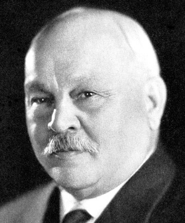
6. Almost like starting over: the University Geological Survey, 1889-1907For 23 years, from 1866 to 1889, the state of Kansas was without a formal geological survey. In some respects, the gap was filled by the work of other state agencies and state universities. But for the most part, the state had no entity whose single concern was geology, even though those years were some of the most exciting, geologically speaking, in the history of the state. The Survey's establishment at the University of Kansas in 1889 changed that. Not overnight, but slowly, the survey began to evolve within the University, a development that was characterized by fits and starts, trials and errors, periods of little activity and times of scientific excitement and accomplishment.In some respects, the Survey's development mirrored that of the University and the state as a whole. For Kansas, the tail end of the 19th century was a time of economic and political turmoil, filled with good times and bad. Nearly all of western Kansas was settled by the 1880s, though that end of the state endured economic ups and downs, grasshopper plagues, and bad weather (Miner, 1986). An economic depression that began in 1893 sent another shock wave through the state's economy and forced the departure of many of the settlers from the western part of the state. The setback was generally temporary, and presently the economic climate improved. At the same time the state was alive with the political activity of the Populist Party. Kansas was among the first states to introduce many of the reforms of the Populists, and their proposals generally produced a tempest of politics. The Survey was more directly affected by the fortunes of the University of Kansas. In 1889, the University was on the verge of a major shift in its own evolution as an educational institution. Francis Snow, a professor of natural history, was about to take over as chancellor. The University was contemplating offering a Ph.D., and before the end of the century it would divide itself into several colleges, behavior more characteristic of a university (Griffin, 1974). Yet the University of Kansas was still a handful of buildings atop a windswept hill that was grandiloquently called Mount Oread. It was still only a few hundred students learning in college departments of uneven quality. And it was still a university that suffered mightily according to the whims of the Kansas legislature. When times were hard the University suffered along with, and sometimes even more than, the rest of the state. Haworth's first yearsThe Survey, then, joined the maturation process of the University. The guiding light in those early years was, without a doubt, Erasmus Haworth. Haworth was born in Warren County, Iowa, and his family moved to Galena, Kansas, when he was 11 (Moore, 1933a, 1933b). Haworth earned an undergraduate degree from KU in 1881. He added a Ph.D. from Johns Hopkins in 1889, taught at Penn College in Oskaloosa, Iowa, until 1892, and then was brought to Kansas in 1892, probably by Chancellor Snow, who believed strongly that the University should provide services, along with education, to the state. Haworth was already familiar with the state's geology when he returned to Kansas. In the early 1880s, he published several articles on Kansas geology in the Transactions of the Kansas Academy of Science (Haworth, 1883a, 1883b, 1883c) and his master's thesis was on the geology of the lead and zinc mining district of Cherokee County in southeastern Kansas (Haworth, 1884).
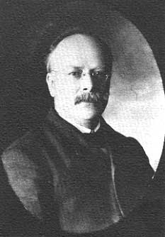
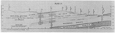
In his years at Kansas, Haworth was the consummate field geologist. He traveled throughout the state doing field work, and was well known by students and the state's residents alike. To his students he became known as "Daddy" Haworth, an acknowledgment that he had, in many respects, followed Benjamin Mudge as the grand old man of Kansas geology in the late 1800s and early 1900s (Griffin, 1974, p. 293). Pictures of Haworth over the years show that he assumed a lordly bearing. His face has a dark, regal look; he grew a mustache that placed him in his era. And finally, he grew more and more rotund, claiming a larger and larger stake in the realm of geology. Haworth did not stay at the Survey for life, however. In 1915, he left to become a consulting geologist with his son Henry, although he continued to head the University's geology department until 1920, when he left KU completely. From 1920 until 1931, he was known throughout the state for his activities in the oil and gas business, and he regularly consulted on and was involved with business activities related to geology. Before his death in 1932 in Wichita, Haworth's name was closely associated with the discovery of the El Dorado oil field in Butler County, the mapping of several surface features that led to the discovery of oil, the study of the Equus Beds aquifer in central Kansas, and several geologically related capital ventures that met with varying degrees of success (see Haworth Collection, University of Kansas Archives, Spencer Research Library, Lawrence, Kansas; hereafter referred to as KU Archives). In 1892, however, Haworth came to the University and joined two colleagues who would later be part of the formal operations of the Survey. Samuel W. Williston was a paleontologist and an associate professor of geology who came to the University in 1890, when Snow assumed duties as chancellor. Williston had earned an M.D. from Yale University and had studied paleontology with O. C. Marsh. When Haworth arrived, Williston was already familiar with the Cretaceous fossils of western Kansas, publishing on fossils from the chalk in Science and the Transactions of the Kansas Academy of Science. In 1892 he published an article on Kansas pterosaurs in the first issue of the Kansas University Quarterly (Williston, 1892), a scientific journal started by faculty to give them an outlet for publication on campus. Another faculty member who published an article in that first Kansas University Quarterly was Edgar Henry Summerfield Bailey, a chemistry professor who reported on Waconda Springs in Mitchell County (Bailey, 1892). Bailey had a Ph.D. in chemistry from Illinois Wesleyan University. These three men--Haworth, Williston, and Bailey--formed the nucleus of that first Survey. In spite of the lack of separate funding from the state or the University, Haworth organized field work that led to extensive publication in the second volume of the University Quarterly. Haworth, working with several students and other volunteers from throughout the state, published articles about the geology and topography of eastern Kansas, including some of the first detailed and accurate cross sections developed by Survey staff members (see, for example, Haworth, 1894). The Quarterly included sections along rivers--such as the Neosho, Cottonwood, and Verdigris--and along a railroad from Cherryvale to Lawrence and from Ottawa to Kansas City. The sections were depicted in fold-out illustrations and were scientifically significant because they contained the first published references to a number of formation names, including the Oread Limestone and the Lawrence Formation, making a permanent contribution to the stratigraphic nomenclature of Kansas. That volume of the Quarterly included a lengthy article about the surface gravels found throughout eastern Kansas--a scientific problem that has long perplexed Kansas geologists--and several paleontological articles by Williston, again based largely on work done in western Kansas. In short, Haworth appeared to lead a fairly significant scientific effort, done largely with students and volunteer help, and Williston continued to establish a base of knowledge in paleontology.
That base continued to expand with the next edition of the Quarterly. Williston published on paleontology while Haworth discussed the geology of the so-called Coal Measures of southeastern Kansas (Haworth, 1895a, 1895b), covering roughly the same area where the rocks are today termed Pennsylvanian. Perhaps more significantly, this volume included several new geological illustrations. Haworth was credited with a drawing of the drainage, dip, and escarpments of several major formations of eastern Kansas. That map was drawn in "semi-perspective," a sort of block diagram tipped partially on its side so that the dip of the major formations was visible, along with the locations of deep drill holes that provided evidence for Haworth's subsurface characterizations. Also in that edition of the Quarterly was a geologic map of the state by Williston. Drawn in black and white, it was the first such published geologic map by a current member of the Kansas Geological Survey. As such, it represented a distinct refinement of the geologic map since Mudge's days with the State Board of Agriculture in the 1870s. Williston divided the geology into eight stratigraphic units. The Subcarboniferous (today called the Mississippian) covered the southeastern tip of the state. The Permo-Carboniferous lumped together the Pennsylvanian and the Permian Flint Hills of eastern Kansas, with extra shading in those areas that were covered by glacial drift. Williston divided the Cretaceous into four smaller groups, probably because it was the geologic period that he knew best, and because its fossils allowed division with relative ease. Williston divided the Cretaceous into the Comanche, Dakota, Benton, and Niobrara formations, and labeled the Red Hills of south-central Kansas as belonging to the Triassic. Today the area is classified as Permian, but it caused problems for stratigraphers for years, primarily because of its lack of fossils; they placed it in the Permian, Triassic, Cretaceous, and finally back in the Permian again. The final unit, shown in areas roughly corresponding with today's ideas, was the Tertiary. The University Geological SurveyThe work of Haworth and Williston, in particular, set the stage for 1895, when, for the first time, the University more formally organized the Survey. That year, the KU Board of Regents officially declared the State Geological Survey organized and named the chancellor, then F.H. Snow, as ex officio director. The significance of this action goes far beyond the formalization of the Survey, for the arrangement of chancellor as ex officio director was not mandated by state statute at the time. It was probably instituted as an administrative mechanism for incorporating the Survey as part of the University. Such an arrangement may have made sense at the time, given that Snow was both an active scientist and had a reputation of concern for the University's role in state service. The arrangement outlived Snow, becoming part of the state statute in 1907, and surviving to the present as something of a peculiar anachronism (the arrangement was even influential outside of Kansas. At least one other state survey, the Texas Bureau of Economic Geology, may have patterned its organizational structure, in part, after Kansas as part of an attempt to introduce budgetary stability [Keith Young, 1988, personal communication]).With Snow as ex officio director, the Survey was organized into three separate divisions: Williston was head of the department of paleontology, Haworth head of the department of physical geology and mineralogy, and Bailey head of the department of chemistry. At the beginning, at least, there was no formal, recognized notion that Haworth was either state geologist or director of the Survey; rather the departments operated as three separate but equal units. Wrote Haworth, "It is contemplated by the Board of Regents that the interested departments in the University will severally be responsible, not only for the work accomplished under the departments, but for the degree of energy and zeal with which it is prosecuted. Each will therefore be expected to issue reports from time to time on the work done, reports covering greater or lesser subjects or natural divisions of the great science of geology" (Haworth, 1896, p. 6). It may be, in fact, that Snow was expected to direct the Survey in actuality as well as title. In other words, the role of ex officio director may actually have meant something, not been simply titular (this was certainly true later, when Haworth regularly corresponded with chancellors about day-to-day administrative details. See Frank Strong Collection, KU Archives). Along with Haworth, Williston, and Bailey, the Survey relied upon 10 to 20 volunteers, mostly students, to do field work. That field work was the basis for much of the earlier publication in the University Quarterly and would be equally important in Survey publications to come. "Few, if any, instances can be found in the annals of America where so many able men have contributed so much of their time to the material development of their state," wrote Haworth (Haworth, 1896, p. 4). Volume IThough the Survey now had at least three employees and a number of volunteers, Haworth was clearly the leader of the band. He supervised much of the field work done by students. He was also shown as the author of the Survey's first publication in its current incarnation. That report, which appeared in 1896, was titled simply The University Geological Survey of Kansas, vol. 1. While Haworth was shown as author, he was probably more nearly an editor; a number of the chapters of the book were written by other staff members. In particular, other staff provided descriptions of eight new cross sections, including those from Galena to Wellington, Baxter Springs to the Nebraska border, the Oklahoma border to Council Grove, the Missouri border to Yates Center, the Missouri border to Alma, Kansas City to McFarland, Coffeyville to Lawrence, and Atchison to Barnes. The volume included a long discussion of the stratigraphy and topography of the Mississippian and Pennsylvanian, along with shorter discussions of oil and gas, soils, and paleontology.The topics covered, however, were only as important as the format that Haworth used in presenting the information. First, he wrote in a semi-technical nature, attempting to keep the level of discussion accessible to non-scientists. "It should be remembered by the scientific reader," he wrote, "that these reports are intended primarily for the masses of the citizens of Kansas, and that therefore an elementary character must be preserved, not however, it is hoped, at the expense of scientific accuracy" (Haworth, 1896, p. 8). In other words, Haworth attempted to put the results of the Survey before the public rather than before scientific colleagues. More technical presentations continued to be published in scientific journals, but there was a stated, obvious recognition that the Survey was playing to a non-scientific audience. In some respects, that same recognition probably influenced the selection of subjects covered. The discussion of soils, oil and gas, and coal fields could be attributed directly to trying to satisfy a demand for information, while the other topics, such as paleontology of the coal measures, were considerably more esoteric.
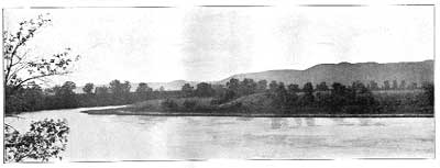
That first volume was distinguished, also, by its illustration. Like the articles in the Kansas University Quarterly, this volume included drawn cross sections that folded out from the book. It included drawn logs of several wells, and at least one topographic map showing contours, at 250-foot intervals, of the southern Flint Hills. More significant, however, were photographs, the first photographs in a Survey publication. The report included eight pictures, mostly of hills in southeastern Kansas and of river scenes. Though a relatively small number, the photographs were an added expense in the printing process and indicate an early concern about illustration. The book concluded with a fold-out geologic map done in semi-perspective, much in the same fashion as Williston's earlier map in the University Quarterly. It represents the first geologic map to appear in a Kansas Geological Survey publication.
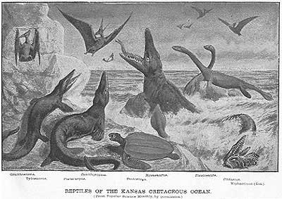
In short, volume I must have been, in its time, a handsome publication. It was hardbound, with the gold logo of the University Geological Survey of Kansas on the cover. It was substantial--320 pages long with accompanying cross sections, maps, figures, and photos. And it was scientifically important, not only because of the information it contained, but because it set a standard, a style, a pattern for further publication. The next nine volumes published by the Survey from 1897 to 1908 would all be in the same mode. Though the quality of illustration improved during that time, the overall appearance and scientific tone of those first books reflected the influence of the first volume. The second volume in that series appeared a year later (Haworth, 1897a). It was designed to act as a companion to the first volume, covering the western half of the state the way the earlier volume had covered the east. In general the tone and approach were much the same, though volume II, written almost entirely by Haworth, included 34 photographs, mostly landscapes, which were scattered throughout the book, rather than appended to the end as they had been in volume I. The second book also included virtually the same semi-perspective geologic map as was shown in volume I, along with two detailed geologic maps, one of the Red Hills and the other of the Equus Beds in south-central Kansas. Together, volumes I and II provided the most detailed, complete, and accurate set of information about Kansas geology yet compiled. From 1898 to 1908, the Survey produced seven more volumes. As opposed to general overviews of Kansas geology, these volumes were topical, concentrating on paleontology and subjects of economic interest--coal, gypsum, mineral waters, oil and gas, lead, and zinc. These volumes were important not only because they represented the formal product of the Survey, but because their topics and presentations showed the priority of geologic study within the state. They clearly showed where Survey scientists spent their time during those early years, and the level of presentation shows where the Survey decided to spend its appropriations. Because they symbolize much of the Survey's effort during those early years at the University, those volumes deserve further investigation. Volume III was about coal, written by Haworth and W. R. Crane, an assistant (Haworth, 1898a). Coal probably received priority because the state was still largely dependent on coal produced in southeastern Kansas, and production in the area was 3.8 million tons (more than three times the production level today) and increasing, particularly with the advent of underground mines. The volume on coal included an exhaustive discussion of the stratigraphy of the coal measures, along with a shorter discussion of coal-mining methods and diagrams and pictures of Kansas coal mines. Several of the maps were drawn with colored lines showing the outcrop of formations in eastern Kansas, representing the first time that color was used in a Survey publication, another step forward in the Survey's presentation of geologic information. In short, the volume on coal set a standard for publication on a topic of economic interest, and it was 42 years before the Survey felt the need to produce another comprehensive volume on the coal fields of southeastern Kansas. Clearly, Haworth's work stood time's test. The fourth volume (Williston, 1898) was the first to be credited to an author other than Erasmus Haworth. This first volume on paleontology was written by Samuel Williston, now head of a Survey department called Historical Geology and Paleontology. Williston concentrated on large vertebrate fossils from the Cretaceous, which is not surprising in light of the scientific importance of those finds and the interest that they conjured up within the state. Williston discussed fossil birds, fish, dinosaurs, crocodiles, and mosasaurs, along with shorter discussions of invertebrates and microscopic organisms from the Niobrara. Perhaps even more than the earlier volumes, volume IV set new standards for Survey publishing. More technical than the earlier volumes, volume IV was the most impressively illustrated of the lot. It included a number of photographs, but was especially distinguished by the delicate and exact line drawings, both of collected bone specimens and reconstructions. The frontispiece drawing of Cretaceous animals was widely reproduced. By 1898, Williston was recognized for his role in paleontology, and volume IV took its place as a classic in its field. In 1899, Williston was appointed dean of the KU School of Medicine. Before he left KU for the University of Chicago in 1902, Williston had made lasting contributions to knowledge of Kansas geology and paleontology and remains among the most famous of the scientists ever to work at the Survey.
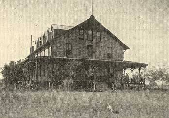
With the next volume (Grimsley and Bailey, 1899), the Survey returned to reporting on economic minerals. This time the subject was gypsum. By the 1890s, Kansas was one of the leading gypsum producers in the nation, primarily through mines operated in northeastern Kansas, near Blue Rapids, and in the Red Hills. The authors of this volume were E. H. S. Bailey, who continued as a chemist at the Survey, and G. P. Grimsley, who is listed as an assistant geologist and was apparently brought on board to produce the report on gypsum. In fact, Grimsley wrote the bulk of the report, with Bailey providing some of the chemical analyses. As with earlier volumes, the report on gypsum was lavishly illustrated with both figures and photographs, and was primarily aimed at a non-technical audience. The report, wrote the authors, was "as intensely practical as possible, believing that there is no necessary incompatibility between the strictly theoretic and scientific and the economic problems connected with the geology of any region" (Grimsley and Bailey, 1899, p. 11). Figures included a number of cross sections and diagrams of the mines. Along with the Kansas section, the book included separate discussions of the technology of gypsum mining and chemical analyses. The remainder of the volumes followed the same format. In volume VI (Williston, 1900), Williston returned to the subject of paleontology, although much of the book was written by graduate students. In volume VII (Bailey, 1902), Bailey wrote about the state's mineral-water springs and produced a remarkable little book that is filled with geochemical analyses of water and photographs of the bath-houses and hotels that sprang up around the springs in the late 1800s. Volume VIII (Haworth, Crane, Rogers, and others, 1904) was devoted to lead and zinc mining, and Volume IX (Haworth, 1908) was a special report on oil and gas, written largely by Haworth.
ChangesBy the time Haworth's book on oil and gas appeared, the Survey was a vastly different organization. In 1907, it underwent a statutory redefinition that gave the Survey new responsibilities and even a new name: the State Geological Survey of Kansas (Kansas Statutes Annotated 76-322,1984, vol. 6A, p. 468). That change is discussed in detail in the following chapter, but it represents the continuation of a trend of legislative direction for the Survey. By 1908, many of the personnel were different. Haworth, the only staff member remaining from the original 1895 Survey, was now shown as state geologist, legally required by the new statute, but he had been using the title on publications since 1903, obviously in recognition that, with the departure of S. W. Williston for Chicago in 1902, Haworth was indeed in charge.But the Survey was different not only because of its statutory responsibilities and personnel. During the late 1800s and early 1900s, the Survey began occupying something of a new niche as a quasi-state agency. That is, it concentrated less on reports about the state's basic geology (and even much of that emphasis had disappeared with the production of publications on "special topics" that were generally of economic interest, as opposed to the county-by-county geologic reports that were produced both before and after the University Geological Survey, and might logically have been expected to continue during this period). The University Geological Survey had begun, in 1897, to publish annual reports on mineral production in the state, including statistics about lead and zinc, coal, oil and gas, salt, gypsum, cement, building stone, and clay (see Haworth, 1898b, and following years). The reports were not strictly statistical, however. They included discussions of production techniques and photographs of mines and production sites. The Survey produced reports on the state's mineral resources for six years and that, combined with the nature of the bulletins produced during that period, provided evidence of the organization's redefinition. Under Haworth's influence, it became economically oriented. It concentrated more on service to the state's residents, perhaps as F.H. Snow had intended when Haworth came to Kansas. By 1907, the Survey's purpose, at least as reflected in its products, was less to study and report on the state's basic geology, and more to describe those minerals that were having an economic impact on the state. That shift in orientation may be responsible, at least in part, for the changes that came with the Survey's statutory redefinition in 1907. Before that time, the organization was the University Geological Survey, and the name was a true reflection of the organization. It had published in university serials; even after the Survey began producing its own publications, Haworth and Williston published regularly in the University Quarterly. Students and teaching faculty were the main source of personnel within the organization. The Survey was integrated within the University structure. But by the turn of the century, that was changing, and the Survey was beginning to take a broader look at the state, and its own role in providing information about geology. While the Survey remained at KU, and continued to be a part of the University, it was no longer the University Geological Survey. After 1907, it was the State Geological Survey. And the change, the transition, had come largely during Haworth's early years as de facto leader of the Survey. Haworth had changed the nature of the Survey dramatically and guided it to what it had become. Although he remained as director once the statutory revision was made, it was clear that he had laid the groundwork, set the stage for those changes, from 1889 to 1907. In those 18 years, the Survey made a new start. It had established its scientific credentials and its credibility, and had become a recognized, consistently funded part of state government. Perhaps more than anything else, Haworth should be credited with taking a little-known line in the University's budget, and turning it into a productive, relevant institution. That change was as dramatic and important, perhaps, as any during the Survey's history. Without the credibility that Haworth, Williston, and others established, the Survey could never have continued to evolve. Prev Page--Finally Persuaded || Next Page--From Haworth to Moore |
|
Kansas Geological Survey, KGS History Comments to webadmin@kgs.ku.edu Web version February 2003. Original publication date 1989. URL=http://www.kgs.ku.edu/Publications/Bulletins/227/08_start.html | ||