![]()
|
|
||
|
Start
Hiatus
|
4. The hiatus: 1866-1889By 1865, Kansas had weathered the Civil War, survived guerilla raids on its border towns, and withstood the usual travails of the frontier. All the while, its citizens were putting down economic roots and establishing the state's educational and governmental institutions. The state's first few years were spent in survival, but the next few decades--the late 1860s, the 1870s, and the 1880s--were spent in adding the amenities of civilization in eastern Kansas and settling the western part of the state. Perhaps in no other time did the state's landscape change quite so drastically, particularly in western Kansas where the railroads snaked their way across the plains, dotting the landscape with small settlements and cow towns. During those decades, massive hunts wiped out the buffalo in western Kansas, and the native nomadic Indians were completely removed. In short, during the period from 1865 to 1890, the line of the frontier passed across the state and moved on west, leaving a dramatically different Kansas in its wake.The state's geologists made progress in about the same fashion. By 1865, they had mapped the stratigraphy of eastern Kansas in some detail, although they had much to learn about the area's subsurface geology and mineral resources. They had only a sketchy idea of the geology in western Kansas. In the years after the Civil War, they undertook careful follow-up studies in eastern Kansas, and began detailed reconnaissance of western Kansas, where the years from 1866 to 1889 were a time of heroic geologic exploration, the stuff that created scientific legends. After the Civil War and with the larger presence of government troops on the plains, Indian activity provided less of an impediment to settlers. At the same time, railroads opened western Kansas to ever faster rates of settlement, so that geologists were finally able to examine the area with the same care and precision that they had earlier given the eastern part of the state. When geologists arrived in western Kansas, they discovered wondrous things. In spite of the flat horizon and relatively uncomplicated geology, western Kansas held geologic treasures of profound consequence for scientists, finds that were eventually publicized throughout the world. The most dramatic discoveries were fossils that not only captured the public's imagination, but were particularly notable in a time when the Darwinian synthesis was giving fossils an increasingly important scientific role. These fossils included the remains of huge swimming and flying reptiles, fierce-looking beasts with razor-sharp teeth. These were animals unlike anything ever seen on earth, and they brought scientists from around the world to visit the fossil beds of the Smoky Hill River valley in western Kansas. In addition to the fossil finds, the period from 1866 to 1889 marked other advances in geologic knowledge. A geologic map of the state was published for the first time. Igneous outcrops were discovered in eastern Kansas, complicating the picture of Kansas geology as layer-cake sedimentary simple. In addition, growing interest in eastern Kansas oil and gas deposits led to new knowledge of subsurface geology. There was a renewed, at times a frenzied, exploitation of geologic resources. Yet even with the burgeoning interest in geology, those events took place in the absence of a state geological survey, which went out of existence in 1865, was not re-organized until 1889, and did not begin full-fledged operation again until 1895. The void left by the survey's demise meant that out-of-state geologists did much of the exploration and identification of rocks and fossils during that period, in spite of the best efforts of geologists associated with state universities and state agencies. An organized survey would probably have mounted a sustained investigation of the state's geology and taken advantage of the flurry of findings in the 1870s and 1880s. The Survey might also have played a role in collecting and preserving Cretaceous fossils, although it would probably have concentrated on something more applicable to the problems of Kansans. When the Survey did reappear, it was influenced tremendously by the findings and studies and personalities of those years between 1866 and 1889, an influence that is present not just in today's Survey, but in other geologic institutions in the state. Cretaceous fossilsProbably the most lasting influence came from the discovery of those chalk-encrusted fossils in western Kansas. Kansas geologists were generally aware of the presence of Cretaceous rocks in western Kansas before 1866, but they knew little about them. Benjamin Mudge, in his pioneering study of the state's geology, said that chalk had been reported in western Kansas and that there "appears to be a closer resemblance between our Cretaceous and the English than any other in the United States" (Mudge, 1866, p. 12). A year later, George Swallow said that Cretaceous rocks "are known to exist in considerable force in central Kansas" (Swallow, 1866, p. 40), but the concern about Indian attacks and a lack of time kept Swallow and other geologists from examining the Cretaceous in detail.With the ascendance of the railroads and the settlers, and the decline of native nomadic Indians, western Kansas finally became more accessible to geologists. They found, in north-central and northwestern Kansas, an area that was covered by portions of a large ocean during part of the Cretaceous Period, about 80 million years ago. In part of that area, probably near the shore of that ancient sea, rivers and the ocean laid down layers of sand that later became the red sandstone beds of the Dakota Formation in central Kansas. Geologists found numerous fossils, mostly leaves, in Dakota sandstone. Farther west, in the deeper part of that Cretaceous ocean, layers of limestone were deposited, in much the same fashion that limestone beds were laid down in eastern Kansas during earlier geologic periods. As settlers came to north-central Kansas, they used limestone in place of wood to build fences and houses, and called the area the post-rock country (Muilenburg and Swineford, 1975). Like the limestones of eastern Kansas, these formations contained many invertebrate fossils, particularly clams, and a few other remains, such as fish. But the most spectacular discoveries came in that third part of the Cretaceous, where a different kind of sediment formed on the ocean floor. Here creatures and chemicals built up a lime ooze--an ooze that later formed chalk beds--that was perfect for preserving the remains of animals and plants that populated the Cretaceous seas. Scientists have long known that fossils are rare because it is unusual for organic remains to lie undisturbed once an animal or plant dies. But the environment for fossils was better at the bottom of that dark, monotonous Cretaceous ocean, where animals died and drifted to a nearly flat seafloor, sometimes settling into the ooze (see Hattin, 1982). Once covered, the remains were protected, to harden and fossilize, not reappearing until millions of years later when the Cretaceous sea dried up and the Kansas weather eroded away the rock and exposed the fossils within. In short, while dinosaurs were living and dying in other parts of the Cretaceous landscape, an ocean in Kansas was preserving and storing a record of the marine population. The variety of that population was staggering, especially to a world that was getting its first glimpse of fossils formed by the huge animals of the Cretaceous. The first major discovery in Kansas was probably in Wallace County in 1867, when an army physician named Theophilus Turner (1841-1869) stationed at Fort Wallace unearthed the bones of Elasmosaurus platyrurus (Williston, 1898; Turner's letters describing the find have been reproduced in Almy, 1987), a huge, fishlike reptile commonly called a mosasaur, that resembled, if anything, modern ideas of a sea serpent, with a long, narrow body and a gaping mouth filled with rows of teeth. Turner sent the specimen back east with J.L. LeConte. Other collectors soon came to western Kansas, unearthing a variety of other animals, including species of reptiles, fish, sharks, swimming birds, and giant turtles (Zakrzewski, 1984). The fossil hunters even found remains of flying reptiles that fell into the ocean and drifted to the seafloor. For geologists and paleontologists, the incredible variety of life forms and the sheer volume of fossils from the Cretaceous made western Kansas an astonishing place to work. The fossils revised many ideas about Cretaceous organisms, changing notions about the size and nature of the former residents of Kansas.
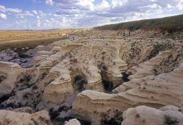
Badlands in the Niobrara Chalk of Gove County, one of many sites of extensive vertebrate fossil collecting in the 19th and 20th centuries.
The fossil huntersTwo of the earliest and best-known paleontologists to visit Kansas were Prof. Edward Drinker Cope (1840-1897) of Philadelphia and Prof. Othniel Marsh (1831-1899) of Yale University and the U.S. Geological Survey. Working at the cutting edge of paleontology, Marsh and Cope were friends at first, but were later caught up in the competition to name and identify fossils, each trying to earn priority for his work and lasting scientific fame (see Skelton, 1984). According to Schoewe (1965), Cope produced 36 papers on Kansas geology between 1866 and 1895, while Marsh produced nine, making Cope the most prolific publisher on Kansas geology during that period. Cope and Marsh began their competition about the same time that large vertebrate fossils were uncovered in western Kansas. Although both men visited the state--Cope in 1870 and Marsh in 1871--most of their collecting was done by surrogates who found the fossils, packed them, and shipped them east for identification and eventual placement in museums.Most Kansans who became involved with fossils did so through their work in the field. Perhaps the best example was Charles Sternberg, a native New Yorker who moved to Kansas and settled on his brother's ranch in Ellsworth County, where he found a large, fossilized, semi-tropical leaf in the Dakota Formation sandstone. The discovery so whetted his fossil-collecting appetite that he devoted the rest of his days to scouring the plains for the rocks and bones that represented life in the past. In his autobiography Sternberg wrote that "At the age of seventeen, I made up my mind what part I should play in life, and determined that whatever it might cost me in privation, danger, and solitude, I would make it my business to collect facts from the crusts of the earth" (Sternberg, 1909, p. 17). Sternberg sent his first collection of Dakota fossils to Spencer Baird at the Smithsonian Institution, and then began collecting with Leo Lesquereux (1806-1889), an expert on fossilized plants. In the mid-1870s, Sternberg went to Kansas State College in Manhattan to study with Benjamin Mudge, then a professor at Kansas State. When Mudge and Marsh, for whom Mudge was collecting at the time, denied Sternberg the chance to go into the field, Sternberg returned to free-lance collecting. Later he worked for Cope, whom he called "the greatest naturalist America has produced" (Sternberg, 1909, p. 33). Just as he said he would, Sternberg spent the rest of his life searching for fossils, usually collecting for Cope but occasionally selling on the open market. Sternberg's son George later joined him in the enterprise, and the pair became famous for their finds in the Cretaceous chalk. The Sternberg Memorial Museum at Fort Hays State University contains a number of the fossils recovered by the Sternbergs, including a famous fossilized fish of the genus Xiphactinus, with a smaller fish in its stomach.
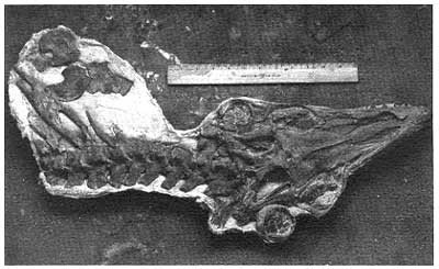
Skull and vertebrae from the mosasaur Platecarpus, collected in Logan County by Orville Bonner of the KU Museum of Natural History in the early 1970's.
Perhaps Mudge's most notable product was not a fossil but a student, Samuel Wendell Williston (1851-1918), a native of Massachusetts, who spent most of his childhood in Manhattan, Kansas, and then attended Kansas State. Williston collected fossils throughout Kansas, Colorado, and Wyoming, working mostly for Marsh until a disagreement caused Williston to move to the University of Kansas. In Lawrence, he not only taught geology but also became a renowned collector of insects, and worked for a time with the Kansas Geological Survey, a stint that included writing a series of some of the first Survey publications. Williston later left Kansas for the University of Chicago, but his work was probably as influential as any geologist in the late 1800s in Kansas. The sum of the labors of these men--Cope, Marsh, Williston, Mudge, Sternberg, and many others--was remarkable. Together they published widely and identified hundreds of fossils (according to Schoewe, 1965, 261 papers on Kansas geology were published from 1865 to 1895. Of those, 115 dealt with paleontology). In addition to Ichthyornis, they found previously unreported species of reptiles and fishes, fossilized dinosaur skin, several new species of pterosaurs, as well as hundreds of fossilized ammonites, clams, crinoids, and other ocean dwellers. Fossil hunting on the plainsThose discoveries not only led to scientifically important conclusions, but also produced legendary stories of brave and sometimes arcane behavior on the part of geologists. In the beginning, simply venturing onto the plains to collect fossils took a certain amount of courage. Hostile Indians still roamed western Kansas in the 1870s, although the final Indian attack in Kansas, at Oberlin in 1876, was really more of an accident of geography--a group of Northern Cheyennes from Indian Territory were attempting to move north and cut a swath through western Kansas on their way--than any real evidence of ongoing hostility. Troops from area forts occasionally escorted the collecting parties, but usually the geologists were on their own. "The few months of collecting done by Cope and Marsh was under ample protection of soldiers," Williston wrote later. "While yet the danger was fully as great or greater, the various other parties spent over thirty months in the same regions with no protection other than what their own rifles and revolvers afforded. Immigrants were massacred almost within rifle shot of the parties at different times, but fortunately no encounter was had by the explorers, though at times the danger was escaped almost marvelously" (Williston, 1898, p. 32).Charles Sternberg reported that on one of those encounters--the veracity of the report must be questioned--he stopped at Monument Rocks in Gove County, long known as a treasure trove for fossil collectors, when he saw a band of "Kiowas, Cheyennes, and Arapahoes, under the command of their famous chief, Crazy Horse, going north to join commands with Sitting Bull, in Montana" (Sternberg, 1909, p. 37). According to Sternberg, such encounters were not rare. "There was constant danger from Indians, and in order that we might escape as much as possible the eagle eye of some scout who might be passing through the country, our tent and wagon sheet were of brown duck" (Sternberg, 1909, p. 37). Despite the danger, Sternberg said that he "never carried my rifle with me" (Sternberg, 1909, p. 37). Most of the geologists' encounters on the plains were less serious. Othniel Marsh made his first trip to the state in the fall of 1871, and spent Thanksgiving in Wallace County, excavating near the site where the first mosasaur was uncovered in 1867. On the evening before Thanksgiving, the yelps of a coyote chased off most of the company's mules and horses, leaving the party stranded before a second escort from Fort Wallace came to the rescue (Marsh, 1972). Generally, though, Indians left the paleontologists alone, believing that they had to be crazy to spend time on the plains, looking at rocks (Merriam, 1984, p. 100). In fact, the collectors' worst enemies on the plains were probably not Indians or weather or animals, but each other. They went to great lengths to make certain that their work was not detected by other geologists. The Cope-Marsh dispute was especially bitter. By the time they moved on to Wyoming and Colorado, the two men used bribery and spying as standard tools to keep abreast of each other, and even took their argument to the popular press (Shor, 1974). In Kansas, they were just getting started. Cope and Marsh communicated with their collectors in the field in Kansas via coded telegrams so that their competitors could not discover where they were or what they had unearthed. When they made a discovery, they were sure to avoid giving it up to the competition. Once, when Sternberg learned of a new fossil in Scott County, he instructed the finder to cover the fossilized bones with a "small mountain over the top of it to hide it" until he could get there (Sternberg, 1909). At other times, fossil collecting inspired more mysterious behavior. Yale's Professor Marsh recounted the tale of returning to camp late one evening after a long day's work, when he noticed a fossilized bone protruding from a creek bank. He dug the bone out and in the darkness tried to mark the spot of his find. The next day Marsh left for Yale, where he later identified the fossil as a bone from the wing-tip of a pterodactyl, a particularly large species of the animal. Over a year later, Marsh came back to Kansas, rode straight to the same spot and found more bones from the same specimen (Marsh, 1972). Charles Sternberg produced an equally remarkable tale when he recalled dreaming one night of a fossil along a river bank. The next day he rode directly to the location and uncovered the fossil of his dreams, although he didn't find the method of discovery especially mysterious. "Probably my eyes saw the specimen while I was chasing an antelope or stray cow and too much occupied with the work in hand to take note of them consciously, until they were revealed to me by the dream, the only one in my experience that ever came true" (Sternberg, 1909, p. 36).
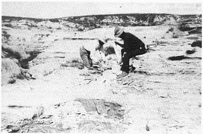
Plaster-jacking a fossil in the western Knasas chalk, 1903. Photo by S.W. Williston, courtesy of the University of Kansas archives, Spencer Research Library.
Throughout the 1870s, the primary figures in eastern Kansas geology were either from outside the state, or were working as surrogates. Charles Sternberg worked for Cope, Williston worked for Marsh, and Mudge, probably the most independent of the lot, still sent a number of specimens to Yale and other points east. In short, there was no geological institution within the state to direct the collection of Cretaceous fossils in western Kansas, and the state's colleges simply did not have the resources to take on the task. A geologic map of KansasThe only state agency that continued geologic research outside of an academic setting was the Kansas State Board of Agriculture, formed in 1872 to encourage immigration to Kansas and to educate farmers about new agricultural techniques. A year after the Board's formation, it created the position of staff geologist and hired Mudge for the job. In the 1874 edition of the Board's report to the Kansas legislature, Mudge wrote a general report on Kansas geology--a sort of state-of-the-art review of what was known about the state, patterned along the lines of his 1864 report as state geologist--and included what was probably the first published geologic map showing only the state of Kansas.On that page-sized map Mudge showed four major geologic divisions in Kansas: the Coal Measures of southeastern Kansas (where most rocks at the surface are today labeled Pennsylvanian); the Upper Carboniferous, covering most of the Flint Hills and northeastern Kansas (mostly Permian rocks, but also including some glacial deposits); the Cretaceous, which included almost all of the western two-thirds of the state; and a small patch in the northwest corner labeled Pliocene (usually referred to today as Tertiary in age). Although Mudge did not differentiate Permian strata on the map, he knew that the Permian existed in Kansas. "The line of demarcation between the Cretaceous and Pliocene is well-defined and sharp; but adjoining the Permian it is not so clear, as at many points the fossils are not to be seen, and the shales of both periods have a common appearance" (Mudge, 1875). Finally, in the text accompanying the map, Mudge discussed the Lower Carboniferous (or Mississippian) in extreme southeastern Kansas, although it was not shown on the map itself. In all, Mudge's map by itself probably represented no great leap forward in geologic knowledge, although it did finally give the state's residents and the country's geologists a workable map to use in studying the state. Finally there was a published map of the state's geology, synthesizing most of what was known about Kansas geology. Geologic maps that included Kansas, or parts of the state, had been drawn and published before. But the publication of Mudge's map in 1874 finally made it accessible to everyone who could obtain a copy of the Board's report. For geologists, a geologic map represents a beginning point. Much the way a road map provides a guide for a traveler who is unfamiliar with the territory, a geologic map provides geologists with a notion of what to expect in a region's geology. Part of the information that went into Mudge's geologic map of Kansas came, again, from the fossils in western Kansas. Twice during the 1870s, Mudge spent six months in the field collecting fossils for Yale College, and the knowledge he gained during those expeditions was probably responsible, at least in part, for firming up his notions of the Cretaceous and the Tertiary in northwestern Kansas, and led to the eventual production of the geologic map. Until his death in 1879, Mudge continued to refine that map and to explore the state, and when the Board of Agriculture published a biennial report in 1877, Mudge included a revised geologic map of the state (Mudge, 1877). This map was also page-sized and once again subdivided Kansas into four geologic provinces, but this time he made subtle, yet important, improvements. While the new map left the Coal Measures in southeastern Kansas almost completely unchanged--which is hardly surprising since that area of the state was probably the best known before publication of the first map in 1875--and the border between the Upper Carboniferous and the Cretaceous was left largely the same, there were dramatic differences in the extent of the Pliocene and the Cretaceous. For the first time, Mudge showed a large stretch of Pliocene in Greeley, Wichita, and Scott counties in west-central Kansas, an area that he had previously labeled entirely Cretaceous. The border between the Cretaceous and the Pliocene in northwestern Kansas was also less linear, as Mudge began to recognize the fingerlike projections of the Tertiary formations in, for example, Rooks and Graham counties. Yet he retained the Cretaceous in Wallace County, where a number of the first Cretaceous vertebrate fossils were discovered. Mudge extended the Cretaceous formations into southwestern Kansas (where they are actually far more rare and scattered than in northwest or west-central Kansas), suggesting that he had yet to make extended visits to that corner of the state, which lacked the lure of vast fossil deposits, at least as far as anyone knew at the time. In short, the 1870s were to western Kansas what the 1850s and 1860s were to eastern Kansas: a time of reconnaissance, a time when initial ideas about stratigraphy and resources were established. Mudge was succeeded by Orestes St. John as the Board's geologist. Like Mudge, St. John continued to refine the geologic map of Kansas in the Board's 1881-82 report (St. John, 1883). The differences between Mudge's 1875 map and St. John's 1881 map were hardly noticeable, with one exception: St. John finally showed the extent of the Lower Carboniferous in southeastern Kansas. The addition was not particularly significant and was probably occasioned by lead and zinc mining in the Mississippian strata. Mudge had known of the formation and simply not added it, perhaps because it was so small. St. John added the Lower Carboniferous, along with a nicely drawn cross section (something that Mudge had not included). In essence, during the 1870s the State Board of Agriculture assumed many of the duties of the state geological survey. Mudge, St. John, Robert Hay, and other staff members at the State Board of Agriculture continued to carry on the role of the state survey, even though it was not provided for specifically by the state legislature. State government seemed to recognize the need for geologic expertise and was willing to support it. Mineral productionAt the same time that Mudge and St. John were handling geologic matters for the State Board of Agriculture, geology was taking on a larger role in the Kansas economy, and not just in relation to farming. Production of oil, coal, salt, natural gas, lead and zinc, gypsum, and even ground water increased in the 1870s and 1880s, bringing mineral production to the forefront of the state's economy.One of the first minerals discovered, and ultimately the most important, was oil. Kansans were aware of oil seeps in the state long before the first well was drilled in the 1860s. A Dr. G.W. Brown, after observing an oil seep on Wea Creek in Miami County, drilled three wells near Paola, and produced a combination of oil and saltwater from the third well (Schraben, 1972; Miner, 1987; Haworth, 1908). But the Civil War and Quantrill's raiders combined to take away capital for additional drilling. At the time, oil was used primarily as a lubricant and sold for only $3 to $5 per barrel, so no great drilling boom developed in Kansas even after the Civil War. After Brown's venture, wells were drilled from time to time in eastern Kansas during the 1860s and 1870s, but they represented no real flurry of activity. In the 1870s, much of the drilling activity centered instead around natural gas. By the time Mudge had completed his 1875 report on the state's geology, gas wells were relatively common in eastern Kansas, and gas was supplying heat and light to many of the homes in area cities, including Iola, Wyandotte, and Fort Scott (Haworth, 1908, p. 27-29). In fact, one of the earliest wells--drilled in 1873 near Iola--was originally bored in search of coal, but at about 600 feet hit a mixture of gas and mineral water, providing water for bathing and natural gas for a sanatorium that was soon built at the site (Patrick, 1877). In the 1880s and 1890s, the abundance of natural gas created an economic boomlet in southeastern Kansas, where residents discovered several minerals that required heat for manufacture or smelting. Thus, the fortuitous combination of natural gas with clay and lead and zinc deposits led to the location of a number of brick plants and smelting operations in southeastern Kansas, nearly all dependent on the supply of cheap, plentiful natural gas. When that supply began to play out, however, factories and plants began to close, causing regional economic problems that lasted well into the 20th century (Clark, 1970). Natural gas was not the only mineral that led to flush times. In 1870, in extreme southeastern Kansas, came the first reports of zinc ore. Those reports centered on the area covered by the Lower Carboniferous on the contemporary geologic map, and they were probably not too surprising considering that lead and zinc had been mined in Missouri for some time. Serious mining got underway in Kansas in 1876, with the discovery of lead ore near a town called Bonanza, and in March 1877, another body of lead ore was discovered near the town of Galena (Haworth and others, 1904). The resulting boom was probably the most dramatic in Kansas history. Within the next 30 days, witnesses estimated that some 10,000 people poured into the area. "It seemed to be a time when there was no other attraction of the kind, and those who had been through the California and other discoveries of valuable ores claimed never to have seen so large a collection of the tough element as was gathered in this territory at that time," wrote an area resident. "The gambler, the fakir, the confidence man, the saloon-keeper and the frail woman were masters of the situation, the 'bon ton' as it were, and nothing but the fear of each other prevented absolute lawlessness and the shedding of blood" (Stone, 1902, p. 250). Overnight the town of Empire City was formed to the north of Galena, boasting a population of over 2,000 in less than two weeks after the city was founded. On July 4, 1877, Empire City threw a barbecue that attracted, according to one estimate, 25,000 people (Stone, 1902, p. 252). By the end of the 19th century, the Tri-state mining district, as it came to be called, was among the world's leaders in the production of zinc ore. But like the natural gas strikes in southeastern Kansas, lead and zinc mining began to play out later in the 1900s. In part the decline was due to the depletion of rich ores, and in part it was caused by the disappearance of cheap supplies of natural gas, which had made smelting an economic enterprise in southeastern Kansas. The economic attraction of the minerals had greatly declined by the Great Crash of 1929 (Clark, 1970), and by 1970, the days of lead and zinc mining and smelting in Kansas were over. Some of the state's other minerals did not disappear so quickly. The state's earliest residents found salt marshes scattered throughout central Kansas, and they soon used the brine to salt hides and meat. By the 1880s, as Kansans began to drill wells in search of coal or oil or other minerals, the settlers in central Kansas often had to bore their way through several hundred feet of salt. As a result, the first major salt-producing plant in the state was erected in Hutchinson in 1888, and by the end of the year, 12 other factories were located around the state (Haworth, 1898b). All those mines produced salt from the Permian Hutchinson Salt Member of the Wellington Formation; that salt bed underlies much of central Kansas, and several salt mines remain active there today.
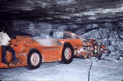
Drill in salt mine, Reno County in central Kansas.
Also during the late 1800s, other geologic resources came into prominence. Gypsum was produced for years at several locations around the state, from Marshall County in the north to Medicine Lodge in the south. By the mid-1880s, in fact, Kansas was the leading gypsum-producing state in the union, a status that did not last long (Grimsley and Bailey, 1899). One other mineral was also exploited during the later 1800s: ground water. Surface water had been exploited for some time, beginning with the Indians who dug irrigation ditches near Lake Scott in Scott County. Settlers later dug extensive irrigation ditches along the Arkansas River in southwestern Kansas. But in the 1890s, ground water was used for irrigation in large amounts, and by the end of the century, geologists at the State Board of Agriculture began to chronicle its use and were studying flowing wells in various parts of the state (St. John, 1885; Hay, 1891). The economic impact of this activity--production of oil, gas, salt, gypsum, coal, ground water, lead, zinc--must have been impressive. At the end of the Civil War, there was no commercial mining in Kansas on a continuing basis, save for the production of coal, which was only used locally because of transportation costs. But by 1889, the state had witnessed an increase in mineral production that went far beyond simply providing residents with the requisite shelter and fuel. Now minerals were providing an economic livelihood throughout the state--through natural gas, the base for industries in southeastern Kansas; through lead and zinc, which led to a mining boom in southeastern Kansas; through salt, which was mined extensively in central Kansas; through coal, which was being mined in amounts large enough to allow its export outside the state; through oil, which was coming into its own as a source of energy as the 19th century came to a close; through ground water, which was enhancing Kansas status as an agricultural state; and even through gypsum. It amounted to a mining boom in Kansas. At about the same time, Cretaceous fossils were being discovered and identified throughout much of northwestern Kansas. The fossils, it seems, fascinated the public the way that ancient bones always have. And the minerals captured their economic attention. The minerals and the bones combined to focus attention on Kansas's geologic wealth in a way that had never occurred in the state's history. The result was not only a revival in interest in geology, but the re-appearance of a geological survey. |
|
Kansas Geological Survey, KGS History Comments to webadmin@kgs.ku.edu Web version February 2003. Original publication date 1989. URL=http://www.kgs.ku.edu/Publications/Bulletins/227/06_hiatus.html | ||