Kansas Geological Survey, Bulletin 204, part 2, originally published in 1972
Originally published in 1972 as Kansas Geological Survey Bulletin 204, part 2. This is, in general, the original text as published. The information has not been updated.
Gravity measurements support the hypothesis that an abandoned lead and zinc mine near Pleasanton, Kansas, is associated with a slump pipe. A negative gravity anomaly closure of ≈ 0.4 mgal is consistent with a brecciated zone extending at least 600 feet through basal Pennsylvanian strata and into those of the Mississippian. A second negative gravity anomaly of the same magnitude occurs several hundred feet north of the first and may correspond to a similar slump structure. This second anomaly remains unexplored to date. Magnetic field measurements show no apparent correlation with slumps in this area.
Lead and zinc were first mined in Kansas in Linn County about 1840. This preceded by 35 years the development of commercial mining in Cherokee County, a part of the Tri-State lead and zinc district. Small-scale mining continued in Linn County on an intermittent basis until 1940 (Schoewe, 1959). The most prominent evidence of this mining activity is the old Jumbo mine which is located in the SE sec. 5, T. 22 S., R. 25 E., about 1 mile east and 1 mile south of the southeast corner of the city of Pleasanton (Fig. 1).
Figure 1--Location and topography of Jumbo lead mine (after U.S.G.S. 7.5 Minute Series, Pleasanton Quadrangle, 1958).
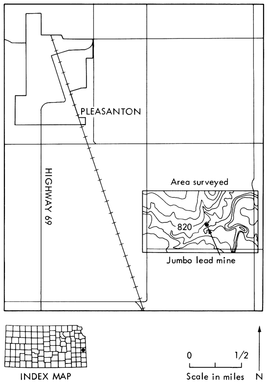
Figure 2--Topography of Jumbo mine spoil mounds.
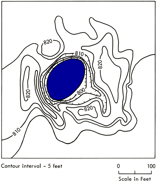
The mine, located in a mature wooded area, is an open circular pit approximately 125 feet in diameter. It ranges from 30 to 50 feet in depth and usually is filled with water to within 10 feet of the ground surface. The mine is surrounded by spoil mounds composed of limestone, shale, sandstone, coal, and numerous particles of galena and sphalerite. The maximum height of the mounds is about 20 feet above the original ground surface (Fig. 2).
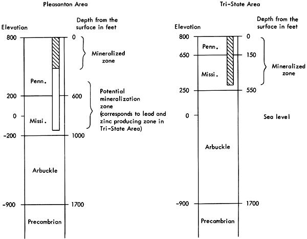
Outcropping rocks in the mine area belong to the Nowata Shale which is part of the Marmaton Group of Pennsylvanian age. The Pennsylvanian rocks extend to a depth of 600 feet and consist predominantly of shale, with lesser amounts of limestone, sandstone, and coal. Mississippian rocks underlie Pennsylvanian sediments to a depth of 1000 feet, below which rocks of the Arbuckle Group extend to the Precambrian surface at a depth of 1700 feet (Fig. 3).
Figure 3--Generalized stratigraphic columns of Pleasanton and Tri-State areas.
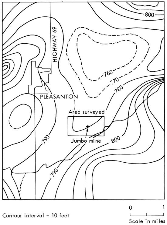
The Pleasanton area is located on the westerly dipping (≈20 feet/mile) Prairie Plains monocline which is the western flank of the Ozark uplift. Local folds in the area range from 10 to 50 feet in structural relief. A structural map of the base of the Worland Limestone Member (Fig. 4) shows that the Jumbo mine is located on the eastern flank of a gentle syncline which is aligned in a northeast-southwest direction. This structure is not well expressed in the present surface topography (see Fig. 1). More complete discussions of the surface and subsurface geology of this area are given elsewhere (Padgham, 1957; Schoewe, 1959; Hatcher, 1961; Seever, 1969).
Figure 4--Structure contours on top of the Worland Limestone in Pleasanton area (after Padgham, 1957, Plate 1).
The Jumbo mine reportedly was sunk to a total depth of 300 feet (Fig. 3) and, according to previous owners, at least some galena and sphalerite were encountered at most levels in the rock column. Schoewe (1959) believed that the Jumbo ore deposits were related to a circular collapse structure or slump pipe. There is presently no obvious surface expression of a slump at the mine site. Lead and zinc ore is produced from slump structures in the Tri-State district (Brockie, et al., 1968; McKnight and Fischer, 1970). Most of these slumps extend a considerable distance through the Mississippian rocks and may be due to solution of the St. Joe Limestone, the oldest Mississippian limestone member in the area (McKnight and Fischer, 1970).
Slumping at the Jumbo mine may extend downward to the Mississippian formations which are the host rocks for mineralization mined from the Tri-State district. These formations occur at a depth of about 900 feet in the Pleasanton area (see Fig. 3). Although most of the Tri-State lead and zinc ore is found in Mississippian rocks, the age of mineralization is probably post-Pennsylvanian (McKnight and Fischer, 1970). Thus the Pleasanton and Tri-State ores may have a common origin. Lead from both areas contains anomalously high percentages of the three radiogenic isotopes Pb206, Pb207, and Pb208 (called J- type or Mississippi Valley-type lead) which lends support to a hypothesis of common origin. In addition, lead from the Jumbo mine yielded a Pb206 /Pb207 ratio of 1.4 (Angino, et al., 1971) which is similar to that found in the lead districts in southeastern Missouri, the Tri-State area, and the Upper Mississippi Valley. McKnight and Fischer (1970) suggest that lead and zinc ore in all of these districts may be related to a broad region of low-level igneous activity.
This study of the Jumbo mine was undertaken to test the applicability of gravity and magnetic measurements to the search for lead and zinc ore. Under favorable conditions knowledge of the gravity and magnetic fields might provide information about subsurface structure, including the existence and extent of slump pipes or other brecciated zones.
Jakosky, et al. (1942) tried to correlate gravity and magnetic measurements with location of ore deposits in Mississippian rocks in the Tri-State district. They found several small gravity lows (<0.2 mgal) which did coincide with location of ore, but there were an equal number of non-correlations. Jakosky, et al. does not indicate if the gravity and magnetic fields correlate with slump structures in the area which are presumably associated with the ore deposits. In any case, slumping in Pennsylvanian strata and Mississippian strata may produce different gravity anomalies due to different density contrasts between disturbed and undisturbed rock.
We are grateful to numerous colleagues in the Kansas Geological Survey for their suggestions, advice, and discussions concerning geology and geophysics of the Pleasanton area. Very useful contributions from J. A. Peoples and E. J. Zeller, Department of Geology, The University of Kansas, were much appreciated. We are particularly grateful to students J. L. Wall and J. J. Simms for their enthusiastic help in the earlier stages of field work and data analysis. We thank J. R. Chelikowsky, Department of Geology, Kansas State University, for the loan of his proton magnetometer. Finally, many thanks to D. C. Brockie of Eagle-Picher Industries, Inc. for providing drill logs, location maps, and graphic logs for the Jumbo mine area.
Gravity and magnetic measurements were taken at 162 stations. Station density (see Fig. 6) was dictated by the desire for a general picture away from the mine and careful control near the mine. Station elevations were determined by direct leveling using a theodolite for about two-thirds of the elevations and a plane table and alidade for the remainder. The maximum sight distance (or station spacing) permitted by the densely wooded area around the mine was about 100 feet. Indirect leveling was used to determine the relief of spoil mounds immediately around the mine (Fig. 2).
The relative changes in gravitational attraction at the station locations were measured using a Worden Gravimeter with 0.01 mgal/division precision. Five base stations were established throughout the area for determining instrument drift curves, and were later tied to a single base. A base station reading was taken on the average of every 1 1/2 hours during the course of a day.
Total magnetic field intensity was measured using a portable proton magnetometer (Varian Model M49A) with 10 gamma/division precision. Corrections for diurnal variation were determined by approximately the same procedure used for the gravity drift curves. Care was taken to avoid magnetic field distortions from power lines, fences, culverts, etc. Because of the larger amount of metal debris near the mine, it was impossible to obtain reliable magnetic field measurements in this area. All such stations were deleted from the data before contour maps were prepared.
Gravity readings were corrected for instrument drift, then adjusted to one convenient datum level using base stations measured in common during the various daily traverses. This resulted in a measured gravity value gi, in milligals, for each station i. The final Bouguer gravity value Δgi, in milligals, was determined by
Δgi = gi - g*i
where
g*i = 978.0490 (1000.0 + 5.2884 sin2φi 0.0059 sin22φi)
- hi (0.09416 + 0.0009 cos2φi - 0.01276ρi)
and is the theoretical absolute gravity value, in milligals, at station i due to a transversely isotropic spheroidal earth (for further discussion see Grant and West, 1965, p. 236-239). g*i accounts for relative station differences in elevation above sea level (hi in feet), latitude (φi in radians), and subsurface density above sea level (ρi in gm/cm3).
Since gi is not an absolute measurement, but has an arbitrary base level chosen for convenience, hi is effectively the height above the lowest station elevation (797 feet) and ρi is the density of material above the 797-foot level. Thus ρi represents the density of the subsurface column under station i that extends to a depth ranging from 0 to 50 feet, depending on the station elevation. From general knowledge of the near-surface soil and rock column, it was assumed that ρi does not vary significantly and its value was set at 2.1 for all stations. For an alternate determination of density, the technique of density profiling using both the graphical method (Nettleton, 1940, p. 57) and the numerical method (Grant and West, 1965, p. 242) was employed. However, due to the relatively small amount of relief in the area, the results were less conclusive than from general knowledge of subsurface rock types.
The topography of the area is smooth enough to neglect terrain corrections except for stations near the mine. To account for reduced vertical gravitational attraction due to the open pit and the spoil mounds, terrain corrections (which were added to the Bouguer gravity values) were made using Figure 2 together with terrain correction tables (Nettleton, 1940, p. 145). The magnitude of these corrections ranged from 0 to 0.15 mgal.
The Bouguer gravity is essentially a sum of independent measurements which are presumed to have normally distributed errors. [Note: This is not completely true because one term involves the product ρi x hi, however, the effect of this approximation on the error analysis is negligible since σ3 and σ4 are relatively small.] The individual sources of error and their estimated standard deviations are instrument drift (σ1 = 0.07 mgal), instrument reading (σ2 = 0.04 mgal), density determination (σ3 = 0.02 mgal), elevation determination (σ4 = 0.01 mgal), and terrain correction (σ5 = 0.02 mgal). The total error in the Bouguer gravity will also be normally distributed with standard deviation 0.09 mgal which was determined by
![total error = square root of the [sum from 1 to 5 of the square of the individual errors].](gifs/equ1.gif)
(for further discussion on the addition of normal distributions see Cramer, 1970). The relatively high error due to instrument drift resulted from a somewhat nonlinear drift caused by poor temperature compensation.
The magnetic readings were corrected for diurnal variation, then tied to a common base. Annual, secular, and topographic effects were negligible. The latitude and longitude effects for the area, which are ≈12 and ≈2 gammas/mile respectively (Jakosky, 1950), are too small for meaningful corrections to the data. The total uncertainty for the measured total magnetic field is estimated to be ±11 gammas and is based on instrument reading error and uncertainty in the diurnal correction.
For aid in interpretation, a series of residual gravity contour maps, up to eighth order, was made using the residual quantities Δgikmax determined by
where the last term on the right represents a polynomial surface fit, of order kmax, to the Bouguer gravity values Δgi with station coordinates (xi, yi). The parameters Ak1 were determined by a least squares minimizing procedure (for further discussion and previous applications to gravity data see Coons, et al., 1967). Residual magnetic maps were prepared using the same procedure.
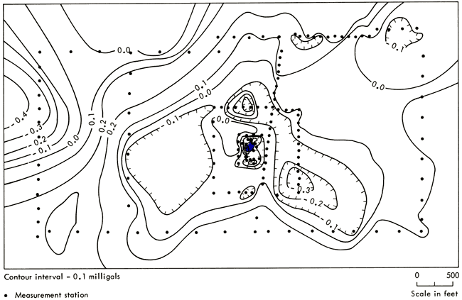
The Bouguer gravitational field for the study area is shown in Figure 6. The first order fit to this map, which should represent the local deep-seated gravity, indicates a 1.5 mgal/mile decrease from east to west. This is 4 to 7 times higher than the regional east to west decrease in this area (Fig. 5) which implies considerable local relief on the Precambrian surface or a lateral density change within the basement rocks. A map of the Precambrian surface configuration (Cole, 1962) shows little relief in the Pleasanton area, however the scale and control does not permit accurate determination of local relief in the small area under study. The regional Bouguer gravity map (Fig. 5) shows a 5-mgal negative anomaly closure about 5 miles west of Pleasanton. Woollard (1959) attributes this to an intrabasement body composed of a less dense acidic rock. The rather steep gravity gradient in the Jumbo mine area may be associated with a basement lithology transition zone at the edge of this suggested intrabasement body.
Figure 5--Regional Bouguer gravity for eastern Kansas (after Woollard, 1959, Plate 1).
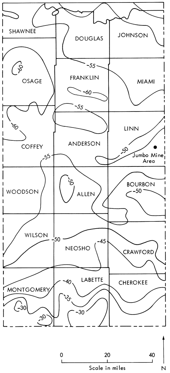
Figure 6--Bouguer gravity of Jumbo mine area.
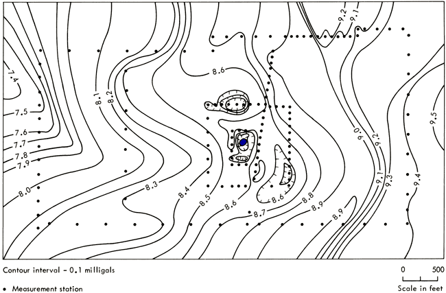
Other significant features of the Bouguer gravity map (Fig. 6) are the linear east-west trend across the southern half of the area and small anomalies at the mine and approximately 600 feet north of the mine. The mine area is shown in more detail in Figure 7. The negative anomaly (≈0.4 mgal) at the mine is slightly elongate north-south with the minimum value occurring at the western edge of the present mine opening. The negative anomaly to the north (also 0.4 mgal) appears circular, however, the north-south contour control is poor. A smaller negative anomaly (≈0.2 mgal) is evident approximately 800 feet southeast of the mine.
Figure 7--Bouguer gravity of Jumbo mine.
A map of the total magnetic field for the area is presented as Figure 8. The absolute magnitude of 56,000 gammas is consistent with the value expected for this central region of the United States (Strahler, 1963, p. 145). The field increases towards the north-northeast at 200 gammas/mile. There are no regional total magnetic field data available for this area, but this gradient agrees fairly well in direction and magnitude with the regional aeromagnetic gradient 5 miles to the east on the Kansas-Missouri border (see Zeitz and Kirby, 1968). The consensus from previous magnetic data (Merriam and Hambleton, 1959) is that gross features in Kansas are largely controlled by Precambrian intrabasement rock type. This is probably true in the Pleasanton area, particularly since the local gradient appears consistent with the 10-mile north-south regional gradient.
Figure 8--Total magnetic field for Jumbo mine area.
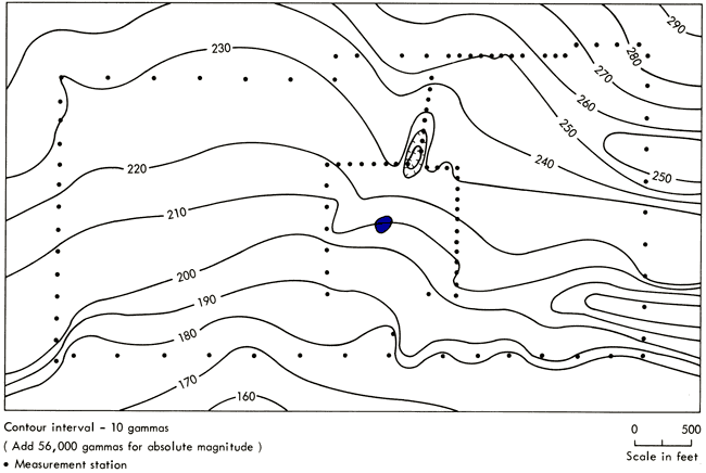
The large quantity of surface and buried scrap metal (debris from the old mining operation) prohibited measurement closer than 500 feet to the mine. Except for a small 20-gamma anomaly low about 700 feet north of the mine, the magnetic field through the mine area appears to conform with the regional picture.
A first order residual gravity map of the area is presented as Figure 9. The residual gravity surface is determined by subtracting the first order fit to the Bouguer gravity surface from the original Bouguer gravity surface (Fig. 6) and should be a better approximation to the gravitational field produced by near-surface sources. Since the first order fit represents the linear gravitational field produced by deep-seated sources, the gravity data on the mine area and the anomaly to the north were not included in the fit. This exclusion is justified, and in fact required, because anomalies of such a small lateral extent cannot originate at great depth.
Figure 9--First order residual Bouguer gravity of Jumbo mine area.
A new feature revealed by the residual map (Fig. 9) is a positive gravity ridge which extends north-northeast from the southwest corner of the study area. This ridge coincides with a gentle synclinal structure which appears on the structure contour map of the base of the Worland Limestone about 50 feet below the surface in the area of the Jumbo mine (Fig. 4).
A cross section of the area several miles west of the Jumbo mine (Padgham, 1957) shows that structure is amplified in the lower horizons such as the Pawnee Limestone (100 feet below surface) and the Fort Scott Limestone (180 feet below surface). These formations are shown to be considerably thicker in the structural lows, and the gravity ridge shown in Figure 9 may be due to the relatively thick limestone beds in the coincident synclinal structure. The structure map of the Worland Limestone (Fig. 4) also exhibits a subtle east-southeast-west-northwest trend through the area which appears to correlate somewhat with the gravity maps in Figures 6 and 9.
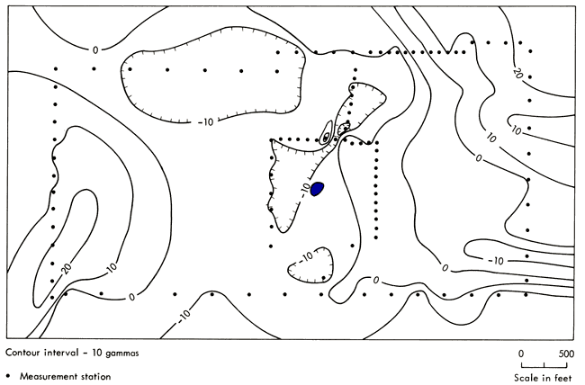
The first order residual magnetic map (Fig. 10) also reveals a high (≈20 gammas) centered in the southwest corner, although there is no clear northeast extension of this corresponding to the gravity ridge (Fig. 9). The sources of this magnetic high may also be related to thicker strata along the synclinal structure. The iron oxide content of sandstone and limestone in this area may influence the magnetic field to some extent; no specific magnetic susceptibility measurements are available. The area near the mine and to the northeast is located in a magnetic low; however, the magnitude (≈10 gammas) is too small to consider this a significant correlation. Because of absence of measurement stations immediately around the mine, this is a poor correlation test. There is also no striking magnetic correlation with the gravity anomaly to the north, although there is a small positive anomaly closure (≈20 gammas) on the eastern edge. The interpretation of this is uncertain, particularly since the possibility of buried scrap metal cannot be ruled out.
Figure 10--First order residual total magnetic field of Jumbo mine area.
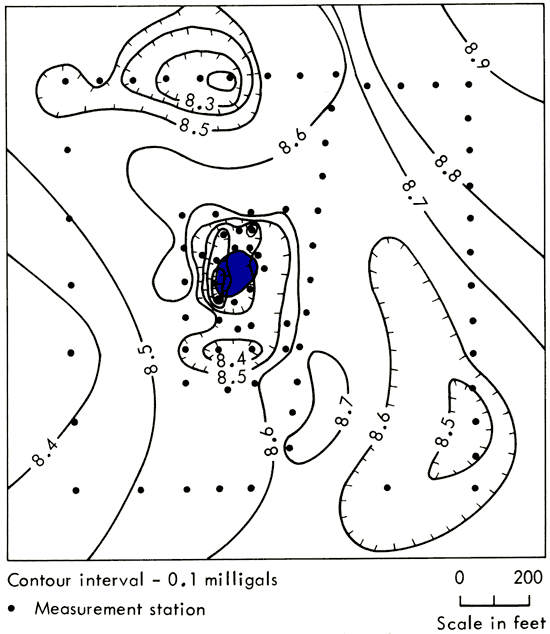
The gravity residual map (Fig. 11) does not significantly change the size or magnitude of the negative anomalies present on the original gravity map (Fig. 7). These gravity results indicate that the mine is approximately centered in a region of relatively low density material which would be expected in a collapse structure or slump pipe. The slumping would create broken rock with increased void space. Maximum density contrast or maximum brecciation appears to have occurred to the west and northeast of the mine. These two areas of maximum brecciation could well be part of a single area that extends across the open pit, but was undetected due to lack of gravity measurements in the pit.
Figure 11--First order residual Bouguer gravity of Jumbo mine.
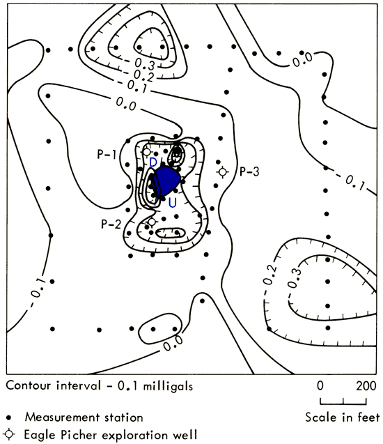
A north-south fault through the mine opening (Fig. 11) is easily visible when one stands on the east side of the pit and looks west. Sandstone beds (probably Walter Johnson Member of Nowata Shale) are west of the fault line in the exposed vertical wall of the pit between the water level and land surface. East of the fault line the beds are not visible, indicating a fault as shown on Figure 11. The exposed sandstone beds on the north and south walls (west of fault line) have apparent dips of 10° to the southwest and 5° to the northwest respectively, indicating that the sandstone was dragged upward along the fault. This observation established the relative vertical displacement shown in Figure 11. Since the sandstone is not visible east of the fault, there is at least 5 feet of vertical displacement.
In 1965 Eagle-Picher Industries, Inc. drilled three exploratory wells, P-1, P-2, and P-3, to depths of 986, 980, and 239 feet respectively. The drill records are part of Eagle-Picher's confidential files, however, the Kansas Geological Survey was given permission to use them for determination of depths to various marker beds. As shown on Figure 11, P-1 and P-2 are inside the western edge of the gravity low or slumped area, while P-3 is outside of the anomaly closure, 100 feet to the east. The easily identifiable markers that can be compared in the three wells are the tops of the Altamont Limestone (50 feet depth), Pawnee Limestone (110 feet depth), and Fort Scott Limestone (185 feet depth). The markers in P-2 are lower in elevation than those in P-1, by 4, 6, and 7 feet respectively, while the markers in P-3 are higher than those in P-1 by 11, 14, and 10 feet respectively. Although these elevation differences relative to distance between borings are not unusual for this area, they are quite consistent with the slumped area outlined by the gravity low. P-2 is located inside the gravity low and should penetrate beds that have slumped relative to beds at P-1 and P-2. Similarly, beds at P-3 should be relatively undisturbed and higher than those at P-1 and P-2. The structure map (Fig. 3) shows the mine located on northwesterly dipping beds, but the local dip accounts for only a 2-foot difference in elevation between P-1 and P-3.
Elevations of the marker beds also are consistent with the observed vertical displacement along the fault. The lateral extent of the fault is not evident. Although the fault is visible in the walls of the pit, there is no surface expression to the north or south of the pit. It could be a relatively short fault associated with differential settling in the slump or it could be an independent feature which extends for a considerable distance to the north and/or south.
The negative anomaly closure about 600 feet north of the mine is very similar to the mine anomaly (Fig. 11). The more symmetrical shape of this anomaly probably results from fewer measurement stations in the area. As is the case around the mine, no surface expression of slumping is evident, but an anomaly of this size indicates an extensive zone of low density material which is consistent with slumping and its associated brecciation. No faulting is visible, but it is interesting to note that a northern extension of the fault exposed at the mine would pass through the eastern edge of this anomaly.
Several higher order (greater than first) residual gravity maps were examined. No new structural features were revealed that would add to the interpretation. Also, due to lack of information about intrabasement lithology and the small size of the study area, there is no justification for assigning a higher order to the deep-seated gravitational field.
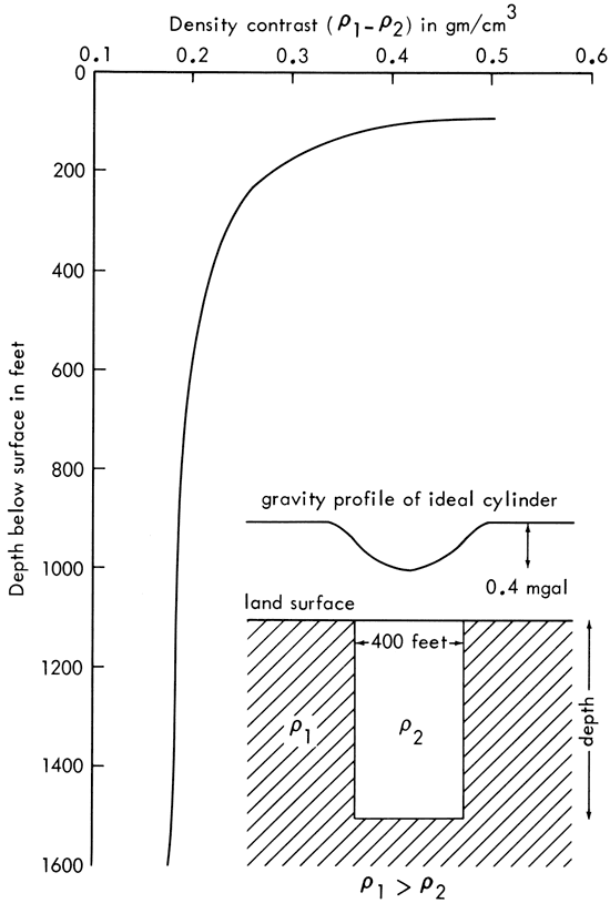
An attempt was made to determine the vertical extent of the slumps. Examination of profiles through the anomalies to determine the full width at half-maximum amplitude indicates that a diameter of ≈400 feet is representative in both cases. A fairly good approximation to the brecciated zone would be a vertical cylindrical volume of low density relative to the surrounding rock. For a cylinder of known diameter (400 feet) producing a known negative anomaly (0.4 mgal), the possible values of cylinder depth versus density contrast are readily calculable (see e.g., Ramsey, 1961, p. 40). The resulting curve (Fig. 12) indicates that density contrast decreases rapidly for cylinder depths down to ≈700 feet. Below 700 feet the density contrast decreases slowly and is almost independent of depth. It is clear from this approximate analysis that a 400-foot diameter cylinder, which produces a 0.4 mgal anomaly, extending from the surface to a depth between the top of the Mississippian (600 feet) and the top of the Precambrian (1800 feet) requires a density contrast of ≈0.2 gm/cm3. This implies that the material in the slump has ≈7 percent more void space than the surrounding rocks, which is within reason. If the slump is much shallower than 600 feet, the required density contrast is probably unrealistic. These conclusions hold for cylinder diameters between 350 and 450 feet.
Figure 12--Density contrast versus depth for "ideal" cylindrical slump.
In early fall 1971, infrared and color photographs of the area were taken at altitudes of 1000, 5000, and 10,000 feet. The details of this study are available in an unpublished report by Pincomb (1971).
The aerial photographs were examined, but no striking correlations with the mine, gravity anomalies, or fault were noted. However, it is possible that a correlation exists between early assumption of fall coloration by trees and negative gravity anomalies. A more thorough study of tree types and distribution is required to confirm this possibility.
Results of the gravity study support the hypothesis that the Jumbo mine is associated with a collapse structure or slump pipe. The negative gravity anomaly closure indicates a less dense subsurface material around the mine that is consistent with a brecciated zone. The size of the anomaly corresponds roughly to a slump pipe with a diameter of 400 feet. Although not conclusive, the magnitude of the anomaly (≈0.4 mgal) slightly favors a pipe that extends from the surface to a depth of at least 600 feet. The most intense brecciation appears to be associated with a fault that runs through the mine opening. However, the relation of the fault to the slump is not clear.
Another negative gravity anomaly (also ≈0.4 mgal) occurs ≈600 feet north of the mine and probably corresponds to a similar slump structure. There is no correlation between the magnetic field and this gravity anomaly, which suggests that slumps in this area do not produce magnetic anomalies. Metal debris prevented magnetic field measurements around the mine.
If the suggested size of these apparent slumps warrants further prospecting, then the best drilling sites would probably be immediately west and northeast of the present mine opening and in the center of the anomaly which occurs 600 feet north of the mine.
Linear residual gravity and magnetic highs west of the mine area appear to correlate with relatively thick sandstone and limestone beds along the axis of a subsurface synclinal structure.
Finally, an attempt was made to correlate tree density and leaf color with the gravity anomalies in the wooded area around the mine using color and infrared aerial photos (Pincomb, 1971). No striking correlations were found, but suggestions of some subtle correlation indicate that a more thorough photobotanical study may be warranted.
Angino, E. E., Goebel, E. D., and Waugh, T. C., 1971, Lead isotopes and metallic sulphide as exploration guides in Mid-Continent Paleozoic rocks: CIM Special Volume No. 11, Geochemical Exploration, 1971, p. 1-4.
Brockie, D. C., Hare, E. H., Jr., and Dingess, P. R., 1968, The geology and ore deposits of the Tri-State district of Missouri, Kansas, and Oklahoma; in Ridge, J. D., ed., Ore Deposits of the United States, 1933-1967, Vol. 1: Am. Inst. Mining Met. Eng., New York, p. 400-430.
Cole, V. B., 1962, Configuration of top of Precambrian basement rocks in Kansas: Kansas Geol. Survey, Oil and Gas Invest. no. 26, map. [available online]
Coons, R. L., Woollard, G. P., and Hershey, Garland, 1967, Structural significance and analysis of Mid-Continent gravity high: Am. Assoc. Petroleum Geologists, Bull., v. 51, no. 12, p. 2381-2399.
Cramer, Harald, 1970, Random Variables and Probability Distributions: Cambridge University Press, Cambridge, p. 51.
Grant, F. S., and West, G. F., 1965, Interpretation Theory in Applied Geophysics: McGraw-Hill Book Co., New York, p. 236-239.
Hatcher, D. A., 1961, Stratigraphy of the Pleasanton Group in Miami, Linn, and Bourbon counties, Kansas: Unpub. M.S. thesis, Dept. Geology, Kansas University, 65 p.
Jakosky, J. J., 1950, Exploration Geophysics: Trija Publishing Co., Los Angeles, p. 141-142.
Jakosky, J. J., Dreyer, R. M., and Wilson, C. H., 1942, Geophysical investigations in the Tri-State Zinc and Lead Mining District: Kansas Geol. Survey, Bull. 44, 151 p. [available online]
McKnight, E. T., and Fischer, R. P., 1970, Geology and ore deposits of the Picher Field, Oklahoma and Kansas: U.S. Geol. Survey, Prof. Paper 588, 165 p. [available online]
Merriam, D. F., and Hambleton, W. W., 1959, Relation of magnetic and aeromagnetic profiles to geology in Kansas; in W. W. Hambleton, ed., Symposium on Geophysics in Kansas: Kansas Geol. Survey, Bull. 137, p. 153-173. [available online]
Nettleton, L. L., 1940, Geophysical Prospecting for Oil: McGraw-Hill Book Co., New York, p. 57, 145.
Padgham, J. B., 1957, The structural geology of the Mound City-Pleasanton area, Linn County, Kansas: Unpub. M.S. thesis, Dept. Geology, Kansas University, 152 p.
Pincomb, Arthur, 1971, Geochemical prospecting for ore deposits, Big Jumbo lead mine, Linn County, Kansas: Kansas Geol. Survey, open-file report, 9 p.
Ramsey, A. S., 1961, An Introduction to the Theory of Newtonian Attraction: Cambridge University Press, Cambridge, p. 40.
Schoewe, W. H., 1959, The first Kansas lead mines: The Kansas Historical Quarterly, Winter 1959, p. 391-401.
Seevers, W. J., 1969, Geology and ground-water resources of Linn County, Kansas: Kansas Geol. Survey, Bull. 193, 65 p. [available online]
Strahler, A. N., 1963, The Earth Sciences: Harper & Row, Publishers, New York, p. 145.
Woollard, G. P., 1959, Relation of gravity to geology; in W. W. Hambleton, ed., Symposium on Geophysics in Kansas: Kansas Geol. Survey, Bull. 137, p. 63-103. [available online]
Zietz, Isidore, and Kirby, J. R., 1968, Transcontinental geophysical survey (35°-39° N), Magnetic Map from 87° to 100° W Longitude, A contribution to the Upper Mantle Project: U.S. Geol. Survey, Misc. Geol. Inv., map I-534-A. [available online]
Kansas Geological Survey, Geology
Placed on web Nov. 5, 2008; originally published in July 1972.
Comments to webadmin@kgs.ku.edu
The URL for this page is http://www.kgs.ku.edu/Publications/Bulletins/204_2/index.html