| Original published in W.W. Hambleton, ed., 1959, Symposium on Geophysics in Kansas: Kansas Geological Survey, Bulletin 137, pp. 153-173 | ||
State Geological Survey of Kansas
The complete article is available as an Acrobat PDF file.
Seven east-west magnetic and aeromagnetic profiles in eastern and northern Kansas are presented, accompanied by geologic cross sections for comparison. Two profiles are regional, extending across the state from Missouri to Colorado; five of the profiles are shorter. They cross several major post-Mississippian structural provinces, including the Forest City Basin, Cherokee Basin, Salina Basin, Hugoton Embayment, Nemaha Anticline, Cambridge Arch, and Central Kansas Uplift.
Seemingly there is no connection between magnetic anomalies and configuration of the Precambrian basement complex, except in northwestern Kansas where the Cambridge Arch is reflected as a magnetic high and in southeastern Kansas where magnetic lows locally reflect structural highs. Thinning of sedimentary rocks, especially beds of Mesozoic and Permo-Pennsylvanian age, seemingly causes a rise in the magnetic gradient. Most magnetic anomalies in Kansas may be due to lithologic changes in the Precambrian basement complex.
Geodesy, terrestrial magnetism, and gravimetric studies are no longer of mere academic interest in this modern day of guided missiles, but have economic significance beyond measurable value. Although space flight would be less problematic if the earth were a homogeneous body, it is on the basis of irregularities in the earth's crust that explorational geophysics is founded. Seismological surveys are dependent upon variations in velocity of reflected and refracted waves within the earth's crust; magnetic studies are based on differences in the earth's total magnetic field caused by local changes in magnetic susceptibility of rocks; and gravity measurements are dependent on density contrasts in material of the earth's crust. By relating geophysical irregularities to geological conditions, it is possible to determine likely places for occurrences of petroleum or other useful minerals. It is the purpose of this paper to compare some magnetic data with geologic data by use of profiles in order to determine the source of recognizable magnetic anomalies.
Although little information has been published on magnetic studies in Kansas (Hambleton and Merriam, 1957), several magnetic and aeromagnetic profiles are available from the literature. Two of the profiles reproduced here have been published (Woollard, 1943; Jensen, 1949), four are in open file (three from Meuschke and others, 1957; and one from Missouri Geological Survey, announced by Harbaugh in 1932), and one was constructed from a published areal map (Hambleton and Merriam, 1955). These magnetic profiles are all oriented east-west across the state, and all are located in eastern and northern Kansas (Fig. 1).
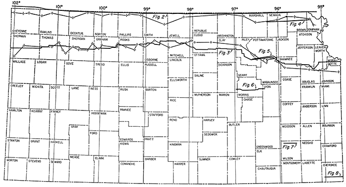
Figure 1--Index map showing location of magnetic profiles and geologic cross sections.
Geologic cross sections were constructed based on well-log data along or near lines of the magnetic profiles. Increased exploratory drilling in Kansas during the last decade has enhanced subsurface information and made possible construction of geological cross sections in almost any desired direction. Information for the cross sections was obtained from electric and radioactivity logs, sample logs, logs of the Kansas Sample Log Service, and drillers logs and scout tops.
Caution should be used in interpretation of the cross sections because of the large vertical exaggeration necessary to depict structural conditions. For example, true dip along the eastern side of the Nemaha Anticline is about 9 degrees, not 80 degrees as shown on the sections. Much structural interpretation, based on sections showing vertical exaggeration, appears less realistic when viewed in proper scale.
Magnetic profiles and geology can be compared qualitatively for the various lines of cross section but mathematical computations regarding theoretical considerations are not possible with available data. Information on such factors as magnetic susceptibilities of sedimentary rocks and the basement complex, distribution of Precambrian igneous and metamorphic rock types, and basement structure is inadequate.
The magnetic susceptibility of most rocks is directly proportional to their content of such ferromagnetic minerals as magnetite, ilmenite, pyrrhotite, and franklinite (Jakosky, 1950, p. 161). Of these ferromagnetic minerals, only magnetite is known to occur in measurable quantities in Kansas rocks. According to Stearn (1929, p. 330), the average sedimentary rock has a magnetite-ilmenite content of 0.09 percent, average granite 2.03 percent, and average basalt 6.53 percent. Locally, sedimentary rocks as well as felsic igneous rocks such as granite may have a larger percentage of ferromagnetic minerals than basic igneous rocks and thus have a higher susceptibility.
Merriam and Hambleton (1956, p. 257) discuss briefly the magnetite content of some rocks in Kansas. Precambrian granite studied by Farquhar (1957) contains less than 2 percent magnetite; the average is about 0.5 percent. Precambrian diabase encountered in Clay County contains about 2 percent magnetite. The intrusive granite at Rose Dome and the intrusive peridotite at Silver City Dome, both in Woodson County, contain less than 2 percent. No information is available on magnetite content of sedimentary rocks in the state, but some sandstone beds in the Dakota have an iron oxide content of almost 9 percent, and some of the Permo-Pennsylvanian limestone beds have an iron oxide content of 7 percent; however, iron oxide content may not be an indication of magnetic susceptibility.
Thick deposits of anhydrite, gypsum, and halite, which probably are diamagnetic, also are present in the rock column, especially in the upper Permian of western Kansas. Little is known at present concerning the effect of this blanket of diamagnetic material on the magnetic field.
Information on this profile (Fig. 2) was obtained from Jensen (1949) and Merriam and Hambleton (1956). Only the Kansas portion of a 900-mile aeromagnetic profile (Aero Service Corporation) from near Adena, Colorado, to near Indianapolis, Indiana, is reproduced here. The survey was flown approximately along the Kansas-Nebraska state line at an altitude of 3,200 to 3,450 feet. Elevation was established by subtracting mean local ground altitude from aircraft barometric altitude as corrected locally (Jensen, 1949). No correction was made for diurnal variation or instrument drift, but drift determined at the end of the flight was less than 50 gammas.
Figure 2--Magnetic profile, location of profile and well control, and geologic cross section from Doniphan County to Cheyenne County, Kansas.
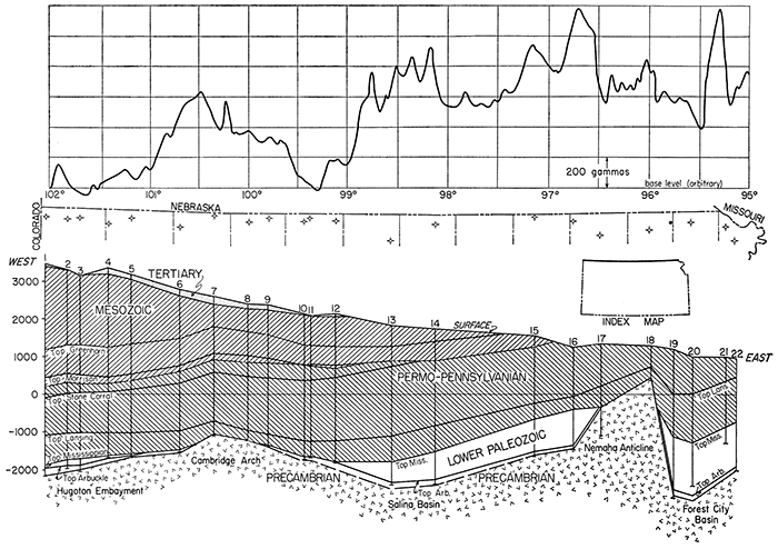
Subsurface control for the geologic cross section was obtained from 22 wells in northern Kansas. Rocks along this line of cross section range in age from Precambrian to Recent. Sedimentary rocks range in thickness from about 3,500 feet on the west at the Colorado state line (well no. 1) to 900 feet on the crest of the Nemaha Anticline (well no. 18). This thickness of sedimentary rocks is but a thin veneer over the shallow Precambrian basement complex. From west to east the cross section reveals the Hugoton Embayment, Cambridge Arch, Salina Basin, Nemaha Anticline, and Forest City Basin, all major post-Mississippian structural provinces in Kansas.
The following is a resume of the discussion of this profile by Merriam and Hambleton (1956, p. 264):
"All wells along the line of the cross section that were drilled into Precambrian encountered only granite or weathered granite.… However, additional information concerning distribution of Precambrian rock types can be obtained from Farquhar (1957). He shows that granite is present in northern Kansas, except in areas underlying the Salina basin, between parallels 97° and 99°, and in the Forest City basin, between 95° and 96°. The basement complex in these two areas, according to Farquhar, is metamorphic rock consisting of schist, phyllite, non-granitic gneiss, and crystalline limestone. Diabasic igneous rock, encountered in Clay County, is believed to extend northeastward as a narrow band into Nebraska and may intersect the cross section between wells no. 15 and 17.… This diabase probably has a high magnetic susceptibility in comparison to the other rocks. The susceptibility of the metamorphic rocks is probably higher than that of the granite.
East of the Cambridge arch, distribution of Precambrian rock types seemingly influences the magnetic profile to a considerable extent. Suggestion, therefore, is made that: (1) The local positive magnetic anomalies over the Salina basin and the Forest City basin are due mainly to the presence of metamorphic rocks of high magnetic susceptibility. (2) The pronounced positive anomaly directly west of the Nemaha anticline is produced by diabasic igneous rock. (3) The Nemaha anticline is magnetically low relative to the adjacent basins because the granite has a lower magnetic susceptibility than the metamorphic or diabasic rocks. However, superimposed on this low is a small positive anomaly caused by the nearness of the granite to the surface. Also, it may be noted that although magnetic values are relatively low over the Nemaha anticline, they are higher than magnetic values over the Cambridge arch. (4) Many of the minor irregularities that occur on the magnetic profile are due to local near-surface effects.
Because general thinning to the east of the sedimentary rock sequence, especially Mesozoic and Permo-Pennsylvanian rocks, produces a regional magnetic gradient, the magnetic values are higher in eastern than in western Kansas. In western Kansas, magnetic data seemingly indicate the position and configuration of the Precambrian surface.…"
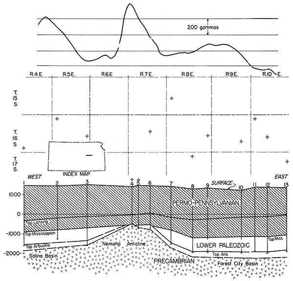
The Kansas portion of a transcontinental magnetic profile published by Woollard in 1943 is reproduced here (Fig. 3). A gravity profile accompanying the magnetic profile is not reproduced. Stations at 7-mile intervals were occupied across country from Sea Bright, New Jersey, to Morro Bay, California. Magnetic data were corrected for temperature, diurnal changes in the earth's field, and latitude. Regional corrections were also applied. The magnetic profile parallels old U. S. Highway 40.
Figure 3--Magnetic profile, location of profile and well control, and geologic cross section from Wyandotte County to Sherman County, Kansas.
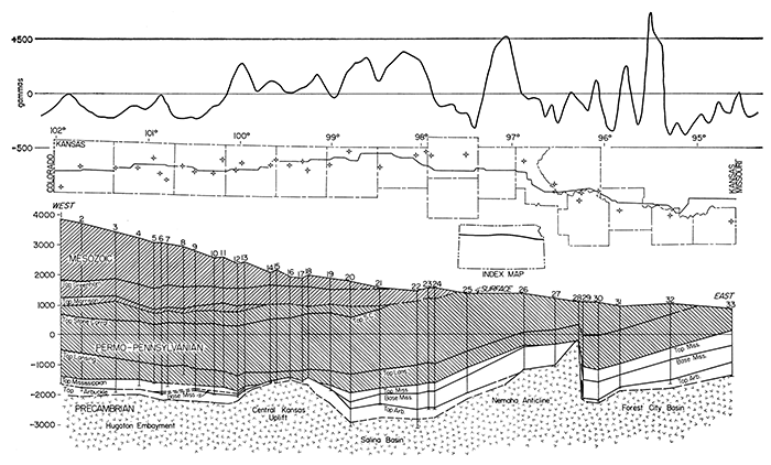
Although Woollard shows a geologic cross section, a new cross. section was prepared incorporating more recent data. Subsurface control from Wyandotte to Sherman County was obtained from 33 wells. It was not possible to show geologic detail on a cross section of this scale, but the regional relations are accurately portrayed. Along the line of cross section, rocks range in age from Precambrian to Recent; surficial rocks are not shown because of their extreme thinness in relation to scale of the section. Sedimentary rocks range in thickness from about 6,000 feet on the Colorado line (well no. 1) to about 1,000 feet over the crest of the Nemaha Anticline (well no. 28). The section crosses the Hugoton Embayment, Central Kansas Uplift, Salina Basin, Nemaha Anticline, and Forest City Basin structural provinces. The Brownville Syncline, which is the deepest part of the Forest City Basin, is revealed (in wells no. 29 and 30) just east of the Nemaha Anticline. Only a few wells along the cross section penetrated deep enough to encounter the Precambrian basement; thus configuration of the Precambrian surface is conjectural.
Following is a resume of Woollard's discussion on the Kansas portion of the profile (Woollard, 1943, p. 783):
"The western Kansas area is characterized, for the most part, by relatively strong magnetic changes with only slight local variations in the gravity values. … Most of the disturbances appear to be at a common depth as indicated by the half width value. Using the magnetic data the maximum depth to the center of mass is approximately 7.7 miles, but since the average amplitude is only 200γ they may be related to basement configuration, although this is questionable.…
However, if we may use the Nemaha Granite Ridge as a guide for this area, for the 5,000 feet of displacement there is no magnetic pattern that can definitely be correlated with it.… If the granite involved in this fault block is normal for the area the changes noted on the magnetic profile are nearly all related to changes in polarization accompanying changes in basement lithology, and not configuration effects.…
The very strong high in both sets of data … near Clay Center, Kansas, appears to be related to a very large subsurface mass that is probably gabbro. The half width value of the gravity anomaly is 12.9 miles, and that of the magnetic high 7 miles. Since this high extends from southern Kansas into Nebraska, and possibly much farther, the equations for a horizontal cylinder are applicable for computing the nature of these disturbances. On this assumption the maximum depths to the center of mass for the disturbance as indicated by the two sets of data are 13 and 14 miles respectively. If we calculate the possible position of the top of disturbance on the basis of a gabbro body in granite with a density contrast of .33 the radius of the disturbance is 34,800 feet and the depth to top 33,300 feet.…
To the east of the Nemaha Ridge … are three marked magnetic highs … there also occur weak gravity highs. Since no marked changes occur in the gravity profile, these very large magnetic changes must be related to lithologic variations other than gabbro.…"
The U. S. Geological Survey flew three aeromagnetic surveys across the Nemaha Anticline in eastern Kansas. This information was released to open file in April 1957 (Meuschke and others, 1957). The profiles are not adjusted to a common datum; no other information is available. The northernmost profile from Doniphan to Marshall County followed U. S. Highway 36 (Fig. 4).
Figure 4--Magnetic profile, location of profile and well control, and geologic cross section from Doniphan County to Marshall County, Kansas.
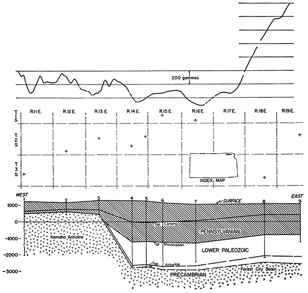
As this magnetic profile is more local than regional in character, it is on a slightly larger horizontal scale than the preceding two profiles. Subsurface control was obtained from nine wells drilled on the Nemaha Anticline and in the Forest City Basin. The wells provide adequate control for regional studies only. Thickness of the sedimentary rocks as shown by the cross section ranges from about 600 feet on the crest of the Nemaha ridge (well no. 2) to about 4,000 feet in the Forest City Basin (well no. 4). Rocks ranging in age from Precambrian to Pennsylvanian are present along the line of cross section. Surficial deposits of Quaternary age are thin and thus are not shown. As few of these wells encountered the Precambrian, configuration of the Precambrian surface is based on thickness maps of the pre-Simpson–post-Precambrian interval by Lee (1956). Relief of about 3,300 feet on the Precambrian surface (between wells 3 and 4) is evident along the eastern side of the Nemaha Anticline. This is about the maximum relief of the Precambrian surface in Kansas.
No recognizable magnetic anomaly is associated with the Nemaha Anticline. The large anomaly along the eastern side of the profile (above wells no. 8 and 9) obviously is not related to structure or configuration of the basement complex. It probably is due to near-surface causes or changes in basement lithology.
The east-west aeromagnetic profile (Fig. 5) across Pottawatomie County is another of three flown by the U. S. Geological Survey (Meuschke and others, 1957). The flight followed U. S. Highway 24 from a point just east of Manhattan to a point east of St. Marys.
Figure 5--Magnetic profile, location of profile and well control, and geologic cross section, Pottawatomie County, Kansas.
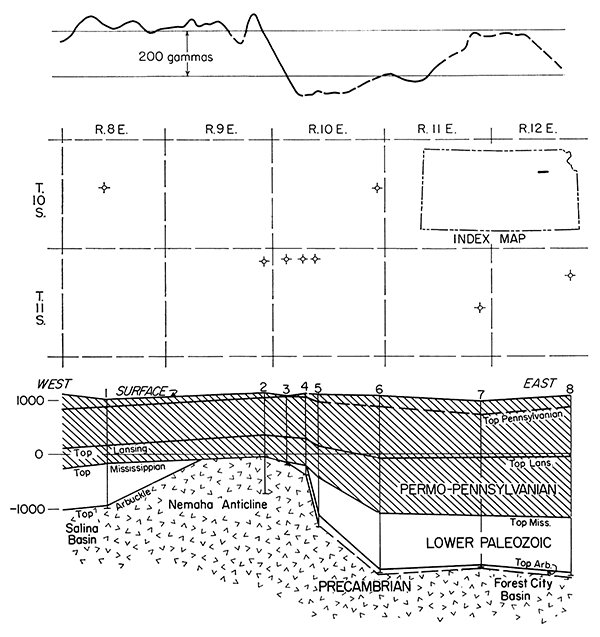
Eight wells in close proximity to the magnetic profile were used for subsurface control. The profile is local rather than regional in extent. Rocks range in age from Precambrian to Permian along the line of cross section; surficial deposits are not shown. Thickness of sedimentary rocks ranges from about 1,100 feet over the crest of the Nemaha ridge (well no. 2) to about 3,300 feet in the Forest City Basin (well no. 6). The Nemaha is revealed as an asymmetrical anticline, the east flank steeper than the west. Mississippian and older rocks on both flanks of the anticline are truncated and overstepped by Pennsylvanian beds, thus dating the major structural movement as post-Mississippian–pre-Pennsylvanian in age. Relief on the Precambrian surface is about 2,000 feet. Configuration of the Precambrian surface in the Forest City Basin was determined from isopachous maps published by Lee (1956).
The maximum difference in magnetic readings is about 200 gammas. The drop of magnetic values almost at the eastern edge of the Nemaha Anticline may indicate a fault. Several faults have been reported along the eastern side of the Nemaha Arch both in Kansas and Nebraska (Merriam, 1956, p. 95), but there is no evidence that the structure along the eastern flank is faulted in its entirety. A slight rise of about 100 feet in the basement (near well no. 7) is possibly reflected by slightly higher magnetic values. Seemingly there is fair correlation between structure or basement configuration and magnetic values along the cross section. This areal profile was flown over part of the area covered by Woollard's ground profile (Fig. 3).
This aeromagnetic profile (Fig. 6) from Lyon to Dickinson County along U. S. Highway 56 is the southernmost survey flown by the U. S. Geological Survey (Meuschke and others, 1957).
Figure 6--Magnetic profile, location of profile and well control, and geologic cross section, Lyon County to Dickinson County, Kansas.
Subsurface control was obtained from 13 wells located near the profile. Depth of the Precambrian ranges from about 1,900 feet on the crest of the Nemaha Anticline (well no. 4) to about 3,600 feet in the Forest City Basin (well no. 13). Configuration of the Precambrian surface in the Forest City and Salina Basins was determined from isopachous maps prepared by Lee (1956). Rocks along the line of cross section range in age from Precambrian to Permian; surficial deposits of Quaternary age are omitted. The Nemaha Anticline is more nearly symmetrical along this cross section than along cross sections farther north.
A magnetic anomaly of about 600 gammas occurs over the crest of the narrow Neinaha Anticline. Anomalies of lesser magnitude, both east and west of the ridge, seemingly are not connected. with structure or configuration of the basement. The anomaly in the Salina Basin may be related to the subsurface Precambrian gabbroic mass mentioned in connection with the anomaly in Clay County (Fig. 2).
The magnetic profile (Fig. 7) across northern Wilson County in T. 27 S. was constructed from an areal vertical magnetic map published by Hambleton and Merriam (1955). This east-west profile is in.the Cherokee Basin, a major post-Mississippian structural province in southeastern Kansas. Magnetic readings were corrected for diurnal variation, latitude and longitude, and annual variation.
Figure 7--Magnetic profile, location of profile and well control, and geologic cross section, Wilson County, Kansas.
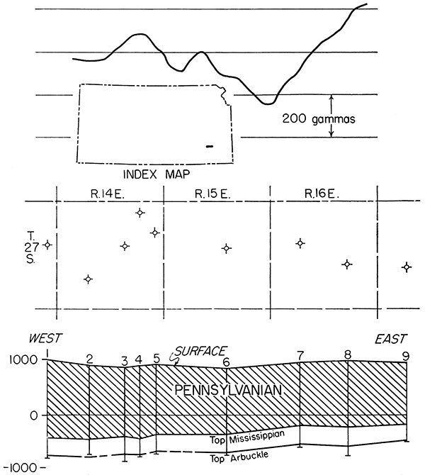
No wells encountered Precambrian rocks near the line of cross section. In fact, very few wells in southeastern Kansas have been drilled below the top of the Arbuckle, hence scanty information is available on the Precambrian. Only rocks of Arbuckle, Mississippian, and Pennsylvanian age are shown. Thickness of the incomplete sedimentary rock column shown by the cross section is about 1,800 feet.
Little correlation is evident between structure and magnetic profile; however, a magnetic low (over well no. 8) roughly corresponds to a structural high. The following is a resume of the results obtained by Hambleton and Merriam (1955, p. 125):
"Conclusions resulting from the study are premised on certain basic assumptions regarding the relation between magnetic and geologic data in this area. (1) The magnetic anomalies are produced by sandstones or shales in Pennsylvanian rocks, by igneous and metamorphic rocks of the basement complex; by intrusive igneous rocks, or by a combination of these factors.… (2) Because there is coincidence of magnetic lows with known structural highs at certain places, it is assumed that all magnetic lows reflect structural highs.… (3) Mississippian and Pennsylvanian structures, for the most part, are a reflection of basement structure.…
On the basis of these assumptions, several possibilities are suggested to account for the coincidence of magnetic lows and structural highs. (A) The anomalies are caused by basement rocks alone. Thus, a structural high would produce a magnetic low if the basement rocks exhibit inverse polarity. The possibility of variation in basement rock type, hence magnetic susceptibility, must be considered but it is evident that this factor would not be reflected in Mississippian and Pennsylvanian structures. (B) Dreyer (1947a, p. 111) reports that 'Cherokee' sandstones have a magnetic field of sufficient magnitude to account for anomalies in Crawford County, and Paul C. Franks (personal communication) reports a magnetite content as high as 8 percent for the Ireland and Tonganoxie sandstone members in this area. Thinning of such sandstones over a structural high would decrease the magnitude of the anomaly and produce, in effect, a negative anomaly. Variations in the magnetite content of these sediments could produce seemingly magnetic lows. Such variations could result from the effects of 'Cherokee' channel or beach sands. This is considered unlikely because the anomalies parallel distinct structural trends and no anomalies were evident at places where there is oil and gas production from known 'Cherokee' sands. (C) The anomalies are caused by both basement rocks and Pennsylvanian sandstones. In this event, the near-surface sedimentary rocks would tend to modify or mask the effects of the deeper basement rocks and differentiation of causes would be difficult.… The presence of intrusive igneous rocks would modify further the character of an anomaly since such rocks should produce a magnetic high.…
If no igneous rocks are involved, the anomalies may be due to the absence of magnetite-bearing sandstone. Thinning or absence in the subsurface of other Pennsylvanian rocks, such as the 'Cherokee,' may produce negative anomalies over structural highs. However, the anomalies probably are the product of both basement and sedimentary rock effects for negative anomalies do not always coincide with Mississippian or Pennsylvanian structural highs."
An east-west magnetic profile (Fig. 8) was constructed from an areal vertical magnetic map prepared by the Missouri Geological Survey (Harbaugh, 1932). The survey was made for the Missouri Survey in the Tri-State zinc and lead mining district and covered part of southeastern Kansas. The area is in the Cherokee Basin.
Figure 8--Magnetic profile, location of profile and well control, and geologic cross section, Cherokee County, Kansas.
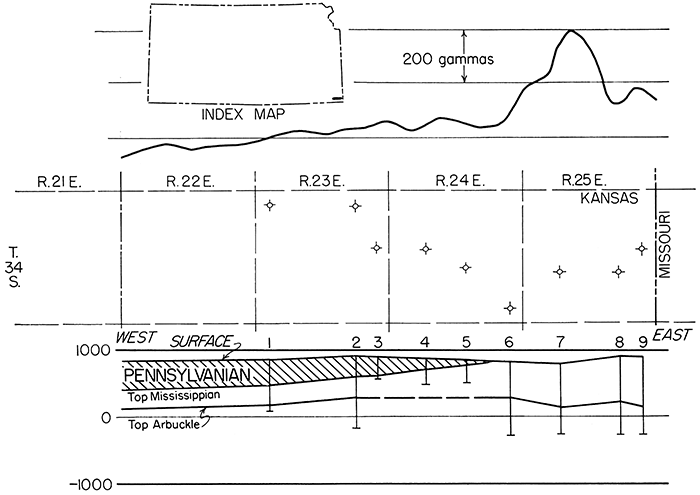
Only nine wells were used for subsurface control. Geologic information was taken from drillers logs, as no other information was available. None of the wells along or near the line of cross section encountered Precambrian rocks and no estimate of depth or configuration of the basement is possible. A thin cover of middle Pennsylvanian rocks overlies Mississippian strata, except where Mississippian rocks crop out on the extreme eastern part of the cross section near the Missouri state line. An incomplete sedimentary rock section about 1,200 feet thick is revealed by the cross section.
Gradient of the magnetic profile rises eastward, possibly corresponding to an eastward thinning of Pennsylvanian rocks. A large anomaly in R. 25 E. seemingly is associated with a structural low. Little else is evident on this local cross section.
Two of the magnetic profiles show some relation to sedimentary rock thickness: the aeromagnetic profile from Doniphan to Cheyenne County (Fig. 2) and the ground magnetic profile across Cherokee County (Fig. 8).
Merriam and Hambleton (1956) believed that thinning of Mesozoic and Permo-Pennsylvanian beds affected the aeromagnetic profile (Fig. 2), whereas thickness of Tertiary and pre-Pennsylvanian–post-Precambrian rocks seemingly had little effect on the profile. Inasmuch as both Mesozoic and Permo-Pennsylvanian rocks, and thus total section of sedimentary rocks, thin to the east, a rise in gradient of the magnetic profile results. Woollard's ground magnetic profile (Fig. 3), which encounters similar geologic conditions, does not show this corresponding rise in profile gradient, however.
Likewise, there is a gradient rise eastward corresponding to a thinning and pinching out of Pennsylvanian beds in southeastern Kansas on the east flank of the Cherokee Basin (Fig. 8). Because the profile is short, however, it is impossible to judge whether this correlation is valid.
Dreyer (1947) and Hambleton and Merriam (1955) found a local correlation between magnetic anomalies and the presence or absence of Pennsylvanian rocks in southeastern Kansas. Jenny (1932, 1941) thought he had evidence of the effect of thickening and thinning of sedimentary rocks on magnetic anomalies. He also suggested that many magnetic anomalies in areas of thick sedimentary sections, such as the Forest City Basin, were due to magnetite content of the sedimentary rocks.
The relation of magnetic anomalies to basement configuration is not evident from study of regional cross sections. In many places in Kansas, structural highs in younger sedimentary rocks reflect highs in the basement complex. Thus, the surface or configuration of basement rocks generally conforms to the overlying younger sedimentary beds. Some exceptions are Precambrian buried hills on the Central Kansas Uplift, which may not be reflected to any measureable extent by overlying beds (Walters, 1946).
A magnetic high corresponds to the structurally high Cambridge Arch (Fig. 2), but the Nemaha Anticline, showing greater relief, has no definite magnetic high associated with it. Instead, a small positive anomaly is superimposed on a negative anomaly near the crest of the structure.
Magnetic values are higher over the Central Kansas Uplift than over the Hugoton Embayment, but lower than values in the Salina Basin (Fig. 3). Magnetic values over the Salina and Forest City Basins are larger than those over adjacent uplifts, such as the Nemaha Anticline.
Little conformity of basement configuration and magnetic values can be seen on Figures 4 and 5. Figure 6 shows a magnetic high over the crest of the Nemaha Anticline, but an almost equally large anomaly occurs west of the anticline in the Salina Basin. No information is available on the Precambrian basement configuration in the Cherokee Basin (Fig. 7, 8).
Variations in magnetic values seemingly are largest over the Salina and Forest City Basins. Variations in values are smaller over the Hugoton Embayment and Cherokee Basin and over the positive elements, Central Kansas Uplift, Cambridge Arch, and Nemaha Anticline. From preliminary investigations it seems that there is little agreement between basement configuration and magnetic anomalies east of the Cambridge Arch-Central Kansas Uplift. A slight agreement of basement highs and structural highs seemingly exists in the northwestern part of the state.
Farquhar (1957) published a preliminary map on the distribution of Precambrian rock types. Most of the information obtained by Farquhar was in areas where the Precambrian is shallow, as on the Cambridge Arch, Central Kansas Uplift, and Nemaha Anticline. Some information is available on the Precambrian in basinal areas, but little is available in the deepest part of the Hugoton Embayment in southwestern Kansas where the Precambrian surface is covered by about 9,500 feet of sedimentary rock. Walters (1946) has shown by detailed subsurface work on the Central Kansas Uplift, however, that the Precambrian rock type distribution is extremely complex.
If magnetic anomalies are caused by basement rocks and if the susceptibility of granite is less than that of metamorphic rocks, then magnetic lows could be expected over uplift areas where granite prevails. Early studies (Heiland, 1929) on the configuration of Precambrian basement rocks reported lateral displacement of magnetic anomalies resulting from differences in lithology of basement rocks. As example, Heiland cites the El Dorado field, an anticlinal high in Butler County on the flank of a magnetic low, and the Gorham field in Russell County, where change in basement lithology from granite to schist produces anomalous magnetic intensities.
Jenny (1932) also found that magnetic lows correspond with structural highs at some places in central and western Kansas, and that magnetic lows coincide with structural lows and magnetic highs with structural highs in eastern Kansas. Whether or not a magnetic high would indicate a structural high then would depend on the Precambrian rock type present on the crest of the structure, if basement lithology is the dominant influence.
Jakosky, Dreyer, and Wilson (1942) in their work in southeastern Kansas determined that anomalies in that area evidently are influenced by magnetite content of basement rock and overlying sedimentary rocks, the relative effects being impossible to evaluate from magnetic work alone. Coincidence of gravity and magnetic anomalies in one area indicated that anomalies are the result of structural or lithologic variations in the Precambrian basement.
Woollard (1943) found that western Kansas is characterized by relatively large magnetic anomalies and small gravity anomalies. Most disturbances seem to be in the Precambrian at a common depth, the maximum depth of center of mass being approximately 7.7 miles. Because the Nemaha granite ridge shows no magnetic pattern that can be correlated definitely with the Precambrian basement configuration, except in Morris County (Fig. 6), the magnetic profile over the Nemaha ridge probably is related to changes in basement lithology. A strong magnetic high coinciding; with a gravity high west of the Nemaha granite ridge near Clay Center seems to be related to a large subsurface mass, probably gabbroic in composition. East of the Nemaha arch three magnetic highs that correspond with weak gravity highs may be related to lithologic variation of basement rock other than gabbro.
Merriam and Hambleton (1956) suggest that basinal areas, in general, are magnetic highs owing to the presence of Precambrian metamorphic rocks, and that basement highs are magnetic lows owing to the presence on the uplifts of granite, which is of lower magnetic susceptibility than the metamorphic rocks.
From comparison of geologic cross sections and magnetic profiles presented here, it seems that there is little correlation, with few exceptions, between structure or configuration of the basement rocks and magnetic anomalies. Thus, it may be assumed that the sources of anomalies, such as changes in basement lithology or changes in magnetic susceptibilities of the sedimentary rocks are not seen on the cross sections. As the magnetite content of the sedimentary rocks probably is small in comparsion to that of the basement rocks, and computations in connection with gravity studies indicate depth of disturbances on the order of miles, it is assumed that the anomalies are produced, or at least influenced, by Precambrian basement rock type.
We are grateful to Wallace Lee, consulting geologist, for review of the manuscript and helpful criticism.
Dreyer, R. M. (1947) Magnetic survey of southeastern Crawford County, Kansas: Kansas Geol. Survey, Bull. 70, pt. 5, p. 105-115. [available online]
Farquhar, O. C. (1957) The Precambrian rocks of Kansas: Kansas Geol. Survey, Bull. 127, pt. 3, p. 49-122. [available online]
Hambleton, W. W., and Merriam, D. F. (1955) Magnetic anomalies in Wilson and Woodson Counties, Kansas: Kansas Geol. Survey, Bull. 114, pt. 3, p.113-128. [available online]
Hambleton, W. W., and Merriam, D. F. (1957) Review of geophysical activity in Kansas through 1956: Kansas Geol. Survey, Bull. 127, pt. 1, p. 1-24. [available online]
Harbaugh, M. D. (1932) Magnetic map of Tri-State completed: Mining and Metallurgy, v. 13, no. 302, p. 86.
Heiland, C. A. (1929) Geophysical methods of prospecting: Colorado Sch. Mines Quart., v. 24, no. 1, p. 1-166.
Jakosky, J. J. (1950) Exploration Geophysics, second edition: Trija Publ. Co., Los Angeles, Calif., p. 1-1195.
Jakosky, J. J., Dreyer, R. M., and Wilson, C. H. (1942) Geophysical investigations in the Tri-State zinc and lead mining district: Kansas Geol. Survey, Bull. 44, p. 1-151. [available online]
Jenny, W. P. (1932) Magnetic vector study of regional and local geologic structure in principal oil states: Am. Assoc. Petroleum Geologists, Bull., v. 16, p. 1177-1203.
Jenny, W. P. (1941) Geological interpretations of regional magnetic anomalies in central and southern United States: Oil Weekly, v. 103, no. 3, p. 17-18, 22.
Jensen, Homer (1949) Airborne magnetic profile above 40th parallel, eastern Colorado to western Indiana: Geophysics, v. 14, no. 1, p. 57.
Lee, Wallace (1956) Stratigraphy and structural development of the Salina Basin area: Kansas Geol. Survey, Bull. 121, p. 1-167. [available online]
Merriam, D. F. (1956) History of earthquakes in Kansas; Bull. Seismological Soc. America, v. 46, no. 2, p. 87-96.
Merriam, D. F., and Hambleton, W. W. (1956) Relation of an airborne magnetic profile to the geology along the Kansas-Nebraska border: Kansas Geol. Survey, Bull. 119, pt. 7, p. 251-266. [available online]
Meuschke, Jack, and others (1957) Total intensity aeromagnetic profiles in northeastern Kansas (Nemaha ridge): U. S. Geological Survey, Open-file Rept. 57-70, plates. [available online]
Stearn, N. H. (1929) A background for the application of geomagnetics to exploration: Am. Inst. Min. Eng., Geophysical Prospecting Vol., p. 315-344.
Walters, R. F. (1946) Buried Pre-Cambrian hills in northeastern Barton County, central Kansas: Am. Assoc. Petroleum Geologists, Bull., v. 30, p. 660-710.
Woollard, G. P. (1943) Transcontinental gravitational and magnetic profile of North America and its relation to geologic structure: Geol. Soc. America, Bull., v. 54, p. 747-790.
Kansas Geological Survey
Comments to webadmin@kgs.ku.edu
Web version Nov. 25, 2013. Original publication date 1959.
URL=http://www.kgs.ku.edu/Publications/Bulletins/137/Merriam2/index.html