![]()
Prev Page--Subsurface stratigraphy || Next Page--List of wells and Bibliography
Atchison County
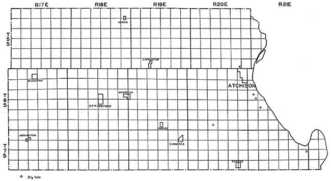
The oil and gas development in Atchison County has been very slow. This is probably due to the mantle of glacial drift and loess that covers most of the outcrops of the underlying rocks. Structures are extremely hard to map because of the lack of outcrops in the northeastern counties of Kansas. There have been only six wells drilled for oil or gas in Atchison County, two deep wells and four shallow wells. None of these have been productive, although shows of oil and gas were reported in the Oak Mills well in the NE cor. sec. 13, T. 7 S., R 21 E. The Oak Mills well was drilled by the Indian Mound Oil Company to a depth of 3,085 feet, although the log record is only to 2,890 feet. Mr. S. S. King, who furnished the log, reported about 7 feet of red rock below 2,890, 10 or 15 feet of black, dirty, sticky material, about 100 feet of what appeared to be rotten granite, and then 10 or 15 feet more of the black, dirty, sticky material. From the description of beds below 2,890 by Mr. King, it appears that the granite was encountered at about 2,900 feet. The black material probably was schist. The stratigraphic record of the Oak Mills well is given below.
| Indian Mound Oil Co. No. 1 Oak Mills, NE Cor. sec. 13, T. 7 S., R. 21 E. | Thickness in feet |
Depth in feet |
||
|---|---|---|---|---|
| Pleistocene (35 feet) | ||||
| Sand and loess | 35 | 0-35 | ||
| Pennsylvanian System | ||||
| Bronson-Lansing groups | 365 | 35-400 | ||
| Marmaton-Bourbon groups | 180 | 400-580 | ||
| Cherokee shale | 670 | 580-1,250 | ||
| Mississippian System | ||||
| "Mississippi lime" | 410 | 1,250-1,660 | ||
| Kinderhook shale | 90 | 1,660-1,750 | ||
| Silurian and Devonian Systems | ||||
| Siluro-Devonian formation | 170 | 1,750-1,920 | ||
| Ordovician System | ||||
| Maquoketa shale | 3 | 1,920-1,923 | ||
| Galena-Platteville limestone | 192 | 1,923-2,115 | ||
| St. Peter sandstone | 80 | 2,115-2,195 | ||
| Cambro-Ordovician System | ||||
| "Siliceous lime" | 635 | 2,195-2,830 | ||
| Basal sand | 60 | 2,830-2,890 | ||
| Pre-Cambrian System | ||||
| Granite and schist | 185 | 2,900?-3,085 T.D. | ||
As no samples were available from this well it is difficult to correlate the limestones between the base of the Kinderhook shale and the top of the St. Peter sandstone. The unusual thickness suggests that it cannot be entirely Galena-Platteville limestone. The upper 170 feet of the limestones are assigned to the Siluro-Devonian formation, the 3-foot shale is considered as representing the Maquoketa shale, and the lower 192 feet is regarded as Galena-Platteville limestone. Shows of gas were reported in the Oak Mills well at 574 feet, 1,400 feet, and 2,830 feet. A show of oil was reported in the basal sand at 2,830-2,890 feet.
The record of the diamond drill hole at Atchison, in the SW cor. NE sec. 18, T. 6 S., R. 21 E., is given in Bulletin 3 of the Kansas Geological Survey.v' Their correlations of this well are as follows (Moore, Raymond C., and Haynes, Winthrop: Oil and gas resources of Kansas. Kansas Geol. Survey, Bull. 3, pp. 222-224, 1917):
| Indian Mound Oil Co. No. 1 Oak Mills, NE Cor. sec. 13, T. 7 S., R. 21 E. | Thickness in feet |
Depth in feet |
|||
|---|---|---|---|---|---|
| Clay and loose rock | 18 | 18 | |||
| Pennsylvanian System: | |||||
| Douglas formation: | |||||
| Lawrence shale: | |||||
| Shale, clayey | 6 | 24 | |||
| Sandstone | 7 | 31 | |||
| Shale, blue | 33 | 64 | |||
| Sandstone | 1 | 65 | |||
| Shale, blue | 40 | 105 | |||
| Iatan limestone (?): | |||||
| Limestone (?), conglomeratic | 2 | 107 | |||
| Weston shale: | |||||
| Shale, sandy | 53 | 160 | |||
| Sandstone | 7 | 167 | |||
| Shale, blue | 9 | 176 | |||
| Sandstone | 3 | 179 | |||
| Shale, sandy | 11 | 190 | |||
| Sandstone | 34 | 224 | |||
| Limestone | 2 | 226 | |||
| Shale, blue | 8 | 234 | |||
| Sandstone | 2 | 236 | |||
| Shale, sandy | 3 | 239 | |||
| Sandstone | 5 | 244 | |||
| Lansing formation: | |||||
| Stanton limestone: | |||||
| Limestone | 20 | 264 | |||
| Sandstone | 4 | 268 | |||
| Limestone | 1 | 269 | |||
| Vilas shale: | |||||
| Sandstone | 12 | 281 | |||
| Shale, blue | 2 | 283 | |||
| Plattsburg limestone: | |||||
| Limestone | 8 | 291 | |||
| Lane shale: | |||||
| Shale, sandy | 35 | 326 | |||
| Kansas City formation: | |||||
| Iola limestone: | |||||
| Limestone | 11 | 337 | |||
| Shale, blue | 3 | 340 | |||
| Limestone | 9 | 349 | |||
| Chanute shale: | |||||
| Shale, blue and black | 4 | 353 | |||
| Limestone | 1 | 354 | |||
| Shale, blue | 9 | 363 | |||
| Limestone | 5 | 368 | |||
| Shale | 10 | 378 | |||
| Limestone | 5 | 383 | |||
| Shale, with limestone | 4 | 387 | |||
| Limestone | 1 | 388 | |||
| Shale, blue | 4 | 392 | |||
| Drum limestone (?): | |||||
| Limestone | 5 | 397 | |||
| Cherryvale shale: | |||||
| Shale | 11 | 408 | |||
| Limestone | 3 | 411 | |||
| Shale, blue | 1 | 412 | |||
| Conglomerate | 8 | 420 | |||
| Shale, blue | 7 | 427 | |||
| Conglomerate | 2 | 429 | |||
| Limestone | 6 | 435 | |||
| Conglomerate | 4 | 439 | |||
| Winterset limestone: | |||||
| Limestone | 15 | 454 | |||
| Bethany Falls limestone: | |||||
| Shale, blue | 8 | 462 | |||
| Limestone | 19 | 481 | |||
| Shale, black | 5 | 486 | |||
| Hertha limestone: | |||||
| Limestone | 16 | 502 | |||
| Marmaton formation: | |||||
| Pleasanton shale: | |||||
| Shale | 6 | 508 | |||
| Sandstone, coal, 1 inch | 5 | 513 | |||
| Shale, sandy | 6 | 519 | |||
| Limestone | 1 | 520 | |||
| Walnut shale: | |||||
| Shale, sandy | 42 | 562 | |||
| Shale, blue, clayey | 22 | 584 | |||
| Sandstone | 5 | 589 | |||
| Shale, clayey | 24 | 613 | |||
| Limestone | 1 | 614 | |||
| Bandera shale: | |||||
| Shale, clayey | 4 | 618 | |||
| Sandstone | 4 | 622 | |||
| Shale, blue, clayey | 5 | 627 | |||
| Shale, black, soft | 4 | 631 | |||
| Pawnee limestone: | |||||
| Limestone | 4 | 635 | |||
| Shale, with limestone | 8 | 643 | |||
| Shale, blue | 6 | 649 | |||
| Shale and limestone | 2 | 651 | |||
| Shale, blue | 2 | 653 | |||
| Shale and limestone | 5 | 658 | |||
| Limestone | 4 | 662 | |||
| Labette shale: | |||||
| Shale, sandy, black | 16 | 678 | |||
| Limestone | 2 | 680 | |||
| Shale, black | 2 | 682 | |||
| Coal | 1 | 683 | |||
| Shale | 2 | 685 | |||
| Fort Scott limestone: | |||||
| Shale, limy | 2 | 687 | |||
| Limestone | 5 | 692 | |||
| Shale, limy | 2 | 694 | |||
| Limestone | 3 | 697 | |||
| Shale | 10 | 707 | |||
| Limestone | 1 | 708 | |||
| Shale and limestone | 4 | 712 | |||
| Limestone | 1 | 713 | |||
| Limestone and shale | 3 | 716 | |||
| Cherokee shale: | |||||
| Shale, black, and limestone | 2 | 718 | |||
| Shale | 46 | 764 | |||
| Coal, shale partings | 1 | 765 | |||
| Sandstone and shale | 10 | 775 | |||
| Shale, coal 2 1/2 inches | 3 | 778 | |||
| Shale, sandy | 15 | 793 | |||
| Limestone, dark shaly | 6 | 799 | |||
| Coal, a little bony | 1 | 800 | |||
| Shale, with nodules | 3 | 803 | |||
| Limestone and shale | 4 | 807 | |||
| Shale, soft | 3 | 810 | |||
| Shale, sandy | 9 | 819 | |||
| No core | 4 | 823 | |||
| Limestone and shale | 5 | 828 | |||
| Shale | 7 | 835 | |||
| Coal | 1 | 836 | |||
| Shale | 15 | 851 | |||
| Sandstone | 9 | 860 | |||
| Shale, sandy | 5 | 865 | |||
| Sandstone | 1 | 866 | |||
| Shale | 12 | 878 | |||
| Coal | 1 | 879 | |||
| Shale (salty water) | 7 | 886 | |||
| Shale, sandy | 3 | 889 | |||
| Limestone and shale | 3 | 892 | |||
| Sandstone | 11 | 903 | |||
| Shale, sandy | 6 | 909 | |||
| Sandstone | 49 | 958 | |||
| Coal and shale partings, sandstone | 17 | 975 | |||
| Sandstone | 45 | 1,020 | |||
| Shale | 23 | 1,043 | |||
| Sandstone, light gray | 20 | 1,063 | |||
| Shale | 7 | 1,070 | |||
| Coal | 2 | 1,072 | |||
| Sandstone | 6 | 1,078 | |||
| Shale, light sandy | 30 | 1,108 | |||
| Shale, dark, carbonaceous | 3 | 1,111 | |||
| Sandstone, light gray | 5 | 1,116 | |||
| Shale, very dark | 1 | 1,117 | |||
| Sandstone and limestone, coal 1 inch | 4 | 1,121 | |||
| Sandstone, light colored | 1 | 1,122 | |||
| Coal | 3 | 1,125 | |||
| Sandstone | 4 | 1,129 | |||
| Shale, very dark | 4 | 1,133 | |||
| Coal | 1 | 1,134 | |||
| Sandstone | 11 | 1,145 | |||
| Shale, dark | 3 | 1,148 | |||
| Sandstone | 2 | 1,150 | |||
| Shale, coal | 2 | 1.152 | |||
| Sandstone | 12 | 1,164 | |||
| Shale, black, coal | 1 | 1,165 | |||
| Shale, carbonaceous | 0 | 0 | |||
| Shale, dark, fossiliferous | 22 | 1,187 | |||
| Coal | 2 | 1,189 | |||
| Shale, black | 7 | 1.196 | |||
| Coal, very brittle | 2 | 1,198 | |||
| Shale, dark | 57 | 1,255 | |||
| Coal | 1 | 1,256 | |||
| Sandstone, shaly | 40 | 1,296 | |||
| Shale, dark | 2 | 1,298 | |||
| Sandstone | 16 | 1,314 | |||
| Mississippian System: | |||||
| Limestone, crystalline | 38 | 1,352 | |||
There is no record of oil or gas shows in this well. The four shallow wells likewise were not productive of either oil or gas. Plate In shows the location of the wells drilled in Atchison County.
Plate III--Base map of Atchison County, showing location of wells.
Brown County
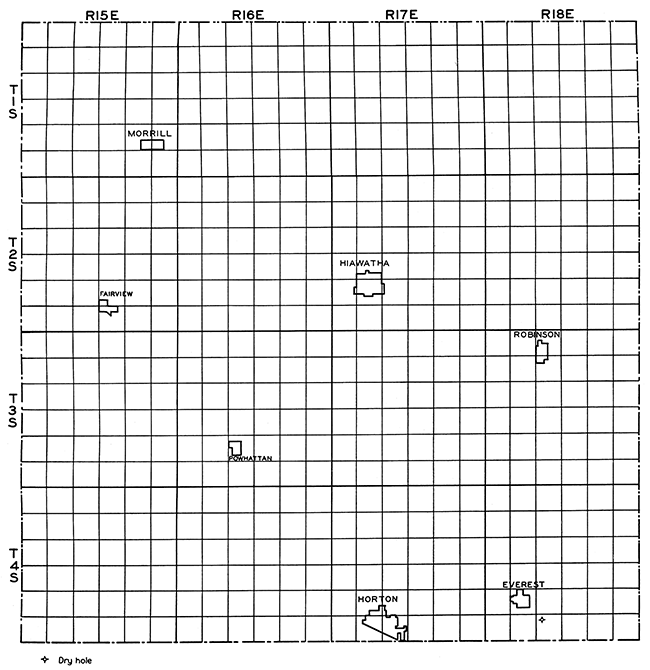
The Upper Pennsylvanian beds, including parts of the Wabaunsee and Shawnee formations, and Permian beds (in the northwestern part of the county) occur in Brown County. Outcrops of the Pennsylvanian formations are not common, however, because of the mantle of loess and glacial drift. This is the main reason why so little is known regarding subsurface structures in Brown County. The result of this inability to determine and map the structures is that there has been very little geologic work done in the county and oil and gas development has been greatly retarded. One diamond drill hole was put down at Horton in sec. 33, T. 4 S., R. 17 E., to a depth of 1,108 feet. The detailed lithology is given in Bulletin 3 of the Kansas Geological Survey (Moore, Raymond C., and Haynes, Winthrop: Oil and gas resources of Kansas. Kansas Geol. Survey, Bull. 3, pp. 228-229, 1917). Only the Pennsylvanian beds are penetrated by this well. Their correlations are as follows:
| Horton diamond drill hole, sec. 33, T. 4 S., R. 17 E. | Thickness in feet |
Depth in feet |
|||
|---|---|---|---|---|---|
| Soil | 37 | 37 | |||
| Pennsylvanian System: | |||||
| Wabaunsee formation: | |||||
| Willard shale: | |||||
| Shale, soft | 29 | 66 | |||
| Limestone | 5 | 71 | |||
| Shale, gray, hard | 14 | 85 | |||
| Burlingame limestone: | |||||
| Limestone | 3 | 88 | |||
| Shale, black, slaty | 3 | 91 | |||
| Limestone | 1 | 92 | |||
| Shale, black, slaty | 4 | 96 | |||
| Limestone | 4 | 100 | |||
| Shawnee formation: | |||||
| Scranton and Severy shales: | |||||
| Shale, gray | 3 | 103 | |||
| Shale, sandy | 7 | 110 | |||
| Shale, clayey | 18 | 128 | |||
| Limestone, black, conglomerate | 3 | 131 | |||
| Coal | 1 | 132 | |||
| Shale, clayey | 12 | 144 | |||
| Conglomerate (?) | 1 | 145 | |||
| Shale, clayey | 95 | 240 | |||
| Topeka limestone (?): | |||||
| Limestone | 2 | 242 | |||
| Shale, clayey | 18 | 260 | |||
| Limestone | 1 | 261 | |||
| Calhoun shale: | |||||
| Shale, sandy | 30 | 291 | |||
| Shale, clayey | 8 | 299 | |||
| Deer Creek limestone: | |||||
| Limestone | 3 | 302 | |||
| Shale, black, slaty | 2 | 304 | |||
| Limestone | 5 | 309 | |||
| Tecumseh shale: | |||||
| Shale, clayey | 13 | 322 | |||
| Lecompton limestone: | |||||
| Limestone | 6 | 328 | |||
| Shale, sandy | 3 | 331 | |||
| Limestone | 3 | 334 | |||
| Kanwaka shale: | |||||
| Shale, black, slaty | 9 | 343 | |||
| Shale, sandy | 2 | 345 | |||
| Shale, clayey | 6 | 351 | |||
| Douglas formation: | |||||
| Oread limestone: | |||||
| Limestone | 28 | 379 | |||
| Limestone, sandy | 4 | 383 | |||
| Lawrence shale: | |||||
| Shale, clayey | 2 | 385 | |||
| Sandstone (water) | 6 | 391 | |||
| Shale, micaceous | 5 | 396 | |||
| Shale, sandy | 43 | 439 | |||
| Shale, clayey | 20 | 459 | |||
| Iatan limestone: | |||||
| Limestone | 15 | 474 | |||
| Weston shale: | |||||
| Shale, black, slaty | 4 | 478 | |||
| Limestone | 3 | 481 | |||
| Shale, black, slaty | 1 | 482 | |||
| Limestone | 4 | 486 | |||
| Shale, hard | 6 | 492 | |||
| Shale, sandy (salt water) | 8 | 500 | |||
| Sandstone | 13 | 513 | |||
| Shale, hard | 23 | 536 | |||
| Limestone, conglomeratic | 4 | 540 | |||
| Shale, hard | 16 | 556 | |||
| Lansing formation: | |||||
| Stanton limestone: | |||||
| Limestone, sandy | 2 | 558 | |||
| Shale and limestone | 2 | 560 | |||
| Shale, hard | 3 | 563 | |||
| Limestone, conglomeratic | 2 | 565 | |||
| Limestone and shale | 23 | 588 | |||
| Vilas shale (?): | |||||
| Shale, black, slaty | 9 | 597 | |||
| Plattsburg limestone: | |||||
| Limestone | 18 | 615 | |||
| Lane shale: | |||||
| Shale; green | 14 | 629 | |||
| Shale, red | 1 | 630 | |||
| Shale, clayey | 26 | 656 | |||
| Sandstone | 4 | 660 | |||
| Shale, clayey | 23 | 683 | |||
| Shale, sandy | 2 | 685 | |||
| Shale, hard | 23 | 708 | |||
| Kansas City formation: | |||||
| Iola limestone: | |||||
| Limestone, blue | 2 | 710 | |||
| Shale, hard | 2 | 712 | |||
| Limestone, blue | 6 | 718 | |||
| Chanute and Cherryvale shales: | |||||
| Shale, red | 8 | 726 | |||
| Shale, sandy, micaceous | 4 | 730 | |||
| Shale, red | 5 | 735 | |||
| Shale, micaceous | 31 | 766 | |||
| Shale, clayey | 34 | 800 | |||
| Winterset limestone (?): | |||||
| Limestone | 5 | 805 | |||
| Galesburg shale (?): | |||||
| Shale, sandy, hard | 13 | 818 | |||
| Bethany Fans and Hertha limestones: | |||||
| Limestone, with sandy shale | 49 | 867 | |||
| Limestone | 16 | 883 | |||
| Marmaton formation (?): | |||||
| Shale clay | 16 | 899 | |||
| Limestone | 4 | 903 | |||
| Shale | 13 | 916 | |||
| Limestone | 9 | 925 | |||
| Shale | 12 | 937 | |||
| Limestone | 13 | 950 | |||
| Shale | 2 | 952 | |||
| Shale, black, slaty | 2 | 954 | |||
| Limestone, conglomerate | 2 | 956 | |||
| Shale | 7 | 963 | |||
| Limestone | 4 | 967 | |||
| Shale | 7 | 974 | |||
| Limestone | 13 | 987 | |||
| Shale | 10 | 997 | |||
| Shale, slaty and limestone | 99 | 1,096 | |||
| Limestone | 12 | 1,108 | |||
No oil and gas shows were reported in this well. Plate IV shows the location of the Horton well, Brown County.
Plate IV--Base map of Brown County, showing location of wells.
Doniphan County
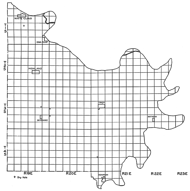
Doniphan County, in the extreme northeastern corner of Kansas, has not been tested to any extent for either oil or gas. This is probably due to two factors: First, that the structures are very difficult to map on the surface because of a thick mantle of glacial drift and loess, and secondly, that the few wells drilled were not productive and did not encourage further exploration. In 1887 a diamond drill hole was put down at Doniphan by the Diamond Prospecting Company. This well was dry and abandoned in the Cherokee shale at 998 feet. In 1917 the Southwest Oil and Gas Company drilled the Nity No. 1 well in the SE cor. sec. 19, T. 4 S., R. 21 E. This well did not reach the "Mississippi lime" as reported, but bottomed in the Cherokee shale at 1,571 feet. The Doniphan Oil and Gas Company drilled the Albers No. 1 well in the center of the SW SE sec. 14, T. 3 S., R. 19 E., to a depth of 1,725 feet in 1920 without success. The "Mississippi lime" is reported at 1,635 feet, but the limestone encountered is a limestone in the lower Cherokee and not the "Mississippi lime." A limestone hit at 1,715 may be the "Mississippi lime," but no samples are available and the determination cannot be checked.
The exact location of the Stout No. 1 well drilled in sec. 19, T. 3 S., R. 20 E., is not available, nor is the date of drilling. It was drilled to 1,500 feet and abandoned in the Cherokee shale. Stout No. 2 in the Cen. NW sec. 30, T. 3 S., R. 20 E., was drilled to 2,120 feet and abandoned. The section it penetrated is given below:
| Stout No. 2, Gen. NW sec. 30, T. 3 S., R. 20 E. | Thickness in feet |
Depth in feet |
|
|---|---|---|---|
| Pennsylvanian System: | |||
| Shawnee group | 325 | surface-325 | |
| Douglas-Pedee groups | 125 | 325-450 | |
| Bronson-Lansing groups | 375 | 450-825 | |
| Marmaton-Bourbon groups | 180 | 825-1,005 | |
| Cherokee shale | 770 | 1,005-1,775 | |
| Mississippian System: | |||
| "Mississippi lime" | 235 | 1,775-2,010 | |
| Kinderhook shale | 110 | 2.010-2.120 T.D. | |
The Valley Petroleum Company completed the John Mann well, SE NW1,4 sec. 21, T. 1 S., R. 19 E., in 1927. The well was dry and abandoned at 2,315 feet in the Siluro-Devonian formation.
| Valley Petroleum Co. No. 1 Mann, SE NW sec. 21, T. 1 S., R. 19 E. | Thickness in feet |
Depth in feet |
|
|---|---|---|---|
| Pennsylvanian System: | |||
| Shawnee group | 440 | surface-440 | |
| Douglas-Pedee groups | 200 | 440-640 | |
| Bronson-Lansing groups | 320 | 640-960 | |
| Marmaton-Bourbon groups | 170 | 960-1,130 | |
| Cherokee shale | 845 | 1,130-1,975 | |
| Mississippian System: | |||
| "Mississippi lime" | 230 | 1,975-2,205 | |
| Kinderhook shale | 76 | 2,205-2,281 | |
| Silurian and Devonian Systems: | |||
| Siluro-Devonian formation | 34 | 2,281-2,315 T.D. | |
Cuttings were not saved from this well, but the lithology of the formations is very similar to that in the W. F. Davis well near Forest City, Missouri. A complete lithologic and stratigraphic description of the Davis well is given in Volume 13 of the Missouri Bureau of Geology and Mines (Hinds, Henry, and Greene, F. C.: The stratigraphy of the Pennsylvanian series in Missouri. Missouri Bur, Geology and Mines, vol. XIII, 2d ser., pp. 215-239, 1914). The log of the Forest City well and the log of the Marysville well, Marysville, Missouri, are included in the cross-section of northeastern Kansas, Plate II (Idem, pp. 230-244). The location of the wells drilled in Doniphan County is shown on Plate V.
Plate V--Base map of Doniphan County, showing location of wells.
Douglas County
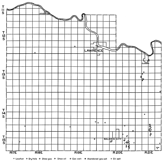
The surface rocks of Douglas County belong to the Shawnee and Douglas groups of Upper Pennsylvanian age. The eastern portion of the county is underlain with beds of the Douglas group. The western portion is occupied by beds of the Shawnee group. The escarpment of the Oread limestone formation is prominent in Douglas County. The strata in Douglas County generally dip slightly to the west, but are almost horizontal in places. Oil and gas have been found in commercial quantities in eastern and southern Douglas County, but development has been slow.
For many years there has been sporadic drilling in Douglas County, but with the exception of the Baldwin area and the Eudora area, no commercial production has been found.
The Baldwin oil field, in secs. 2, 9, 11, 12, 13, and 14, T. 15 S., R. 20 E., was opened in 1919 by a well drilled in sec. 12, T. 15 S., R. 20 E. The oil was found in sand at a depth of about 800 feet. The wells have an average initial production of about 20 barrels per day. In some wells the initial production was as high as 220 barrels per day, but the decline was rapid. Because of the small size of the wells and the relatively heavy grade of oil, activity has not been great in the Baldwin field and no pipe lines have been built. Some of the oil is used in Baldwin. The oil is found in sand at about 800-830 feet in the top of the Cherokee shales. It is probably the Squirrel sand. It averages about 20 feet in thickness. Some gas is found in the Peru sand, in the top of the Marmaton group, but this is not very important. A typical section of the Baldwin oil wells is given below.
| Webster No. 3, SE cor. NW sec. 9, T. 15 S., R. 20 E. | Thickness in feet |
Depth in feet |
|
|---|---|---|---|
| Pennsylvanian System: | |||
| Douglas-Pedee groups | 190 | 0-190 | |
| Bronson-Lansing groups | 375 | 190-565 | |
| Marmaton-Bourbon groups | 232 | 568-800 | |
| Cherokee shale | 59 | 800-859 T.D. | |
| Squirrel sand | 23 | 831-854 | |
North and east of Baldwin a small gas field has been developed. The wells found gas in the Squirrel sand at about 820 feet and ranged up to 1,000,000 cubic feet of gas per day initial production. This area has never been of great importance, however.
In northeastern Douglas County, in the vicinity of Eudora, a number of gas wells have been drilled. There are two districts of gas production in the Eudora field, one on the east side of Eudora, and the other about three miles south of Eudora. The records of the wells at Eudora show that the gas is being produced from the Peru sand, in the upper Marmaton group, at a depth of 340 feet. The sand varies considerably in thickness, one well recording 70 feet, but it probably averages about 20 feet. The wells in the district south of Eudora have an average initial production of about 500,000 cubic feet of gas per day, with an initial rock pressure of about 210 pounds. The important gas horizon in this area is the Squirrel sand, found at a depth of 700 feet. The sand averages less than 20 feet in thickness. Some gas is found in the Peru sand at a depth of 340 feet. A typical section for this area is given below.
| Hannan et al. No. 1 Bartz, NW cor. sac. 20, T. 13 S., R. 21 E. | Thickness in feet |
Depth in feet |
|
|---|---|---|---|
| Pennsylvanian System: | |||
| Bronson-Lansing groups | 340 | 0-340 | |
| Marmaton-Bourbon groups | 220 | 340-560 | |
| Cherokee shale | 125 | 560-685 T.D. | |
| Squirrel sand | 10 | 662-672 | |
There has been no recent drilling in this area, but further development can be expected as the region has not been thoroughly investigated and drilled.
Only one deep test has been drilled in Douglas County, the Al Smith et al, No. 1 Smith in the SW cor. SE sec. 28, T. 12 S., R. 19 E. It was drilled to a total depth of 2,382 feet and was abandoned. An excellent set of cuttings was obtained from this well and has served to give an accurate stratigraphic description of the well.
| Al Smith et al. No. 1 Smith, SW cor. SE sec. 28, T. 12 S., R. 19, E. | Thickness in feet |
Depth in feet |
|
|---|---|---|---|
| Pennsylvanian System: | |||
| Shawnee group | 68 | 0-68 | |
| Douglas-Pedee groups | 290 | 68-358 | |
| Bronson-Lansing groups | 337 | 358-695 | |
| Marmaton-Bourbon groups | 218 | 695-913 | |
| Cherokee shale | 558 | 913-1,471 | |
| Mississippian System: | |||
| "Mississippi lime" | 331 | 1,471-1,802 | |
| Kinderhook shale | 92 | 1,802-1,894 | |
| Ordovician System | |||
| Galena-Platteville limestone | 187 | 1,894-2,081 | |
| St. Peter sandstone | 74 | 2,081-2,155 | |
| Cambro-Ordovician System: | |||
| "Siliceous lime" | 127 | 2,155-2,382 T. D. | |
This well is included in the east-west cross-section of the Forest City Basin, Plate I.
Recent work suggests the presence of a northwest-southeast pre-Pennsylvanian structural trend which J. V. Howell has called the Iola anticline. Plate VI shows the location of the fields in Douglas County.
Plate VI--Base map of Douglas County, showing location of wells.
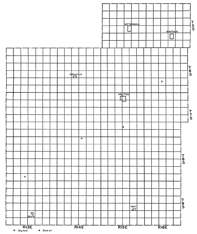
Jackson County
Jackson County lies almost entirely within the belt of outcrop of the Wabaunsee group of the Pennsylvanian. As in the neighboring counties, however, these outcrops are masked in many places by glacial drift and loess deposits so that geologic work is difficult and exploration for oil and gas has been hindered. Two attempts to secure deep oil production were made in 1928 by the Garvin et al. No. 1 Lutz well in the SW NW NW sec. 27, T. 7 S., R. 15 E., and the Goens et al. No. 1 Wabense well in the center NE NW sec. 3, T. 8 S., R. 14 E. Both wells were drilled to the Siluro-Devonian formation. The Lutz well was reported to have had a show of oil on top of the Siluro-Devonian formation at 2,639 feet, but neither well was productive of oil or gas. Three shallow wells have also been drilled in Jackson County, none of which reached the "Mississippi lime." The Charles Wheeler well, in sec. 28, T. 6 S., R. 16 E., found the Bronson-Lansing group at 775-1,095 feet and bottomed in the Marmaton at 1,200 feet. No shows of oil or gas were reported. The diamond drill hole at Hoyt, sec. 23, T. 9 S., R. 15 E., struck the Bronson-Lansing group at 978 and finished in it at 1,246 feet. The log of the well drilled to 1,000 feet at Adrian is not reliable and no definite correlation can be made for it.
The correlation of the formations penetrated by the Lutz well is given below.
| Garvin et al. No. 1 Lutz, SW NW NW sec. 27, T 7 S., R. 15 E. | Thickness in feet |
Depth in feet |
|
|---|---|---|---|
| Pennsylvanian System: | |||
| Wabaunsee group | 430 | 0-430 | |
| Shawnee group | 370 | 430-800 | |
| Douglas-Pedee groups | 215 | 800-1,015 | |
| Bronson-Lansing groups | 350 | 1,015-1,365 | |
| Marmaton-Bourbon groups | 190 | 1,365-1,555 | |
| Cherokee shale | 655 | 1,555-2,210 | |
| Mississippian System: | |||
| "Mississippi lime" | 265 | 2,210-2,475 | |
| Kinderhook shale | 164 | 2,475-2,639 | |
| Silurian and Devonian Systems: | |||
| Siluro-Devonian formation | 135 | 2,639-2,774 T.D. | |
The section penetrated by the Wabense well is very similar to that of the Lutz well and is given here for comparison.
| Goens et al. No. 1 Wabense, cen. NE NW sec. 3, T. 8 S., R. 14 E. | Thickness in feet |
Depth in feet |
|
|---|---|---|---|
| Pennsylvanian System: | |||
| Wabaunsee group | 655 | 0-655 | |
| Shawnee group | 405 | 655-1,060 | |
| Douglas-Pedee groups | 200 | 1,060-1,260 | |
| Bronson-Lansing groups | 330 | 1,260-1,590 | |
| Marmaton-Bourbon groups | 210 | 1,590-1,800 | |
| Cherokee shale | 600 | 1,800-2,400 | |
| Mississippian System: | |||
| "Mississippi lime" | 192 | 2,400-2,592 | |
| Kinderhook shale | 240 | 2,592-2,832 | |
| Silurian and Devonian Systems: | |||
| Siluro-Devonian formation | 121 | 2.832-2.953 T.D. | |
Plate VII shows the location of the wells in Jackson County. It will be noted that there has been no systematic drilling in the county. Until further careful drilling has been done one cannot predict the oil and gas possibilities of this county. The Lutz well and the Wabense well are included in the north-south cross-section through the Forest City Basin, Plate II.
Plate VII--Base map of Jackson County, showing location of wells.
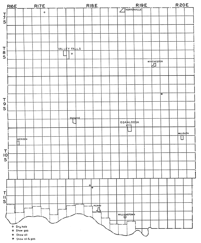
Jefferson County
Rocks of Upper Pennsylvanian age outcrop over Jefferson County, those of the Shawnee group occupying most of the county. There is considerable glacial material throughout the county, but the Pennsylvanian rocks are not covered as much as in the more northerly counties. Comparatively little structural mapping has been done in this county and oil and gas exploration has been very slow so that the oil and gas possibilities are uncertain as yet. The "Mississippi lime" has been tested by two wells with a reported showing of gas in one welL The pre-Mississippian rocks have not yielded oil or gas.
The earliest recorded well is the one at Valley Falls, located in the center of the SW NE sec. 19, T. 8 S., R. 18 E. It was drilled to a depth of 1,173 feet and abandoned. The record of this well is given in Bulletin 3, in which it is correlated according to the old Pennsylvanian classification (Moore, Raymond C., and Haynes, Winthrop: Oil and gas resources of Kansas. Kansas Geol. Survey, Bull. 3, pp. 289-290, 1917.). The section penetrated, according to the revised Pennsylvanian classification is as follows:
| Valley Falls well, cen. SW NE sec. 19, T. 8 S., R. 18 E. | Thickness in feet |
Depth in feet |
|
|---|---|---|---|
| Pennsylvanian System: | |||
| Wabaunsee group | 13 | 17-40 | |
| Shawnee group | 202 | 40-242 | |
| Douglas-Pedee groups | 258 | 242-500 | |
| Bronson-Lansing groups | 310 | 500-810 | |
| Marmaton-Bourbon groups | 169 | 810-979 | |
| Cherokee group | 194 | 979-1,173 T.D. | |
The John Freeland well, in sec. 27, T. 7 S., R. 17 E., was completed in 1921 at a depth of 1,594 feet as a dry. hole. It is reported to have hit the "Mississippi lime" at 1,590 feet. No samples from this well are available to check this correlation, but it is the writer's opinion that the "Mississippi lime" is deeper than 1,590 feet at that location.
The Winchester well, drilled by the Northern Oil and Gas Company, in the NW cor. NW sec. 13, T. 9 S., R. 19 E., was abandoned at 3,615 feet. Oil and gas shows were reported at 2,085-2,092 feet, in the St. Peter sandstone, and at 2,365-2,375 feet in the "Siliceous lime." The formations from 3,100 feet to 3,300 feet were reported to have been saturated with oil and also from 3,300 feet to 3,420 feet oil saturation and gas shows were reported. Samples from this well at 3,280, 3,390, and 3,420 feet were submitted to the Kansas Geological Survey. The cuttings from 3,280 and 3,390 feet were identified as igneous by Dr. K. K. Landes of the Survey. The sample from 3,420 was not identifiable because of its heterogeneous character. The writer believes that the pre-Cambrian surface was reached considerably above 3.280 feet. The dark "shales" and red "shales" below 3,016 strongly suggest schists of pre-Cambrian age, because the usual sequence below the "Siliceous lime" is a basal sand and then pre-Cambrian rocks. Putting the contact of the pre-Cambrian at 3,016 still leaves a very thick section of "Siliceous lime" in this welL
| Northern Oil & Gas Co. No. 1 Winchester, NW cor. NW sec. 13, T. 9 S., R. 19 E. | Thickness in feet |
Depth in feet |
|
|---|---|---|---|
| Pennsylvanian System: | |||
| Shawnee group | 245 | 0-245 | |
| Douglas-Pedee groups | 235 | 245-480 | |
| Bronson-Lansing groups | 340 | 480-820 | |
| Marmaton-Bourbon groups | 205 | 820-1,025 | |
| Cherokee shales | 595 | 1,025-1,620 | |
| Mississippian System: | |||
| "Mississippi lime" | 285 | 1,620-1,905 | |
| Kinderhook shale | 70 | 1,905-1,975 | |
| Ordovician System: | |||
| Galena-Platteville limestone | 110 | 1,975-2,085 | |
| St. Peter sandstone | 35 | 2,085-2,120 | |
| Cambro-Ordovician System: | |||
| "Siliceous lime" | 896? | 2,120-3,016? | |
| Pre-Cambrian | 3,016?-3,615 T.D. | ||
The Anderson Drilling Company recently completed two wells north of Perry, Kansas, the Stines No. 1 in the NE cor. of sec. 10, T. 11 S., R. 18 E., and the Gramse No. 1 in the SE SE sec. 4, T. 11 S., R. 18 E. The Stines No. 1 was drilled to 1,565 feet and reported an oil show in the Bartlesville sand at 1,405-1,440 feet. Correlation with the Gramse well showed that the reported "Mississippi lime" at 1,565 feet was a limestone in the lower part of the Cherokee shale about 70 feet above the top of the true "Mississippi lime." The stratigraphic section of the Stines well is given below.
| Anderson Drilling Co. No. 1 Stines, NE cor. sec. 10, T. 11 S., R. 18 E. | Thickness in feet |
Depth in feet |
|
|---|---|---|---|
| Pennsylvanian System: | |||
| Shawnee group | 279 | 0-279 | |
| Douglas-Pedee groups | 256 | 279-535 | |
| Bronson-Lansing groups | 345 | 535-880 | |
| Marmaton-Bourbon groups | 198 | 880-1,078 | |
| Cherokee shale | 487 | 1,078-1,565 T.D. | |
The Gramse well in the SE SE sec. 4, T. 11 S., R. 18 E., tested the St. Peter sandstone with no oil or gas in the pre-Mississippian formations. A strong flow of gas was reported on top of the "Mississippi lime" at 1,536 feet, but was not sufficient to be commerciaL The well found water in the St. Peter sandstone and was abandoned. The section of the Gramse well is as follows:
| Anderson Drilling Co. No. 1 Gramse, SE SE sec. 4, T. 11 S., R. 18 E. | Thickness in feet |
Depth in feet |
|
|---|---|---|---|
| Pennsylvanian System: | |||
| Shawnee group | 173 | 0-173 | |
| Douglas-Pedee groups | 252 | 173-425 | |
| Bronson-Lansing groups | 355 | 425-780 | |
| Marmaton-Bourbon groups | 194 | 780-974 | |
| Cherokee shale | 562 | 974-1,536 | |
| Mississippian System: | |||
| "Mississippi lime" | 334 | 1,536-1,870 | |
| Kinderhook shale | 75 | 1,870-1,945 | |
| Silurian and Devonian Systems: | |||
| Siluro-Devonian formation | 142 | 1,945-2,087 | |
| Ordovician System: | |||
| Maquoketa shale | 47 | 2,087-2,130 | |
| Galena-Platteville limestone | 124 | 2,130-2,254 | |
| St. Peter sandstone | 70 | 2,254-2,324 T. D. | |
There has been an increasing interest in the oil and gas development and exploration in Jefferson County. Results have been encouraging in that gas and oil shows have been reported, but no commercial wells have been brought in. Plate VIII shows the location of the wells in Jefferson County.
Plate VIII--Base map of Jefferson County, showing location of wells.
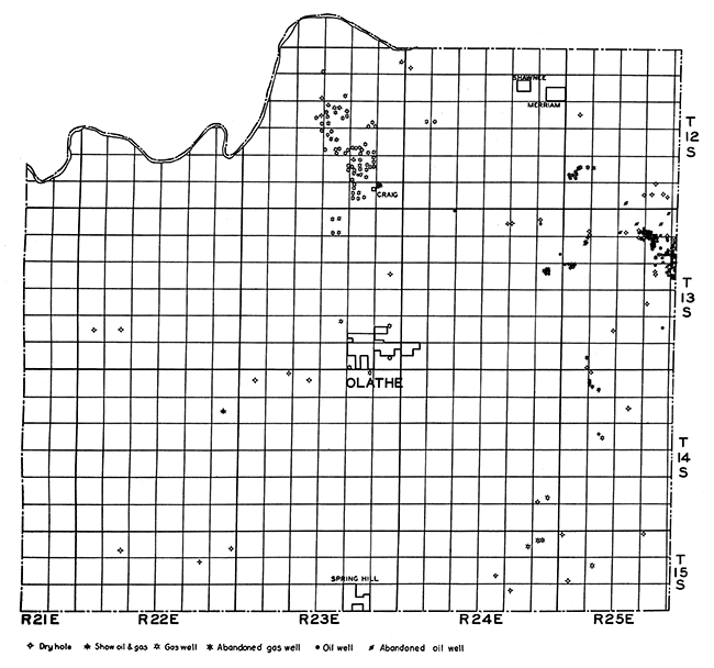
Johnson County
The surface rocks of Johnson county belong to the middle part of the Pennsylvanian system. The Douglas group outcrops in upland areas in central and western Johnson county. Beds of the Lansing group are found in the valleys. The older beds outcrop to the east, the Wyandotte and Bronson formations in the lower areas, and the Stanton limestone in prominent escarpments in eastern and southern Johnson county.
Because of the proximity of Kansas City, attempts to find oil and gas in Johnson county were made at an early date. Out of this more or less widespread drilling two definite fields have been developed, the Craig Station-Monticello gas field, and the Dallas oil and gas field. Some gas has been found northeast of Spring Hill, but a field has not been developed.
The Craig Station-Monticello field, often called the Craig field, is located in north-central Johnson county in T. 12 S., R. 23 E. Over sixty wells have been drilled in the field, but only a few are producing at the present time. A survey of the field in 1931 showed eight wells producing gas. The production of the field for 1930 was 33,785,000 cubic feet of gas. The total production of the field up to July 1, 1931, was about 3112 billion cubic feet of gas. The rock pressure has declined from 188 pounds to 34 pounds. The estimated probable gas reserves for the Craig field are about 3112 billion cubic feet. The probable gas reserves are estimated as five times the proved reserves which are figured on the decline in pressure. The gas is found in two horizons, a sand in the upper part of the Marmaton group, probably the Peru sand, and a sand in the Upper Cherokee shale, about 50 feet below the Fort Scott limestone. This lower sand is probably the Squirrel sand. The wells that produce from the Peru sand range from 150 to 300 feet in depth and the sand varies from 10 to 30 feet in thickness. The deeper wells, producing from the Squirrel sand, are 550 to 650 feet in depth. The sand averages about 25 feet in thickness. A generalized section of a typical well in the area is given below.
| Harlan et al. No. 1 Mettee, SE SW NW sec. 22, T. 12 S., R. 23 E. | Thickness in feet |
Depth in feet |
||
|---|---|---|---|---|
| Pennsylvanian System: | ||||
| Bronson-Lansing groups | 295 | 0-295 | ||
| Marmaton-Bourbon groups | 250 | 295-545 | ||
| Gas sand (Peru) | 10 | 305-315 | ||
| Fort Scott limestone | 13 | 532-545 | ||
| Cherokee shale | 105 | 545-650 T. D. | ||
| Gas sand (Squirrel) | 25 | 570-595 | ||
| Gas sand | 35 | 615-650 | ||
The location of this field is shown in Plate IX.
The Dallas oil and gas field in T. 13 S., R. 25 E., had 75 active wells in 1927, the majority producing oil and the others gas. The wells are small and the field is of minor importance. The oil is produced from the Bartlesville sand, at a depth of about 500 feet. The sand is thick and averages about 60 feet. The gas is found in a sand in the Upper Marmaton group, probably the Peru sand. The gas is not an important product of the field. Little drilling has been done in this area during the last few years.
Some shallow gas wells were drilled in sec. 1, T. 15 S., R. 24 E., but the area has not been thoroughly exploited. The wells had an initial daily production of 200,000 to 300,000 cubic feet of gas from sand in the upper part of the Marmaton group. The sand is found at a depth of 270 feet and is 20 feet thick on an average. Several tests have been drilled in T. 15 S., R. 24 E., and T. 15 S., R. 25 E., to the "Mississippi lime," with no production from the "lime," but several shows of oil were reported in the Bartlesville sand. The generalized section of one of the wells is given as typical of this area of Johnson county.
| Higgins et al. No. 1 Harrison, NW cor. sec. 6, T, 15 S., R. 25 E. | Thickness in feet |
Depth in feet |
||
|---|---|---|---|---|
| Pennsylvanian System: | ||||
| Bronson-Lansing groups | 290 | 0-290 | ||
| Marmaton-Bourbon groups | 242 | 290-532 | ||
| Gas sand (Peru) | 5 | 320-325 | ||
| Cherokee shale | 390 | 532-922 | ||
| Bartlesville sand | 10 | 772-782 | ||
| Mississippian System: | ||||
| "Mississippi lime" | 53 | 922-975 T.D. | ||
Only two deep tests have been drilled in Johnson county, one in sec. 12, T. 14 S., R. 22 E., to the granite, and another in sec. 4, T. 14 S., R. 24 E., into the "Siliceous lime." The Harrington No. 1 well was drilled to a depth of 2,236 feet by the Seminole Petroleum Company and was completed at 2,421 feet by the Universal Oil and Gas Company. The well was dry and abandoned, but shows of oil and gas were reported at the following depths:
| 270-375 Show of gas | 1,535-1,577 Show of gas |
| 673-675 Show of gas | 1,724-1,732 Show of gas |
| 712-717 Show of oil | 2,235-2,236 Show of oil and gas |
| 1,433-1,435 Show of oil |
The stratigraphic record of the Harrington well is given below.
| Universal Oil Co. No. 1 Harrington, NE cor. SW sec. 12, T. 14 S., R. 22 E. | Thickness in feet |
Depth in feet |
|
|---|---|---|---|
| Pennsylvanian System: | |||
| Bronson-Lansing groups | 340 | 0-340 | |
| Marmaton-Bourbon groups | 305 | 340-645 | |
| Cherokee shale | 380 | 645-1,025 | |
| Mississippian System: | |||
| "Mississippi lime" | 370 | 1,025-1,395 | |
| Kinderhook shale | 40 | 1,395-1,435 | |
| Ordovician System: | |||
| Galena-Platteville limestone | 100 | 1,435-1,535 | |
| St. Peter sandstone | 63 | 1,535-1,598 | |
| Cambro-Ordovician System: | |||
| "Siliceous lime" | 767 | 1,598-2,365 | |
| Cambrian System: | |||
| Basal sandstone | 35 | 2,365-2,400 | |
| Pre-Cambrian Granite | 21 | 2,400-2,421 T.D. | |
The Mahaffie well was drilled in sec. 4, T. 14 S., R. 23 E., to a depth of 1,785 feet. A small show of gas was reported at 660 feet in the Bartlesville sand. The section of the well follows:
| Mahaffie No. 1, sec. 4, T. 14 S., R. 23 E. | Thickness in feet |
Depth in feet |
|
|---|---|---|---|
| Pennsylvanian System: | |||
| Bronson-Lansing groups | 235 | 0-235 | |
| Marmaton-Bourbon groups | 265 | 235-500 | |
| Cherokee shale | 410 | 500-910 | |
| Mississippian System: | |||
| "Mississippi lime" | 405 | 910-1,315 | |
| Kinderhook shale | 20 | 1,315-1,335 | |
| Ordovician System: | |||
| Galena-Platteville limestone | 165 | 1,335-1,500 | |
| St. Peter sandstone | 65 | 1,500-1,565 | |
| Cambro-Ordovician System: | |||
| "Siliceous lime" | 220 | 1,565-1,785 T.D. | |
Johnson county will probably continue to witness intermittent drilling because of the results thus far and because of the close market Kansas City provides. Thus far attempts have failed to show any production in the pre-Pennsylvanian beds, but the few tests that have been put down are no criteria for the entire county. Plate IX shows the location of wells in Johnson county.
Plate IX--Base map of Johnson county, showing location of wells.
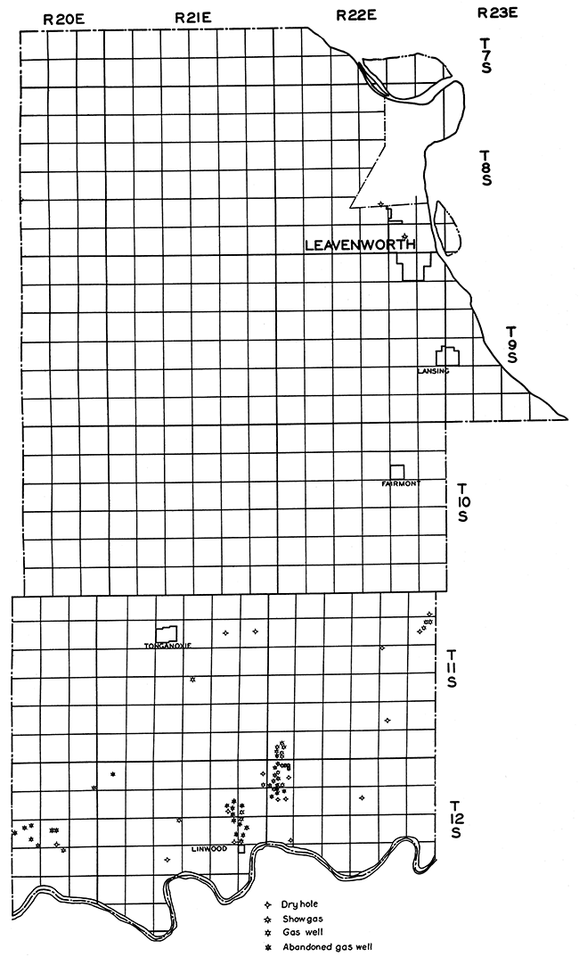
Leavenworth County
Pennsylvanian beds of Douglas and lower Shawnee age outcrop in Leavenworth county. Very little glacial drift obscures the outcrops of the Pennsylvanian rocks so that structures can be mapped fairly well throughout the county. The exploration for oil and gas has not been extensive in the northern part of the county, but there has been much mapping and gas development in southern Leavenworth county. Two gas fields have been developed in southern Leavenworth county, the Linwood gas field and the Six Corners gas field.
The Linwood gas field is located in sec. 31, T. 11 S., R. 22 E., sec. 6, T. 12 S., R. 22 E., and in sees, 11,12,13, and 14, T. 12 S., R. 21 E. The production comes from a sand about 50 feet below the Fort Scott limestone in the upper part of the Cherokee shale. It is generally known in northeastern Kansas as the Squirrel sand. The gas sand is about 700 feet below the surface and is about 20 to 30 feet in thickness throughout the field. In some of the, wells the Peru sand in the upper Marmaton group produces some gas but is not as important as the Squirrel sand. The wells in this field averaged close to 1,000,000 cubic feet of gas per day, some ranging up to 2,000,000 cubic feet of gas. The initial rock pressure was 263 pounds. There has been very little development in the Linwood field the last few years and as the pressure decreased the wells were taken off the line and abandoned.
The Six Corners gas field, located in secs. 13, 14, and 23, T. 12 S., R. 20 E., was purchased in 1927 by the Empire Oil and Refining Company for experimentation in subsurface gas storage. The gas was pumped from the lines into the ground for storage. Upon withdrawal all of the gas pumped into the sands was recovered and the success in this area led to underground storage in other regions. The gas wells in the Six Corners field were smaller initially than those in the Linwood field, although the rock pressure was slightly greater. The wells average about 500,000 cubic feet of gas per day when brought in. The production is from the Squirrel sand just below the Fort Scott limestone as in the Linwood field. The gas zone is about 750 feet in depth and is about 20 feet in thickness. Development in this field has been at a standstill, as in the Linwood area, but the prospects for increased activity in southern Leavenworth county are promising.
Two wells have been drilled to the Mississippian or deeper in Leavenworth county. A prospect well for oil and gas was drilled in 1887 at Leavenworth to a depth of 2,116 feet. No gas or oil shows were reported. The lithologic description of the well is given in the Leavenworth-Smithville folio and is correlated as follows (Hinds, Henry, and Greene, F. c.: Leavenworth-Smithville folio, Missouri-Kansas. U. S. Geol. Survey, Geol. Atlas of U. S., 1917.):
| Record of well at Leavenworth; T. 9 S, R. 23 E. | Thickness in feet |
Depth in feet |
|
|---|---|---|---|
| Quaternary System: | |||
| Loam and clay | 20 | 0-20 | |
| Pennsylvanian System | 1,155 | 20-1,175 | |
| Mississippian System: | |||
| Keokuk and Burlingame limestone | 375 | 1,175-1,550 | |
| Kinderhook (?) group | 130 | 1,550-1,680 | |
| Ordovician System: | |||
| Joachim (?) limestone | 30 | 1,680-1,710 | |
| St. Peter sandstone | 160 | 1,710-1,870 | |
| Ordovician and Cambrian | 246 | 1,870-2,116 T.D. | |
Comparison with adjacent wells has led to a partial revision of this correlation.
| Thickness in feet |
Depth in feet |
||
|---|---|---|---|
| Quaternary System | 20 | 0-20 | |
| Pennsylvanian System: | |||
| Bronson-Lansing groups | 340 | 20-360 | |
| Marmaton-Bourbon groups | 262 | 360-622 | |
| Cherokee shale | 553 | 622-1,175 | |
| Mississippian System: | |||
| "Mississippi lime" | 395 | 1,175-1,570? | |
| Kinderhook shale | 70 | 1,570?-1,650? | |
| Ordovician System: | |||
| Galena-Platteville limestone | 60 | 1,650?-1,710 | |
| St. Peter sandstone | 160 | 1,710-1,870 | |
| Cambro-Ordovician System: | |||
| "Siliceous lime" | 246 | 1,870-2,116 T.D. | |
The chief difference in the two classifications is in the Kinderhook shale. Shale only is assigned to the Kinderhook in the later classification, but since the Kinderhook is apparently becoming more limy to the east it may include some of the limestone beds as in the earlier correlation.
In 1930 Forrester et al. drilled No. 1 Yazel in the cen. E. L. SE SE sec. 18, T. 12 S., R. 22 E., in the Linwood district, to a depth of 1,546 feet where it was abandoned. The Squirrel sand, producing in that area, was absent in the Yazel well and only a few feet of Bartlesville sand were found. The stratigraphic section of the well is given below.
| Forrester et al. No. 1 Yazel, cen. E. L. SE SE sec. 18, T. 11 S., R. 22 E. | Thickness in feet |
Depth in feet |
|
|---|---|---|---|
| Pennsylvanian System: | |||
| Bronson-Lansing groups | 260 | 62-322 | |
| Marmaton-Bourbon groups | 210 | 322-532 | |
| Cherokee shale | 456 | 532-988 | |
| Mississippian System: | |||
| "Mississippi lime" | 402 | 988-1,390 | |
| Kinderhook shale | 55 | 1,390-1,445 | |
| Ordovician System: | |||
| Galena-Platteville limestone | 101 | 1.445-1.546 T.D. | |
Plate X gives the location of wells drilled in Leavenworth county and shows the location of the Linwood and Six Corners fields.
Plate X--Base map of Leavenworth county, showing location of wells.
Shawnee County
The surface rocks in Shawnee County are Upper Pennsylvanian in age. The eastern part is occupied by the Shawnee group and the western part by the Wabaunsee group. The Topeka limestone of the Shawnee group and the Burlingame limestone of the Wabaunsee group form prominent escarpments.
The first test for oil or gas in Shawnee County was drilled in 1886 at Topeka. It was a diamond drill hole, and the section as recorded in Bulletin 3 of the Kansas Geological Surveys is given below (Moore, Raymond C., and Haynes, Winthrop: Oil and gas resources of Kansas. Kansas Geol. Survey, Bull. 3, pp. 339-341, 1917.). The well was drilled to a total depth of 1,638 feet and ended in lower Cherokee shale. It was a dry hole.
| Record of well at Topeka | Thickness in feet |
Depth in feet |
|||
|---|---|---|---|---|---|
| Soil | 42 | 42 | |||
| Pennsylvanian System: | |||||
| Shawnee formation: | |||||
| Sandstone, fine, gray | 16 | 58 | |||
| Sandstone, coarse | 24 | 82 | |||
| Calhoun shale: | |||||
| Shale, blue | 19 | 101 | |||
| Shale, clay, laminated, light blue | 7 | 108 | |||
| Deer Creek limestone: | |||||
| Limestone, dark conglomerate | 3 | 111 | |||
| Limestone, mixed with clay | 12 | 123 | |||
| Shale, blue | 1 | 124 | |||
| Limestone, dark | 4 | 128 | |||
| Tecumseh shale: | |||||
| Shale, blue | 9 | 137 | |||
| Shale, laminated | 15 | 152 | |||
| Shale, blue | 2 | 154 | |||
| Lecompton limestone: | |||||
| Limestone, hard, gray | 2 | 156 | |||
| Shale, blue | 23 | 179 | |||
| Limestone, gray, fossiliferous | 5 | 184 | |||
| Kanwaka shale: | |||||
| Shale, blue, laminated | 1 | 185 | |||
| Shale | 17 | 202 | |||
| Shale, laminated, light and dark | 17 | 219 | |||
| Shale, blue (water) | 14 | 233 | |||
| Douglas formation: | |||||
| Oread limestone: | |||||
| Limestone, gray | 5 | 238 | |||
| Shale, light | 5 | 243 | |||
| Limestone, gray | 11 | 254 | |||
| Limestone, light | 1 | 255 | |||
| Shale, black | 7 | 262 | |||
| Limestone, light | 8 | 270 | |||
| Shale | 6 | 276 | |||
| Limestone, gray | 3 | 279 | |||
| Shale, hard, black | 6 | 285 | |||
| Limestone, gray | 2 | 287 | |||
| Lawrence shale: | |||||
| Shale, sand and mud | 124 | 411 | |||
| Iatan limestone: | |||||
| Limestone, crystalline | 2 | 413 | |||
| Weston shale: | |||||
| Shale | 41 | 454 | |||
| Shale | 30 | 484 | |||
| Shale, laminated, with limestone | 31 | 515 | |||
| Shale, dark, compact | 25 | 540 | |||
| Lansing formation: | |||||
| Stanton limestone: | |||||
| Limestone, light to dark, some shale | 52 | 592 | |||
| Vilas shale: | |||||
| Shale, dark, laminated | 17 | 609 | |||
| Plattsburg limestone: | |||||
| Limestone, gray | 18 | 627 | |||
| Shale, black | 3 | 630 | |||
| Limestone, gray | 6 | 636 | |||
| Shale, blue | 3 | 639 | |||
| Limestone, gray | 1 | 640 | |||
| Shale, blue | 1 | 641 | |||
| Limestone, gray | 1 | 642 | |||
| Shale, blue | 1 | 643 | |||
| Limestone, gray | 2 | 645 | |||
| Shale, blue | 3 | 648 | |||
| Lane shale: | |||||
| Shale, blue | 20 | 668 | |||
| Kansas City formation: | |||||
| Iola limestone: | |||||
| Limestone, light | 20 | 688 | |||
| Shale, soft, and mud | 11 | 699 | |||
| Limestone, gray | 13 | 712 | |||
| Chanute shale: | |||||
| Shale, dark, clayey | 12 | 724 | |||
| Limestone, gray | 7 | 731 | |||
| Shale, hard, black | 2 | 733 | |||
| Limestone, gray | 2 | 735 | |||
| Shale, dark, laminated | 12 | 747 | |||
| Drum limestone: | |||||
| Limestone, gray | 9 | 756 | |||
| Cherryvale shale: | |||||
| Shale, dark | 4 | 761 | |||
| Limestone, light and dark | 3 | 764 | |||
| Shale, dark | 10 | 774 | |||
| Limestone, light | 3 | 777 | |||
| Shale, dark | 11 | 788 | |||
| Winterset limestone (?) : | |||||
| Limestone, some shells | 23 | 811 | |||
| Shale, with limestone | 4 | 815 | |||
| Limestone, light to dark | 14 | 829 | |||
| Galesburg shale: | |||||
| Shale, laminated, dark | 6 | 835 | |||
| Limestone, conglomeratic | 3 | 838 | |||
| Shale, laminated | 2 | 840 | |||
| Limestone, conglomeratic, fossiliferous | 1 | 841 | |||
| Shale, laminated, and limestone | 13 | 854 | |||
| Bethany Falls limestone: | |||||
| Limestone, conglomeratic, fossiliferous | 12 | 866 | |||
| Shale, dark with limestone | 5 | 871 | |||
| Limestone, light gray | 7 | 878 | |||
| Ladore shale: | |||||
| Shale, black | 5 | 883 | |||
| Hertha limestone: | |||||
| Limestone | 29 | 912 | |||
| Marmaton formation: | |||||
| Pleasanton shale: | |||||
| Sandstone, gray | 3 | 915 | |||
| Shale, laminated, blue | 8 | 923 | |||
| Limestone, gray | 11 | 934 | |||
| Bandera shale: | |||||
| Shale, dark | 6 | 940 | |||
| Shale, blue | 14 | 954 | |||
| Shale, dark, clayey | 32 | 986 | |||
| 8 | 994 | ||||
| Shale, bituminous | 2 | 996 | |||
| Limestone, conglomeratic | 2 | 998 | |||
| Shale, dark, clayey | 2 | 1,000 | |||
| Pawnee limestone: | |||||
| Limestone | 3 | 1,003 | |||
| Shale, laminated | 8 | 1,011 | |||
| Limestone | 2 | 1,013 | |||
| Labette shale: | |||||
| Coal | 1 | 1,014 | |||
| Shale, laminated | 4 | 1,018 | |||
| Sandstone, laminated | 35 | 1,053 | |||
| Shale, laminated | 3 | 1,056 | |||
| Fort Scott limestone: | |||||
| Limestone | 2 | 1,058 | |||
| Shale, laminated | 5 | 1,063 | |||
| Limestone | 1 | 1,064 | |||
| Cherokee shale: | |||||
| Shale | 38 | 1,102 | |||
| Sandstone, light | 1 | 1,103 | |||
| Shale | 18 | 1,121 | |||
| Coal | 1 | 1,122 | |||
| Shale, black to light | 7 | 1,129 | |||
| Coal | 1 | 1,130 | |||
| Shale, dark to light | 10 | 1,140 | |||
| Sandstone and shale | 4 | 1,144 | |||
| Shale, black | 2 | 1,146 | |||
| Coal | 1 | 1,147 | |||
| Shale and clay, some flint | 50 | 1,197 | |||
| Coal | 1 | 1,198 | |||
| Shale and sandstone, laminated | 14 | 1,212 | |||
| Coal | 1 | 1,213 | |||
| Clay | 4 | 1,217 | |||
| Shale | 14 | 1,231 | |||
| Sandstone, micaceous | 11 | 1,242 | |||
| Shale, blue | 3 | 1,245 | |||
| Limestone, porous (gas) | 3 | 1,248 | |||
| Shale | 1 | 1,249 | |||
| Sandstone, variegated | 9 | 1,258 | |||
| Sandstone and shale | 1 | 1,259 | |||
| Shale, dark | 3 | 1,262 | |||
| Shale, little coal | 9 | 1,271 | |||
| Limestone, dark | 1 | 1,272 | |||
| 2 | 1,274 | ||||
| Shale, dark | 2 | 1,276 | |||
| Limestone, gray | 1 | 1,277 | |||
| Shale, black | 1 | 1,278 | |||
| Limestone | 1 | 1,279 | |||
| Shale, dark | 5 | 1,284 | |||
| 3 | 1,287 | ||||
| Shale, blue | 12 | 1,299 | |||
| Shale with limestone | 5 | 1,304 | |||
| Shale | 14 | 1,318 | |||
| 4 | 1,322 | ||||
| Shale, mixed with iron oxide | 3 | 1,325 | |||
| Sandstone | 9 | 1,334 | |||
| Shale, dark | 6 | 1,340 | |||
| Shale, black, little coal | 10 | 1,350 | |||
| Sandstone, little coal | 1 | 1,351 | |||
| Sandstone, hard | 1 | 1,352 | |||
| Shale, with limestone | 8 | 1,360 | |||
| Shale, clay, dark | 9 | 1,369 | |||
| Shale and sandstone | 1 | 1,370 | |||
| Sandstone, gray | 2 | 1,372 | |||
| Shale, some limestone | 8 | 1,380 | |||
| Shale, clayey, with mica sandstone | 10 | 1,390 | |||
| 3 | 1,393 | ||||
| Sandstone | 1 | 1,394 | |||
| Shale, dark | 24 | 1,418 | |||
| Sandstone, gray | 9 | 1,427 | |||
| Limestone, light | 1 | 1,428 | |||
| Sandstone, shaly | 6 | 1,434 | |||
| Sandstone, gray | 15 | 1,449 | |||
| Shale, dark | 2 | 1,451 | |||
| Sandstone, gray | 2 | 1,453 | |||
| Shale | 1 | 1,454 | |||
| Sandstone, with shale bands | 12 | 1,466 | |||
| Shale, laminated, dark | 34 | 1,500 | |||
| Sandstone and shale | 13 | 1,513 | |||
| Limestone, light | 7 | 1,520 | |||
| Shale | 9 | 1,529 | |||
| Coal | 1 | 1,530 | |||
| Shale | 67 | 1,597 | |||
| Coal | 2 | 1,599 | |||
| Limestone, crystalline | 3 | 1,602 | |||
| Shale, dark | 4 | 1,606 | |||
| Coal | 1 | 1,607 | |||
| Sandstone and shale | 3 | 1,610 | |||
| Shale | 11 | 1,621 | |||
| Sandstone, white | 4 | 1,625 | |||
| Shale, dark | 13 | 1,638 | |||
Since 1886 fourteen wells have been drilled, of which nine encountered pre-Pennsylvanian beds. All of the wells were dry and were abandoned. All of the earliest tests stopped before they reached the "Mississippi lime." The first test to reach the "Mississippi lime" was the Wapeka Oil Company's No. 1 Neil in the cen. SW NE sec. 26, T. 13 S., R. 15 E., drilled in 1917. It topped the "Mississippi lime" at 1,545 feet and was drilled to a total depth of 2,430 feet.
In 1920 the Advance Oil and Refining Company drilled No. 1 Shawnee in the SW NW sec. 14, T. 10 S., R. 13 E., to a depth of 2,700 feet. The stratigraphic section of this well is given below.
| Advance Oil & Refining Co. No. 1 Shaumee, SW NW sec. 14, T. 10 S., R. 13 E. | Thickness in feet |
Depth in feet |
|
|---|---|---|---|
| Pennsylvanian System: | |||
| Wabaunsee group | 360 | 0-360 | |
| Shawnee group | 410 | 360-770 | |
| Douglas-Pedee groups | 220 | 770-990 | |
| Bronson-Lansing groups | 345 | 990-1,335 | |
| Marmaton-Bourbon groups | 165 | 1,335-1,500 | |
| Cherokee shale | 615 | 1,500-2,115 | |
| Mississippian System: | |||
| "Mississippi lime" | 200 | 2,115-2,315 | |
| Kinderhook shale | 247 | 2,315-2,562 | |
| Silurian and Devonian Systems: | |||
| Siluro-Devonian formation | 138 | 2.562-2.700 T.D. | |
Sulphur water was found in the Siluro-Devonian formation and the well was abandoned. This well is included in the north-south section through the Forest City basin, Plate II.
Green et al. drilled the No. 1 Ripley well in the NW cor. NE~ sec. 12, T. 12 S., R. 16 E., in 1923 and struck the pre-Cambrian granite at 3,015 feet, penetrating it for 305 feet to a depth of 3,320 feet. No shows of oil or gas were reported. The stratigraphic record of this well follows:
| Green et al. No. 1 Ripley, NW cor. NE sec. 12, T. 12 S., R. 16 E. | Thickness in feet |
Depth in feet |
|
|---|---|---|---|
| Pennsylvanian System: | |||
| Shawnee group | 325 | 0-325 | |
| Douglas-Pedee groups | 275 | 325-600 | |
| Bronson-Lansing groups | 350 | 600-950 | |
| Marmaton-Bourbon groups | 240 | 950-1,190 | |
| Cherokee shale | 590 | 1,190-1,780 | |
| Mississippian System: | |||
| "Mississippi lime" | 270 | 1,780-2,050 | |
| Kinderhook shale | 90 | 2,050-2,140 | |
| Silurian and Devonian Systems: | |||
| Siluro-Devonian formation | 120 | 2,140-2,260 | |
| Ordovician System: | |||
| Maquoketa shale | 20 | 2,260-2,280 | |
| Galena-Platteville limestone | 125 | 2,280-2,405 | |
| St. Peter sandstone | 70 | 2,405-2,475 | |
| Cambro-Ordovician System: | |||
| "Siliceous lime" | 530 | 2,475-3,005 | |
| Cambrian System: | |||
| Basal sandstone | 10 | 3,005-3,015 | |
| Pre-Cambrian System: | |||
| Granite | 305 | 3,015-3,320 T.D. | |
The Ripley well is one of the wells in the east-west section through the Forest City Basin, Plate 1. It will be noted that, although the Siluro-Devonian formation and Maquoketa shale are present in the Ripley well, they are absent in the Smith et al. No. 1 Smith well to the east. These beds were truncated in the pre-Mississippian erosion intervaL
The Onarch Oil and Gas Co. No. 1 Omar Allen well in the SE cor. NE NW sec. 2, T. 11 S., R. 14 E., was drilled in 1929 to the Siluro-Devonian formation, 2,450-2,471 feet, and found sulphur water. It was abandoned at 2,471 feet.
Two deep tests were drilled near Topeka and a third started but abandoned. Hummer No. 1 drilled by Forrester et al., in the center of the SW sec. 14, T. 11 S., R. 16 E., was drilled to the granite and abandoned at 3,023 feet. Samples were carefully saved and the stratigraphic section was accurately determined.
| Forrester et al. No. 1 Hummer, cen. SW sec. 14, T. 11 S., R. 16 E. | Thickness in feet |
Depth in feet |
|
|---|---|---|---|
| Pennsylvanian System: | |||
| Shawnee group | 355 | 0-355 | |
| Douglas-Pedee groups | 275 | 355-630 | |
| Bronson-Lansing groups | 345 | 630-975 | |
| Marmaton-Bourbon groups | 245 | 975-1,220 | |
| Cherokee shale | 565 | 1,220-1,785 | |
| Mississippian System: | |||
| "Mississippi lime" | 255 | 1,785-2,040 | |
| Kinderhook shale | 120 | 2,040-2,160 | |
| Silurian and Devonian Systems: | |||
| Siluro-Devonian formation | 120 | 2,160-2,280 | |
| Ordovician System: | |||
| Maquoketa shale | 50 | 2,280-2,330 | |
| Galena-Platteville limestone | 120 | 2,330-2,450 | |
| St. Peter sandstone | 100 | 2,450-2,550 | |
| Cambro-Ordovician System: | |||
| "Siliceous lime" | 440 | 2,550-2,990 | |
| Cambrian System: | |||
| Basal sandstone | 20 | 2,990-3,010 | |
| Pre-Cambrian System: | |||
| Granite | 13 | 3,010-3,023 T.D. | |
The Hummer well found a hole full of water in the Siluro-Devonian formation and in the St. Peter sandstone. The well is included in the east-west section through the Forest City Basin, Plate I.
The second deep test near Topeka was Jenkins and Scott No. 1 Hayden in the NE NE SE sec. 8, T. 12 S., R. 14 E. This well reported showings of gas at 715, 1,180-1,225, and 1,665-1,710 feet, but no commercial quantities were found. The formations are relatively thick below the Pennsylvanian, showing a synclinal condition that did not favor oil accumulation in the pre-Pennsylvanian beds. The well was abandoned in the Simpson formation at 2,693 feet.
| Jenkins and Scott No. 1 Hayden, NE NE SE sec. 8, T. 12 S., R. 14 E. | Thickness in feet |
Depth in feet |
|
|---|---|---|---|
| Pennsylvanian System: | |||
| Wabaunsee group | 150 | 0-150 | |
| Shawnee group | 382 | 150-532 | |
| Douglas-Pedee groups | 263 | 532-795 | |
| Bronson-Lansing groups | 345 | 795-1,140 | |
| Marmaton-Bourbon groups | 170 | 1,140-1,310 | |
| Cherokee shale | 565 | 1,310-1,875 | |
| Mississippian System: | |||
| "Mississippi lime" | 295 | 1,875-2,170 | |
| Kinderhook shale | 150 | 2,170-2,320 | |
| Silurian and Devonian Systems: | |||
| Siluro-Devonian formation | 125 | 2,320-2,445 | |
| Ordovician System: | |||
| Maquoketa shale | 77 | 2,445-2,522 | |
| Galena-Platteville limestone | 133 | 2,522-2,655 | |
| St. Peter sandstone | 38 | 2,655-2,693 T. D. | |
The Hayden well is included in the east-west section across the Forest City Basin, Plate 1. The thickening of the beds below the Pennsylvanian can readily be seen.
Jenkins and Scott started the Asherman well in the NE NW NE sec. 28, T. 10 S., R. 15 E., but abandoned it at 862 feet.
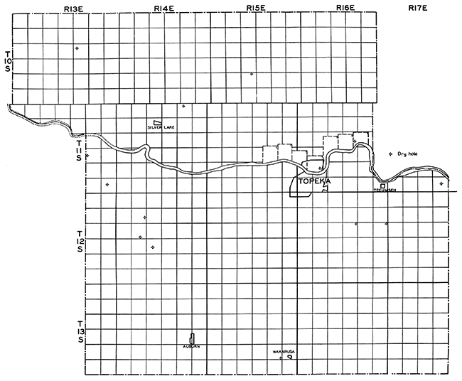
Results in oil and gas exploration have been disappointing, but there is much territory in Shawnee County left for investigation. What the future for oil and gas development in Shawnee County is cannot be predicted, but the county cannot be condemned by the scattered drilling attempts up to the present time. Plate XI shows the location of the wells in Shawnee County.
Plate XI--Base map of Shawnee County, showing location of wells.
Wabaunsee County
Pennsylvanian and Permian rocks appear at the surface in Wabaunsee County, the Lower Permian beds in the western and southwestern part of the county and Upper Pennsylvanian beds of the Wabaunsee group in the eastern and central part of the county. The general dip of the strata is westward, but anticlinal structures have been mapped in the county. The structure near Alma is an anticline whose crest is 160 feet above the bottom of the adjacent shallow anticline to the east (51. Moore, Raymond C, and Haynes, Winthrop P.: Oil and gas resources of Kansas. Kansas Geol. Survey, Bull. 3, p. 346, 1917). This structure was tested by a diamond drill hole in the SW cor. of sec. 31, T. 11 S., R. 11 E., near McFarland, which did not show any oil or gas. The McFarland well stopped in the Cherokee shale at 2,006 feet. The Upper Pennsylvanian beds are hard to correlate from the record of this well, but the Douglas-Pedee groups can be identified from 880 to 1,151 feet, the Bronson-Lansing group from 1,151 to 1,536 feet, the Marmaton group from 1,536 to 1,842 feet, and the Cherokee shale from 1,842 to 2,006 feet.
Three wells drilled in Wabaunsee County reached the pre-Cambrian basement rocks. The Parker Oil Company drilled two wells on the Bardwell farm. The record of Bardwell No. 2, sec. 26, T. 10 S., R. 9 E., as given in Bulletin 3 of the Kansas Geological Survey, follows (52. Idem, p. 151):
| Record of Bardwell well No. 2, Zeandale, Wabaunsee County | Thickness in feet |
Depth in feet |
|---|---|---|
| Soil and clay | 10 | 10 |
| Clay, soft | 20 | 30 |
| Sand, fine | 10 | 40 |
| Clay, blue | 20 | 60 |
| Gravel, coarse | 6 | 66 |
| Clay, blue | 17 | 83 |
| Limestone | 2 | 85 |
| Shale, light blue | 80 | 165 |
| Limestone | 4 | 169 |
| Shale, blue | 88 | 257 |
| Limestone | 26 | 283 |
| Shale, light | 12 | 295 |
| Shale, sandy | 10 | 305 |
| Shale | 15 | 320 |
| Limestone | 43 | 363 |
| Shale | 10 | 373 |
| Limestone | 5 | 378 |
| Shale | 12 | 390 |
| Limestone | 8 | 398 |
| Shale, black | 2 | 400 |
| Limestone | 25 | 425 |
| Shale | 50 | 475 |
| Limestone | 5 | 480 |
| Shale, light | 5 | 485 |
| Limestone | 24 | 509 |
| Shale | 1 | 510 |
| Limestone | 15 | 525 |
| Clay | 5 | 530 |
| Limestone | 4 | 534 |
| Shale, blue | 76 | 610 |
| Limestone | 5 | 615 |
| Shale | 5 | 620 |
| Redrock | 2 | 622 |
| Shale | 3 | 625 |
| Limestone | 8 | 633 |
| Shale, light | 25 | 658 |
| Limestone | 7 | 665 |
| Shale | 4 | 669 |
| Limestone | 1 | 670 |
| Shale | 2 | 672 |
| Limestone | 1 | 673 |
| Shale | 1 | 674 |
| Limestone | 19 | 693 |
| Shale, blue | 3 | 696 |
| Limestone | 1 | 697 |
| Shale | 3 | 700 |
| Limestone | 5 | 705 |
| Shale | 5 | 710 |
| Limestone | 18 | 728 |
| Shale | 3 | 731 |
| Limestone | 4 | 735 |
| Shale, light | 8 | 743 |
| Limestone | 40 | 783 |
| Shale | 1 | 784 |
| Limestone | 10 | 794 |
| Shale | 2 | 796 |
| Limestone | 26 | 822 |
| Shale, light | 4 | 826 |
| Limestone | 2 | 828 |
| Shale | 2 | 830 |
| Limestone | 35 | 865 |
| Shale | 4 | 869 |
| Limestone | 4 | 873 |
| Shale | 2 | 875 |
| Limestone | 8 | 883 |
| Shale | 2 | 885 |
| Limestone | 15 | 900 |
| Shale | 4 | 904 |
| Limestone | 49 | 953 |
| Shale | 5 | 958 |
| Granite, gray | 17 | 975 |
| Granite, red | 15 | 990 |
| Shale | 1 | 991 |
| Granite, gray | 102 | 1,093 |
The above record shows the top of the granite at 958 feet. The well was drilled to a depth of 1,093 feet and abandoned. Pink, medium to fine-grained granite and chlorite schists are reported to have been penetrated by the Bardwell well. This well is often known as the Zeandale well because of its location near Zeandale.
The Empire Oil and Refining Company No. 1 Root well in the cen. SW NE sec. 1, T. 11 S., R. 9 E., struck the granite surface at 1,180 feet and drilled 820 feet into it to a total depth of 2,000 feet. Pink, medium to fine-grained granite is reported from this well. A record of this well and a description of the granite cuttings are given in Bulletin 3 of the Kansas Geological Survey (53. Op. cit. pp. 150, 163). The record follows:
| Record of well south of Wabaunsee, Wabaunsee County | Thickness in feet |
Depth in feet |
|---|---|---|
| Shale | 90 | 90 |
| Limestone | 20 | 110 |
| Shale, black | 5 | 115 |
| Shale, light | 10 | 125 |
| Shale, black | 40 | 165 |
| Sandstone | 30 | 195 |
| Sand (water) | 23 | 218 |
| Limestone | 92 | 310 |
| Shale | 10 | 320 |
| Limestone | 30 | 350 |
| Sandstone | 30 | 380 |
| Shale (little gas) | 15 | 395 |
| Limestone | 26 | 421 |
| Shale | 39 | 460 |
| Limestone | 24 | 484 |
| Shale | 20 | 504 |
| Limestone | 2 | 506 |
| Sandstone | 16 | 522 |
| Shale | 20 | 542 |
| Limestone | 38 | 580 |
| Shale | 6 | 586 |
| Limestone | 6 | 592 |
| Shale | 36 | 628 |
| Limestone | 4 | 632 |
| Redrock | 20 | 652 |
| Shale | 6 | 658 |
| Sandstone | 17 | 675 |
| Shale | 60 | 735 |
| Limestone | 70 | 805 |
| Shale | 65 | 870 |
| Limestone | 102 | 972 |
| Shale | 13 | 985 |
| Limestone | 6 | 991 |
| Shale and coal | 95 | 1,086 |
| Limestone | 29 | 1,115 |
| Shale | 5 | 1,120 |
| Shale and flint | 60 | 1,180 |
| Granite, red | 200 | 1,380 |
| Granite, gray | 80 | 1,460 |
| Granite, red | 20 | 1,480 |
| Granite, gray | 510 | 1,990 |
Both the Root well and the Bardwell well were about on the crest of the Nemaha granite ridge. Figure 3 shows the location of the ridge and its relationship to the Forest City Basin to the east.
The Williams et al, No. 1 Henderson well in the cen. NE sec. 15, T. 13 S., R. 12 E., begun in 1924 and finished in 1928, was drilled to a total depth of 3,652 feet and encountered granite at 3,625 feet. The steep eastward slope of the granite ridge is illustrated by these wells. The granite in the Root well is approximately 55 feet below sea level, while the granite in the Henderson well, 21 miles southeast of the Root well, is approximately 2,455 feet below sea level, a difference of 2,400 feet. The Henderson test is located well out into the Forest City Basin.
The Empire Oil and Refining Co. No. 1 Schwalm well in the SE cor. sec. 19, T. 12 S., R. 11 E., was drilled to a depth of 3,431 feet and an excellent set of cuttings was saved. A careful study of these cuttings has made accurate correlation possible. The section of the. Schwalm well is, therefore, a very good type section for Wabaunsee County. The well is in the lowest part of the Forest City Basin for, in spite of its depth of 3,431 feet, it reached only the St. Peter sandstone. The section of the Schwalm well is given below.
| Empire Oil & Refining Co. No. 1 Schwalm, SE cor. sec. 19, T. 12 S., R. 11 E. | Thickness in feet |
Depth in feet |
|
|---|---|---|---|
| Permian System: | |||
| Council Grove group | 295 | 0-295 | |
| Pennsylvanian System: | |||
| Wabaunsee group | 605 | 295-900 | |
| Shawnee group | 355 | 900-1,255 | |
| Douglas-Pedee groups | 240 | 1,255-1,495 | |
| Bronson-Lansing groups | 355 | 1,495-1,850 | |
| Marmaton-Bourbon groups | 220 | 1,850-2,070 | |
| Cherokee shale | 415 | 2,070-2,485 | |
| Mississippian System: | |||
| "Mississippi lime" | 320 | 2,485-2,805 | |
| Kinderhook shale | 185 | 2,805-2,990 | |
| Silurian and Devonian Systems: | |||
| Siluro-Devonian formation | 225 | 2,990-3,215 | |
| Ordovician System: | |||
| Maquoketa shale | 70 | 3,215-3,285 | |
| Galena-Platteville limestone | 115 | 3,285-3,400 | |
| St. Peter sandstone | 31 | 3,400-3,431 | |
No shows of oil or gas were reported in this well. The Schwalm well is included in the east-west cross-section, Plate 1.
The Ramsey Petroleum Company No. 1 Kaul well in the SW NE NE sec. 2, T. 11 S., R. 11 E., was drilled to the Siluro-Devonian formation, but found no oil or gas. The well went to 2,830 feet. The section of this well is as follows:
| Ramsey Petroleum Co. No. 1 Kaul, SW NE NE sec. 2, T. 11 S. R. 11 E. | Thickness in feet |
Depth in feet |
|
|---|---|---|---|
| Pennsylvanian System: | |||
| Wabaunsee groups | 560 | 0-560 | |
| Shawnee group | 410 | 560-970 | |
| Douglas-Pedee groups | 200 | 970-1,170 | |
| Bronson-Lansing groups | 355 | 1,170-1,525 | |
| Marmaton-Bourbon groups | 223 | 1,525-1,748 | |
| Cherokee shale | 492 | 1,748-2,240 | |
| Mississippian System: | |||
| "Mississippi lime" | 135 | 2,240-2,375 | |
| Kinderhook shale | 210 | 2,375-2,585 | |
| Silurian and Devonian Systems: | |||
| Siluro-Devonian formation | 245 | 2,585-2,830 T.D. | |
A discussion of the lower section is given by F. C. Edson in which the Kinderhook beds are described in detail (Edson, F. C.: Pre-Mississippian sediments in central Kansas. Am. Assoc. Petroleum Geologists, Bull., vol. 13, No. 5, pp. 442-443, 1929). The top of the Kinderhook shale was a bed of soft, light pinkish-gray shale about 15 feet in thickness. Below this was a light greenish-gray shale which carried Sporangites huronense from 2,445 to 2,580 feet. Banded reddish-brown and greenish-gray shale at the base, 2,580- 2,585 feet, carried these plant spores also. The dolomitic limestone below the Kinderhook shale, identified as Siluro-Devonian by the writer, was described by Edson as a cream-colored dolomitic limestone from 2,585 to 2,620 feet, passing into a 10-foot zone of white and gray semitranslucent chert, and then cream to buff finely crystalline pure dolomite. Edson describes the lowest sample which she examined, at 2,650 feet, as containing a small amount of irregular subangular, frosted sand. No age is assigned to this dolomite by Mrs. Edson.
Three other wells drilled in Wabaunsee County reached the "Mississippi lime." The Kansas Oil Association No. 1 Wille well in the cen. SW NE sec. 5, T. 11 S., R. 11 E., was drilled to 2,700 feet and reported a showing of oil and gas in sand at 2,000 to 2,024 feet, but was abandoned. The section of this well is as follows:
| Kansas Oil Association No. 1 Wille, cen. SW NE sec. 5, T. 11 S., R. 11 E. | Thickness in feet |
Depth in feet |
|
|---|---|---|---|
| Permian System: | |||
| Council Grove group | 290 | 0-290 | |
| Pennsylvanian System: | |||
| Wabaunsee group | 450 | 290-740 | |
| Shawnee group | 385 | 740-1,125 | |
| Douglas-Pedee groups | 200 | 1,125-1,325 | |
| Bronson-Lansing groups | 370 | 1,325-1,695 | |
| Marmaton-Bourbon groups | 180 | 1,695-1,875 | |
| Cherokee shale | 420 | 1,875-2,295 | |
| Mississippian System: | |||
| "Mississippi lime" | 185 | 2,295-2,480 | |
| Kinderhook shale | 220 | 2,480-2,700 T.D. | |
The American Petroleum Corporation drilled a well on the Schmidt farm in the cen. SE SE sec. 9, T. 12 S., R. 10 E., to a depth of 2,339 feet and was abandoned. It penetrated the following formations:
| American Petroleum Corporation No. 1 Schmidt, cen. SE SE sec. 9, T. 12 S., R. 10 E. | Thickness in feet |
Depth in feet |
|
|---|---|---|---|
| Permian System: | |||
| Council Grove group | 270 | 0-270? | |
| Pennsylvanian System: | |||
| Wabaunsee group | 490 | 270?-760 | |
| Shawnee group | 350 | 760-1,110 | |
| Douglas-Pedee groups | 200 | 1,110-1,310 | |
| Bronson-Lansing groups | 365 | 1,310-1,675 | |
| Marmaton-Bourbon groups | 200 | 1,675-1,875 | |
| Cherokee shale | 395 | 1,875-2,270 | |
| Mississippian System: | |||
| "Mississippi lime" | 69 | 2,270-2,339 T.D. | |
A well drilled in the NW SE SE of sec. 9, T. 12 S., R. 10 E., the Coleman-Edgerton No. 1-B Smith, produced 44,000 cubic feet of helium gas in sand at 266 to 276 feet. This is very unusual and is the only recorded well in northeastern Kansas producing helium gas. No attempt has been made to develop this helium gas area by further drilling.
Another deep test in Wabaunsee County was the Steinmeyer No. 1 well drilled by the Manhattan Oil Company in the NE NW SW sec. 11, T. 13 S., R. 10 E. This well was drilled to a depth of 2,405 feet and found a hole full of water in the "Mississippi lime." The record of this well is given below.
| Manhattan Oil Company No. 1 Steinmeyer, NE cor. NW SW sec. 11, T. 13 S., R. 10 E. | Thickness in feet |
Depth in feet |
|
|---|---|---|---|
| Permian System: | |||
| Council Grove group | 195 | 0-195 | |
| Pennsylvanian System: | |||
| Wabaunsee group | 590 | 195-785 | |
| Shawnee group | 375 | 785-1,160 | |
| Douglas-Pedee groups | 205 | 1,160-1,365 | |
| Bronson-Lansing groups | 370 | 1,365-1,735 | |
| Marmaton-Bourbon groups | 210 | 1,735-1,945 | |
| Cherokee shale | 395 | 1,945-2,340 | |
| Mississippian System: | |||
| "Mississippi lime" | 65 | 2,340-2,405 T.D. | |
The log of this well is included in the east-west cross-section in Plate I.
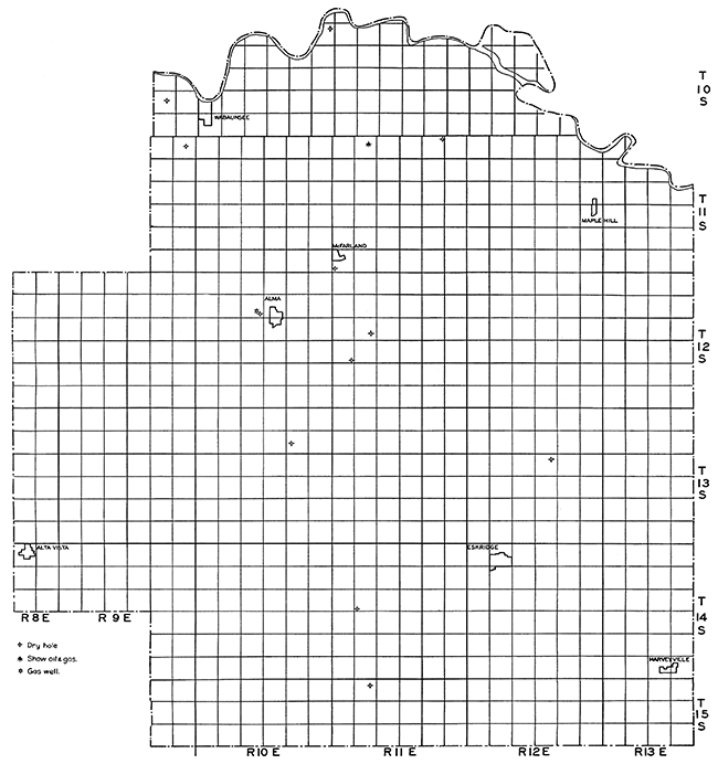
The exploration and development of oil and gas in Wabaunsee County has been slow up to the present time. This is due in a large part to the disappointing results of the wells that have been drilled. With the exception of a few shows of oil and gas, the only productive well is the Smith No. 1-B in sec. 9, T. 12 S., R. 10 E., which produced helium gas. Plate XII shows the location of the various tests in Wabaunsee County.
Plate XII--Base map of Wabaunsee County, showing location of wells.
Wyandotte County
Wyandotte county has been surveyed by N. D. Newell and J. M. Jewett, and Circular 4 gives some of their findings (Newell, Norman D.: Mineral resources of Wyandotte county, Kansas. Kansas Geol. Survey, Circ. 4, 1931). The surface beds in Wyandotte county are Lower Pennsylvanian, belonging principally to the Missouri series of the new Pennsylvanian classification. The Pennsylvanian beds are generally well exposed, although some are masked by glacial gravels and till.
Wyandotte county stands out prominently in northeastern Kansas as a gas-producing area. While gas is being produced over a large part of the county, there are two fairly distinct gas fields, the Fairfax field in sections 25, 26, 27, and 34, T. 10 S., R. 25 E., and the Bethel gas field in sections 24, 25, 26, 35, 37, T. 10 S., R. 23 E., 30 and 31, T. 10 S., R. 24 E., and 1 and 2, T. 11 S., R. 23 E. Two smaller fields in Wyandotte county are the Welborn field, northeast of Welborn in sections 23, 24, 25, 35, T. 10 S., R. 24 E., and 19, T. 10 S., R. 25 E., and the Dunlap field in sec. 8, T. 11 S., R. 23 E.
All of the gas produced in Wyandotte county is found in the Marmaton group and Cherokee shale. The Squirrel sand near the top of the Cherokee shale is the most important gas zone. The Peru sand in the Pleasanton formation is the next most important gas zone. No gas or oil has been obtained in commercial quantities from the "Mississippi lime" wells drilled in Wyandotte county. Whether the unsuccessful tests in the "Mississippi lime" have been due to poor structural locations or lack of oil and gas in the "lime" is not known. It will require more careful study of structures and more drilling to ascertain whether the pre-Pennsylvanian beds underlying Wyandotte county are productive or not. It is more than likely that many of the structures apparent on the surface do not extend below the Pennsylvanian beds, but again only deep drilling can prove or disprove this supposition.
There have been wells producing gas for many years in Wyandotte county, but only in the last three years has there been active development. Both the Bethel and Fairfax fields were opened in 1930.
The Fairfax gas field, located in the industrial district north of Kansas City, Kansas, has about 40 wells producing from two horizons in the Marmaton group. The most important gas horizon is the Peru sand, found at about 350-400 feet below the surface. The other gas zone is a shale at about 225-275 feet below the surface. The Peru sand averages about 30 feet in thickness. The initial daily production ranges up to two and a quarter million cubic feet of gas, but the average for the field is less than one million cubic feet. The gas accumulation is due primarily to structure, but is locally affected by the lenticularity of the sand bodies. The sands thicken and thin locally and cause great variation in the production of the wells. The Bartlesville sand has been tested, but was not commercially productive. Likewise the Burgess sand and "Mississippi lime" were penetrated, but were not productive. The probable gas reserves, based on pressure decline curves, are about 700,000,000 cubic feet.
The Bethel gas field, west and northwest of Bethel, has about 60 gas wells producing from the Squirrel and Peru sands. The field was opened in November, 1930, and drilling has been active since that date. The Squirrel sand is the most important gas zone in this field and is found at a depth of about 700 feet. The sand is 75 to 100 feet below the base of the Fort Scott limestone, or "Oswego lime" as it is often called. The Squirrel sand averages about 30 feet in thickness with a maximum recorded thickness of 81 feet. The Peru sand in the Bethel field is found at a depth of about 550 feet and is less than 20 feet thick on an average. Some wells have been drilled to the Bartlesville sand in this area, but little gas was found. The probable gas reserves of this field based on the pressure decline from 165 to 140 pounds are estimated at about six billion cubic feet.
The Welborn field, northeast of Welborn in secs. 23, 24, and 25, T. 10 S., R. 24 E., and sec. 19, T. 10 S., R. 25 E., has about 15 gas wells producing from the Squirrel and Peru sands. The rock pressure has declined quite rapidly in this field from 162 to 57 pounds and the reserves are not large.
The Dunlap field in sec. 8, T. 11 S., R. 23 E., on the Dunlap and McKee leases, is controlled by the Arrow Oil and Gas Company. There are about eight wells at present producing from the Squirrel and Peru sands, but they are not large wells, averaging less than half a million cubic feet daily production. The estimated probable reserves for this field, based on pressure decline from 136 to 112 pounds, are about one billion cubic feet.
Very few deep wells have been drilled in Wyandotte county. The deepest was the Bonner Springs Oil and Gas Company No. 1 Bonner Springs well in sec. 20, T. 11 S., R. 23 E., drilled to 2,200 feet. The section of the well is as follows:
| Bonner Springs Oil & Gas Co. No. 1 Bonner Springs, sec. 20, T. 11 S., R. 23 E. | Thickness in feet |
Depth in feet |
|
|---|---|---|---|
| Pennsylvanian System: | |||
| Bronson-Lansing groups | 190 | 0-190 | |
| Marmaton-Bourbon groups | 260 | 190-450 | |
| Cherokee shale | 390 | 450-840 | |
| Mississippian System: | |||
| "Mississippi lime" | 325 | 840-1,165 | |
| Kinderhook shale | 150 | 1,165-1,315 | |
| Ordovician System: | |||
| Galena-Platteville limestone | 190 | 1,315-1,505 | |
| St. Peter sandstone | 35 | 1,505-1,540 | |
| Cambro-Ordovician System: | |||
| "Siliceous lime" | 660 | 1,540-2,200 T.D. | |
This log is included in the east-west cross-section, Plate I.
Three wells were drilled to the "Mississippi lime" near Bonner Springs, in addition to the Bonner Springs No. 1, by the Bonner Springs Oil and Gas Company. The wells are the No. 1 Twist in the SE cor. NE sec. 29, T. 11 S., R. 23 E.; No. 1 Schubert in the SE cor. NE sec. 30, T. 11 S., R. 23 E.; and No. 1 Kinahan in the SE cor. NW sec. 21, T. 11 S., R. 23 E. The sections in the wells are very similar, and that of the Twist well, as given below, is typical for the area.
| Bonner Springs Oil and Gas Company No. 1 Twist, SE cor. NE sec. 29 T. 11 S., R. 23 E. | Thickness in feet |
Depth in feet |
|
|---|---|---|---|
| Pennsylvanian System: | |||
| Bronson-Lansing groups | 340 | 0-340 | |
| Marmaton-Bourbon groups | 205 | 340-545 | |
| Cherokee group | 445 | 545-990 | |
| Mississippian System: | |||
| "Mississippi lime" | 50 | 990-1,040 T.D. | |
This well is included in the east-west cross-section of northeastern Kansas, Plate 1.
The future development of oil in Wyandotte county is problematical, but there seems to be room for considerable development of gas in the county. Much of the drilling has been done without careful geologic study and it seems likely that with detailed mapping new areas can be developed into good gas fields. Plate XIII shows the location of the several fields in Wyandotte county as well as scattered wells.
Plate XIII--Base map of Wyandotte county, showing location of wells.
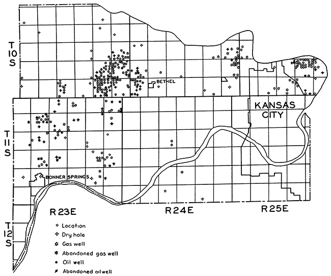
Prev Page--Subsurface stratigraphy || Next Page--List of wells and Bibliography
Kansas Geological Survey, Geology
Placed on web Jan. 27, 2014; originally published May 1935.
Comments to webadmin@kgs.ku.edu
The URL for this page is http://www.kgs.ku.edu/Publications/Bulletins/20/06_county.html